All Activity
- Past hour
-
Good boundary is moving south. Seems there might be an old remnant (from yesterday I guess) one north to south across western ffx county as well. Maybe that with the Reston UHI/city convergence can get something going.
-

E PA/NJ/DE Summer 2026 Obs/Discussion
BBasile replied to PhiEaglesfan712's topic in Philadelphia Region
Didn't see the rotation on radar for that. Mt. Holly says straight lines. -
Watching that outflow coming SE from PA while sitting on the stoop downtown and really hoping it at least brings a breeze as it hits us.
-
Storms cometh from PA. Hope they give us some more rain in Frederick.
-
Around 80 on the shoreline to upper 80's inland today. Dews upper 60's to low 70's. Mid 80's imby. Tomorrow starts the really hot stuff. We'll see how much.
-
Fizzle city again today
-
With Norway out, now I just want a toxic as hell France/England final.
-
No. Just fans. It never stays hot long enough to really need it.
- Yesterday
-
Yeah let's see if we can get a +500dm -NAO. In Super El Nino STJ that is the best case scenario. Feb 1983 was -NAO as whole. We have however seen 13 straight +NAO Feb's. Let's see if we can break that lol 2014 1.34 2015 1.32 2016 1.58 2017 1.00 2018 1.58 2019 0.29 2020 1.26 2021 0.14 2022 1.68 2023 0.92 2024 1.09 2025 1.60 2026 0.68 1983 -0.5
-
-
 Thats what I was envisioning. Either side of 80 with dews in 50’s. Very much like tomorrow. Same kind of setup despite a few wild folks buying the ops
 -
First time catching a Wilson Warbirds game, and of course, during the third at bat, torrential rain, with lightning and thunder. Only 0.03 at the house.
-
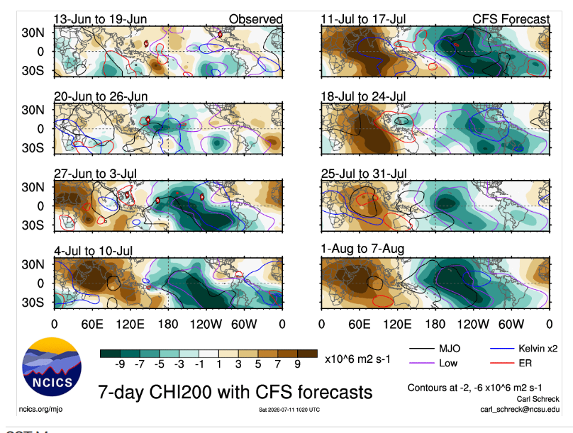
Figured id bring the ENSO thread back up after hibernation for 2 years,The DMI the last couple weeks has been getting stronger,it should mainly stay this way it is until late fall when it peaks in a more or less strong NINO, The MJO as we head towards the next several days seemingly is getting nothing but destructive interference from a Kelvin Wave,should seemingly go back into the WP shortly after but it could also warm the east up again from a downwelling Kelvin Wave. The east has some subsurface temps around 100W OF 8C,these temps dont dont peak out until fall into winter,NINO of 1982-83 had the highest temp anoms in the subsurface,so i guess it has a chance to surpass that,who knows right now
-
I agree with that take but wonder how it would go without a change into cross polar flow. When we rely on home grown cold it might be different.
-

E PA/NJ/DE Summer 2026 Obs/Discussion
Chadzachadam replied to PhiEaglesfan712's topic in Philadelphia Region
Quite a storm in Philly today. Saw some reports of a possible tornado in West Philly and wouldn't be shocked based on the damage I saw driving through West Fairmount Park. Severe tree damage, power was out and several spots were under a foot of water -
 Probably COC this time of year unless it gets more south for self destruction.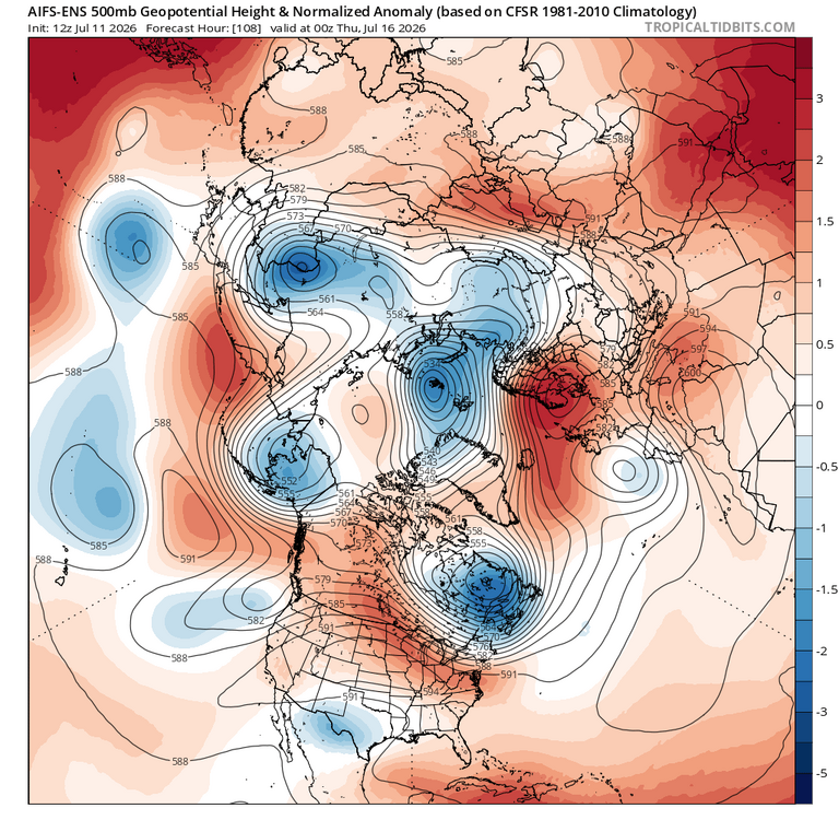
-
Not the case several times in recent winters- although most of those were Ninas. Jan 2022 is a perfect example(my storm.) We were in shut(shit) the blinds mode with no apparent end in sight and 10 days or so later there was a major snowstorm across much of the area, and it stayed pretty cold and snowed another time or 2.
-

E PA/NJ/DE Summer 2026 Obs/Discussion
shadow_ replied to PhiEaglesfan712's topic in Philadelphia Region
Everything falls apart when it sees the LV it seems the past few days. Maybe there is an invisible dome we can't see. -
Do you think the setup would still work with climate change? I ask as typically when our pattern is shit it takes a good while to ever get cold again.
-
97 in the point Monday.
-
GEFS/ EPS
-
This seems to concur.
-
Swing and a miss for Raleigh this afternoon. Always fun to see storms die on approach and blow up again to the east.
-
Another yard refresh, 0.09” brings MTD to 4.72”
-
H5 went from shit to sugar over about 10 days leading up.