All Activity
- Past hour
-
 I really like this guy and his discussions... He's been pretty spot on this far... NEWA Discussion – Stratospheric Zonal Wind Reversal Possible Before Thanksgiving According to the latest ECMWF ensemble 0z mean, the stratosphere may be gearing up for a zonal wind reversal just before Thanksgiving — something that hasn’t occurred this early in the season since the late 1960s. A stratospheric zonal wind reversal happens when the polar stratospheric winds — which typically blow west to east (westerly) during winter — suddenly shift to an easterly flow. This shift is often the direct result of a Sudden Stratospheric Warming (SSW) event and can have major downstream effects on our weather across North America and the North Atlantic for a long period of time. Once the stratosphere and troposphere couple, the result can be a disrupted polar vortex, opening the door to prolonged cold spells across the U.S. and Europe, or in some cases, unusual warmth in select regions depending on how the pattern sets up. If this potential reversal verifies, it would mark the first November event of its kind in over half a century — and could have major implications for early winter pattern development across the Northeast and Mid-Atlantic. Stay tuned to the Dashboard as I will be tracking the stratospheric trends closely as we head into the Thanksgiving period, and keep you updated..this is going to be fun I promise.
 -

11/8-11/10 First Snow and Lake Effect Event
King James replied to Geoboy645's topic in Lakes/Ohio Valley
Meh - no matter the wording, it was going to be extreme either way. I went to bed expecting 1-3 and woke up with about 14 inches. And I’m sure others went to bed expecting 14 and woke up with 3. Not sure how you win that forecast. The spread seemed reasonable. -
Could you clarify what DCL means?
-
I feel like this "south of Baltimore" storm track of the 8 years favors you more than most of us here, lol I still wanna know why it has been like this but most have said it's kinda random...but how does it repeat that long without a cause?
-
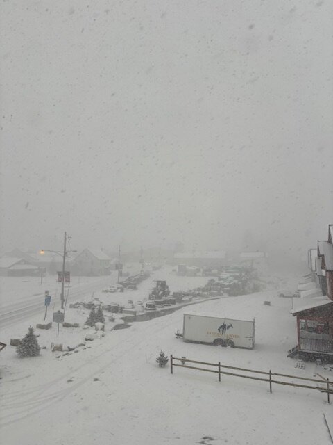
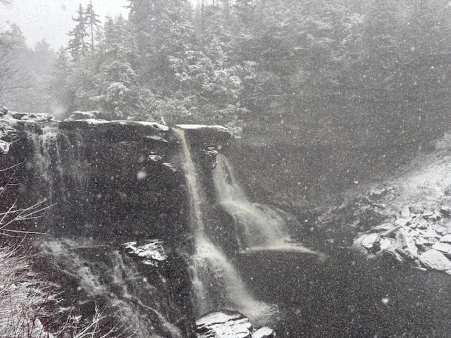
BlackWater Falls State Park and Davis this evening as snow picks up
-
I absolutely believe it. Front-loaded, classic canonical Niña December. Literally everything and I mean everything, atmospheric and oceanic is 100% La Niña. SOI, ENSO SSTs, subsurface, ONI/RONI, enhanced trade winds/EWBs, OLR, -IOD, global longwave pattern, MJO behavior, -AAM (about to tank negative again). All La Nina. No reason to doubt it or question it. Textbook canonical La Niña winter inbound….
-

E PA/NJ/DE Autumn 2025 Obs/Discussion
The Iceman replied to PhiEaglesfan712's topic in Philadelphia Region
I think it'll be similar to last winter... no big events, we nickle and dime to 10-15". I don't like that all these coastal's this fall have mostly been messes, nothing really organized because of how fast the flow is. I think we'll get cold, especially early, but seasons where we are banking on a stellar first half just almost always disappoint. All the forecasts of february being a torch are a downer considering that's our snowiest climo month. Plus in the last decade we've had good track storms early in the season, it just hasn't been cold enough. I like that the blocking signal is there late month and looks to hold strong. If we can score a 6+" in December then nickle and dime the rest of the season, I'll be happy. The pattern this fall hasn't screamed MECS to me at least imo -

Winter 2025-2025 Offers Return to Normalcy
CT Valley Snowman replied to 40/70 Benchmark's topic in New England
Nice analysis. I would sign for that in a heartbeat given our recent anemic snowfall amounts in this area. -

11/8-11/10 First Snow and Lake Effect Event
Chicago Storm replied to Geoboy645's topic in Lakes/Ohio Valley
You know who should be fired for that AFD on Sunday morning. -
Ominously dark. I’ve never seen this level of sky coverage from a flow event.
-
White Christmas here last year due to snow before the holiday. 1st time in a while.
-

Occasional Thoughts on Climate Change
WolfStock1 replied to donsutherland1's topic in Climate Change
Is there land under the bottom-left tip there? Interesting that that area remains stationary while the rest of the shelf continues moving. Based on the movement there it does look like it could break free at any time; the connection with that non-moving section looks very weak now. -
Good, maybe we can make something happen here snow wise in Dec for the first time since 2020.
-
It's crazy dark and windy here in Hickory. Feels and looks like snow. Raging virga storm on radar.
-
A lot of these snow showers are not falling apart in the slightest as they cross into the foothills. We may be in a rare scenario where there’s just enough instability and lift to overcome downsloping.
-
I think that batch coming out of e tn will deliver the goods
-
Game cam reports more snow at DCL with a high of 33F now 29F, at least at 3k ft.
-

2025-2026 Fall/Winter Mountain Thread
Maggie Valley Steve replied to Buckethead's topic in Southeastern States
Cataloochee Ski Area will officially open for the season this Wednesday! Tube World has the snow guns blowing and the hill is covered now! -
Back to back bands without sun dropped 3/4ths of an inch. After the second band the sun returned. Cloudy again now with another band minutes away.
-
(002).thumb.png.6e3d9d46bca5fe41aab7a74871dd8af8.png)
E PA/NJ/DE Autumn 2025 Obs/Discussion
ChescoWx replied to PhiEaglesfan712's topic in Philadelphia Region
My early winter take for Chester County is a cold start to December. Slightly below normal December and near to below temperature January with near to above normal February. Well above normal March temperatures. Snowfall not too far from average seasonal snowfall. 1 storm over 12" and 2 over 6" Chester County - higher elevations 40" of snow. Valley locations 35" of snow. -
Spruce Pine has a couple inches per family. Asheville has been sunny almost all day, I expected a bit more action here.
-
Per GSP (see last bit): Perhaps the main concern going forward will be to what extent snow showers will escape the containment of the current Warning/Advisory areas...as increasing coverage and intensity of showers means at least scattered snow showers will spill south and east toward the Blue Ridge escarpment. 1-3" of accumulation may become common across portions of northern Buncombe as well as the high elevations of Jackson, Macon, and Rabun Counties, with spotty/scattered instances of 1-3" south and east of there...depending upon where snow showers track. These accumulations aren`t enough to warrant an expansion of any Advisories, but Advisory-level snowfall can be expected on localized basis in the mountains counties outside of the WSW. Flurries and light snow showers are also expected to develop outside the mtns this evening, with some spotty dustings possible across the northern foothills and northeast Piedmont of NC.
-

2025-2026 Fall/Winter Mountain Thread
Sw NC weather replied to Buckethead's topic in Southeastern States
Had a heavy burst come through Franklin. Lasted 10-15 minutes. Coated everything other than the rd in a 1/4-1/2”. -
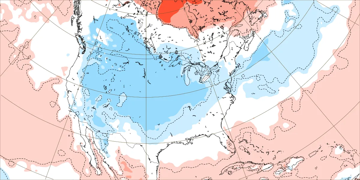
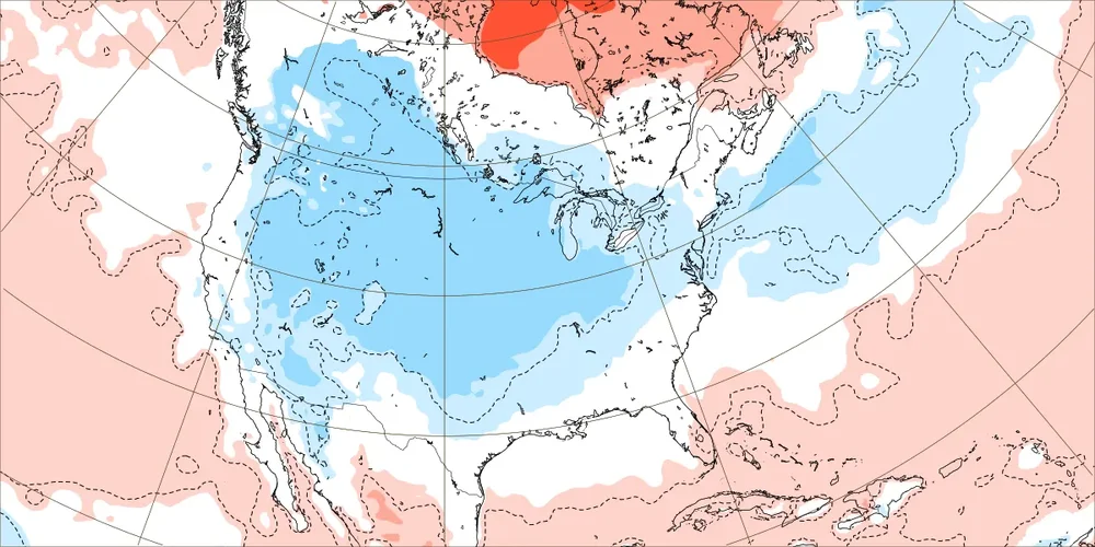
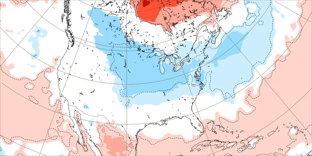
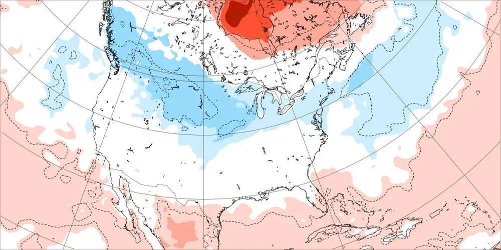
Euro Weeklies: coldest run yet for 1st 3 weeks in Dec for US overall. The maps don’t even have a speck of warmer than normal in the entire Conus except for S TX and S/C FL. Dec 1-7: Dec 8-14: Dec 15-21:
-

11-9/11-10 Early Season Snow Obs.
Holston_River_Rambler replied to John1122's topic in Tennessee Valley
Maybe some pareidolia on my part, but it almostlooks liek there is a little boundary running from central KY to near Greene county, TN: