All Activity
- Past hour
-

Augdewst 2026: Summer's Last Stand
HIPPYVALLEY replied to Prismshine Productions's topic in New England
Just incredible rainfall in this line. Probably picked up a half inch in just the past 10 minutes. -
Expand it to all PDO analogs.. +PDO is perferred Although we had record low -PDO in the Summer/Fall the last 2 years, and ended up having a cold Winter both times.
-
Line of showers/storms about to move across Newfound Lake. My webcam site should be fun to watch. https://www.bridgewaternhweather.com/
-
Heavy thundershower out in Croom where I was for work. Snuck up on me. When it got dark in the forest I’m glad I know to B-line it right to the truck lol.
-
Augdewst 2026: Summer's Last Stand
HIPPYVALLEY replied to Prismshine Productions's topic in New England
We don’t get those in SNE anymore. -
Squall line kinda fell apart over the city and sun is breaking out now. Ended this event with 1.26"...over 2/3 of an inch less than LGA a few miles to my west. I'll take the less rain though, since we're running above normal in general for the last few weeks.
-
Sun trying to come out here. Hoping we can dry out rest of week and miss whatever rains are out there.
-

Augdewst 2026: Summer's Last Stand
HoarfrostHubb replied to Prismshine Productions's topic in New England
You mentioned last week (Thursday?) that today looked interesting -
Did all the yardwork and mowing yesterday and looks like I need to go mow again tomorrow. Lol wow.
-

Spring/Summer 2026 Pattern Discussion Thread
John1122 replied to Carvers Gap's topic in Tennessee Valley
I'm getting an absolutely epic downpour right now from one of those SW moving rain showers. No thunder but massive raindrops. -
It's official: [Jeff Passan] BREAKING: The Boston Red Sox are acquiring three-time All-Star catcher Adley Rutschman in a trade with the Baltimore Orioles, sources tell ESPN. https://bsky.app/profile/baseballtradenews.bsky.social/post/3ms75qvpsq22w
-
Yesterday was the 3rd total failure for this summer with a Flood Watch for the 81 corridor. This is becoming embarrassing for NOAA. Augusta is the second largest county in Virginia. A 9 station sample averaged .33" for Augusta Yesterday. The heavy rain was from southeasterly up-slope on the eastern flank of the Blue Ridge. Charlottesville 2.51, Ruckersville 1.94", Sperryville 1.53, Batesville 2.20", Crozet 1.29, Wintergreen on the eastern face of the Blue Ridge, 1.74". The Flood Watch should have been limited to counties east of the Blue Ridge. A Flood Watch is the Kiss Of Death for the Valley.
-
prayers 4 powerball
-
^I wish. We're in a nasty 7-year trend in March
-
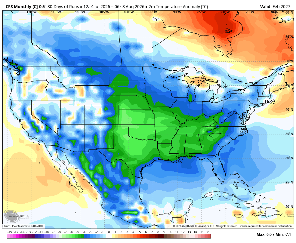
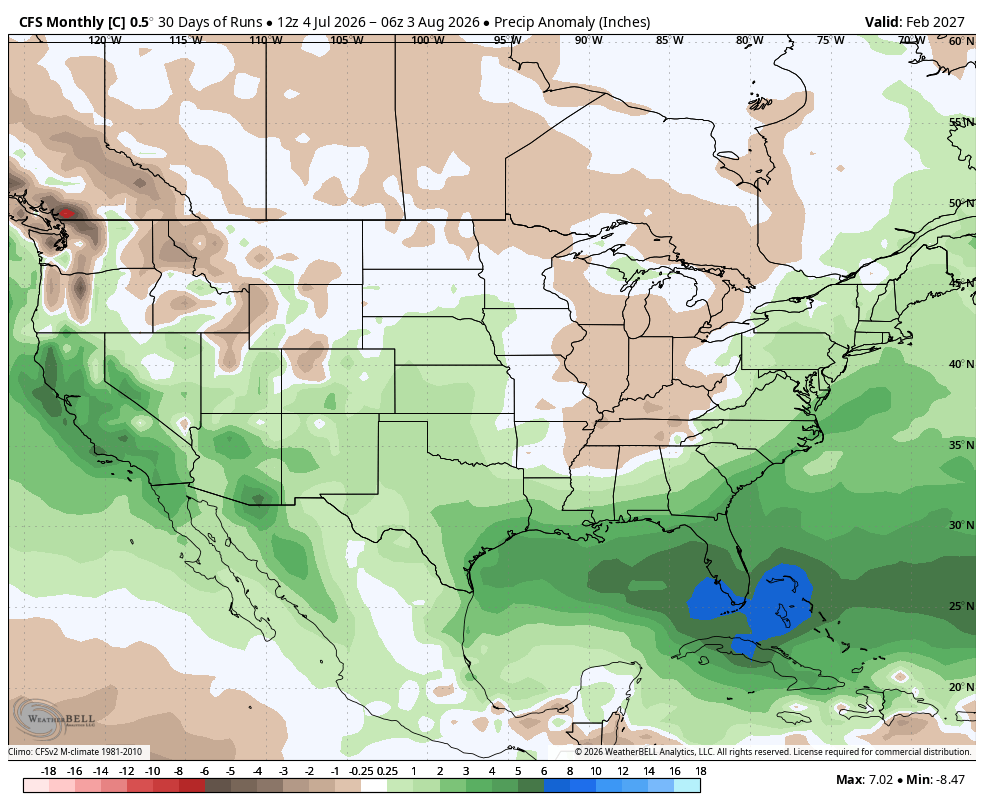
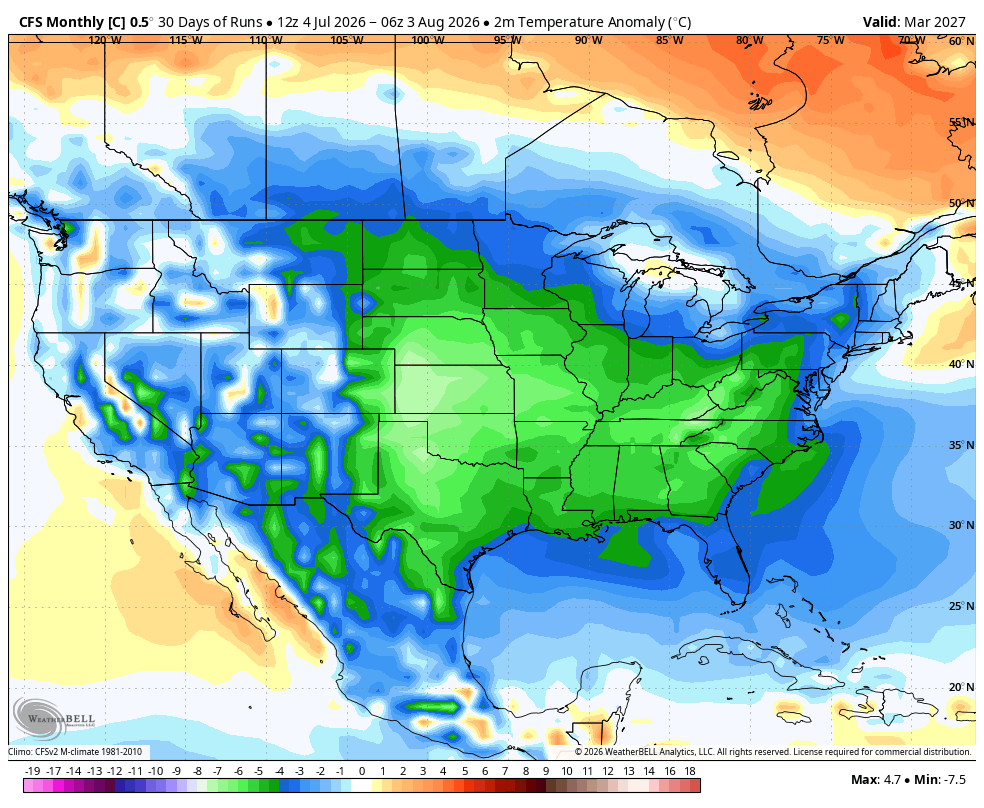
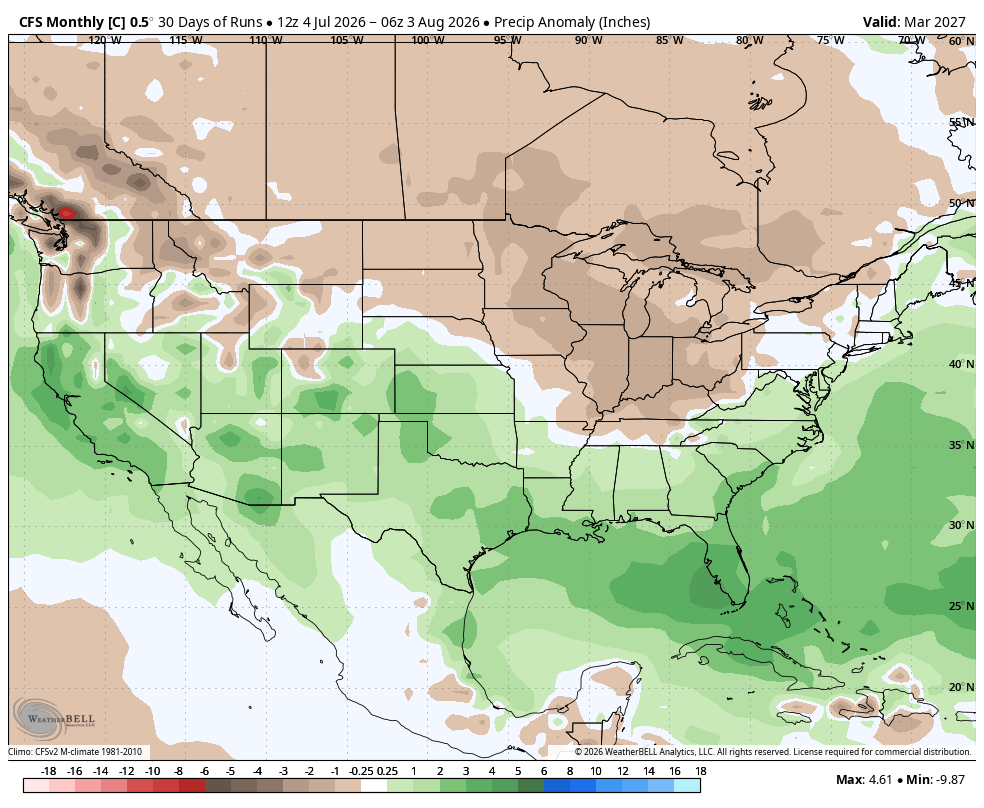
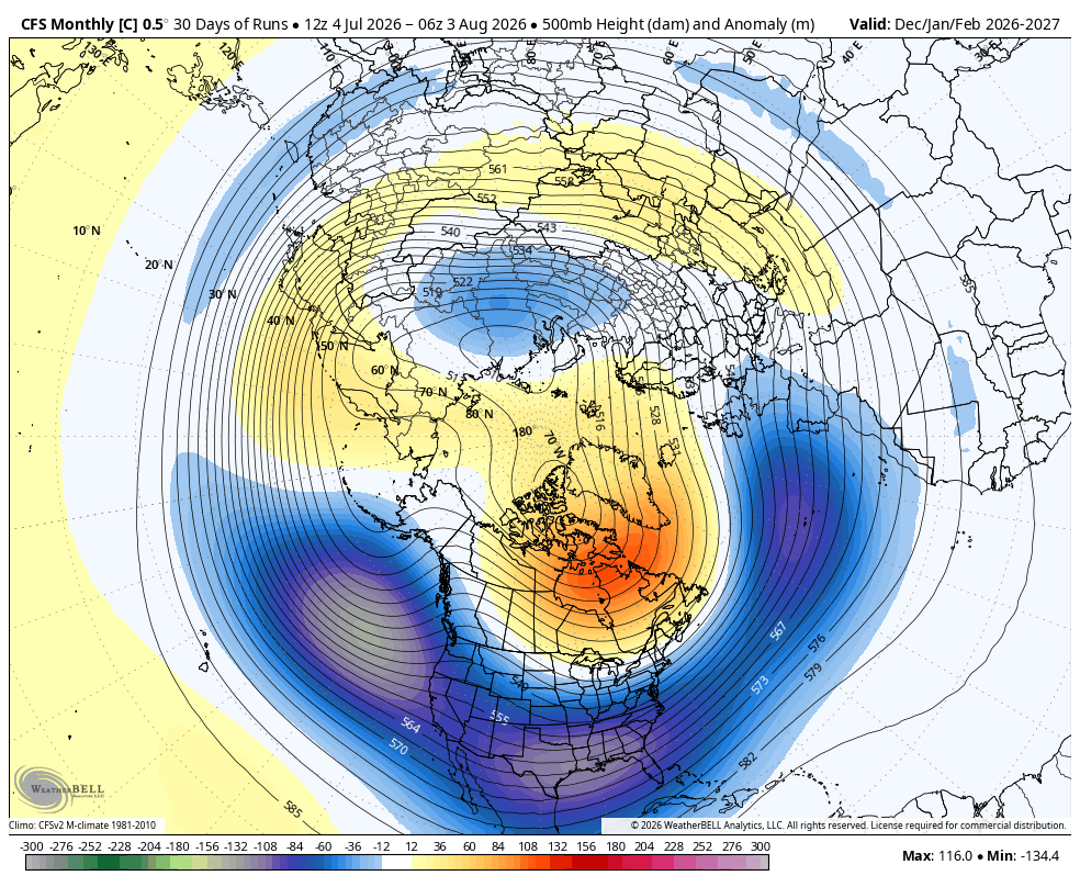
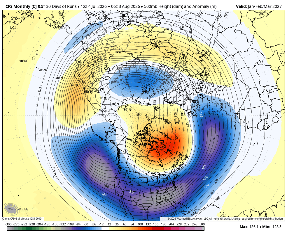
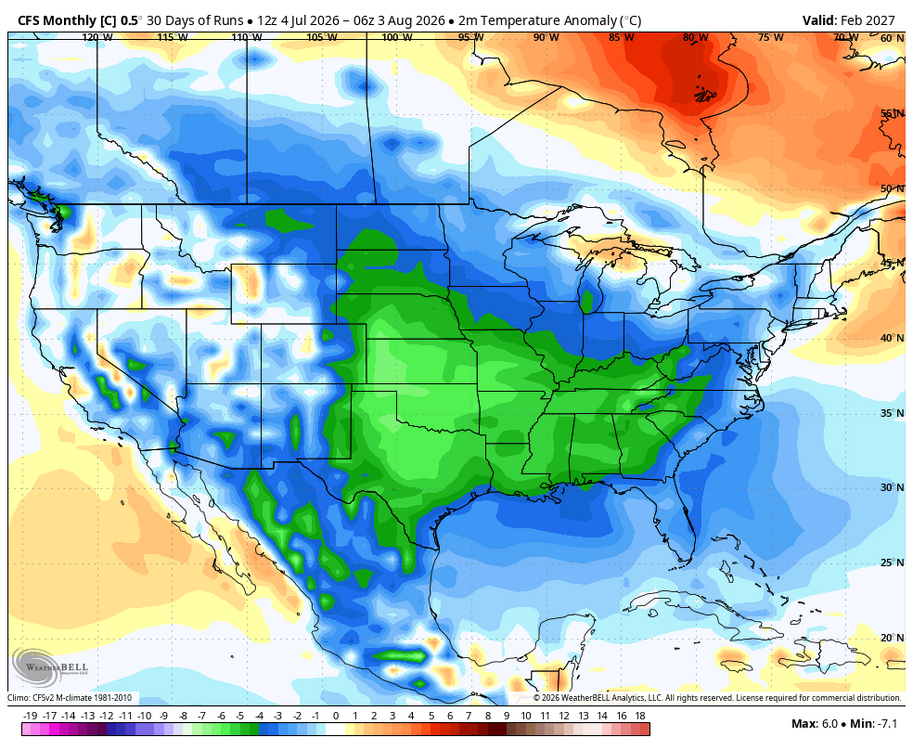
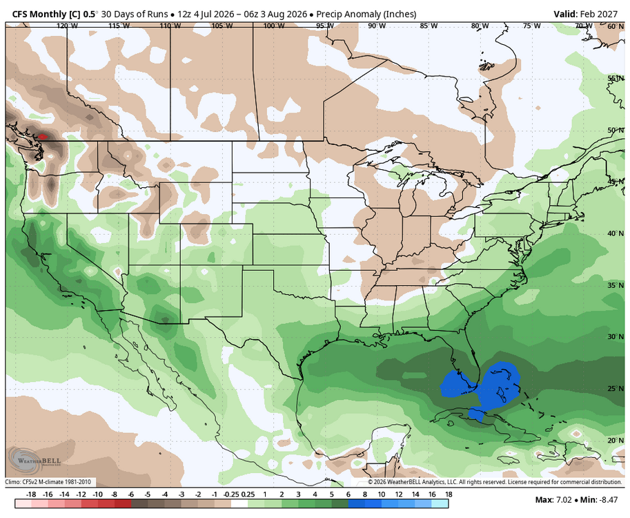
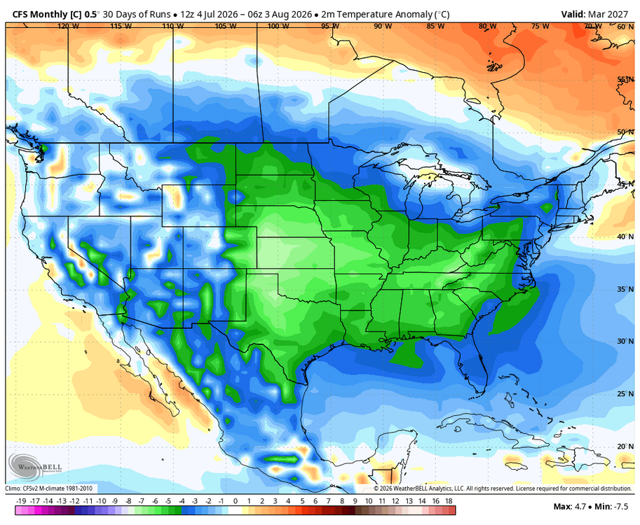
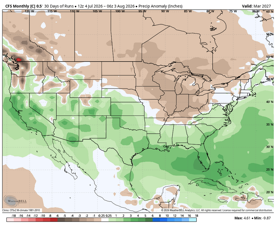
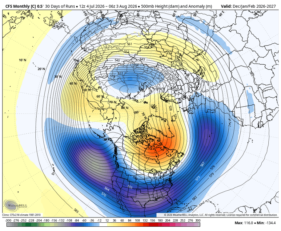
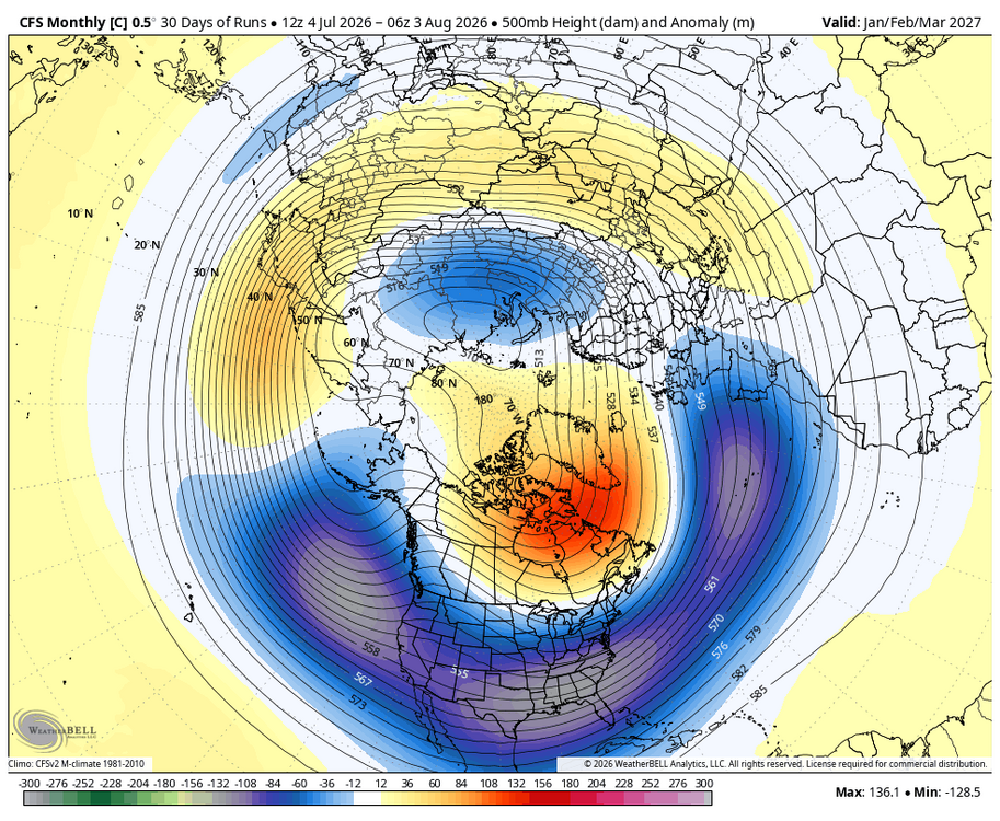
WB CFS 30 Days of Run average Dec. thru March temp. & precip. Anomalies...hope this verifies. Added 500MB anomalies for Dec-Feb. and Jan. Thru March
-

Mountain West Discussion
mayjawintastawm replied to mayjawintastawm's topic in Central/Western States
At my house near Centennial Airport we've received 5.05" YTD. DEN is a bit better at 5.65". Record driest year is 7.48" in 2002. I'm guessing we won't quite end up that dry, but it will be close. Good shot at top 10 driest, anyway. - Today
-
My guess to your query - near continuous cold and most storms not having mid-level warm tongues to wreck aggregates and/or changing P-type. We had some rain, not a lot, but almost no mixed precip or rimed flakes. February 2026 was our driest with 0.76", but it was 100% snow, 12.5" for a 16.4-to-1 ratio. Without looking thru the data, I can't recall any month that had nothing but flakes. Oddly, 2020-21 was our lowest ratio at 7.08. It was our 2nd least snow, ahead of only 15-16, and almost every snowfall either had mix or was cornmeal. The season's biggest storm, 9.5" on 2/2, was the latter, 1.32" of teeny flakes, ratio 7.2-to-1.
-
As many of us are in this region, this year Fort Collins will be flirting with recording the driest year in recorded history (which is 7.34"). Currently we sit at 5.97" for the year. It seems we start getting some decent monsoon moisture and then the door gets slammed shut again. Supposedly El Nino conditions are forecast this fall but I'm not holding my breath that it will make any difference in alleviating the drought. One can hope tho....
-

2026-2027 Super El Nino
PhiEaglesfan712 replied to Stormchaserchuck1's topic in Weather Forecasting and Discussion
lol, they must have changed it. The original value there was -2.03 a few hours earlier. I guess they put the WCS value. But now we know there is about a .75 difference between the NOAA and WCS in July. -
I've just been looking at 500mb daily maps and we've had 4 good low peaks in the arctic this Summer. I think the actual AO index is not as positive as the -H5. PNA is recovering finally after a negative start to August. Let's see if it continues!
-
I truly hope this El Nino comes in weaker, but that seems unlikely.
-

Pittsburgh PA Summer 2026 Thread
PghPirates27 replied to TheClimateChanger's topic in Upstate New York/Pennsylvania
About 3.8” for the event yesterday. Not a bad rain. -
Interesting how strong El Niño has the highest snowfall on average, but it’s the moderate El Niño which is the coldest on average. The snow plot for super El Niño events is what we all know which is we gotta get hit or we get nothing. The most concrete thing it showed was that this winter will be warm as the super El Niño is by far the highest temp anomaly.
-
 S'appuyer sur [url=https://newsfrrx.sbs/#]Santé Homme France[/url] permet faire des économies.
 -
That wouldn't make much sense though--why would the owner and Elias fire Alby when they just brought him in? Elias AND Alby out would be more like than that, imo