All Activity
- Past hour
-
Some very light rain in downtown Baltimore for the last hour. Looks like maybe a few areas from here up to the PA line in Balt Co and Harford Co might catch a few storms this afternoon. Maybe. Sure isn't area-wide coverage unfortunately.
-
Doesn't look like the sun will be making too many appearances today.
-
That's what the regular season finale should be known as from 2025 for the Patriots
-
Just mist and drizzle here so far. 61 degrees
-
lol this is weird, do you realize I wrote the exact same thing you did but in the ENSO thread? Nature's forms of balancing may well be saturated. They are the only thing that held back a Venus type runaway greenhouse effect. That dam may have broken.
-
50.2° RA Stinko de Mayo
-
paradoxically, all those nukes going off at once would actually be a good thing if looked at through the lens of climate change, as it would result in a sudden and immediate drop in temperatures.
-
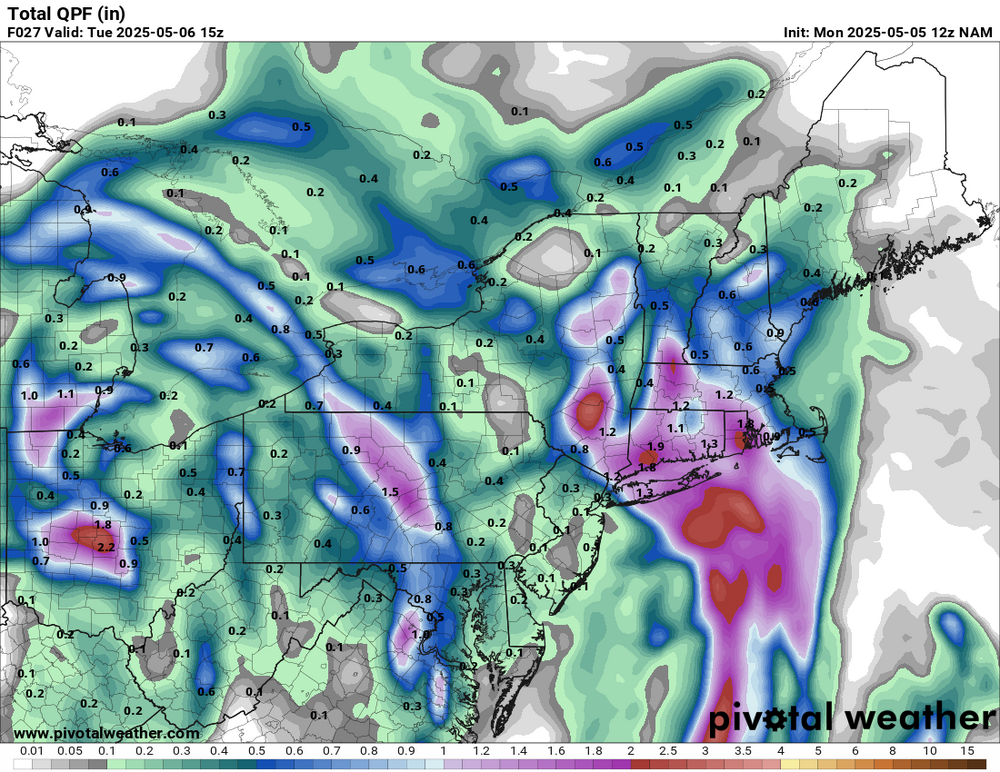
That southwestern edge of the heavy rain will have to move a bit SW on this map judging by the heavy batch about to spin into NYC and LI.
-
W Suffolk, and Nassau are about to get into the good stuff. Pouring in Brightwaters.
-
science fiction writers are smarter than most people and have been incorporating this into their stories (as well as environmental collapse) going all the way back to the 1920s.
-
About to rip on the island. This batch coming in from the south means business. Should drop a quick inch. Rates in these setups often exceed radar depiction.
-
the reason coastal areas have warmed more is because the oceans are heatsinks. We're very lucky the oceans are there to do that, otherwise the entire planet would have become like Venus already. It might yet one day anyway when the oceans become so warm they are completely saturated with heat.
-
It's interesting how much the ocean has sucked up the heat which has stopped the increase of 90 and 100 degree heat which peaked in the 1990s (with another peak from 2010-13). The earth is trying to balance out humankind's excess by dumping the heat into the ocean, let's see how long that lasts.
-
Looks like the axis of the most favorable parameters shifts quite a bit throughout the day. This is going to give alot of "false hope" for some because for the areas getting hit now and will later and the areas missing out...those areas missing out will eventually get it. Tomorrow is going to be interesting with a quite a bit of convective elements involved. PWATS are quite high for the entire region through tomorrow so just about everyone is going to get involved at some point.
-
Yeah. Tough forecasting specifics in any one location.
-
Got down to 44 last night.
-

E PA/NJ/DE Spring 2025 Obs/Discussion
Mikeymac5306 replied to PhiEaglesfan712's topic in Philadelphia Region
Nothing on our plate but drizzle and fat in West Chester. Was supposed to golf today. Could have played. Glad we didn't though. Rescheduled for next week. -
That end of week into Saturday costal idea the Euro has. Hopefully that can be tossed as we get closer. Seems very suspicious
-
Seems like models sort of all over the place with the rain.
- Today
-

Central PA Spring 2025
Itstrainingtime replied to canderson's topic in Upstate New York/Pennsylvania
Enjoy your time in PA! -
Got 1.6” this past event.
-
 Let’s keep discussion of this here instead of the drought buster and long range thread.
 -
Slight Risk today for wind and hail.
- 464 replies
-
- 1
-

-
- severe
- thunderstorms
- (and 2 more)
-
Congrats north and eastern areas
-
Euro seasonal update is out today - trying to get more details. https://x.com/davethroup/status/1917659431531053391?s=46


