All Activity
- Past hour
-
73 / 66 clouds. Brunt of the rain into NY State / north so far. Showers/ storms later still should yield >0.5 - 1.00 and more northern areas or where heavier stoems focus locally. Clouds linger into Tuesday as trough is in the northeast. Wed - / Thu look very nice warm / sunny and dry. We may be pulling up to a split weekend with Rain / storms Fri evening into Saturday / dry sunday. Moderation warmer / heat to close the month and open next. Overall warmer 6.28 and beyond.
-
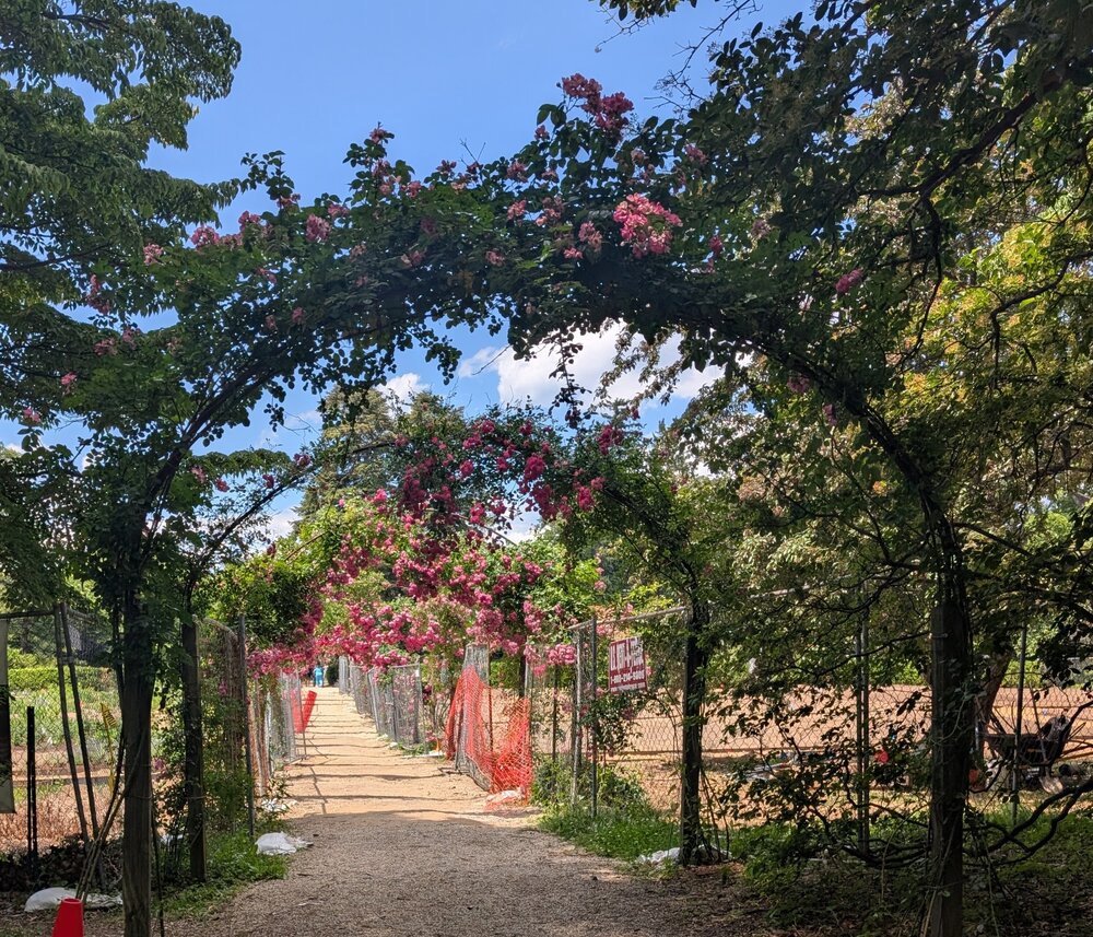
A beautiful Father's Day at Planting Fields Arboretum in Oyster Bay.
-
More of a heavy rain threat. Skies have cleared here for the most part.
-
sun angle should limit major accumulation today
-
Need an AI version with Stein dancing in that video instead of MJ.
-
I've noticed mine isn't growing nearly as I remember in years past. Everyone's lawns are looking crispy and it's not even July. I hope we get a decent amount of rain tonight into tomorrow.
-

2026-2027 Super El Nino
GaWx replied to Stormchaserchuck1's topic in Weather Forecasting and Discussion
My progs were right this time: 1+2………3…….3.4…….4 29APR2026 0.6 0.4 0.4 0.5 06MAY2026 1.0 0.5 0.4 0.5 13MAY2026 1.3 0.6 0.4 0.6 20MAY2026 1.6 0.7 0.5 0.6 27MAY2026 1.7 0.8 0.5 0.7 03JUN2026 2.1 0.9 0.7 0.7 10JUN2026 2.1 1.0 0.9 0.7 17JUN2026 2.4 1.3 1.1 0.8 https://www.cpc.ncep.noaa.gov/data/indices/rel_wksst9120.txt -

2026-2027 Super El Nino
FPizz replied to Stormchaserchuck1's topic in Weather Forecasting and Discussion
He stays unchanged no matter what, even after busting as big as you possibly could last winter while he was digging out from over 50" of snow when he averages 25". -
You’ve been hit by a smooth criminal.
-
Just noticed that. Pretty much clear now. LFG! Big gully washers for the win!
-
I would be down for that. Give me some good thunder for awhile.
-
We have seen that time and time again in the past. No flood watch for the island. .
-
The state of Falls Lake as of 6/21/2026 near Santee Road Point in Durham (Falls Lake is a main source of water for Raleigh).
-

Central PA Summer 2026 Discussion/Obs Thread
pawatch replied to Voyager's topic in Upstate New York/Pennsylvania
62 degrees and just started raining. -

E PA/NJ/DE Summer 2026 Obs/Discussion
LVLion77 replied to PhiEaglesfan712's topic in Philadelphia Region
I watered the garden on Sunday just in case we get another 7-10 split! -
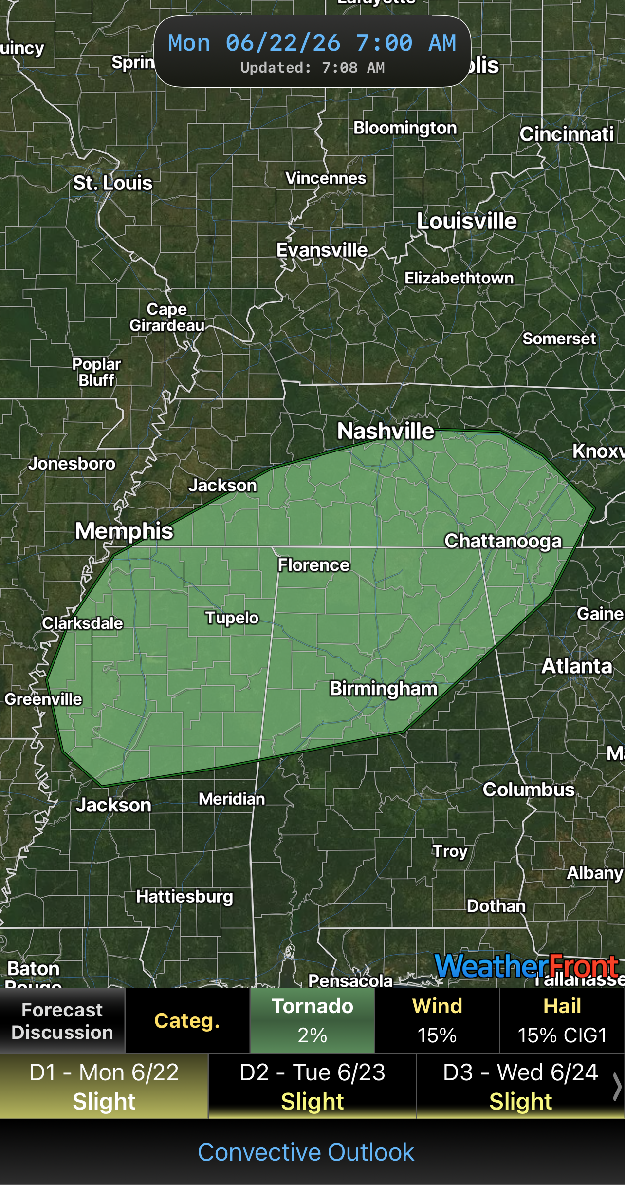
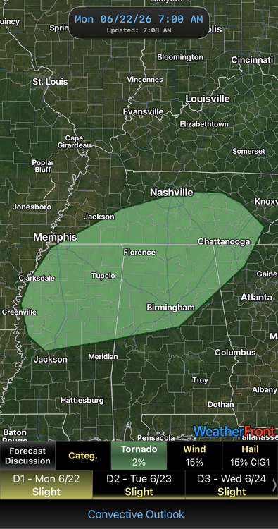
Flood Watch 1-3 inches expected FFA from KOKX HRR has been all over the place with the precip/storm placements in the metro- same with the NAM - definite NOWCASTING event
-
Looks like I might have a chance to chase after all this evening if things go right. SPC extended the 2% tornado just to my north. As @nrgjeffsaid, 2% strong Date: 6/22/2026 @7:10 AM
-
Clearing out now
- Today
-
Hopefully they become big ole, slow moving gully washers with lots of lightning. Severe around here is always really isolated. I feel like the majority of it comes from random down burst during summer thunderstorms. I remember widespread straight line winds once in my nearly 50 years here. Tornados are rare unless you live in La Plata. Evidently that town has been flattened more than once.
-

Central PA Summer 2026 Discussion/Obs Thread
mahantango#1 replied to Voyager's topic in Upstate New York/Pennsylvania
Seen this at the theater in Wilkes Barre when it came out, and got the dvd...well worth seeing excellent! Agnes Flood Documentary Project npreodstoSa1c648t3l61l73h53alu3ci3452f7iatum381uh21001817070 · On this date in 1972 - June 21 - torrential rains were hitting the Wyoming Valley. "Agnes" was here. Two days later, the people of the Wyoming Valley experienced what, to this day, is simply referred to as "The Flood." It was the worst natural disaster in U.S. history. On Wednesday June 24, the story of those days, and the weeks and months that followed, will be told when "Agnes" returns to the big screen at the F.M. Kirby Center. Showtimes are 1 p.m. and 7 p.m. Tickets will be available at the box office at showtime, or can be purchased in advance by visiting www.kirbycenter.org or by calling (570) 826-1100. https://www.facebook.com/reel/963239149844407 See less -
Not to be a deb, but this doesn't look as impressive on the severe side as it did a few days ago. Definitely a chance for multiple rounds of thunderstorms today, but the overall spatial coverage and helicity seem to have backed off.
-
hit by what? i am at 1.25" MTD
-
Hope that’s not case, need something beneficial out of this. Next shot would be Friday.
-
If you're not in the stratiform rain zone which our subforum won't, we're relying on convection to produce any rain we get. If that misses or fails to materialize we get skunked.
-

E PA/NJ/DE Summer 2026 Obs/Discussion
Hurricane Agnes replied to PhiEaglesfan712's topic in Philadelphia Region
Well here's something we haven't seen much of in awhile - Stuff was starting to brown up so need the rain. I have 3.36" for the month so far. Currently overcast and 71 with dp 64.


.thumb.jpg.049f4a7f726ada07e8cd30bd17e713cb.jpg)