All Activity
- Past hour
-
A few days of warmth late month and early July and then cools off a ridge retros. Close to cancelling summer.
-

Wet late Monday 6/22 or another Fizzle?
JenkinsJinkies replied to Weather Will's topic in Mid Atlantic
Thing is this is such a small area that a decent sized squall line would impact 90% of us. -
I've seen this so many times this spring into early summer, this tendency for front side cirrus/cloud debris to erode back west, as the total miasma is attempting to move in from the eastern Lakes/N OV. We steal front side decent days and I suspect some QPF error occurring because this drying may not be well handled - speculation on that idea. In any case, it's endemic of some sort of vestigial if not outright troughing in the Maritime of Canada. I say "vestigial" because it's not abundantly clear why that is doing that. So perhaps something lingers that's less coherent. The NAO is actually neutral when this has been happen - either way... not obviously negative in the charts, either. It's like there's some sort of hybrid or very week -NAO that is below the threshold of numerical detection in the EOF. Tempted to say "non-linearity" ... that's when there emergent forcing where the why-for isn't very readily - if at all - coherent to the observer. Complex. Meanwhile, W and NW Europe is being punished and persecuted by a Hadean heat wave after heat wave. In classical telecon methodology/correlative spatial relationship ... western Europe is positive correlated to eastern N/A mid latitudes. This has been failing miserably. This isn't first spring and summer over the recent 10 years whence I observed this apparent statistical oddity. I dunno... maybe it's a related thing. Maybe something of a local decadal odd-ball fractal. But we're supposed to be hotter than we have been.
-
It's a good soaking for most tomorrow morning. And I wouldn't call its forecast for today a fizzle; it's just more isolated with its heavier amounts, and it's a bit of an outlier in that regard.
-
(002).thumb.png.6e3d9d46bca5fe41aab7a74871dd8af8.png)
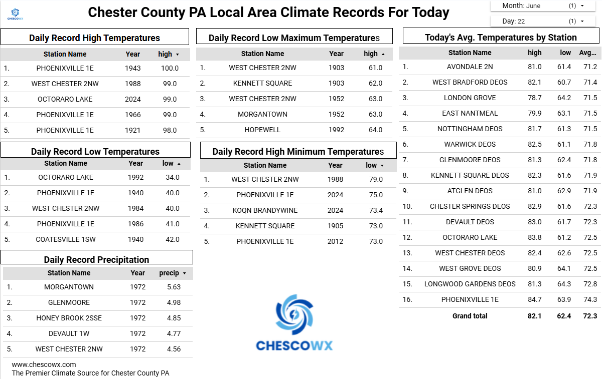
Central PA Summer 2026 Discussion/Obs Thread
ChescoWx replied to Voyager's topic in Upstate New York/Pennsylvania
A Flood watch is in effect starting at 2pm today. Rain will arrive from west to east later this afternoon. We could see some thunderstorms. There is still some uncertainty to where the heaviest rain will fall. For now it appears from 0.5" across NW Chesco to over an inch possible toward SE Chester County. Highs today and tomorrow will be several degrees below normal with the clouds and rain. We dry out later Tuesday through much of Thursday before more rain arrives Thursday night into Friday.
-
E PA/NJ/DE Summer 2026 Obs/Discussion
ChescoWx replied to PhiEaglesfan712's topic in Philadelphia Region
A Flood watch is in effect starting at 2pm today. Rain will arrive from west to east later this afternoon. We could see some thunderstorms. There is still some uncertainty to where the heaviest rain will fall. For now it appears from 0.5" across NW Chesco to over an inch possible toward SE Chester County. Highs today and tomorrow will be several degrees below normal with the clouds and rain. We dry out later Tuesday through much of Thursday before more rain arrives Thursday night into Friday.
-

Occasional Thoughts on Climate Change
donsutherland1 replied to donsutherland1's topic in Climate Change
All-time temperature records are again falling in France. As of early this afternoon (local time), 2026 had produced the tenth most all-time records for any calendar year (and second most in June). By the close of today, 2026 will very likely rank 6th highest. Seven of the ten years with the most all-time records have occurred since 2015.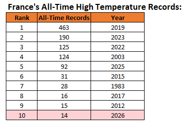
-

2026-2027 Super El Nino
BlizzardWx replied to Stormchaserchuck1's topic in Weather Forecasting and Discussion
This is a good point because it may well be pretty similar to what we end up doing in the N Pac this winter, with warm water east of Japan AND along the west coast. Yeah its a problem when we only want to use recent years as analogs yet all of those years are biased towards -PDO and +AMO. That won't work when we buck the trend. -
Most of the area will see little to no rain
-

Wet late Monday 6/22 or another Fizzle?
Weather Will replied to Weather Will's topic in Mid Atlantic
Cloudy again here. WB 12Z HRRR through midnight is not impressive for most of us. More of a fizzle I'm afraid....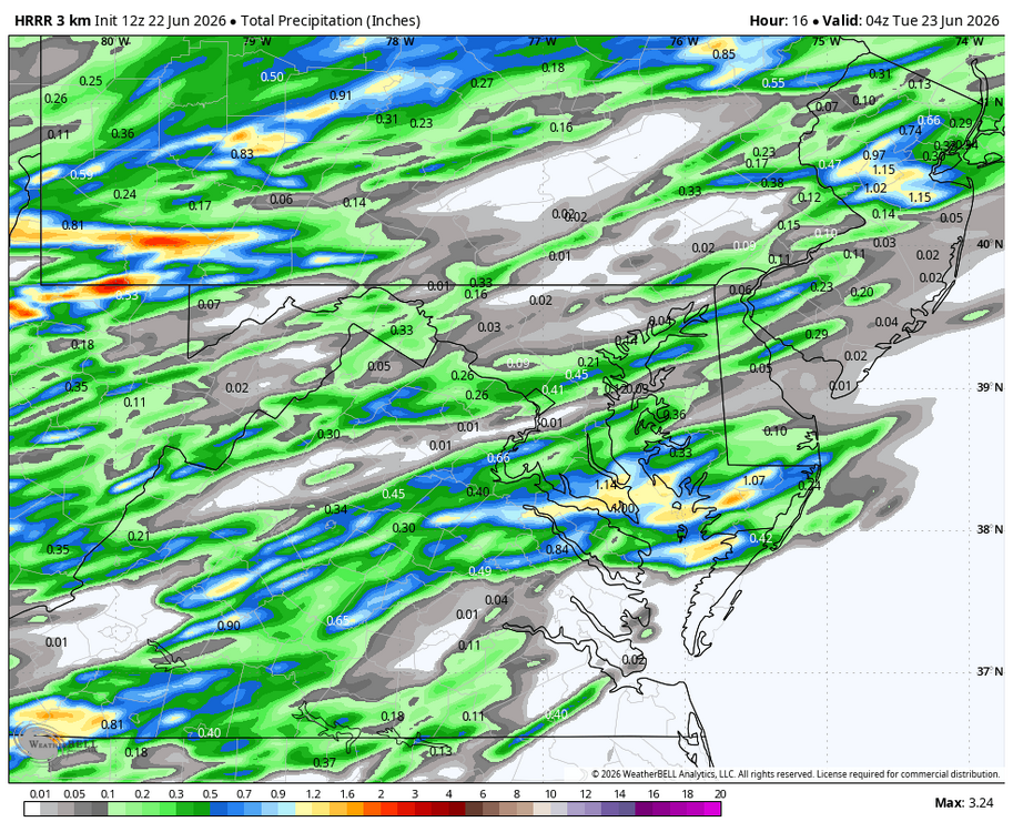
-
No changes really on the 13z SPC outlook.
-
I'm not really sure where the convection will come from to produce these thunderstorms. With overcast skies, it maybe reaches the low-mid 70s at best, so there will be little heating up of the surface.
-
May get some loud overnight elevated convection tonight across SE CT into MA and far SE MA
-
That number is only going to skyrocket with yesterday's tors too.
-

2026 Mid-Atlantic Severe Storm General Discussion
batmanbrad replied to Kmlwx's topic in Mid Atlantic
does look clear esp. over MoCo as of now, though there are some clouds to the west so unless those dissipate as they move out of the mountains, we'll probably have intervals of both clear skies and some cloud cover:
- 824 replies
-
- 1
-

-
- severe
- thunderstorms
- (and 7 more)
-

Wet late Monday 6/22 or another Fizzle?
BlizzardNole replied to Weather Will's topic in Mid Atlantic
Gimme that! I don't want severe. I'd love to see multiple rounds including some after dark with lightning and long, rolling thunder. -
Good amount of sun on the way to work this morning.
- 824 replies
-
- 2
-
-

-
- severe
- thunderstorms
- (and 7 more)
-

2026-2027 Super El Nino
LakePaste25 replied to Stormchaserchuck1's topic in Weather Forecasting and Discussion
It goes both ways. When some of us throw 97-98 into the mix, we aren’t saying the snow totals will repeat verbatim. Some of this is just random variability. 97-98 came extremely close to a producing KU’s a couple of times and could actually produce one if the general pattern repeated. So people shouldn’t freak out that their snow is being taken away when that year is mentioned. -
Just dancing around Kevin asking “Kevin are you ok, so Kevin are you ok, are you ok Kevin?
-
Best of luck thunderstorms, we're all counting on you.
-
-
-
Records: Highs: EWR: 101 (1988) NYC: 98 (1988) LGA: 99 (1988) JFK: 94 (2012) Lows: EWR: 48 (1940) NYC: 52 (1940) LGA: 52 (1992) JFK: 55 (1992) Historical: 1886: At Lynchburg, a "terrific rain" led to street flooding, setting a new record for the wettest June at the site (5.44 inches Record at this time). In Washington, DC, (4.16 inches Record at this time) of rain fell on the 22nd alone, setting a 24-hour rainfall record for June. (Ref. for Heavy Rainfall) 1906: A destructive hailstorm struck the town of Chelsea, VT, covering an area 1 by 10 miles. There were drifts up to two feet deep, and most crops were destroyed. (Ref. Wilson Wx. History) 1919: 59 people were killed as an F5 tornado ripped through the town of Fergus Falls, MN. 400 buildings were destroyed. A blank check was found over 60 miles away and lumber was carried 10 miles. (Ref. Wilson Wx. History) 1928: A farmer near Greensburg, KS looked up into the heart of a tornado. He described its walls as "rotating clouds lit with constant flashes of lightning and a strong gassy odor with a screaming, hissing sound." 1944: A violent tornado, which touched down in southwest Wisconsin, crossed the border into Illinois, northeast of Freeport. Both states had at least $1 million damage each. In Illinois, 66 farms lost barns, and 21 homes were destroyed. Two people were killed in Illinois, with seven more in Wisconsin. (Ref. Wilson Wx. History) 1947 - Twelve inches of rain fell in forty-two minutes at Holt, MO, establishing a world rainfall record. That record was tied on January 24-25, 1956, at the Kilauea Sugar Plantation in Hawaii, as their state record was established with 38 inches of rain in 24 hours. (The Weather Channel) 1972 - Hurricane Agnes deluged Pennsylvania and New York State with torrential rains resulting in the most costly flood in U.S. history. In the Middle Susquehanna Valley of Pennsylvania, 24 hour rainfall amounts were generally 8 to 12 inches, with up to 19 inches in extreme southwestern Schuylkill County. At Wilkes-Barre, PA, the dike was breached destroying much of the town. Flooding resulted in 117 deaths and 3.1 billion dollars damage. (David Ludlum) 1981 - A young woman from Lubbock, TX, was struck by lightning. The bolt of lightning struck just above her right shoulder near her neck, and passed right to left through her body, tearing her warm-ups, causing her tennis shoes to explode, and lifting her two feet into the air. (The Weather Channel) 1987 - Thunderstorms in southern Texas produced wind gusts to 116 mph near Quemado. Thunderstorms in New York State produced 5.01 inches of rain in 24 hours at Buffalo, an all-time record for that location, and produced an inch of rain at Bath, PA. The temperature at Fairbanks AK soared to 92 degrees, establishing a record for the date. (The National Weather Summary) (Storm Data) 1988 - Sixty-five cities in twenty-four states reported record high temperatures for the date. Tucson AZ reported an all-time record high of 114 degrees, surpassing the previous record of 112 degrees established a day earlier. Highs of 98 degrees at Pittsburgh, PA, and 100 degrees at Baltimore, MD, tied records for the month of June. (The National Weather Summary) 1989 - Record cold temperatures were reported in the High Plains Region. Rapid City, SD, reported a record low of 39 degrees, in sharp contrast to their record high of 102 degrees two days earlier, on the 20th. (The National Weather Summary) 1992: Record cold prevailed in the eastern U.S. with many low temperature records for the date tied or broken. Indianapolis, IN dipped to 37° to set a new all-time record low temperature for June and the coldest summer temperature ever. At Muskegon, MI the temperature plummeted to 32°. It was the latest freezing temperature on record there. In sharp contrast, it was a furnace in the Pacific Northwest with Eugene and Medford, Oregon setting new all-time record high temperatures for June with 102° and 111° degrees, respectively. (Ref. Wilson Wx. History) 1993: Measurable rain would fall every day from the date until July 25th somewhere in Iowa. The highly unusual weather pattern that produced this nearly continuous rainfall would result in the greatest flood in U.S. history as 15% of the contiguous United States was affected. It would be one of the United States most costly natural disasters ever along with Hurricane Andrew of 1992. (Ref. Wilson Wx. History) 2003: A hailstone measuring 7.0 inches in diameter with a circumference of 18.75 inches and weighing 1.33 pounds falls in Aurora, Nebraska. The National Weather Service reports this is the second largest hailstone ever documented in the U.S. by weight, and the largest by size at that time. The world's largest hailstone NOW was produced from storms in South Dakota; 8" in diameter and 1.9375 lbs. on July 23, 2010. 2009: Florida: Temperature records tumble with Vero Beach leading the record heat parade with a record high of 102°F and a heat index of 111°F. Elsewhere in the state, Tallahassee hits 103°F; Daytona and West Palm Beach, 96°F and Miami 98.°F. (Ref. WxDoctor) 2016: June 22-24. Part of a severe weather outbreak that produced over two dozen tornadoes from Illinois to West Virginia, up to 10 inches of rain fell in just 12-24 hours on June 23, setting off West Virginia's third deadliest flood. Twenty-three people lost their lives.
-
73 / 66 clouds. Brunt of the rain into NY State / north so far. Showers/ storms later still should yield >0.5 - 1.00 and more northern areas or where heavier stoems focus locally. Clouds linger into Tuesday as trough is in the northeast. Wed - / Thu look very nice warm / sunny and dry. We may be pulling up to a split weekend with Rain / storms Fri evening into Saturday / dry sunday. Moderation warmer / heat to close the month and open next. Overall warmer 6.28 and beyond.
-
A beautiful Father's Day at Planting Fields Arboretum in Oyster Bay.