All Activity
- Past hour
-
1993 was the leader in 95° and 100° days at Newark. 95° days at Newark Time Series Summary for NEWARK LIBERTY INTL AP, NJ - Jan through Dec Click column heading to sort ascending, click again to sort descending. 1 1993 25 0 2 2010 21 0 3 2022 20 0 - 1988 20 0 - 1944 20 0 4 2021 18 0 5 2012 17 0 - 2011 17 0 - 2002 17 0 - 1955 17 0 6 1949 16 0 7 2005 14 0 - 1953 14 0 8 2016 13 0 - 1999 13 0 - 1991 13 0 - 1987 13 0 9 1994 12 0 - 1983 12 0 - 1966 12 0 10 2018 11 0 - 1973 11 0 100° days Time Series Summary for NEWARK LIBERTY INTL AP, NJ - Jan through Dec Click column heading to sort ascending, click again to sort descending. 1 1993 9 0 2 1949 8 0 3 2022 6 0 - 1953 6 0 4 1988 5 0 - 1966 5 0 5 2011 4 0 - 2010 4 0 - 1955 4 0 - 1944 4 0
-
-
First wave of steady rain moving up from lower Delaware. Rather humid outside this morning seems warmer than the air temperature.
-
Euro shows quite a cool memorial day weekend. Hopefully it doesn't rain at least.
-

2025 Lawns & Gardens Thread. Making Lawns Great Again
Brewbeer replied to Damage In Tolland's topic in New England
same here lawn was so tall, had to cut it twice, once with the cut grass broadcast out onto the lawn, a second time to pick up the clippings and even out the rough spots where it was really tall didn't mow the back yard, it doesn't get as much sun, letting that go for now -
-
Here's another chart (from Financial Times) which shows how our fossil-fuel energy system is falling behind China's. Energy use and emissions are reduced with electricity due to higher end-use efficiency. For instance a gasoline car is 15-20% efficient while an EV has 90+% end-use efficiency.

-
.25 gonna be one of those slow but steady days it seems...that works
-

2025-2026 ENSO
40/70 Benchmark replied to 40/70 Benchmark's topic in Weather Forecasting and Discussion
1998 is when the multidecadal PDO cycle flipped negative, so makes sense...probably augmented by CC (west Pac warm pool), too. -
As for the daily sensible weather, diurnally favored showers and thunderstorms appear likely both Friday and Saturday. Given the seasonally vigorous nature of the aforementioned trough, as well as exact thermodynamic and shear profiles on each of these days, some strong to locally severe convection appears to be a plausible scenario.
-
.18 so far. 64.5 degrees. As my late dad would say "If it keeps clouding up it is ginna rain!" Every storm... Especially Thunderstorms
-
Hazardous Weather Outlook National Weather Service State College PA Issued by National Weather Service Binghamton NY 423 AM EDT Tue May 13 2025 PAZ012-018-019-024-027-028-041-042-045-046-049>053-056>059-063-065- 066-140830- Northern Clinton-Northern Centre-Southern Centre-Cambria-Mifflin- Juniata-Northern Lycoming-Sullivan-Southern Clinton- Southern Lycoming-Union-Snyder-Montour-Northumberland-Columbia-Perry- Dauphin-Schuylkill-Lebanon-Cumberland-York-Lancaster- 423 AM EDT Tue May 13 2025 This Hazardous Weather Outlook is for central Pennsylvania. .DAY ONE...Today and tonight. A prolonged period of moderate to heavy rain today and tonight will bring 1 to 3 inches of rainfall and could result in isolated instances of flooding. Locally higher amounts are possible on east facing slopes. .DAYS TWO THROUGH SEVEN...Wednesday through Monday. The probability for widespread hazardous weather is low. .SPOTTER INFORMATION STATEMENT... Spotters are encouraged to report significant hazardous weather Notably, flash flood guidance is lowest east of the Flood Watch along the Susquehanna basin. If persistent bands of heavy rain set up farther northeast than currently expected, the Watch may need to be expanded or Warnings may be needed outside the Watch. Hazardous Weather Outlook National Weather Service State College PA Issued by National Weather Service Binghamton NY 423 AM EDT Tue May 13 2025 PAZ025-026-033>036-064-140830- Blair-Huntingdon-Somerset-Bedford-Fulton-Franklin-Adams- 423 AM EDT Tue May 13 2025 ...FLOOD WATCH IN EFFECT FROM 8 AM EDT THIS MORNING THROUGH WEDNESDAY MORNING... This Hazardous Weather Outlook is for central Pennsylvania. .DAY ONE...Today and tonight. Please listen to NOAA Weather Radio or go to weather.gov/StateCollege on the internet for more information about the following hazards. Flood Watch. .DAYS TWO THROUGH SEVEN...Wednesday through Monday. Please listen to NOAA Weather Radio or go to weather.gov/StateCollege on the internet for more information about the following hazards. Flood Watch. .SPOTTER INFORMATION STATEMENT... Spotters are encouraged to report significant hazardous weather.
-
Woke up at 4am…0.0 thinking inbound bust….6am, surprised to see .51 in the bucket!
-
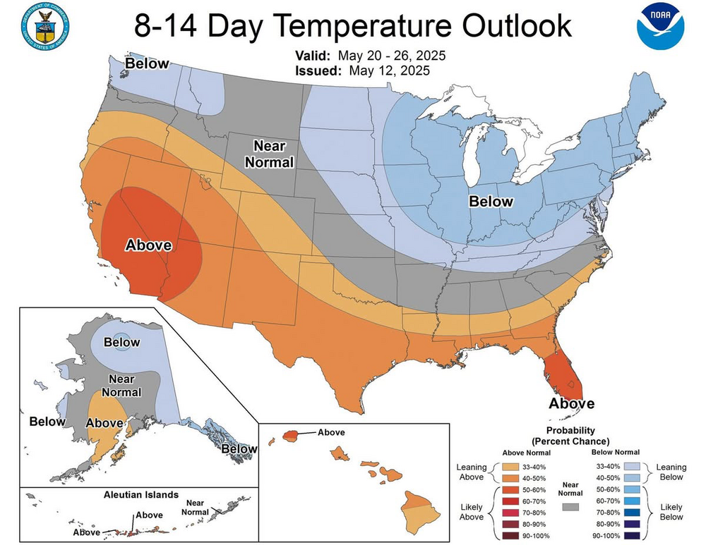
Initial Day 3 outlook was surprisingly underwhelming. Gun-shy after the one they put out for April 28? But this setup looks a lot more concerning simply from a trough geometry standpoint.
-
Just got back from dropping off the oldest for a 6 am set call time in downtown Frederick. Steady rain although looking at radar some heavier stuff looks to be headed up this way. 0.37” currently
- Today
-
Nice steady beneficial rain 0.36” so far
-
ya that would be perfect!
-
Looking at radar, looks like everyone should be cashing in this time. Most glad to see it loookg like that to start the day .
-
Nice! I’m only at .13” with steadier rain developing now.
-

Chester County PA - Analytical Battle of Actual vs. Altered Climate Data
chubbs replied to ChescoWx's topic in Climate Change
You aren't addressing my criticism. Yes, the new stations do a good job of covering the county, I never said they didn't. The problem is the older stations that make up the bulk of the county climate data. The older stations are located where people lived at the time: in towns, valleys, mainly in the east. We know the older stations are warm because when the Coatesville and West Chester stations moved a short distance to less built-up areas they cooled by roughly 2F. The DEOS stations that make up the bulk of your current station line-up are located in parks, nature preserves or similar, very different from the older coop stations. -
0.2-0.25” so far
-

Central PA Spring 2025
Mount Joy Snowman replied to canderson's topic in Upstate New York/Pennsylvania
Low of 62 with .06” of rain thus far. Off we go. -
.16 so far
-
Radar looks great for everyone. Finally a good soaker.
-
I made this... For my TV. There is more...