All Activity
- Past hour
-

Junorch obs and discussion 2026
Damage In Tolland replied to Damage In Tolland's topic in New England
Brrr .. Ass -
Looks like couple days next week could be downslope dandies, but otherwise 75-80. DSD days maybe 84-88. No dews. Meh.
-
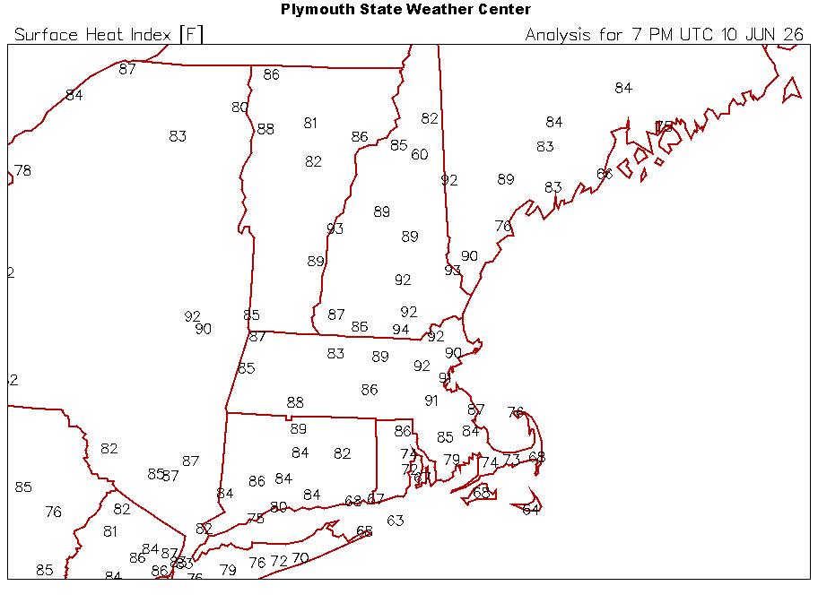
Deep summer with the heat and dews. 87.0/68
-
Station just went over an inch. Started the day with .41” and now at 1.02” and still raining.
-

E PA/NJ/DE Summer 2026 Obs/Discussion
JTA66 replied to PhiEaglesfan712's topic in Philadelphia Region
Junk & stuff bubbling up to our west. Will it hold? 80F/DP 72F -
Junorch obs and discussion 2026
Damage In Tolland replied to Damage In Tolland's topic in New England
They even tried to find some tweets to support these fallacies -
Numerous 70-90MPH wind reports in NE Iowa, NW Illinois and SW Wisconsin.
-

2026 Mid-Atlantic Severe Storm General Discussion
Eskimo Joe replied to Kmlwx's topic in Mid Atlantic
Outflow boundary evident on radar near Frederick. Looks like the storms lost the terrain boost that was keeping their updrafts going. Should see some more stuff fire up ahead of the main line here shortly? -
Dont even remember the last time it rained here, and the supposed rain today is drying up as it gets closer
-
they tried and tried. Using every chart known to man. bless their little hearts
-
I got a quick half inch from the line racing northeastward out of Iowa. The wind was gusty, but below severe.
-
Little cells popping up along 83, got cloudy quick
-
It is really dark here. Just got a lightning detection alert. Pouring rain.
-
2026 Mid-Atlantic Severe Storm General Discussion
Eskimo Joe replied to Kmlwx's topic in Mid Atlantic
Amazing to watch the soils just absorb the rainfall. -
its what the GFS showed.. but obviously didn't believe it
- Today
-
“Hoodies for days”
-
Mesoscale Discussion 1066 NWS Storm Prediction Center Norman OK 0100 PM CDT Wed Jun 10 2026 Areas affected...southern Wisconsin and northern Illinois Concerning...Severe Thunderstorm Watch 301... Valid 101800Z - 102000Z The severe weather threat for Severe Thunderstorm Watch 301 continues. SUMMARY...An arcing line of thunderstorms has organized in eastern Iowa and will move northeastward for the next few hours through WW 301. The threat for severe wind gusts is greatest in the delineated area as the system moves through. DISCUSSION...A line of severe thunderstorms has developed in eastern IA and is moving northeastward into southern WI and northern IL. A 64-kt wind gust was reported at 1740z in Dubuque, IA associated with this convection. Difluence aloft and low-level convergence along the leading edge of a ~10-F-deficit cold pool have likely contributed to storm strengthening during the last hour or so. Per current mesoanalysis, the line of storms is moving into a CAPE axis stretching from central IN northwestward into southeastern MN, featuring 2500+ J/kg along the WI/IL border. Bulk shear magnitudes are around 40 kts and southwesterly, oriented perpendicular to the convective line. This environment will support a threat for continued severe wind gusts as the system moves northeast for the next few hours.
-
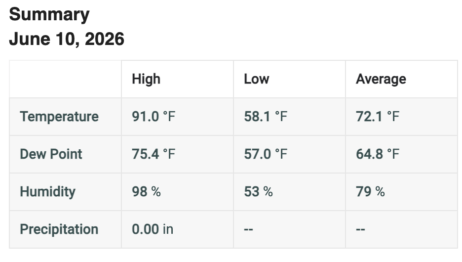
Definitely a warm one out there today!
-

2026 Mid-Atlantic Severe Storm General Discussion
wxmeddler replied to Kmlwx's topic in Mid Atlantic
3/4" of Rain in 15 Minutes at the Thurmont MD Mesonet site.- 469 replies
-
- 2
-

-
- severe
- thunderstorms
- (and 7 more)
-
you must have been drinking a bit to much last night to remember.. but I was saying that I expect 70s and comfortable dews..
-
-
Severe Sunday?
-
Classic humidity today (just got a swampy workout in) and another line moving thru with rumbles in the distance.
-
The 3 km NAM has a 100 kt 500 mb max tomorrow in IA, I cannot recall very many systems at all with that in June @RCNYILWX.
-
Ditty? Is that you?


.thumb.gif.f92b16c631a1d15d405ed77b33f0710d.gif)


