All Activity
- Past hour
-
102 at 1:42pm. For those of you in Raleigh and east, enjoy the rain.
-
Coming for ALEK job
-
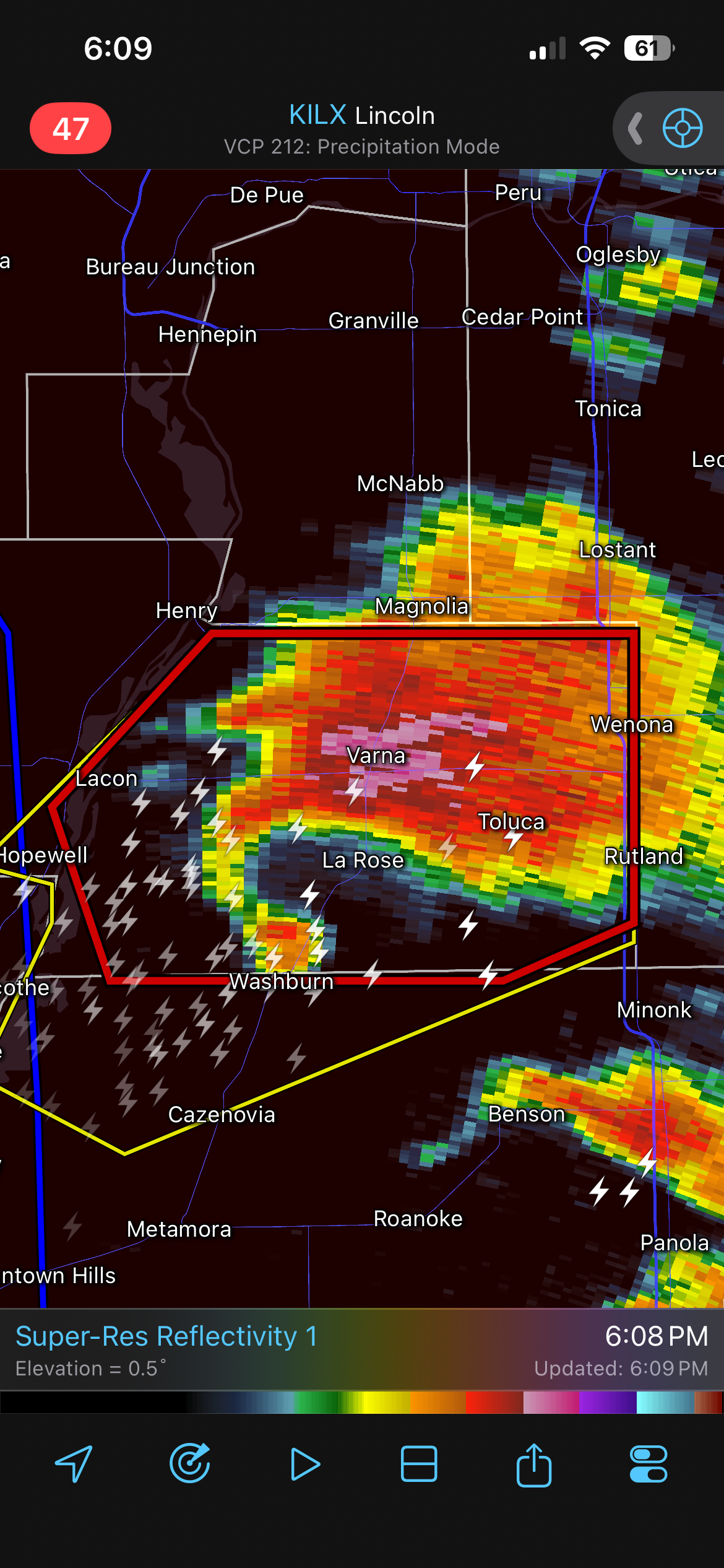
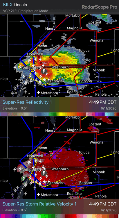
https://www.spc.noaa.gov/products/md/md1097.html Mesoscale Discussion 1097 NWS Storm Prediction Center Norman OK 0513 PM CDT Thu Jun 11 2026 Areas affected...portions of central into northeast Illinois Concerning...Tornado Watch 313... Valid 112213Z - 112315Z The severe weather threat for Tornado Watch 313 continues. SUMMARY...A strong tornado is likely ongoing across Woodford County, Illinois. The strong tornado threat from this storm is expected to continue for several more hours as it moves northeast. DISCUSSION...A debris ball has developed within a low-reflectivity hook west of Washburn, Illinois at 2205Z. This supercell is in a very favorable environment near the modifying outflow boundary across north-central Illinois. The KILX 21Z RAOB showed a very favorable environment with 0-500m SRH of 151 m2/s2. Recent VWP trends from ILX suggest this las likely increased within the past hour also. Given the continued northward movement of the outflow boundary and the discrete nature of this storm, expect an EF3+ tornado threat to continue for several more hours this evening as it moves east/northeast. ..Bentley/Smith.. 06/11/2026 ...Please see www.spc.noaa.gov for graphic product... ATTN...WFO...LOT...ILX...DVN... LAT...LON 40968956 41468879 41548810 41438778 41228773 40968813 40858889 40828939 40968956 MOST PROBABLE PEAK TORNADO INTENSITY...140-170 MPH MOST PROBABLE PEAK WIND GUST...65-80 MPH MOST PROBABLE PEAK HAIL SIZE...1.50-2.50 IN
-
GWDLT
-
Idk anything about the town of Toluca but it doesn't look good for them.
-
RDU officially recorded 101.
-
That’s cool. You, @MazooWeather and I should all get together for a chase.. Or lunch. Something. Would be a good time. Always appreciate both of your .02. We don’t have many on the west side of the mitten any more. @WestMichigan too. @sbnwx85is close enough to count too lol. Also… 21z HRRR completely tapped out. Hopefully we get upscale growth and enough LLJ to vent something over here later.
-
Which presumably means SPC expects that line to keep going. Lets goooooo
- 501 replies
-
- 1
-

-
- severe
- thunderstorms
- (and 7 more)
-
It’s like 200kt gtg
-
detached tornado debris signature and vortex signature west of Washburn IL
-
Watch coming shortly for Eastern Shore https://www.spc.noaa.gov/products/md/md1096.html
-
That’s a nasty debris ball.
-
Also, just looked at the radar…I did not expect that lol.
-
TORE now. Unbelievable.
-
TORE BULLETIN - EAS ACTIVATION REQUESTED Tornado Warning National Weather Service Lincoln IL 511 PM CDT Thu Jun 11 2026 ...TORNADO EMERGENCY FOR LA ROSE...TOLUCA...WENONA... The National Weather Service in Lincoln has issued a * Tornado Warning for... Eastern Marshall County in central Illinois... * Until 545 PM CDT. * At 510 PM CDT, a confirmed large and destructive tornado was observed over Washburn, or 8 miles southeast of Lacon, moving northeast at 40 mph. TORNADO EMERGENCY for LA ROSE...TOLUCA...WENONA. This is a PARTICULARLY DANGEROUS SITUATION. TAKE COVER NOW! HAZARD...Deadly tornado. SOURCE...Emergency management confirmed tornado. IMPACT...You are in a life-threatening situation. Flying debris may be deadly to those caught without shelter. Mobile homes will be destroyed. Considerable damage to homes, businesses, and vehicles is likely and complete destruction is possible. * Locations impacted include... Toluca, Wenona, Varna, and La Rose. This includes Interstate 39 between mile markers 29 and 40. PRECAUTIONARY/PREPAREDNESS ACTIONS... To repeat, a large, extremely dangerous and potentially deadly tornado is on the ground. To protect your life, TAKE COVER NOW! Move to an interior room on the lowest floor of a sturdy building. Avoid windows. If in a mobile home, a vehicle or outdoors, move to the closest substantial shelter and protect yourself from flying debris. A large and extremely dangerous tornado is on the ground. Take immediate tornado precautions. This is an emergency situation.
-
Let’s get it to the “windy” city
-
Is it spicy outside? Yes. But give me longer days and this weather over shorter days and the February glacier. Fruit season is in, too. Cantaloupe and watermelon have been slapping lately after a bit of a slow start.
-

2026 Mid-Atlantic Severe Storm General Discussion
batmanbrad replied to Kmlwx's topic in Mid Atlantic
so far the line of storms coming out of WV and western MD seems to be holding together pretty well - wondering what it will do when it comes over the mountains and hits the pea soup air over us right now. If it keeps moving quickly it'll hit before we completely lose sunlight... -
I just live here. I do have a met degree and used to storm chase a bit. I don’t pay for model data as much as others here, so I’m mostly in the same boat as you. I just have good weather intuition, usually. The mesoscale charts on the SPC page I find the most useful during severe weather. I know Michigan well because I grew up here.
-
Woah

-
But its not declared a TORE? Severe Weather Statement National Weather Service Lincoln IL 507 PM CDT Thu Jun 11 2026 ILC123-112245- /O.CON.KILX.TO.W.0087.000000T0000Z-260611T2245Z/ Marshall- 507 PM CDT Thu Jun 11 2026 ...A TORNADO WARNING REMAINS IN EFFECT UNTIL 545 PM CDT FOR EASTERN MARSHALL COUNTY... At 507 PM CDT, a confirmed large and extremely dangerous tornado was located over Washburn, or near Lacon, moving northeast at 40 mph. This is a PARTICULARLY DANGEROUS SITUATION. TAKE COVER NOW! HAZARD...Damaging tornado. SOURCE...Weather spotters confirmed tornado. IMPACT...You are in a life-threatening situation. Flying debris may be deadly to those caught without shelter. Mobile homes will be destroyed. Considerable damage to homes, businesses, and vehicles is likely and complete destruction is possible. The tornado will be near... Washburn around 510 PM CDT. Toluca and Varna around 515 PM CDT. Wenona around 525 PM CDT. Other locations impacted by this tornadic thunderstorm include Lake Wildwood, Marshall County Airport, and La Rose. This includes Interstate 39 between mile markers 31 and 40. PRECAUTIONARY/PREPAREDNESS ACTIONS... To repeat, a large, extremely dangerous and potentially deadly tornado is on the ground. To protect your life, TAKE COVER NOW! Move to a basement or an interior room on the lowest floor of a sturdy building. Avoid windows. If you are outdoors, in a mobile home, or in a vehicle, move to the closest substantial shelter and protect yourself from flying debris. A large and extremely dangerous tornado is on the ground. Take immediate tornado precautions. This is an emergency situation.
-
Topped out @ 95F today.
-

Central PA Summer 2026 Discussion/Obs Thread
WmsptWx replied to Voyager's topic in Upstate New York/Pennsylvania
Nice little storm rolling through the low end of Huntingdon county -

2026-2027 Super El Nino
snowman19 replied to Stormchaserchuck1's topic in Weather Forecasting and Discussion
-
Nice outflow boundary blew through. Nasty storms further out east.