All Activity
- Past hour
-
0.16” so far today, round 2 incoming
-
A moderate to significant rainfall is likely tomorrow into Tuesday. Much of the New York City area will likely see 0.50"-1.50" of rain. An area of 2.00"-3.00" rainfall with locally higher amounts is possible, especially north and west of New York City. No exceptional heat is likely through the first week of August. The ENSO Region 1+2 anomaly was +3.8°C and the Region 3.4 anomaly was +2.2°C for the week centered around July 23. For the past six weeks, the ENSO Region 1+2 anomaly has averaged +3.38°C and the ENSO Region 3.4 anomaly has averaged +1.92°C. The ongoing strong El Niño will continue to strengthen through the summer. The SOI was -7.77 today. The preliminary Arctic Oscillation (AO) was -0.297 today.
-

Central PA Summer 2026 Discussion/Obs Thread
canderson replied to Voyager's topic in Upstate New York/Pennsylvania
Close to .6” so far. We’ll see if that huge slog down near Baltimore gets here. -
Up to 3.12” on the day down here in Stafford 77/76
-

Augdewst 2026: Summer's Last Stand
Prismshine Productions replied to Prismshine Productions's topic in New England
Wtf already?! Sent from my SM-S176V using Tapatalk -
1.32'' so far today. Over 16'' in the last 35 days or so.
-

2026-2027 Super El Nino
jaxjagman replied to Stormchaserchuck1's topic in Weather Forecasting and Discussion
Typhoons in East Asia can definite cause unexpected pattern changes.But the problem is at least to me is there are two phoons while the strongest phoon is directed towards east China,the phoon is the WP actually to some extent counters the phoon headed towards China,you dont see no big height rises into the Koreas into Japan.The -NAO right now is just as well a player,heat should return in the plains along with the MJO moving into the MC,WP,this is MHO -

Central PA Summer 2026 Discussion/Obs Thread
Elim72 replied to Voyager's topic in Upstate New York/Pennsylvania
2.63 -

Augdewst 2026: Summer's Last Stand
CoastalWx replied to Prismshine Productions's topic in New England
That’s plenty of rain. -
 over the counter sildenafil: Generic Viagra online - Viagra tablet online
 -

E PA/NJ/DE Summer 2026 Obs/Discussion
JTA66 replied to PhiEaglesfan712's topic in Philadelphia Region
Despite the current look on radar, only virga here. -
 It's pretty fascinating thermal dynamics at play with Dolphin. The system remains in relatively low shear. It has already gone through numerous EWRCs. The typhoon has morphed from a deep, heavily banded system to one of multiple concentric rings that tend to hinder the core. Yet, shear should remain light. It will be moving across another degree Celsius or two of higher heat content. It will be interesting to see if Dolphin can reestablish enough intense core convection to tighten its gradient. It most likely will not reattain super typhoon status again. But it may have another period of strengthening. We shall see...
 -
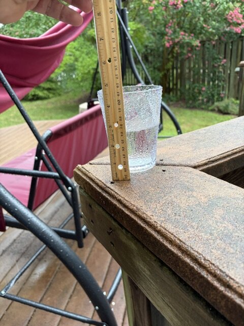
Hammered here in S. Arlington. This was from 4:30 to 5. Sorry for the unofficial reading. Still trying to get a "proper" rain gauge.
-
If this is the end of the Adley era in Baltimore it's been largely disappointing. They tanked for a lot of years for 2 seasons of competitive baseball and 0 post season wins. ( games) not series. Elias absolutely needs to be fired,but I get the feeling he will be back next year. Watching the little media availability that you do see Rubenstein do, it's starting feel like incompetence at the ownership level. All three levels of incompetence in the organization with Ownership, baseball ops and coaching. In 2023 they had the best record in baseball and the #1 ranked farm system to this in 3 years... Think about that.
-
Wasn’t totally cloudy yesterday or today thankfully. Patches of blue sky both days how much rain are we expecting? Torn on watering the tomatoes
-

2026-2027 Super El Nino
Terpeast replied to Stormchaserchuck1's topic in Weather Forecasting and Discussion
Likely has something to do with that warm blob south of the aleutians. Not a typical pattern in a growing el nino, but as the NH season cools, that blob should get slowly shunted east as the north pac jet strengthens. We’ve seen the PDO dive in the spring and summer, and then slowly climb in the fall and winter, time and again and this year probably will be no exception. We may even break positive this time with the super nino.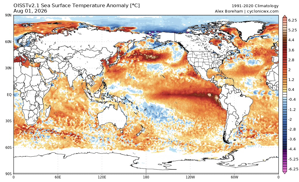
-
Yeah my station isn’t capturing the full amount for sure
-

Augdewst 2026: Summer's Last Stand
Supernovice replied to Prismshine Productions's topic in New England
Don’t give our resident moron the oxygen he needs. Just ignore his ‘weather related’ posts like everyone else and he will slowly….ever so slowly, go away. -
I had to leave town for it to finally rain. My station says 1.24”. Radar seems to think that there is upwards of 3” in spots between my house and DCA.
-
My July rain total is 6.75". My June-July rain total is 15.79".
-

2026-2027 Super El Nino
GaWx replied to Stormchaserchuck1's topic in Weather Forecasting and Discussion
The latest WCS daily PDO has fallen to -2.19, which is the lowest since way back on 8/29/25! This plunge was not predicted AFAIK: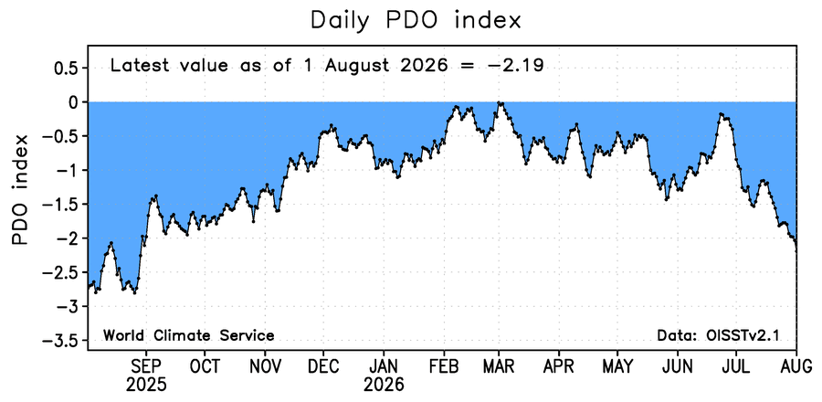
-
Touched 90 again today here in Phila. as well!
-
Feels like maybe Tuesday broke the seal for the city - getting slammed.
-
Thunder in Columbia with the start of this batch
-
Picked up .17" with this passing cell. Dew now at 81. I don't even want to take the garbage out.