All Activity
- Past hour
-
We’ve had what…. 1 fantasy run all season? When you can’t even buy snow on the long-range models in peak climo… remember when we were “setting the stage” with the Virginia snow in early Dec?
-
31 / 28 cloudy. Warmup commenced today with areas into the upper 30s - low 40s. 50s for many Wed - Thu and Fri ahead of a general 1 inch (ish) rainfaill Saturday. Beyond there near normal 1/12 - 1/16. Likely a back and forth below - near - above normal - tilted below beyond there 1/17 - beyond.
-

January 2026 regional war/obs/disco thread
Typhoon Tip replied to Baroclinic Zone's topic in New England
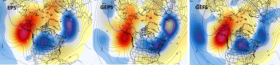
13-14-15 is still on the table. Altho probably favors the latter end of that range if there's going to be an event. Obviously we have nuisance to lower level advisory issues in the nearer terms, but writing in terms of more broadly supportive support for canonical events, which is beyond these foreground concerns. The 00z EPS/GEPs/ and even the typically hesitant GEFs still attempting amplitude along the OH-MA with +PNA arrival. Typical to find events in that spatial-temporal reordering of the super synopsis. Then beyond then ... ~ the 15th-18th, the hemisphere gets interesting. That +PNA lending to a bit of an H.A. signal appears slated to be a transient index state as it soon de-amplifies. However, changes in the forcing scheme upstream across the expanse of the Pacific lends to an original and new -EPO approaching the 20th. Quite amplified as of last night's means, too. No clue from this range what that will mean, but odds hugely sloped in favor a cold N/A loading period. Not a warm last 10 days of the month given the previous week's arrival into these 300+ hr mean structures...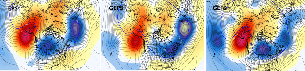
-
Warm wet, cold dry. We need the rain though.
-

January 2026 regional war/obs/disco thread
Lava Rock replied to Baroclinic Zone's topic in New England
understood and i feel mostly the same. wish we lived closer to the good stuff. -
WB 6Z EURO. Rainy period on tap for Friday-Sunday.
-

January 2026 Short/Medium Range Thread
Holston_River_Rambler replied to John1122's topic in Tennessee Valley
Y'all got any of them Rossby waves??? -

January 2026 regional war/obs/disco thread
jbenedet replied to Baroclinic Zone's topic in New England
I basically have two jobs. I’m in my key earning years. I love snowboarding, ice hockey and snow mobiling but I don’t live right in the mountains/country where it’s directly accessible. I’m here because I want those things *close*. Otherwise the weather that supports this stuff just makes life harder. Especially for my dog. -
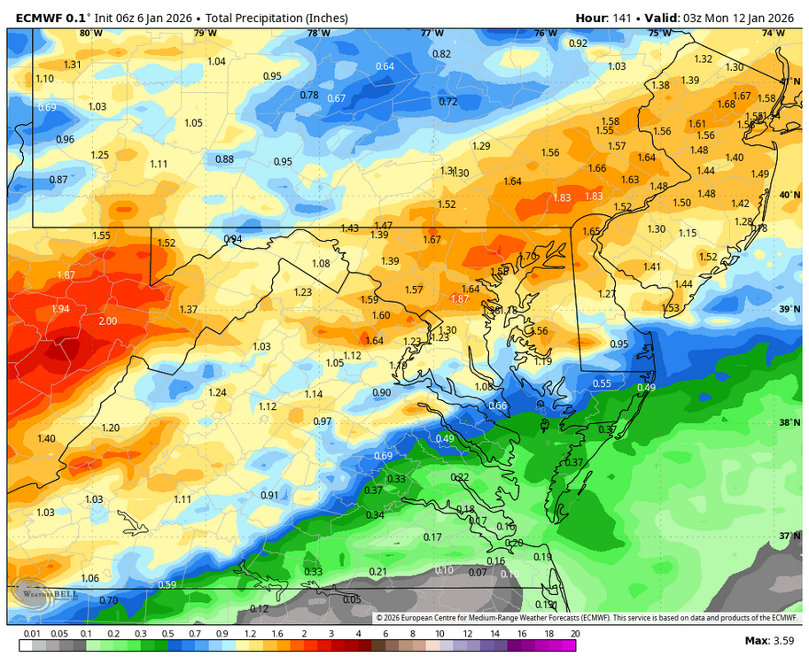
New thread for the new year for Saturday? @Kmlwx Day 4-8 Convective Outlook NWS Storm Prediction Center Norman OK 0400 AM CST Tue Jan 06 2026 Valid 091200Z - 141200Z ...DISCUSSION... ...D4/Friday: Lower MS Valley vicinity... A mid/upper-level shortwave trough initially over the southern Rockies is forecast to take on a positive tilt as it moves eastward on Friday, as a northern-stream shortwave trough digs from the Canadian Prairies toward the Upper Great Lakes. Some guidance has trended weaker and farther south with a surface low developing near the lower MS Valley by Friday evening, though a relatively large warm sector is still expected to be in place through most of the period. Scattered to widespread storm development is expected from parts of east TX into the lower MS Valley, with sufficient deep-layer shear for organized convection and some attendant severe threat. Some adjustments to the 15% area have been made, based on guidance trends regarding surface low placement and the northward extent of the favorable warm sector. ...D5/Saturday: Parts of the East... Uncertainty regarding the synoptic pattern increases by D5/Saturday, with varying solutions regarding the extent of mid/upper-level trough amplification across the eastern CONUS, and the strength of the related surface low. Guidance generally agrees that buoyancy will be limited across much of the warm sector on Saturday. However, any organized convection that develops Friday night may persist into Saturday morning across parts of the Southeast, with some potential for an isolated severe threat. Farther north, the strongest solutions (such as the 00Z deterministic ECMWF) depict notable intensification of low/midlevel flow from the Ohio Valley into the Mid Atlantic, which could result in some damaging-wind potential with any low-topped convection along or ahead of an advancing cold front. ..Dean.. 01/06/2026
- 1,377 replies
-
- 1
-

-
- severe
- thunderstorms
- (and 2 more)
-
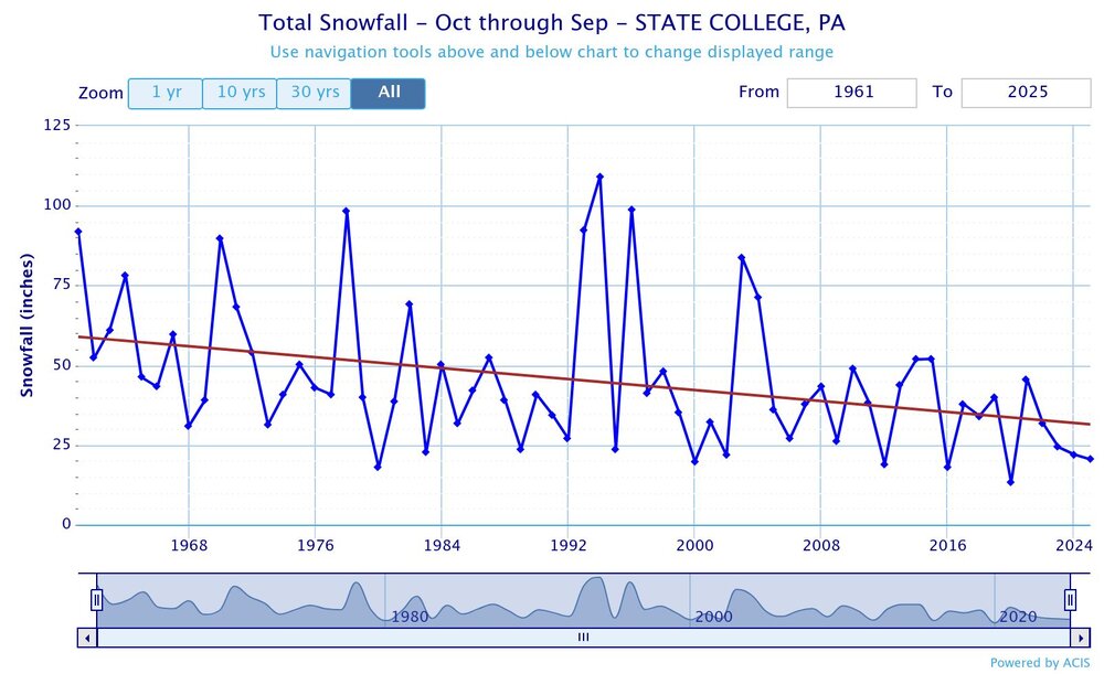
State College has seen one of the steepest snowfall declines in the Northeast since the 1960s when they lost the Miller A track just east of the Apps around 20 years ago.
-

2025-2026 ENSO
PhiEaglesfan712 replied to 40/70 Benchmark's topic in Weather Forecasting and Discussion
+5F above average or a Top 10 warmest month. Since 2015-16, that has happened at least once in the November-March period, except for 2018-19: 15-16 - November, December, March 16-17 - January, February 17-18 - February 18-19 - None 19-20 - January, February, March 20-21 - November 21-22 - December 22-23 - January, February 23-24 - December, March 24-25 - November, March -
-

Central PA Winter 25/26 Discussion and Obs
pasnownut replied to MAG5035's topic in Upstate New York/Pennsylvania
fwiw, looks like an extra day of thaw is being added on the backend of this weeks Jan thaw. Fropa now sunday. -
January 2026 Short/Medium Range Thread
Holston_River_Rambler replied to John1122's topic in Tennessee Valley
6z AIs are a flashback to the old biases of the old OP Euro and GFS. GFS is progressive and dry with the eastern US and the Euro got shortwaves stuck in the southwest. If the new bias of the current models holds true (feedback cutoffs over the west coast and baja), pretty good run of the 6z GFS too. Ensembles still suggest best opportunities start around the 15th. -
This is probably the first time that Western North America experienced such an extreme temperature difference during the month of December. https://bsky.app/profile/climatologist49.bsky.social/post/3mbnq36jn6c2y Climatologist49 @climatologist49.bsky.social Follow December 2025 temperature departure from normal for the U.S. and Canada. 12:41 AM · Jan 5, 2026 Everybody can
-
January 2026 regional war/obs/disco thread
Lava Rock replied to Baroclinic Zone's topic in New England
you say that like it's a bad thing. Maybe NNE isn't for you anymore. -
Central PA Winter 25/26 Discussion and Obs
pasnownut replied to MAG5035's topic in Upstate New York/Pennsylvania
his split flow is evident aoa 1/17 and beyond. Just like the wierd cold pattern we've been in, its about timing of two streams/vorts. At least the SS will be open for some business and cold will be a bit more stable and close by when needed. -

January 2026 regional war/obs/disco thread
dryslot replied to Baroclinic Zone's topic in New England
31.92" here on the season, Should get close to 34" or so after tonight. -
Central PA Winter 25/26 Discussion and Obs
pasnownut replied to MAG5035's topic in Upstate New York/Pennsylvania
Negative ghost rider. Specially up in your neck of the woods. i'd think SE of the mtns might get a few peeks, but w/ that SLP traversing to your north, I'd think you are socked in. -
Another foggy morning. Not sure if the cold makes it here anytime soon other than brief cool downs
-
The models actually trended worse overnight and most developed a SE Ridge... I wouldn't pay much attention to last night's GFS. It already switched up at 6Z
-
Happy 30th Anniversary
-
My station precip for 2025 was 33.96".... This was the driest on my record of 45 years. The two previous driest are 37.68" in 2001 and 38.26" in 2016.
-

January 2026 regional war/obs/disco thread
moneypitmike replied to Baroclinic Zone's topic in New England
Do your penance. -

E PA/NJ/DE Winter 2025-26 Obs/Discussion
Mikeymac5306 replied to LVblizzard's topic in Philadelphia Region
If somehow the coastal slows down and the cold air gets to it, we might be onto something but...