All Activity
- Past hour
-

October Comes Early: Late September Multi-Hazard Hybrid Storm
Brewbeer replied to WxWatcher007's topic in New England
old fashioned and behind the times? lol ! I might me a few years older than you, but I'm fairly certain based on what you've posted on these forums over the years that you are way more "old fashioned" and way more "behind the times" my thermo is one of those alcohol filled jobbers. Mercury is extremely toxic to anything alive and leaving a mercury filled thermometer exposed in the environment is a bad idea I don't have a weather station yet, but would like to get one. If I get one, I will site the sensors where they they belong; I sure won't mount the temp sensor next to the grill on my deck like yours. Torch ! -

2026-2027 Record-breaking El Nino
Terpeast replied to Stormchaserchuck1's topic in Weather Forecasting and Discussion
The PDO drop back is unfortunate. It’s now around where it was at this time last year, and there is still some time for the PDO to rise back up to near neutral once the marine heat wave area cools off with the season change. But I think +PDO territory is off the table, and the clock is ticking for us to even get back to neutral. -
I think they changed the forecast, as of last night today was forecasted to be mostly sunny. This morning was patchy fog and then partly sunny. Current forecast is now partly sunny.
-
Flying under the radar is the 1997 autumn. Early freeze, well above normal snows in November and December. I remember an approximately 4” event here 11/14 which had a little staying power. 12/23 was a legit snow bomb and then about 5 days later another one that was rainy here but snowed up north I think.
-
Mine is only partly sunny for here.
-
another mostly sunny forecast yet it's mostly cloudy
-
Please see here (link below). This is a rain track for us as it was inland for the majority of the storm. The noreaster we just had was off shore for the majority of the event. https://www.jdjweatherconsulting.com/dec-11-12-1992
-
Yeah. But since there are so many missing days some years, it’s not an accurate annual average temperature. The average only includes the days with actual data. Lake Harmony only has snowfall starting with 2020-2021 and no temperatures. Data for October 1, 2020 through May 31, 2021 Click column heading to sort ascending, click again to sort descending. LAKE HARMONY 2.4 WNW CoCoRaHS 77.4 PORTLAND 2.7 WNW CoCoRaHS 63.8 PALMERTON 5.8 ENE CoCoRaHS 59.3 ALLENTOWN LEHIGH VALLEY INTERNATIONAL AIRPORT WBAN 58.1 MACUNGIE 1 SW COOP 57.1 SCHNECKSVILLE 2.7 SW CoCoRaHS 51.7 SCHNECKSVILLE 1.7 ENE CoCoRaHS 51.3 JIM THORPE 1.1 NNE CoCoRaHS 50.8 LEHIGHTON 1SSW COOP 49.2
-

October Comes Early: Late September Multi-Hazard Hybrid Storm
Great Snow 1717 replied to WxWatcher007's topic in New England
100% correct! -

Mid-Long Range Discussion 2026
WinstonSalemArlington replied to BooneWX's topic in Southeastern States
-
Yeah once we get through Thurs/Fri I think we're good with temps/Dp for the season. But these low clouds need to go.
-

Septorcher 2026 Discussion - Endless Summer
weatherwiz replied to Damage In Tolland's topic in New England
Might take a bit to climb on Thursday but we'll definitely see lower 80's within the region. Some of the typical torch spots would have a shot for mid 80's but the warmest llvl temps may get in a bit too late. We probably see a big regional temp spike though between 2-4 PM -
Put me in a coma until Thanksgiving.
-
 https://apexmenmeds.shop/# ed pills for sale
 - Today
-

Strong Nor'Easter/Hybrid Storm Late September 2026
jm1220 replied to Rjay's topic in New York City Metro
My street is a disaster with twigs on it still and a street around the corner from me had no power for 2.5 days because of branches down on power lines. I definitely agree it was a disruptive storm. I just had power flicker a few times. A few years ago PSEG did a good job clearing branches away from power lines on my street after we had something similar happen with us so this time it probably saved us. -
I'd just assume worm-hole to Columbus Day weekend...or indigenous ass-parade, or whatever in the hell the libs call it these days. PS: It's Columbus Day.....he sailed the ocean blue-deal with it.
-

October Comes Early: Late September Multi-Hazard Hybrid Storm
dendrite replied to WxWatcher007's topic in New England
Get me some washed up kelp -
It’s actually sprinkling here and satellite loop looks like getting sun is gonna be a battle.
-

Strong Nor'Easter/Hybrid Storm Late September 2026
WestBabylonWeather replied to Rjay's topic in New York City Metro
Very memorable storm. I can’t remember the last time my entire property was covered in live tree branches and leaves. Quite the cleanup -
If we can switch to a more sunny days/crisp nights pattern I think it will pop. Definitely no lack of moisture.
-

Strong Nor'Easter/Hybrid Storm Late September 2026
wdrag replied to Rjay's topic in New York City Metro
I followed up on my initial posts tropical weather 9/21-23 and agree w the subsequent summaries here. My last on this... Well... it's done (not a subtropical storm but...big moderate, spotty major impacts with 2-8" of Rain I95 corridor, two surges of power outages (early Sat and early Sun), at least moderate CF and at least moderate dune damage). I sure hope everyone agrees it was VERY well modeled by the EPS/EC suite vs the United States GEFS back at least to 9/21..., a very good planner. Debris cleanup now. Will check back when we get some comparable headline extensive moderate or major impact coastal storms this winter. Helpful good posts. (I like how the 5H trough is repeating here in the east this fall---let's see if its cold enough to be dendrites). -
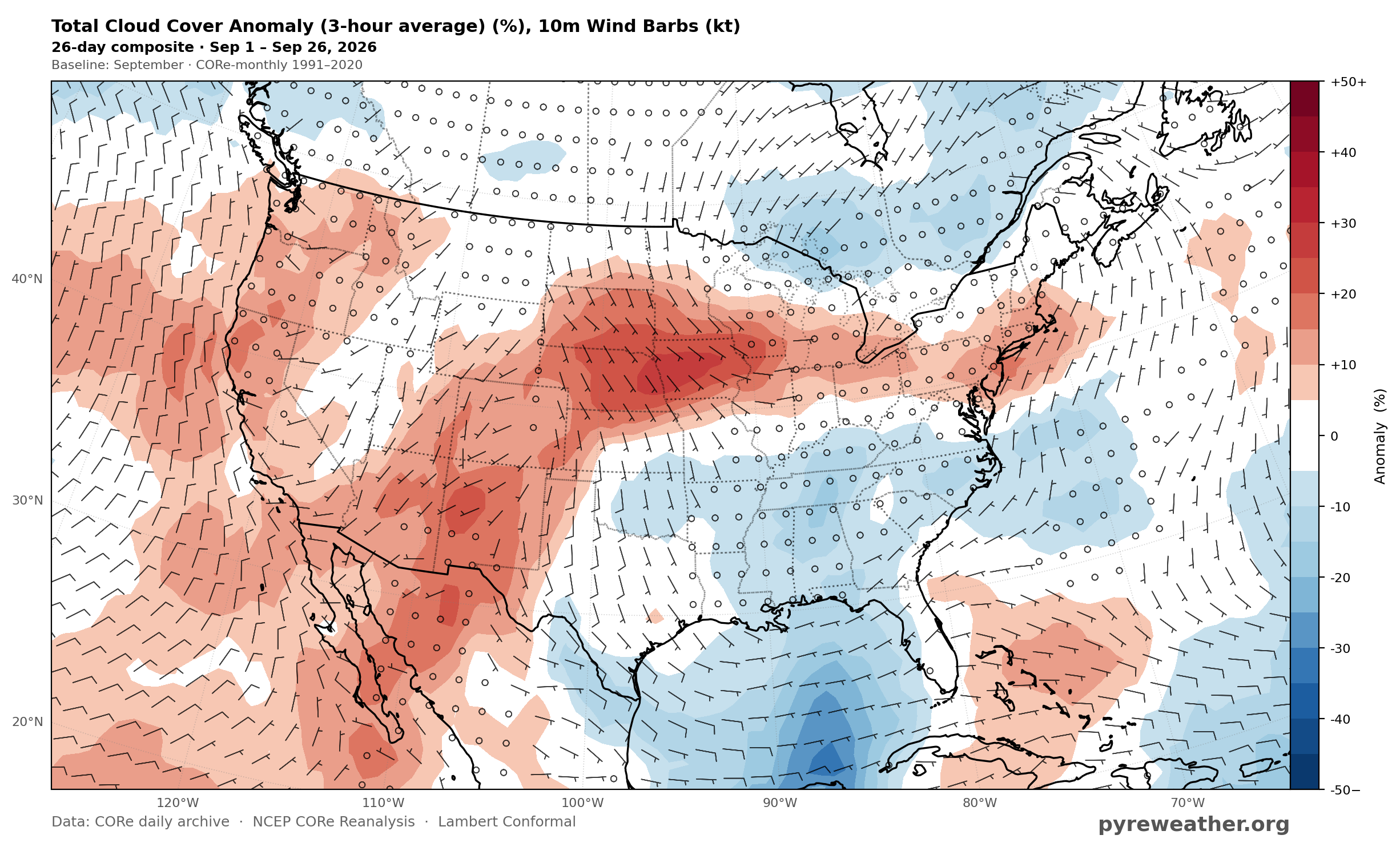
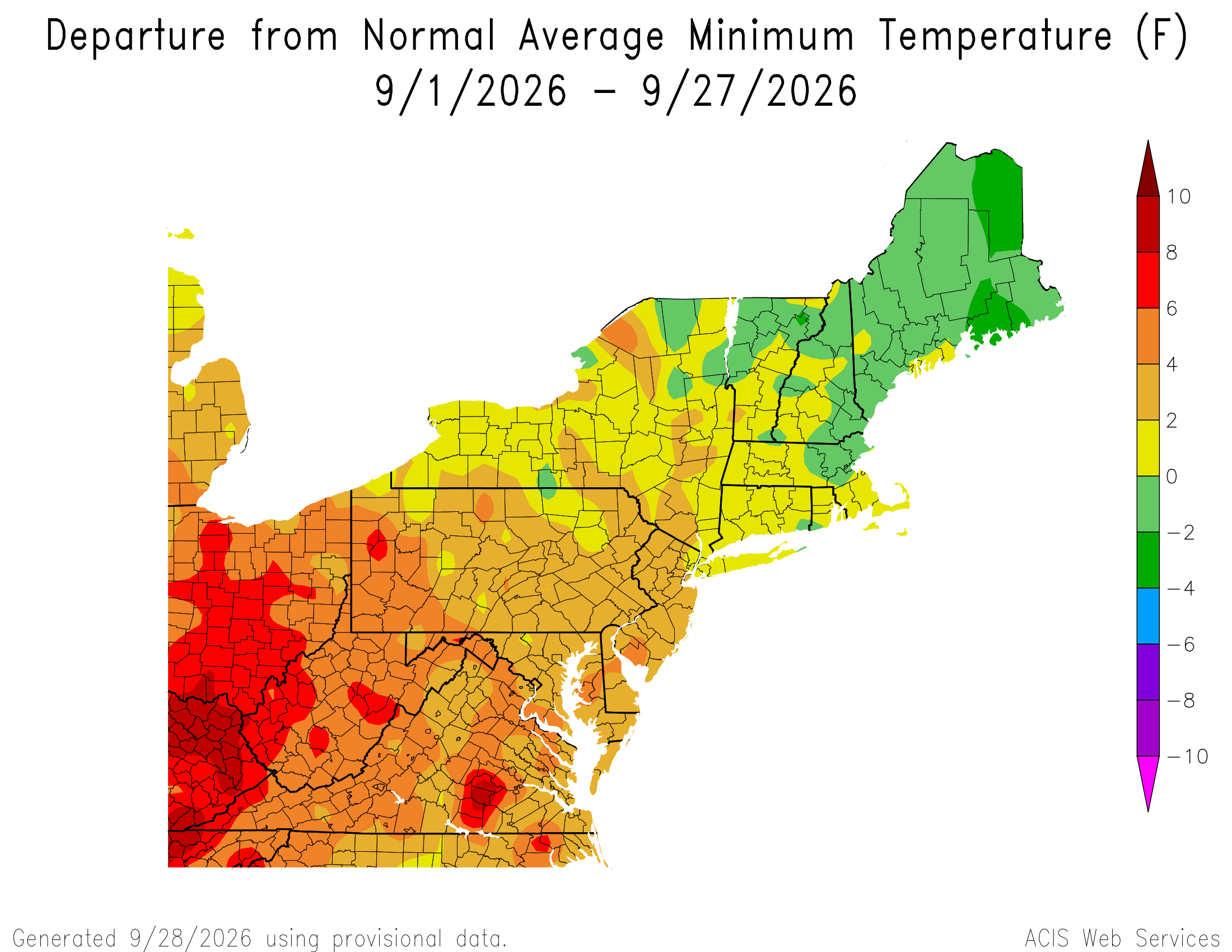
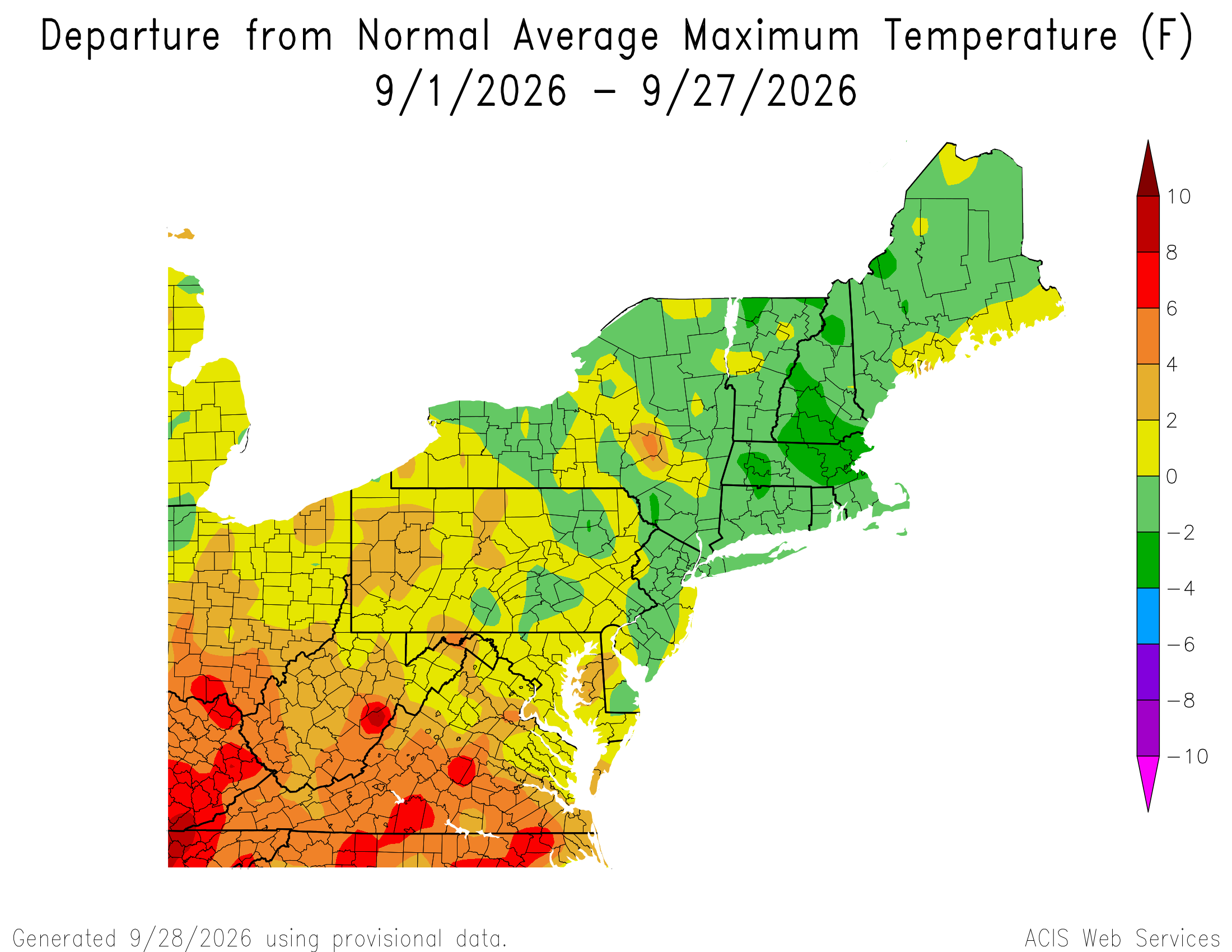
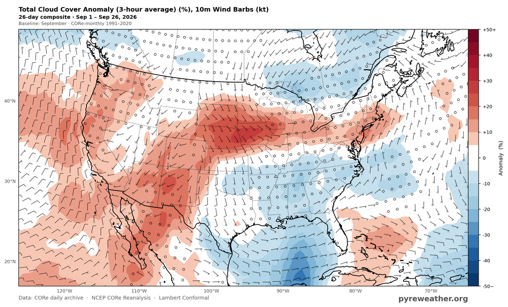
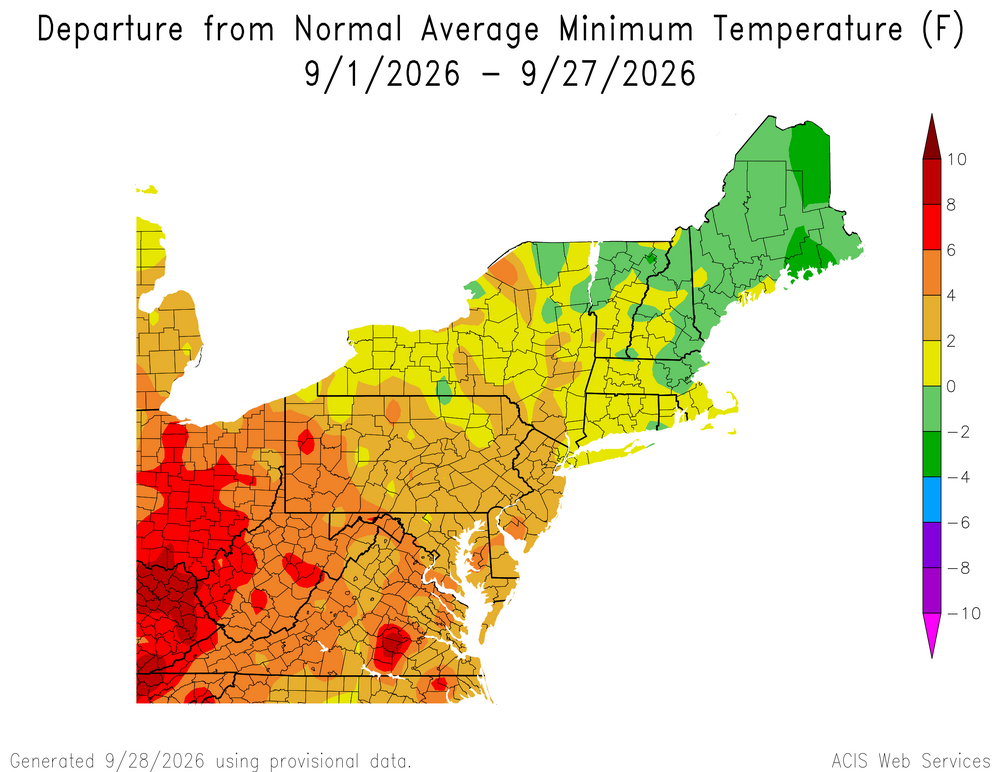
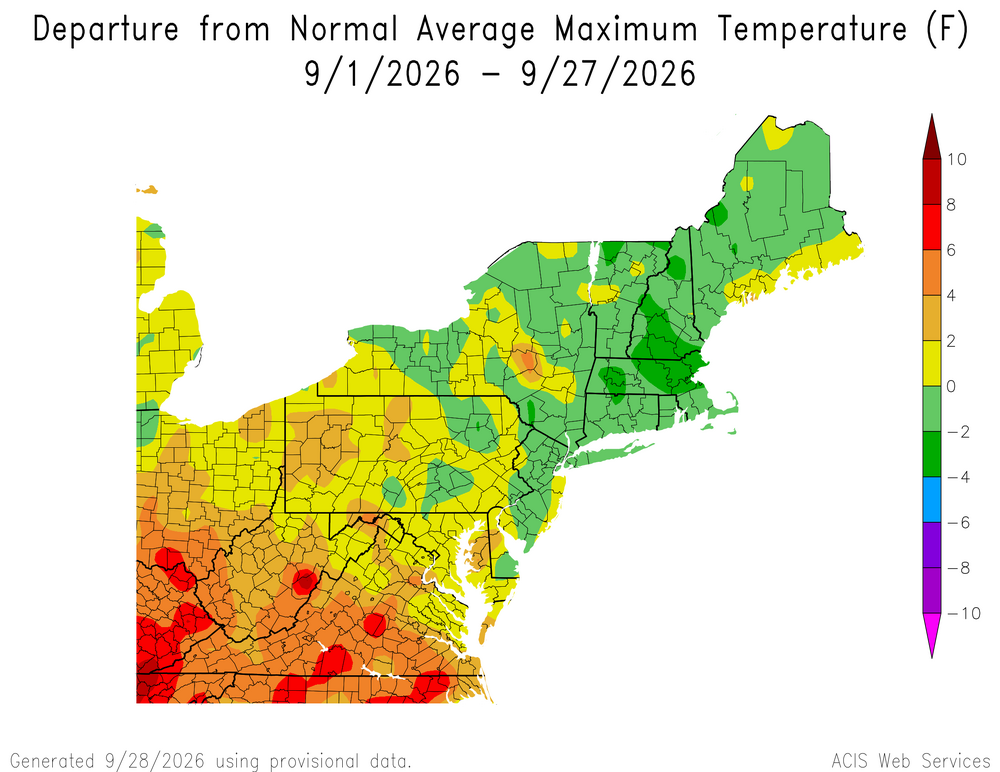
Wettest September on record for ISP. This was the 3rd consecutive month with part of the area recording 10”+ of rain. So plenty of clouds and onshore flow kept the minimum temperatures up and the maximums down. 10 Wettest Time Series Summary for ISLIP-LI MACARTHUR AP, NY - Month of Sep Click column heading to sort ascending, click again to sort descending. 1 2026 8.76 2 2 1966 7.50 0 3 2008 7.46 0 4 2023 6.78 0 5 1975 6.57 0 6 1996 6.41 0 7 2004 6.37 0 8 1974 5.95 0 9 1999 5.65 0 10 1978 5.56 0 Monthly Data for September 2026 for Upton NY NWS CWA Click column heading to sort ascending, click again to sort descending. CT NORTHFORD 0.8 SW CoCoRaHS 12.33 NY CENTEREACH 1.3 NE CoCoRaHS 10.70 NY SELDEN 1.6 ESE CoCoRaHS 10.67 CT DARIEN 2.4 NW CoCoRaHS 10.35 NY PORT JEFFERSON STATION 0.3 SSW CoCoRaHS 10.27 NY RIDGE 1.8 SE CoCoRaHS 10.18 CT JEWETT CITY 3.0 ESE CoCoRaHS 9.98 NY RIDGE 1.5 SE CoCoRaHS 9.97 CT TRUMBULL 2.6 SSE CoCoRaHS 9.67 NY SETAUKET-EAST SETAUKET 0.7 SSW CoCoRaHS 9.52 CT DURHAM 1.2 W CoCoRaHS 9.48 NY MOUNT SINAI COOP 9.37 CT STAMFORD 1.0 S CoCoRaHS 9.35 NY RIVERHEAD RESEARCH FARM COOP 9.32 CT DARIEN 3.6 N CoCoRaHS 9.31 CT NORWALK 2.9 NNW CoCoRaHS 9.30 CT WALLINGFORD CENTER 1.9 WNW CoCoRaHS 9.30 CT NORWALK 1.4 ENE CoCoRaHS 9.15 NY SHIRLEY 2.9 N CoCoRaHS 9.15 CT NORWICH 2.5 NNE CoCoRaHS 9.14 CT CHESTER CENTER 2.7 WNW CoCoRaHS 9.11 NY ISLIP TERRACE 1.1 NNE CoCoRaHS 9.05 NY MANORVILLE 1.8 SSE CoCoRaHS 8.99 CT NORWICH 5.4 SE CoCoRaHS 8.95 CT LEDYARD 0.5 NE CoCoRaHS 8.85 NJ WAYNE TWP 2.3 ESE CoCoRaHS 8.76 NY ISLIP-LI MACARTHUR AP WBAN 8.76
-
At 2.10" MTD we will finish yet another month well below normal in the rainfall department. In fact, we have finished BN in precip in 12 of the last 13 months at my location (comparing to RDU average monthly totals). Falls Lake which made a huge recovery after the record wet July has tanked and is now more than 5 feet below full pool. Kerr Lake has continued its fall and not sits more than 11 feet below full pool. The fall is typically when reservoirs are at their lowest but these levels are well below expected normals and will set us up poorly for next year unless the pattern changes for the region. I know El Nino SHOULD produce AN precip during the fall and winter across the area, we are at the point now where we need it to produce. Fingers crossed this weekend is the start of the change
-
Well... it's done (not a subtropical storm but...big moderate, spotty major impacts with 2-8" of Rain I95 corridor, two surges of power outages, at least moderate CF and at least moderate dune damage). I sure hope everyone agrees it was VERY well modeled by the EPS/EC suite vs the United States GEFS back at least to 9/21..., a very good planner. Debris cleanup now. Will check back when we get some comparable headline extensive moderate or major impact coastal storms this winter.
-
Yeah we should. Plenty of rain/no drought and temps haven't been too hot. Looks like a really great stretch after this week too. As long as it's not stormy we should have a great season