All Activity
- Past hour
-
 I don’t know what you want, man. It’s snowing. You’re probably going to get 4-5”. Would you rather bare ground? We all want a legit event, but this should have more appeal than a 1.5” clipper
 -
To me It’s interesting to see all these record breaking winter storms across the world the past few weeks. Juneau Alaska had a record month for snow, we all witnessed snow train that dumped on Mammoth in cali, a once in a decade winter storm in Japan last week, places in Russia where people are tunneling out of their houses to their cars due to excessive snowfall.
-

Winter 2025-26 Medium/Long Range Discussion
cyclone77 replied to michsnowfreak's topic in Lakes/Ohio Valley
CAD would be correct if it stood for cold and dusters. -

2025-2026 ENSO
TheClimateChanger replied to 40/70 Benchmark's topic in Weather Forecasting and Discussion
xMacis can sort by years, months or days, but that many days overwhelms it. If no more snow falls this month, the 120-month rolling total (ending 1/31) would be 75.6" at DC. The current record is 92.8" ending every month from March 31, 2025 to November 30, 2025. DC would need 17.2" to avoid a new record by month end rolling. Probably the same for the daily unless some additional snows fell in 2016 between the snowmaggedon and the end of the month. -
After a brief lull, light snow starting up again as radar continues to fill in.
-
Jan 30, 2010 was on the CIPS analog list @wxmvpete showed earlier
-
I remember discussions that your area was under 700mb lift normally found on the northern edge of precip shield if iirc correctly.
-
Snow will redevelop and then continue into tonight. By the time the storm departs, New York City and nearby areas will likely see a storm total 2"-4" of snow. Parts of interior southeastern New York State across Connecticut into southeastern New England will likely see 3"-6" on account of higher snow-liquid ratios. Some 8" amounts are possible in southeastern New England. Tomorrow will be brisk with highs in the lower 30s. Arctic air will move into the region on tomorrow night. Tuesday could be the coldest day so far this season with highs struggling to reach the lower 20s and lows in the teens in New York City. Suburban areas could see single-digit lows, especially on Wednesday morning. Wednesday will be another unseasonably cold day. Another shot of cold air could arrive Thursday or Friday, possibly with some snow flurries or snow showers. Temperatures will remain below normal through next week. After January 20th, conditions could become favorable for potentially larger snowfalls, as a generally cold pattern continues. The probability of a PNA+ regime has continued to increase. PNA-related developments would have large implications for snowfall. A persistently positive PNA would have above climatological risk of moderate or significant snowfalls. A mainly negative PNA would favor mainly small snowfalls. The ENSO Region 1+2 anomaly was -0.7°C and the Region 3.4 anomaly was -0.8°C for the week centered around January 7. For the past six weeks, the ENSO Region 1+2 anomaly has averaged -0.47°C and the ENSO Region 3.4 anomaly has averaged -0.67°C. La Niña conditions will likely continue into at least late winter. The SOI was +22.15 today. The preliminary Arctic Oscillation (AO) was -0.660 today. The PNA was +1.107. That's the highest value since November 1, 2025 when the PNA was +1.698.The last time the PNA was at least this high on January 18th was 2014 when the PNA was +1.263. Based on sensitivity analysis applied to the latest guidance, there is an implied near 85% probability that New York City will have a cooler than normal January (1991-2020 normal). January will likely finish with a mean temperature near 32.0° (-1.7° below normal). Supplemental Information: The projected mean would be 0.6° below the 1981-2010 normal monthly value.
-
I drove to my parents' place in Calvert as they were expecting 8-10 while Germantown was looking at an inch or two. They got 8 and Germantown got 7 LOL
-
I only look at the HRRR during an event
-
Wait until Saturday, you will be begging for it to stop.
-
Not surprised that Feb 96 was one.
-
Seems like BAM and a few others aren’t buying the southern shift for next weekend and think it’ll be more of a southern Great Lakes/Ohio Valley system. Up until those 12z runs I definitely thought the same, that next weekend would largely be north of us and a stage setter for multiple chances in the week that follows.
-

Pittsburgh/Western PA WINTER ‘25/‘26
colonel717 replied to Burghblizz's topic in Upstate New York/Pennsylvania
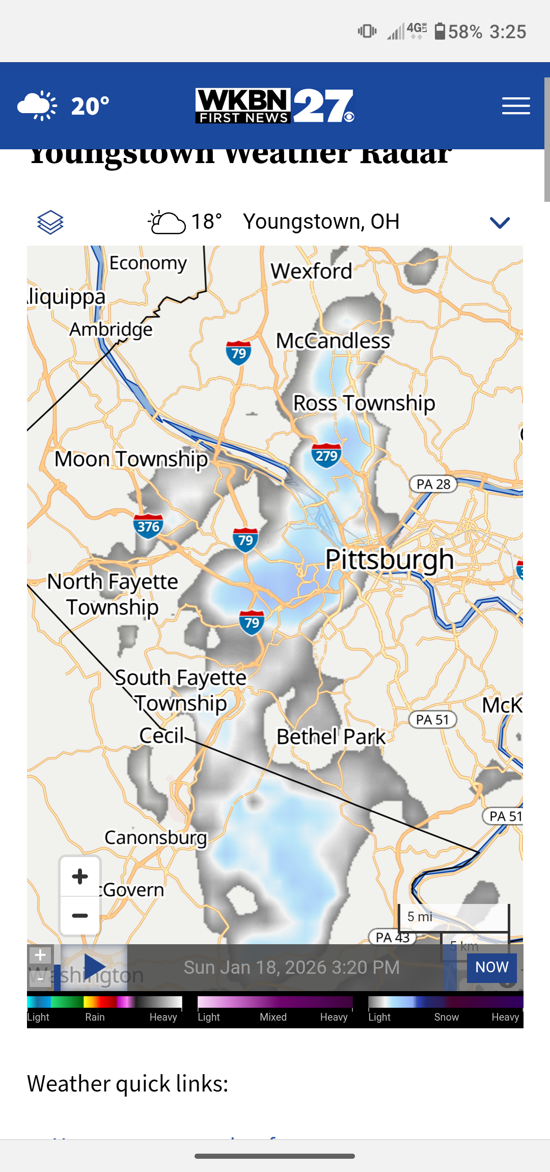
I've been out in North Hills area near Ross Park mall, getting heavy squall.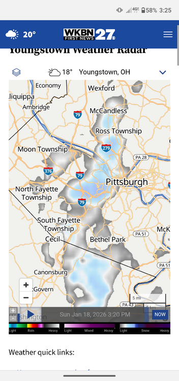
-

Storm potential January 17th-18th
SnoSki14 replied to WeatherGeek2025's topic in New York City Metro
This is a nowcasting situation now. I've stopped looking at models -
Sorry ass light to moderate snow
-

Storm potential January 17th-18th
wthrmn654 replied to WeatherGeek2025's topic in New York City Metro
Montauk is 33 right now -
Genuinely the heaviest show I’ve gotten all year what the hell.
-
Nice,top anolog is 2024 https://www.weather.gov/ohx/20240114
-

Storm potential January 17th-18th
coastalplainsnowman replied to WeatherGeek2025's topic in New York City Metro
For anyone who cares, from a snow standpoint this playoff game in Foxboro could be fun to watch toward the end. -
It’s still snowing nicely. Snow on ground. Why are people complaining
-

Richmond Metro/Hampton Roads Area Discussion
wasnow215 replied to RIC Airport's topic in Mid Atlantic
Euro about to win again-big time. Even with the changeover happening now, the precip will be out of the region very soon. And man oh man it sure has a pretty snow storm on 12z for our region for next weekend! -

Storm potential January 17th-18th
BoulderWX replied to WeatherGeek2025's topic in New York City Metro
Just enjoy whatever falls as this point. We’ve had snow falling for most of the last two days and people will see a total not anywhere between 3-6” for the two days. Great couple of events. -
Day 6-10 CPC analogs: 20240118 20030123 20110113 20210210 20070207 19960202 20030114 20140208 20100130 20170204 Day 8-14 CPC analogs: 20030125 20160211 20160117 20100215 19950205 20030112 20070213 19950128 19960211 20060209
-
All rain at Wake Forest Rd @ 440