All Activity
- Past hour
-
No clue why some idiots are giving me weenies when the pattern supports an amplified solution. Storms can pop out of no where in this pattern.
-
Not saying it will happen, but with this pattern I've been waiting for something like rlthis.
-
Okay well the GFS has countered with its own subsequent event… I want both
-
It just looks so simple, right? Not waiting for phasing, this and that needs to go right before snow starts falling type deal....just some energy passing to our south and cold air in place.
-
GFS likes Sunday for a northern stream snow event for us.
-

E PA/NJ/DE Winter 2025-26 Obs/Discussion
Duca892 replied to LVblizzard's topic in Philadelphia Region
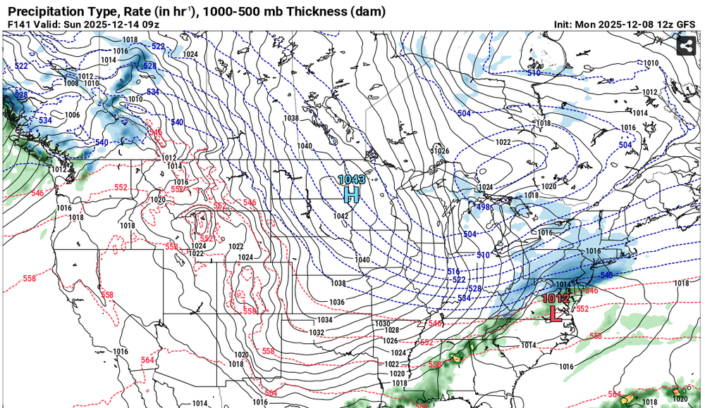
GFS has something interesting for next Sunday -
-
Mix of rain and snow on I85 south of Oxford
-
Rates starting to pick up. Measured 1.75" just now. Thus far it has been a pretty wet snow.
-
Gfs snowstorm this weekend Euro was also amplified at 6z. Aifs was also a hit.
-

December 2025 regional war/obs/disco thread
brooklynwx99 replied to Torch Tiger's topic in New England
nice Arctic wave. seeing the PNA get a bit better is a plus
-
Little something something on the gfs for the 14th.
-
All snow now in Lewisville
-
Challenge level: 10/10 Id kill for a good Miller B style storm right now. Give me that front end thump followed by a sleet fest to ensure it doesn’t melt for a week. A 2022 repeat would heal my soul.
-
-
Temp down to 36. More wet snow mixing in.
-
Toss this, not possible. I hear it only snows in the South anymore.
-

December 2025 regional war/obs/disco thread
weatherwiz replied to Torch Tiger's topic in New England
Our only hope of amplifying the ridge across the West for that mid-month period is if it connects with the ridging over Alaska. But dating back to even the last few years, we have seen countless times models in the extended range want to develop these beautiful ridges in the West only for it to either not verify, or its duration was too short to have any meaningful influence downstream. Something has to change within the background state for this to actually happen, not just "the EPS wants to do this at xxxx time"). It's pretty unfortunate but the pattern is setup to favor weak clippers and shredded garbage. But for some reason...it must be something within the model physics we keep seeing these tendencies to overamplify things within a specific time range (and I even fell for this with last nights potential). But people will keep falling for it and trying to come up with ways to justify as to why "it needs to be watched". -
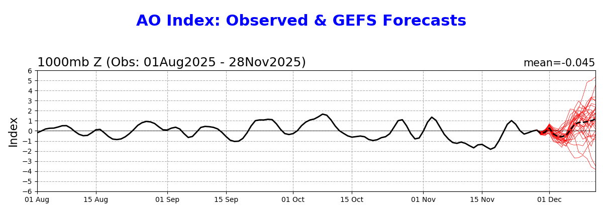
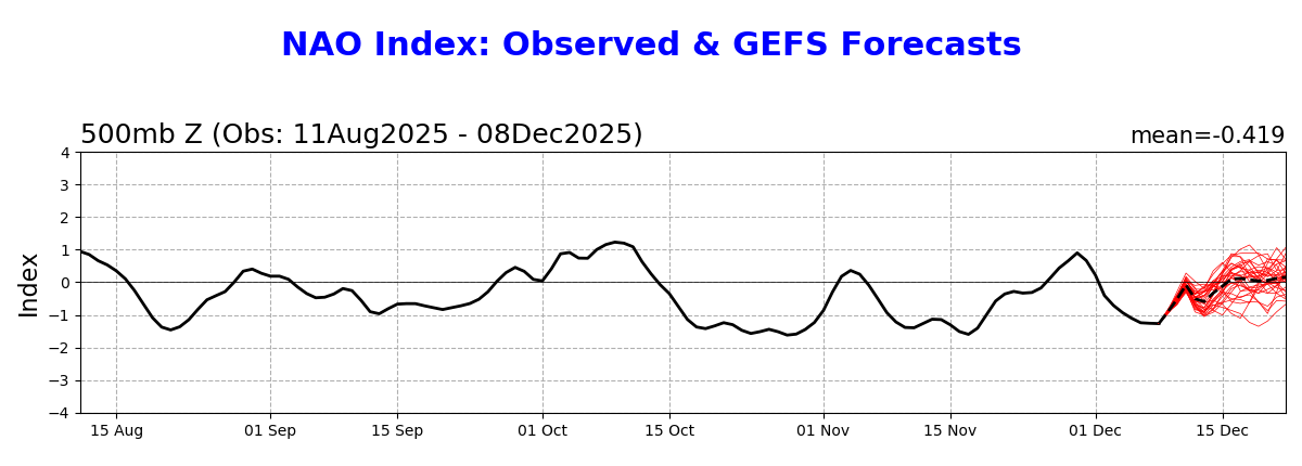
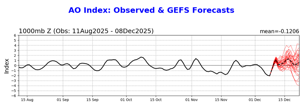
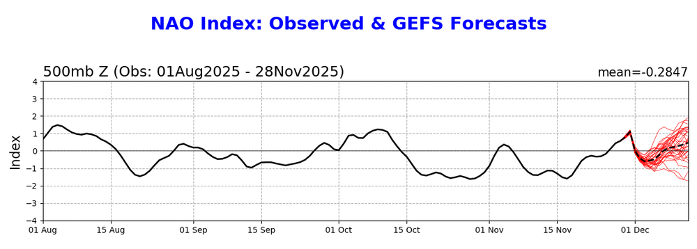
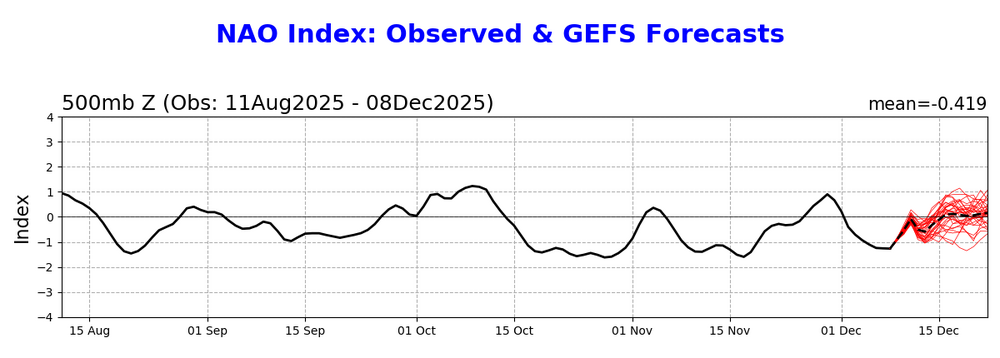
A big reason the models have been much too warm in the E US are the horrible NAO/AO progs with this one from just 11 days ago having it go + just 1 week later: 11/28 AO prog for today: ~+1 Today’s AO verified way down at ~-2 (strong -AO) meaning a +3 miss: There was a similar big miss for the NAO: 11/28 NAO prog for today slightly positive (~+0.2): Today’s NAO verified way down at -1.2 (strong -NAO), meaning a +1.4 miss:

-
And so? Who am I hurting? Nobody. Did I insult anybody? Offend anybody? Yeah I'll keep working on it for the sake of board discussion...but is it really that important in the grand scheme of things? You act like I'm somehow some disgusting person because of it. All you have to do is put me on ignore. I'm curious as to why you don't...and I'm sure you won't answer that, lol
-
and what is interesting about that, is why? Why so triggered about someone like her?
-
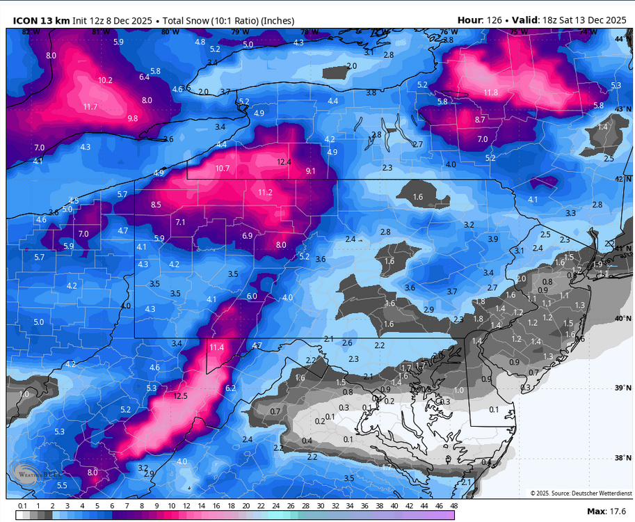
Honestly feels good to have the icon show it - it seems like it’s always the first model of the cycle to show a whiff/be bone dry.
-
We got some time unlike whatever small north trend happened on today’s VA storm
-
What is it going to take for us to get a strong CAD like the old days?
-
(002).thumb.png.6e3d9d46bca5fe41aab7a74871dd8af8.png)
E PA/NJ/DE Winter 2025-26 Obs/Discussion
ChescoWx replied to LVblizzard's topic in Philadelphia Region
The "trusty" ICON model highlight our next 2 winter "events" the first on Wednesday and the next on Friday night....