All Activity
- Past hour
-

Richmond Metro/Hampton Roads Area Discussion
chris624wx replied to RIC Airport's topic in Mid Atlantic
More hours before changing over. And no hours with rain. But alas. -

Central PA Winter 25/26 Discussion and Obs
Itstrainingtime replied to MAG5035's topic in Upstate New York/Pennsylvania
Thanks for all of the updates, guys! Living vicariously through you from Ft. Lauderdale where it's currently 71/58. Off to Miami tomorrow morning. -
Same result? I know you're trolling but man, that GFS run is substantially better for the forum as a whole. And no, I'm not just saying that because I happen to be on the right side of this pixel

-

-

Pittsburgh/Western PA WINTER ‘25/‘26
TimB replied to Burghblizz's topic in Upstate New York/Pennsylvania
I would expect to wake up to a winter storm watch unless the euro instills any doubts. -

Central PA Winter 25/26 Discussion and Obs
MAG5035 replied to MAG5035's topic in Upstate New York/Pennsylvania
They can keep that data coming haha. It doesn’t get much better than that for a well timed and positioned handoff to the coastal low to put PA in the best snows. -
Oh I agree its a 90% plus likelihood but I think a pathway exists when we have such complex interactions for the models to shift some more. Once again I think all synoptic stuff is settled by tomorrow 12z (which is why I'll make my final analysis then)
-

January 25/26 Jimbo Back Surgery Storm
Blacksburg Coach replied to Jimbo!'s topic in Southeastern States
Did you ask it to calculate with the following 7 days in the single digits!! -
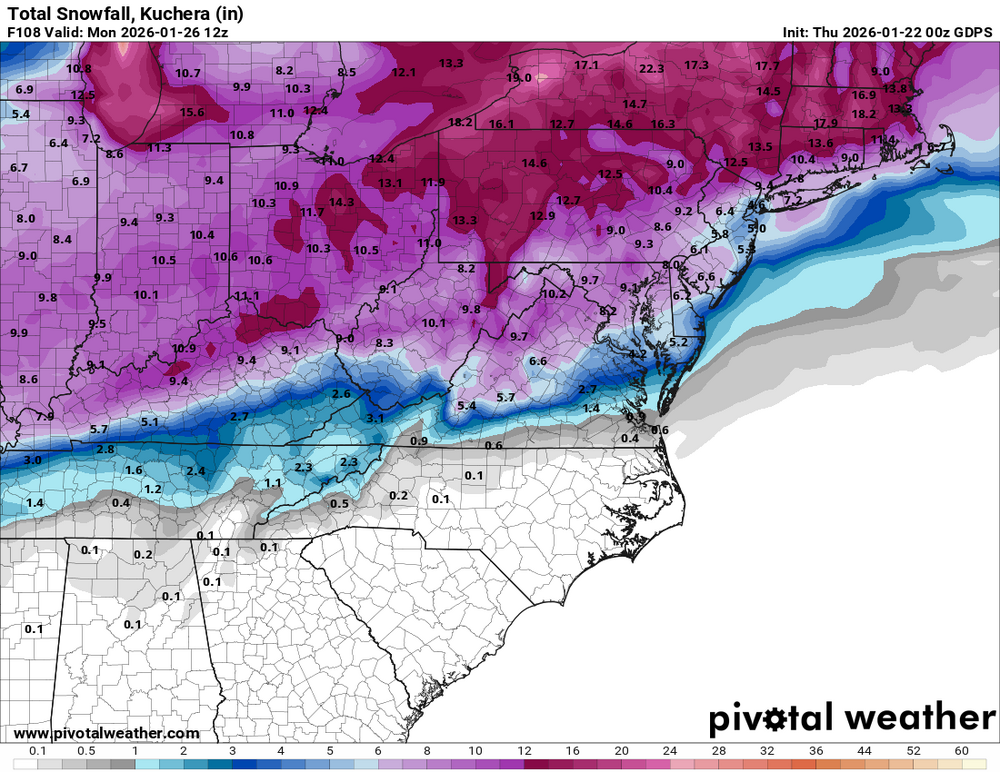
 0Z CMC probably the ugliest run I've seen so far for NYC/LI in the last 2 days of runs.
 -

Possible Record Breaking Cold + Snow Sunday 1/25 - Tuesday 1/27
Franklin0529 replied to TriPol's topic in New York City Metro
Yup did a good job here last week -

Pittsburgh/Western PA WINTER ‘25/‘26
colonel717 replied to Burghblizz's topic in Upstate New York/Pennsylvania
What a steal to get him. Big time talent. -

Possible Record Breaking Cold + Snow Sunday 1/25 - Tuesday 1/27
MJO812 replied to TriPol's topic in New York City Metro
.thumb.png.7216c82ef2af670afd10b424ba8cca9d.png)
-
Yes, amazing to see with that secondary LP.
-

Pittsburgh/Western PA WINTER ‘25/‘26
Mailman replied to Burghblizz's topic in Upstate New York/Pennsylvania
-
That gfs run was like a naming. Insane
-
Yeah, it won with this storm. It has consistently been the most amped and saw the second NS phase before any other model did. My post way back on Monday analyzing this storm put the CMC in its separate category where I bemoaned how if it pulled of this phase we'd mix. Well, it was right.
-
Knoxville has 24 hours of frozen precip according to the WxBell algorithm. Hour 69-83. Hour 78-93 is ice. Debatable whether that run would actually flip Knoxville rain just knowing how ZR behaves there from experience. Having done the ice deal in Knoxville during the eary 90s(surprise ice storm that hit right as school started on maybe a Friday)....Knoxville can get stuck at freezing sometimes. Either way...quick thump of snow, sleet, zr, and then rain for Knox. Right around an inch of ZR for TYS and .60-.70 for TRI w/ TRI managing 2" on the front end, then zr, then wrap around snow to end w 6"...doubt that snow total holds. North Georgia gets 2.44" of ZR. SW TN gets the sleet hammer. Chattanooga 1.11" of ice.
-
I think it's unavoidable at this point. Even our best case GFS has some sleet in there. I think it's a given. It's tough to hear, but at this point, I think we are looking to mitigate. GFS would be a wonderful solution if we absolutely had to deal with sleet.
-

January 25-26 Winter Storm Potential
The Iceman replied to Ralph Wiggum's topic in Philadelphia Region
It’s way weaker with the high pressure and weakens it significantly more than the GFS that’s a big difference. -

MO/KS/AR/OK 2025-2026 Winter Discussion
The Waterboy replied to stormdragonwx's topic in Central/Western States
I was just thinking the same thing. The NAM has spit out some stupid stuff throughout the years but this is a whole new level. A foot in many places seems quite feasible. -
CMC gets sleet all the way up to Boston this run... sheesh
-

Possible Record Breaking Cold + Snow Sunday 1/25 - Tuesday 1/27
Rjay replied to TriPol's topic in New York City Metro
If the synoptic evolution remains similar the next couple of days then I will really start to look at the nam to see the real story on the mid-level warmth. It's basically the only thing the nam is good for. -

Possible Record Breaking Cold + Snow Sunday 1/25 - Tuesday 1/27
SACRUS replied to TriPol's topic in New York City Metro
GGEM -
Yeah it's hard to pull for normal liquid rain but given a choice I'll take the warmest run of the Euro over that GFS run. Sent from my Pixel 10 Pro XL using Tapatalk
-

January 25/26 Jimbo Back Surgery Storm
Thrasher Fan replied to Jimbo!'s topic in Southeastern States
0z GFS slightly strengthened the blocking thus the CAD was a bit stronger that run.


.png.e6329794b2f0a3bb723769380c2414e0.png)


