All Activity
- Past hour
-
 Thanks Walt, great write up
 -
Just as last year, they keep getting colder as we approach the forecast period. I'll take that as a positive at this point.
-
Do you guys remember this crazy game? I believe the Broncos broke a record for scoring in 2013.
-

Spooky Season (October Disco Thread)
Hailstoned replied to Prismshine Productions's topic in New England
No cure for bone spur fever. -
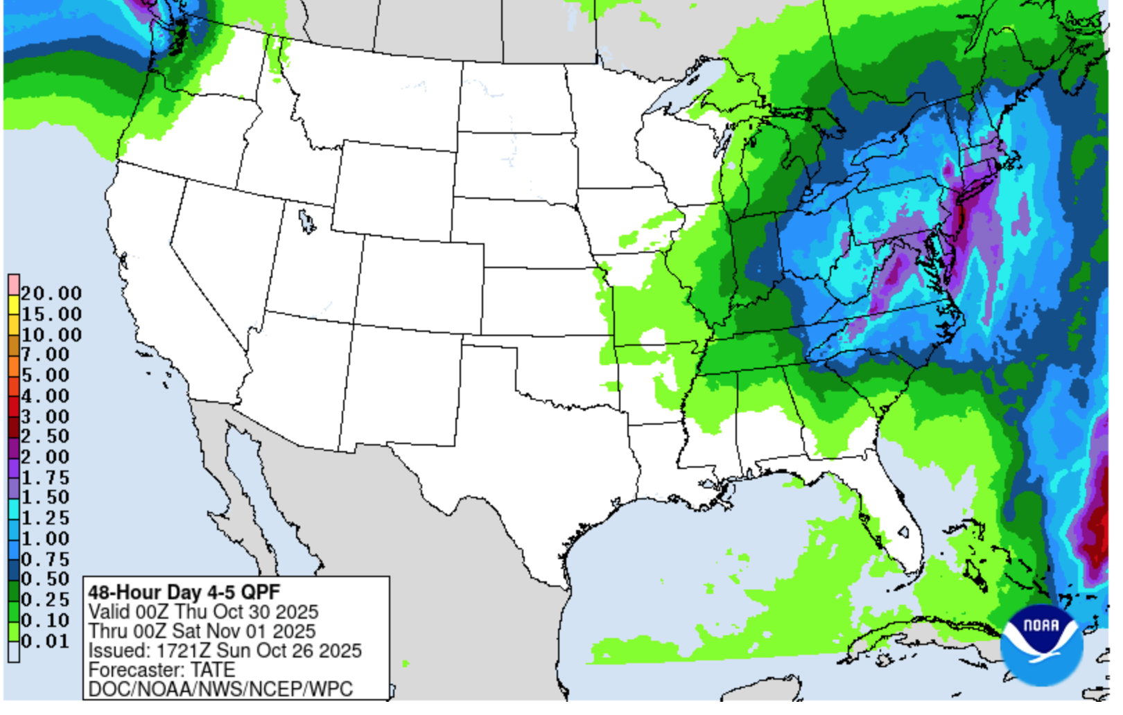
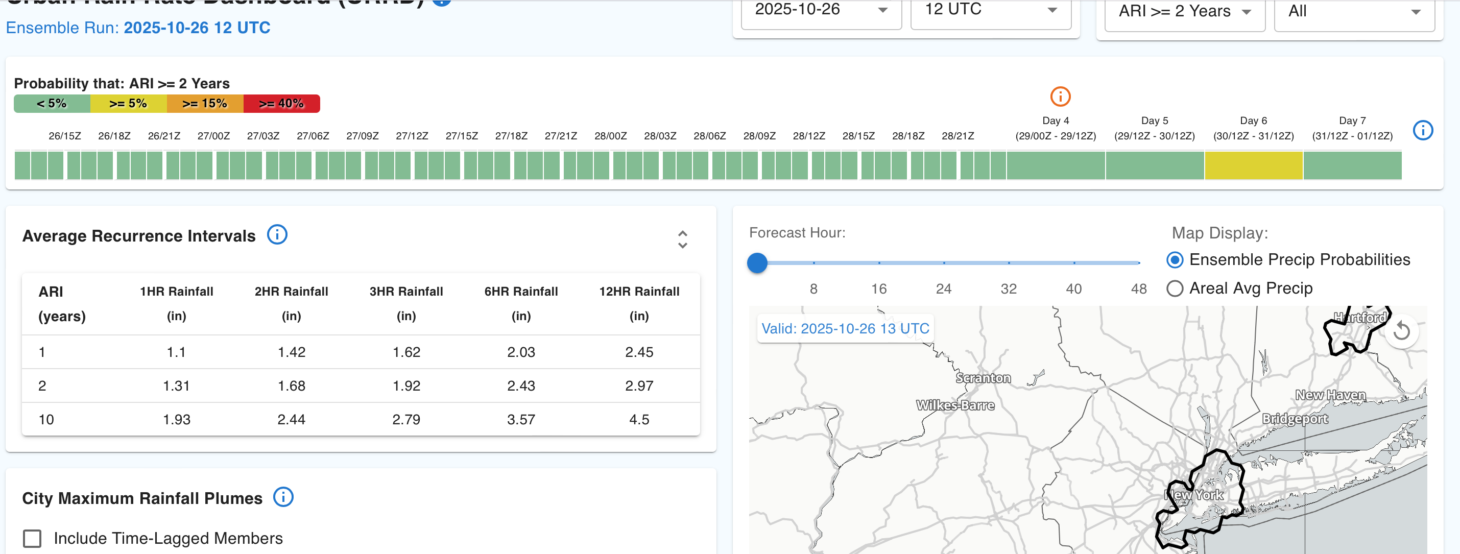
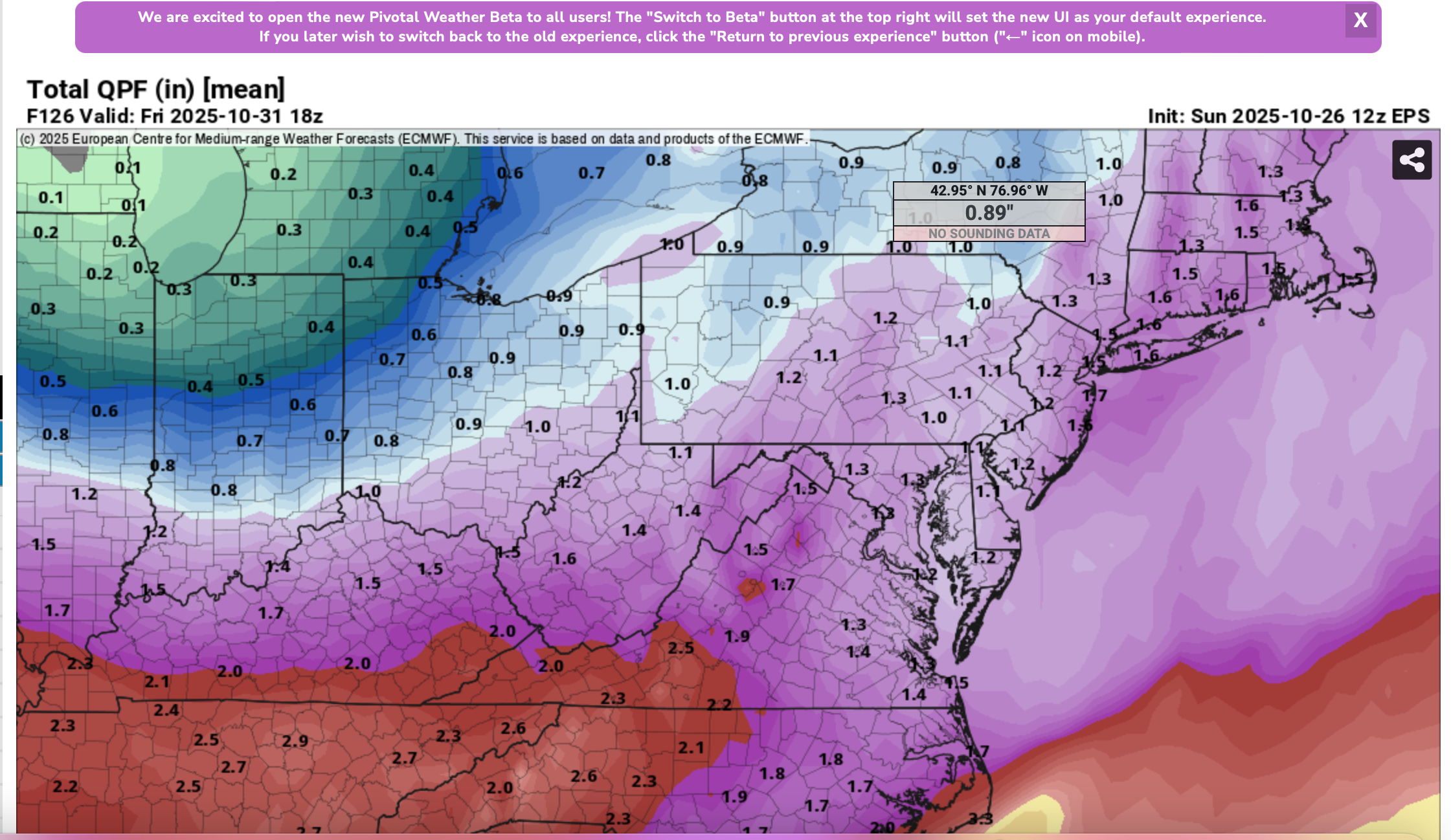
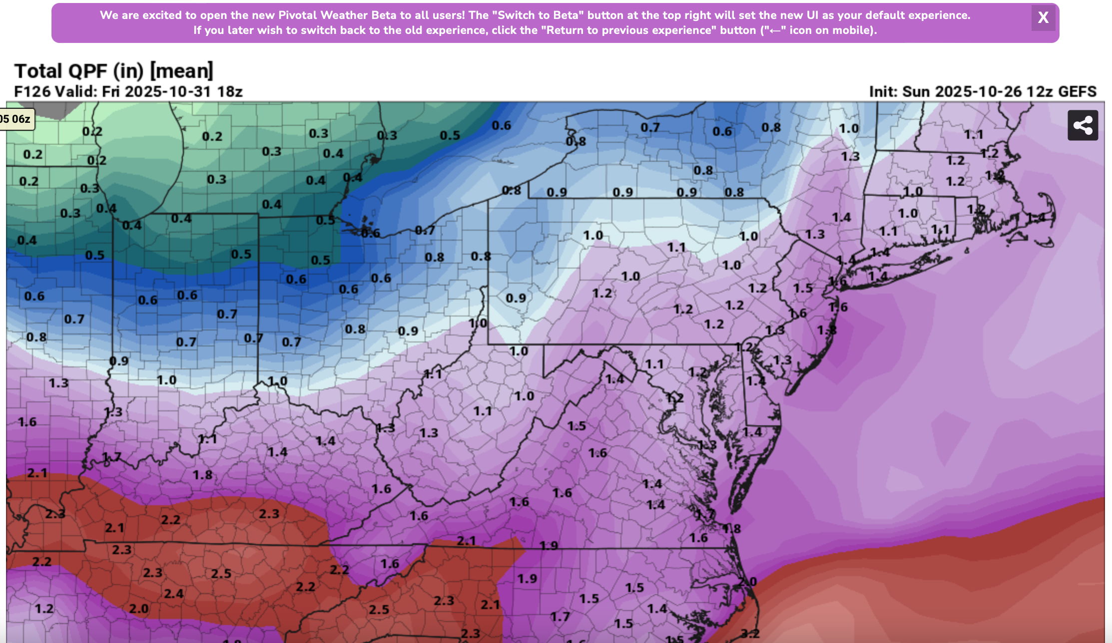
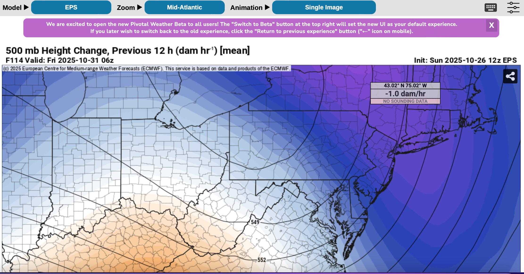
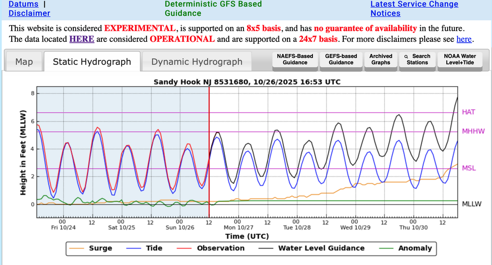
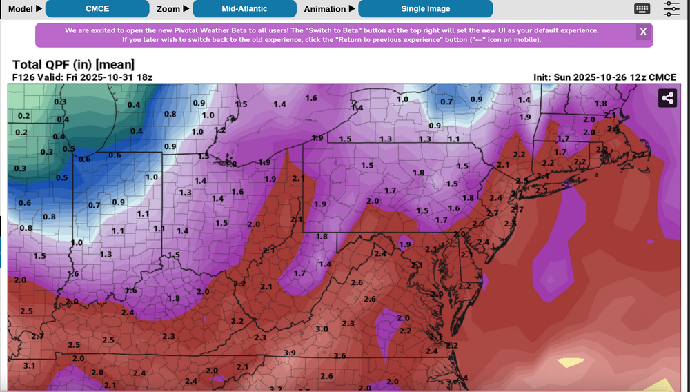
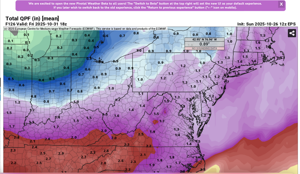
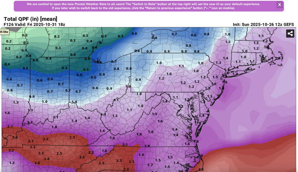
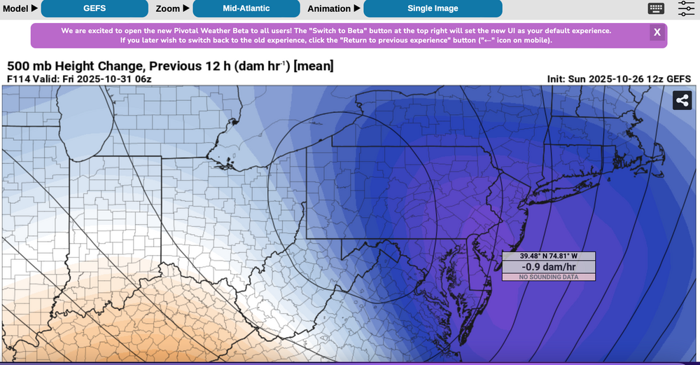
 Please follow any NWS Watches, warnings, statements that may arise from this coming minor or moderate event. This is a D4-5 advance heads-up thread for those who have a need to be advised. Modeling has plenty of spread in solutions so that the ensembles are somewhat muted. There is no doubt in my mind that some sort of minor or possibly moderate impact event is coming. Modeling has been wavering for the past 4 days and hopefully uncertainties resolve by mid week. If I had plans as a motorist or via air travel Thursday-early Friday, I'd think about delays and how to minimize adverse impact, then possibly implement changes Tuesday or Wednesday Timing of the 6-10 hour worst case is uncertain. Beneficial rainfall should result in October totals at all NWS OKX-Upton climate sites roughly 3.3-4.3", within about 1/2" of normal. Not everyone will get 1"+ but the attached Sunday afternoon 10/26 WPC guidance is a best estimate for D4-5. Rainfall still could end up less than indicated. A graphic of average return interval (ARI) for various event amounts, at NYC, is attached-not alarming. This could still end up a routine event although I think wind can add impact. Rainfall intensity during one of the rush hours combined with potential for a period of east-southeast wind gusts 45-55 mph on the remaining wet fully leaved trees may result in a scattering of broken limb caused power outages, similar to the 10/12-13 event. Lunar cycle argues for maximum worst case coastal flooding in the minor category. Modeling from P-Surge is attached. It might be too robust (follow NWS), suggesting a worst cause 3 ft surge along parts of the coasts during the Thursday afternoon-evening high tide cycle (using Sandy Hook as example). Lowered pressure this time compared to 10/12-13 contributes to the surge. Please be aware ensembles are not showing much more than 50-55knot se inflow here, limiting potential for excessive rainfall and surge. There is a slightest chance for isolated severe however CAPE seems to be very limited, despite the favorable strong shear and diffluent upper level flow. A 100-150M 12 hour 500 MB Height Fall Center circles northeastward from the southeast central USA into PA/NJ early Friday. That helps drive the relatively short duration heavy rain event. Presuming the upper Low continues to evolve northward through PA into NYS the eastern Great Lakes there should be a progressive rapid improvement sometime Friday morning. Westerly winds may gust 25-35 MPH at times during Halloween evening but hopefully without any showers in the area. Ensemble rainfall from several modeling centers has been attached as something to look back upon Saturday 11/1 when all the totals are in. The 500MB ensembles attached also show the 12 hr HFC. Fairly modest in comparison to some of the operational cycles we've been seeing the past several days. If the 5h ensemble pattern prevails or is further west, then we've tracked a routine event. The thread current headline will eventually update if moderate impact potential decreases. For now this hopefully adequately summarizes what is on the table for rain/wind/coastal concerns. Let's see if its worth tracking. 620P/26
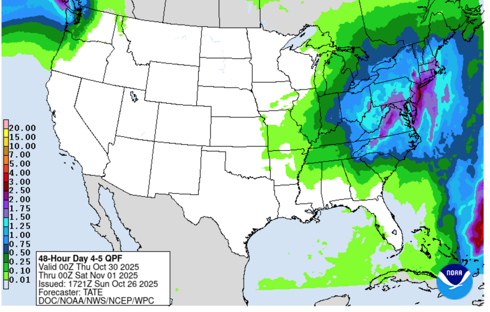


-
On Friday I listened to a briefing from the chief meteorologist for the Jamaican weather service and, at that time, the *center* of the NHC cone kept Melissa skirting around the western side of Jamaica. And in his briefing he stated "Right now, Jamaica should be protected as Melissa goes around the island". Like no sir, that's THE CENTER of the storm. Impacts are wayyyy outside the cone. I audibly gasped at his statement. I really really hope they are prepared for this.
-
Jamaica's weather service not anywhere close to positioned to handle this kind of event, site often not loading or slowly loading for me. Eyes of the world are trying to watch right now... amazing event about to unfold here.
-
I am thinking the same for here. There has actually already been frost in my neighborhood in the low spots but not in my yard (I am on a hill top).
-

Spooky Season (October Disco Thread)
Typhoon Tip replied to Prismshine Productions's topic in New England
ping pong balls of objective reality off the brick of denialism -

The return of the elusive Nor'easter. Drought buster or bust?
IronTy replied to dailylurker's topic in Mid Atlantic
I can't even imagine how intense this board is gonna get when the day finally comes... -
18 was nice. Shut down school for a week. Nice cold was attach to it also .
-
Honestly a lot of our best snows the past 20 years have been before or near Christmas storms. 2009 big storm area wide 10-16" 2010 Christmas snow are wide 6-12" 2017 overrunning snow area wide 4-8" 2018 big storm area wide 10-16" And by area wide I mean WNC
-
Where I am I think it’s pretty likely. Dews are in the upper 20s and wind should be about calm.
-
That is one of the more impressive eyes I can remember. Would not want to be anywhere near Jamaica right now. .
-

Spooky Season (October Disco Thread)
dendrite replied to Prismshine Productions's topic in New England
Chilly evening. 43° and breezy -

Spooky Season (October Disco Thread)
Chrisrotary12 replied to Prismshine Productions's topic in New England
November 3rd storm might have been interesting if it wasn't getting a swift kick in the rear. -
Would not be surprised to see my first frost tomorrow morning
-

Spooky Season (October Disco Thread)
CoastalWx replied to Prismshine Productions's topic in New England
There is no miracle. -
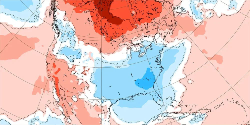
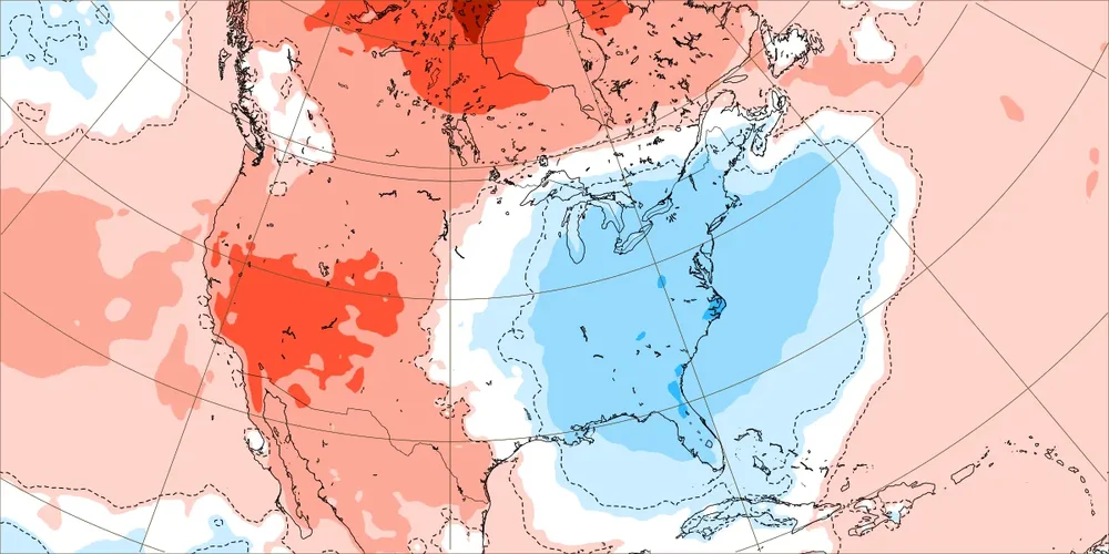
Today’s Euro Weeklies out 6 weeks for E US: - Coldest 1st 2 weeks of any run (see below) for that period thanks to a combo of an impressive +PNA and impressive ascending -NAO, which should it verify closely would be coldest for E US overall since the similarly chilly 2012 for Oct 27-Nov 9. For those curious, that period in 2012 actually had a mean near opposite weak -PNA as well as a similarly strong -NAO and weak -AO. Edit: it had a +EPO like we have now. It had for MJO moderate 2, mod 3, and ended with weak 4. - No long period of mild in sight with weeks 3, 5, and 6 NN and week 4 only barely AN Week 1 (Oct 27-Nov 2): Week 2 (Nov 3-9):
-
.thumb.png.4150b06c63a21f61052e47a612bf1818.png)
Spooky Season (October Disco Thread)
HIPPYVALLEY replied to Prismshine Productions's topic in New England
We both know that’s not happening. -

Spooky Season (October Disco Thread)
Torch Tiger replied to Prismshine Productions's topic in New England
Pray it misses Jamaica way way west. :/ - Today
-

Spooky Season (October Disco Thread)
ineedsnow replied to Prismshine Productions's topic in New England
Icon moved west a bit.. Melissa looks to be heading wsw again looking at satellite.. we hope for a miracle -
Spooky Season (October Disco Thread)
CoastalWx replied to Prismshine Productions's topic in New England
Maybe next year. We just don’t know. -
NOAA satellite loop hasn’t updated since early this morning. Nice day here, though…probably managed about 50/50 sun/clouds.
-
Made it to 64 before more clouds came in around 2:/2:30 and had been mostly cloudy since.