All Activity
- Past hour
-
No Saturday.
-

Winter 2025-26 Medium/Long Range Discussion
Baum replied to michsnowfreak's topic in Lakes/Ohio Valley
Counter: https://x.com/weatherwilly/status/2018005302247931955?s=61 -
2nd attempt may do It at the end of the run.
-

Central PA Winter 25/26 Discussion and Obs
Jns2183 replied to MAG5035's topic in Upstate New York/Pennsylvania
It by some good luck we can pull out 4"+ combined this week, those tundra winds combined with artic cold will give the deep winter the proper send off it deserves as temperature moderate slowly. Sent from my SM-S731U using Tapatalk -

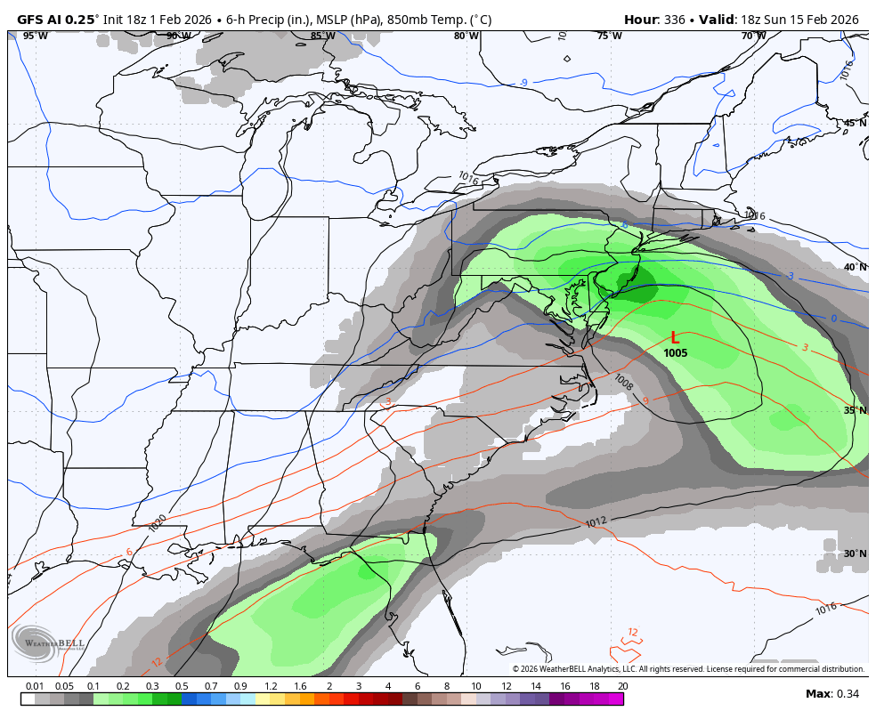
February 2026 Medium/ Long Range Discussion: Buckle Up!
Blizzard of 93 replied to Weather Will's topic in Mid Atlantic
Surface is intriguing as well…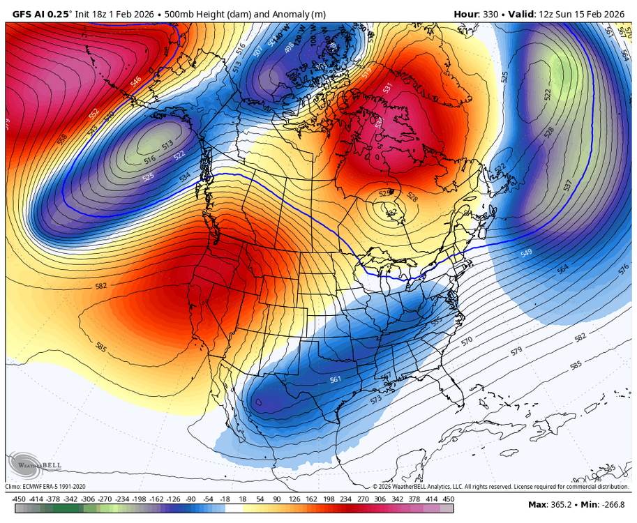
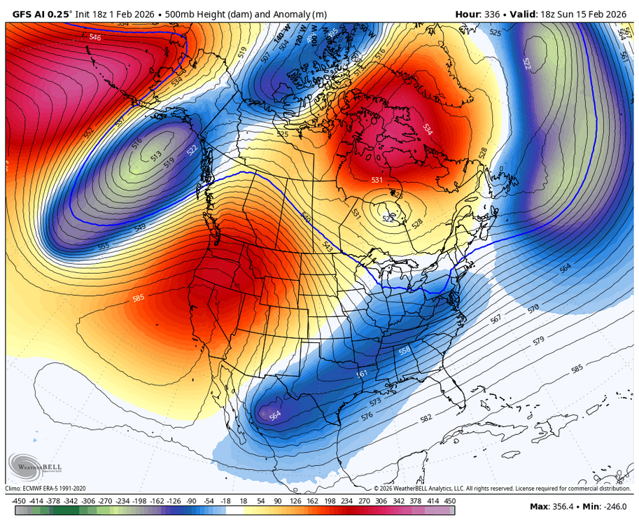


-
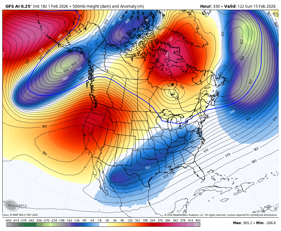
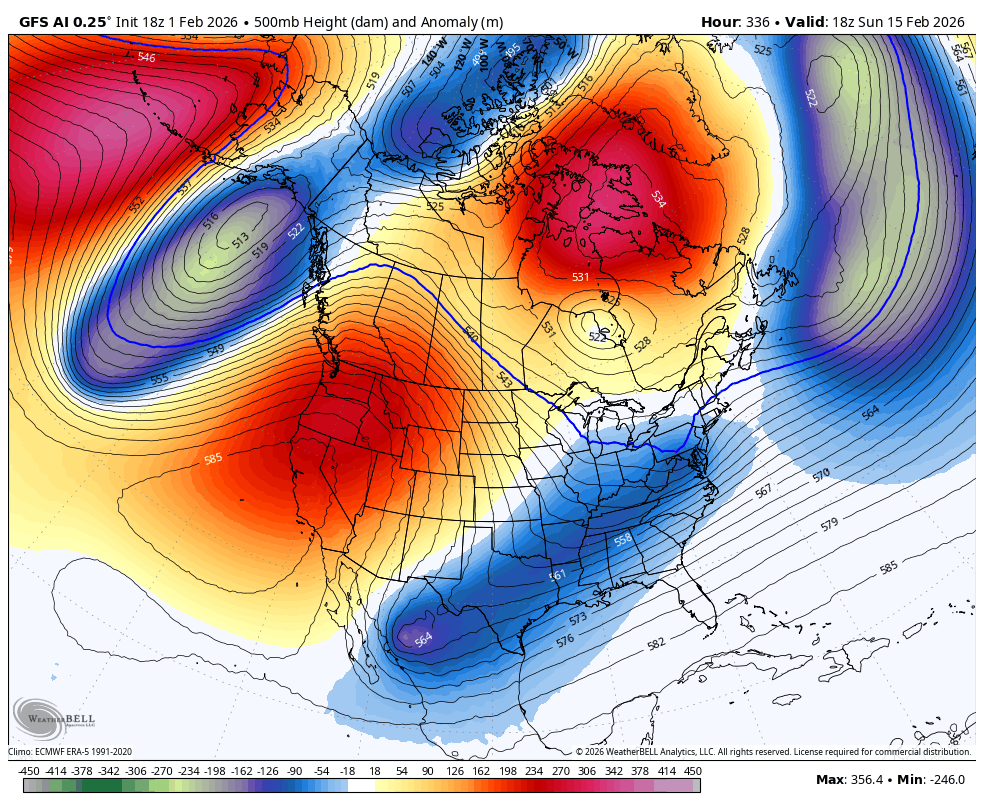
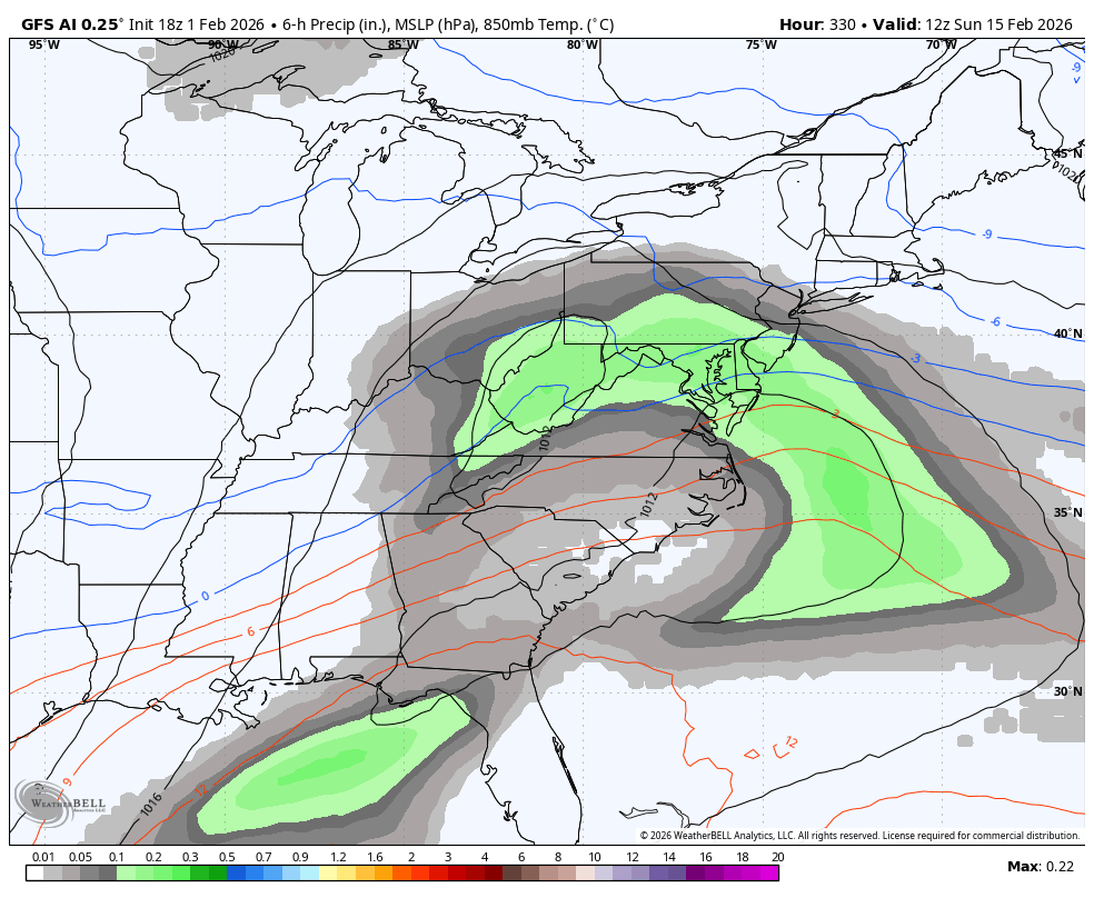
February 2026 Medium/ Long Range Discussion: Buckle Up!
Blizzard of 93 replied to Weather Will's topic in Mid Atlantic
The 18z GFS Ai has an interesting look out in fantasy land on PD weekend.
-

The Jan 31 Potential: Stormtracker Failure or 'Tracker Trouncing
IronTy replied to stormtracker's topic in Mid Atlantic
Turns out my sister is a weenie too I guess. She ended up with 6"....in Charlotte, SC.
-
Is that for mid month? Of course, a big MAYBE.. I know ...
-

WxUSAF's weak ass frontal passage thing.
Ralph Wiggum replied to dailylurker's topic in Mid Atlantic
I will accept my 12 flake refresher! https://youtu.be/w2kf6xcuBhg?si=E3EtSdwHRTEuMSYu -
We need one of these CA bowling balls to come across the conus. Gfs tries that but it’s a little mild in SNE except maybe far interior.
-
I remember getting 24" of snow in Ontario in early April 1975 followed by several days of clear, cold weather with a similar sun angle to what you have there now ... we had a daily freeze-thaw cycle and the snow drifts froze solid, couldn't move them at all. That snow never melted, it just sublimated over ten days until most of it was gone. It was bone dry all through that period. Maybe you will see something similar, the snow just gradually disappearing with little or no runoff to the water table.
-
not seeing it anywhere -in the short term - was just "saying" BUT chances are by mid - month we will touch 40 again....
-
This ain't no weak ass frontal thing. It's gonna overperform.
-

WxUSAF's weak ass frontal passage thing.
Solution Man replied to dailylurker's topic in Mid Atlantic
LFG -
LOL better ski conditions on sand dunes at Cape Hatteras than here at our ski resort, rain and 38F past few days here. Just a note to a few readers, contest deadline was moved back to Feb 2nd 06z (because I thought people would be fully occupied tracking a snowstorm, well anyway) ... so get in there no penalty yet. The January anomalies did some crazy nose dives, DEN was at one point +11.1 and ended up +2.7, ATL went from around +6 to just +0.4 (anomaly), and IAH went all the way down to +0.9 with the late surge of cold air. DCA had an anomaly of -4.2 F. Snow cover matters. ... PHX never got into colder air very much and finished +4.3 F.
-

Is we back? February discussion thread
Damage In Tolland replied to mahk_webstah's topic in New England
Can we peel back roofs ? -
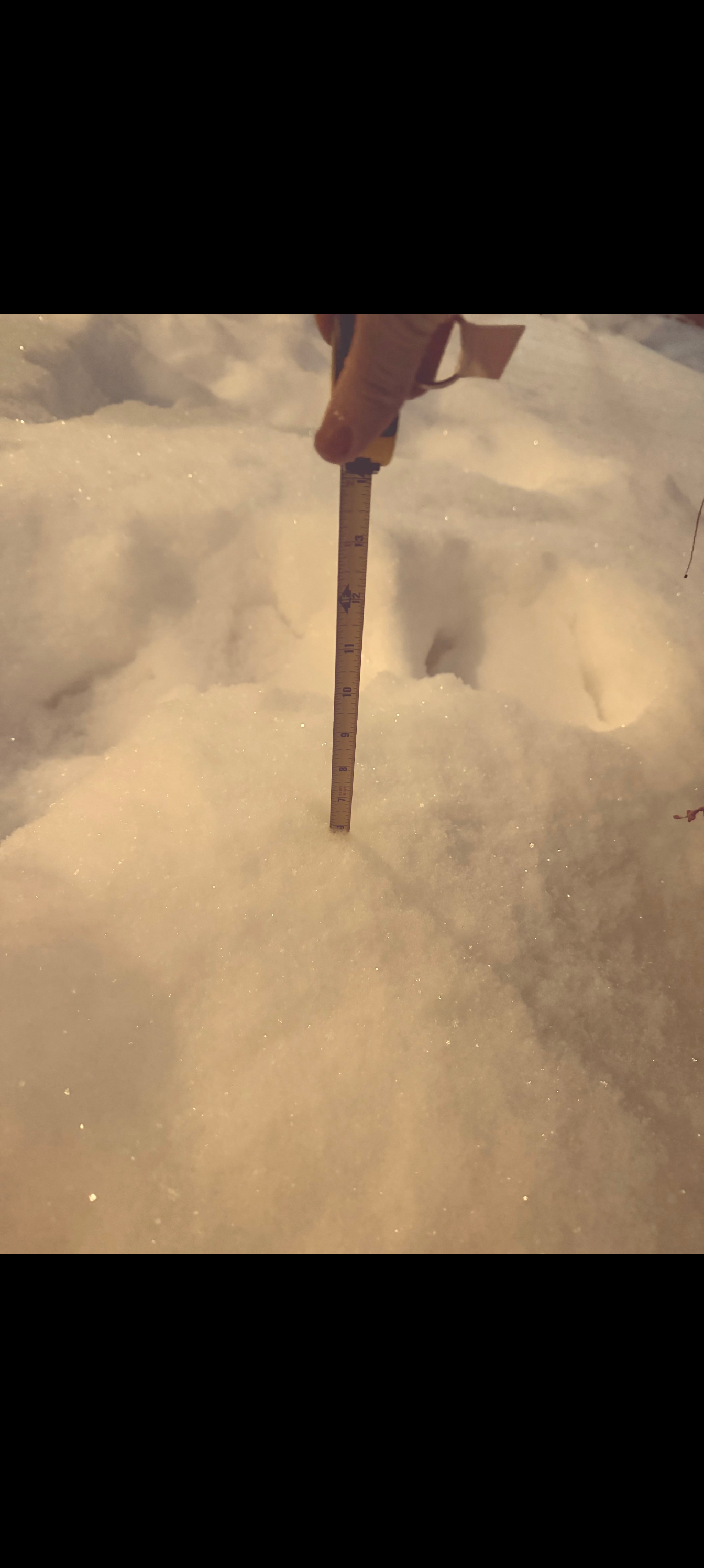
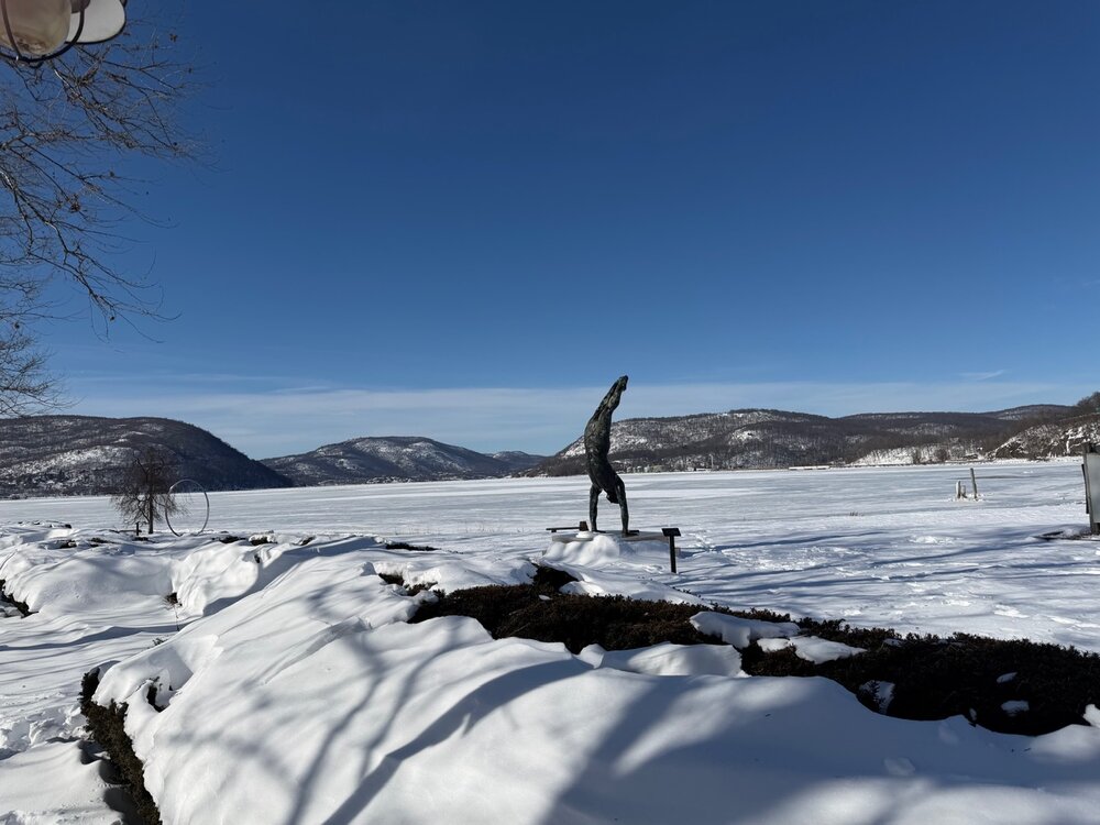
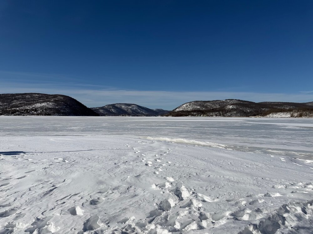
For the record, Peekskill Bay 2/1/26
-
I’m with ya on this. Sure I’ll pay more for heating this season but we’ve been getting off easy for years. I’ll likely tire of it around the same time you will. I’d like to get s9me more snow though. As much as I’m enjoying it I’m also looking forward to that first mild calm sunny day to have a pint on the deck, preferably while there’s still a pack out there.
-
Just shuffling through wx maps and the weeklies. I looks like next weekend could be very cold yet again. Then, we warm-up during the second week of February. That has been well advertised and is no surprise. Then, sometime between d17-24 we could have another strong cool down per the Euro weeklies mean and control. That holds for roughly 2-3 weeks. Again, that really fits the winter pattern. But....changing wave lengths have the potential to create more chaos than normal within modeling. We are entering a time frame where LR modeling gets very undependable, even at the long wave level. But I do think roughly sometime between Feb 17-20 looks like the next resupply of very cold air(after this weekend). The NAO will often not be felt by modeling until just a few days prior to it strengthening. It establishes sometime (if models are correct) between Feb 8-9th. Then, I think it takes about 7-10 days for the eastern NA pattern to respond w/ a suppressed storm track.
-
as it is, that's a damaging CAA wind event
-
There is a February Obs thread. Just waiting for it to be pinned.
-

January 30th- Feb 1st ULL and coastal storm obs
yotaman replied to JoshM's topic in Southeastern States
I have lived here since 1996 and until today, never needed one. -

Central PA Winter 25/26 Discussion and Obs
canderson replied to MAG5035's topic in Upstate New York/Pennsylvania
Strong, big winds likely next weekend. NWS SPC has all of PA already on mod risk of high winds. -
Central PA Winter 25/26 Discussion and Obs
Blizzard of 93 replied to MAG5035's topic in Upstate New York/Pennsylvania
CTP is on board for our 2 chances at light snow this week. KEY MESSAGES... 1) One more night of Advisory-level wind chills tonight 2) Light accumulating snow possible late Tuesday night into Wed (mainly southern PA) 3) Light accumulating snow is possible again Fri-Sat, followed by gusty winds and another shot of Arctic air for next weekend -
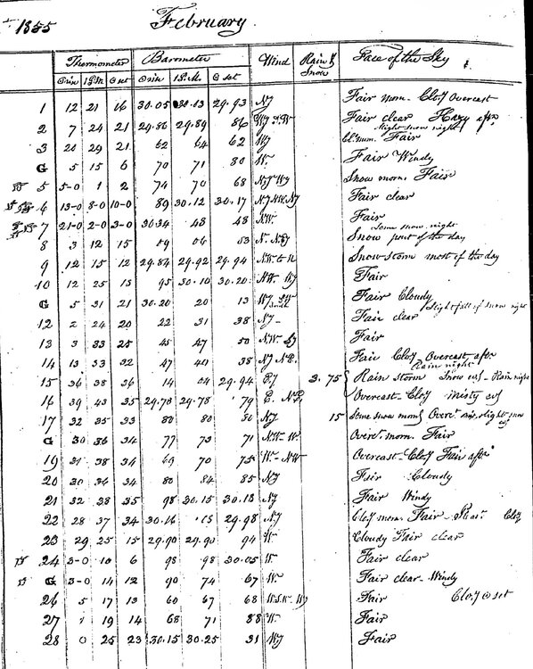
 Feb 1855 for Kennebunk -8 in the afternoon and -21 the next morning. Probably windy. Scrolls for Steve.