All Activity
- Past hour
-
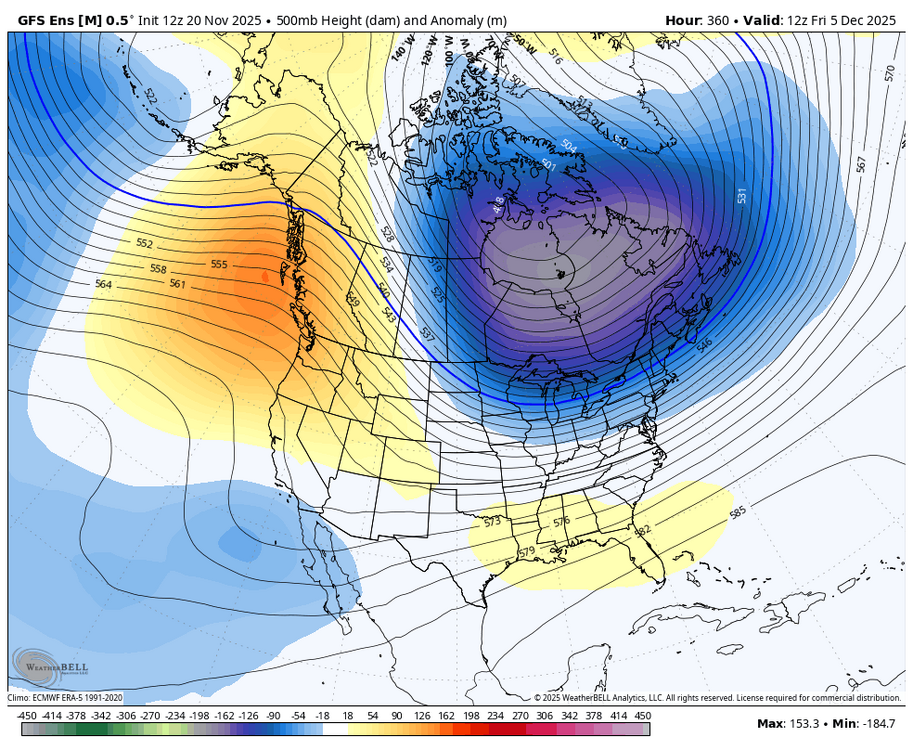
It’s a main feature of the pattern which has been stuck in place for the last 7 years with a brief relaxation during 20-21 and Jan 22. Very hostile Pacific pattern for snow in the I-95 corridor. Good patterns for snow produce classic KU benchmark storms which were in abundance from 2010 to 2018 with the much weaker Pacific Jet. Happened too many times for me to count from 2010 to 2018. Plus I started getting excited about the 20-21 winter during that October with my first successful use for the October MJO indicator for La Ninas. The most recent time was later in December 2021 after the highly amplified December MJO 6-7 stall that month which really pumped the Southeast ridge. But around the holidays the models started showing a legit MJO 8 for January which verified. So that was the last successful MJO 8 passage. We have had many model forecasts for phase 8 since then. But none have worked out due to interference from the WPAC warm pool. So I would like to see all the VP anomaly charts showing weakening forcing within week 1 near the Maritime Continent for the forecast to be believable.
-

Central PA Fall Discussions and Obs
canderson replied to ChescoWx's topic in Upstate New York/Pennsylvania
troegs meet up party? -
18z GFS/GEFS shows a legitimate fail mode for us, and one that I'm always concerned about happening. The trough dumps out west, flexes the southeast ridge, and we just torch while the central and western US score. Hope this is just a fluke.
-
29 now. 50 earlier
-
-

Central PA Fall Discussions and Obs
Jns2183 replied to ChescoWx's topic in Upstate New York/Pennsylvania
All I ask for Christmas is a six pack of mad elf, a 2am Namming as flakes fly outside, and a predawn elf enhanced walk in a snow globe Sent from my SM-G970U1 using Tapatalk -
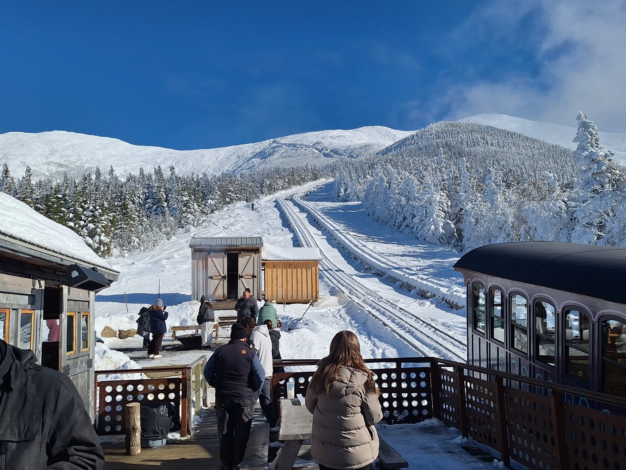
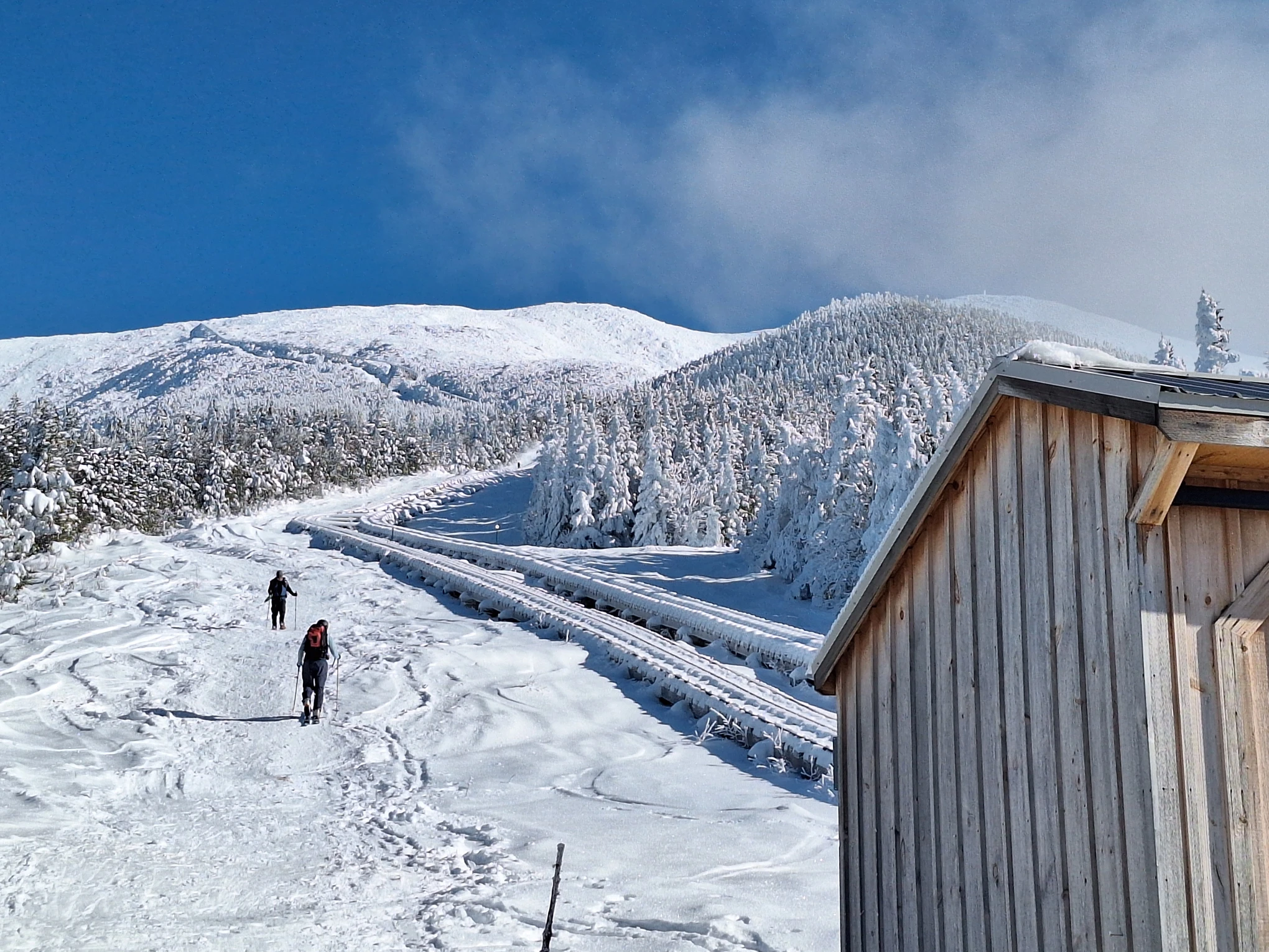
Spectacular day for a trip up the Cog Railway to 4000 feet.


-

November 2025 general discussions and probable topic derailings ...
kdxken replied to Typhoon Tip's topic in New England
Is that Keanu Reeves? -
Central PA Fall Discussions and Obs
Jns2183 replied to ChescoWx's topic in Upstate New York/Pennsylvania
The December to Remember vibes keep getting better! Sent from my SM-G970U1 using Tapatalk -

Central PA Fall Discussions and Obs
Blizzard of 93 replied to ChescoWx's topic in Upstate New York/Pennsylvania
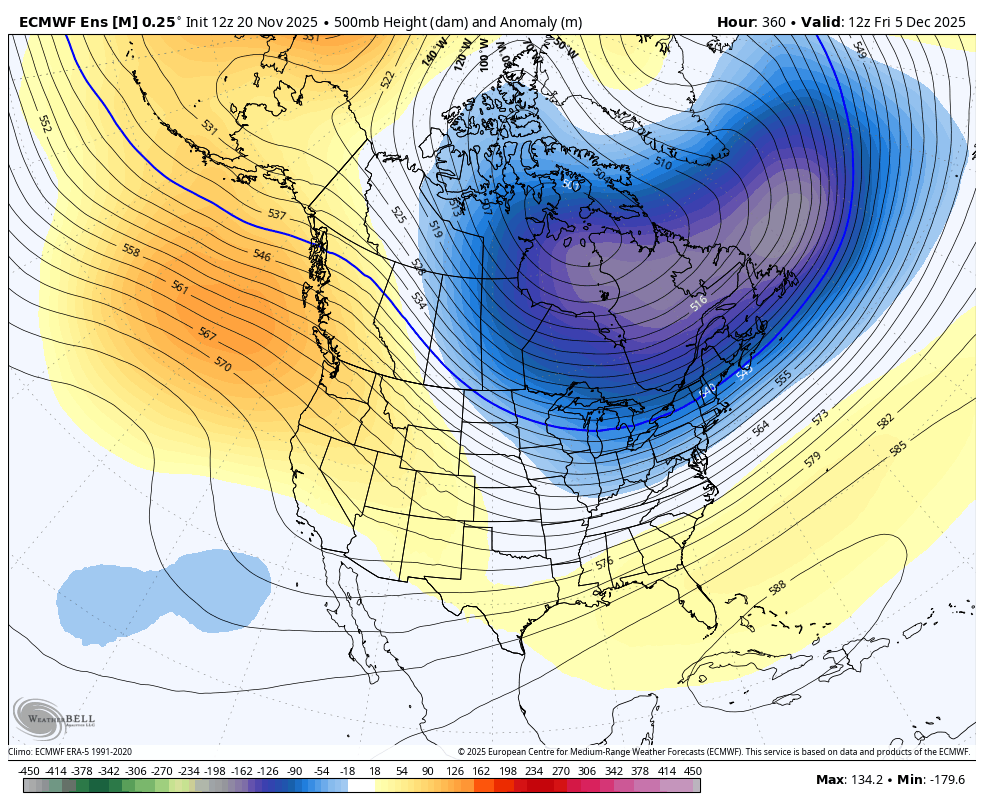
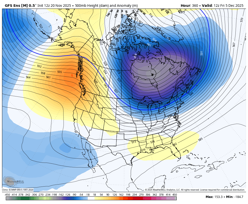
The pattern progression was evident on the 12z EPS & GEFS today. By December 5th, a favorable pattern with winter storm chances should emerge if the advertised looks on the ensembles & weeklies come to fruition.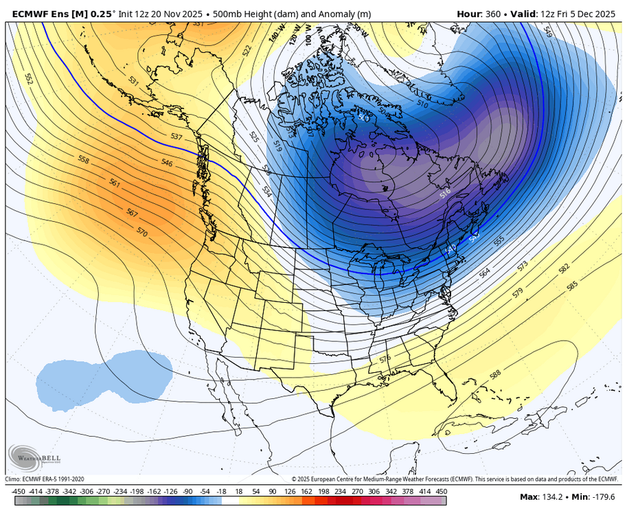
-
Central PA Fall Discussions and Obs
Blizzard of 93 replied to ChescoWx's topic in Upstate New York/Pennsylvania
The models backed off of that next weekend storm idea for now. Let’s see if it shows back up or not. -

November 2025 general discussions and probable topic derailings ...
Torch Tiger replied to Typhoon Tip's topic in New England
Yeah median=middle -

November 2025 general discussions and probable topic derailings ...
WinterWolf replied to Typhoon Tip's topic in New England
Isn’t the median the middle, and the mean is the average? -
I guess there could be some sleet at the onset (GFS) ahead of the rain on the Tuesday before Thanksgiving in the northern suburbs. Otherwise not much wintry to track for the moment. Hope it changes for the better soon.
-
Quite a few but the last couple el ninos sucked even worse TBH
-
What about the past 20
-
 Beerdian vs beer?
 -
Agreed. Here they changed fast and nearly all the trees lost their leaves at the same time. Made cleaning up nice for a change instead of doing it weekly for like 6 weeks. I only did one big cleanup last week, and tomorrow ill do a mow/mulch of what's left.
-

November 2025 general discussions and probable topic derailings ...
dendrite replied to Typhoon Tip's topic in New England
Mode? -
 Chinook changed their profile photo
 -
Good news is the pacific doesn’t look as F’d as it did a few days ago. PNA Pretty much stays neutral now. That’s always the first place I look. As for the SER, as long as we don’t get that big western trough it can be beat back. A La Niña paired with a negative PNA is a death sentence for the southeast winter lovers
-

E PA/NJ/DE Autumn 2025 Obs/Discussion
simbasad2 replied to PhiEaglesfan712's topic in Philadelphia Region
There was actually some pretty decent ensemble support earlier this week of an amplified shortwave to emerge behind the Thanksgiving system around the weekend of 11/29-30. Unfortunately this looks unlikely now -

Fall 2025 Medium/Long Range Discussion
ChiTownSnow replied to Chicago Storm's topic in Lakes/Ohio Valley
@Chicago Storm we need your mid range pattern analysis posts.. seems pattern change is immenet come end of month. - Today
-

2025-2026 ENSO
brooklynwx99 replied to 40/70 Benchmark's topic in Weather Forecasting and Discussion
honest question, is it possible for models in the 1-2 week range to show a pattern that you will actually get excited about? -
34 here, low was 30.2, second freeze of the season. Peppers look unhappy but otherwise alive. They didn’t flinch at the first freeze (31.6) on 11/7.
-

December 2025 Short/Medium Range Forecast Thread
jaxjagman replied to John1122's topic in Tennessee Valley
Cool,he finally got this running again.thumb.png.8754ab3f849d107be4ed22622bf61488.png)


.png.363184d55bca212eb42bb968f3f78e60.png)