All Activity
- Past hour
-
Was just about to post this. Seems more likely we don't torch, but rather have only a brief relaxing of the cold.
-
17. Was expecting colder
-

E PA/NJ/DE Winter 2025-26 Obs/Discussion
PhiEaglesfan712 replied to LVblizzard's topic in Philadelphia Region
1995-1996 -> That one was a wall-to-wall great winter. 2000-2001 -> Okay winter overall, but left a very sour taste with the huge snow bust in March. 2005-2006 -> Very mild January, but a return to winter in February, highlighted by the snowstorm on the 11th-12th. March is mild. 2010-2011 -> Very cold and snowy January, turns milder in February, although a moderate snowfall happens around President's Day. No more snow after that, but we do get one last hurrah of well below average temperatures in late March. 2020-2021 -> January has no snow and above average temperatures until the last day of the month. February is cold and snowy. March is mild. -
Anyone know why two different snowfall amounts are showing up for NYC? CLIMATE REPORT NATIONAL WEATHER SERVICE NEW YORK, NY 159 AM EST MON DEC 15 2025 ................................... ...THE CENTRAL PARK NY CLIMATE SUMMARY FOR DECEMBER 14 2025... CLIMATE NORMAL PERIOD 1991 TO 2020 CLIMATE RECORD PERIOD 1869 TO 2025 WEATHER ITEM OBSERVED TIME RECORD YEAR NORMAL DEPARTURE LAST VALUE (LST) VALUE VALUE FROM YEAR NORMAL ................................................................... TEMPERATURE (F) YESTERDAY MAXIMUM 33 630 AM 67 1881 45 -12 34 2015 MINIMUM 19 1159 PM 12 1976 34 -15 26 AVERAGE 26 40 -14 30 PRECIPITATION (IN) YESTERDAY 0.51 2.22 1897 0.15 0.36 0.00 MONTH TO DATE 1.41 2.07 -0.66 1.39 SINCE DEC 1 1.41 2.07 -0.66 1.39 SINCE JAN 1 37.60 47.21 -9.61 43.23 SNOWFALL (IN) YESTERDAY 2.9 5.8 2003 0.2 2.7 0.0 MONTH TO DATE 2.9 1.7 1.2 T SINCE DEC 1 2.9 1.7 1.2 T SINCE JUL 1 2.9 2.3 0.6 T SNOW DEPTH 1 Climatological Data for NY CITY CENTRAL PARK, NY - December 2025 Click column heading to sort ascending, click again to sort descending. Sum 552 379 - - 442 0 1.41 4.4 2025-12-01 43 34 38.5 -4.7 26 0 0.00 0.0 0 2025-12-02 40 34 37.0 -5.9 28 0 0.78 0.0 0 2025-12-03 41 31 36.0 -6.6 29 0 0.00 0.0 0 2025-12-04 41 24 32.5 -9.8 32 0 0.00 0.0 0 2025-12-05 32 20 26.0 -16.0 39 0 0.00 0.0 0 2025-12-06 42 30 36.0 -5.7 29 0 0.02 T 0 2025-12-07 43 34 38.5 -2.9 26 0 0.00 0.0 0 2025-12-08 38 22 30.0 -11.1 35 0 0.00 0.0 0 2025-12-09 35 19 27.0 -13.9 38 0 0.00 0.0 0 2025-12-10 47 32 39.5 -1.1 25 0 0.07 0.0 0 2025-12-11 41 28 34.5 -5.8 30 0 0.00 0.0 0 2025-12-12 35 25 30.0 -10.0 35 0 0.00 0.0 0 2025-12-13 41 27 34.0 -5.7 31 0 0.03 T 0 2025-12-14 33 19 26.0 -13.5 39 0 0.51 4.4 3 2025-12-15 M M M M M M M M M 2025-12-16 M M M M M M M M M 2025-12-17 M M M M M M M M M 2025-12-18 M M M M M M M M M 2025-12-19 M M M M M M M M M 2025-12-20 M M M M M M M M M 2025-12-21 M M M M M M M M M 2025-12-22 M M M M M M M M M 2025-12-23 M M M M M M M M M 2025-12-24 M M M M M M M M M 2025-12-25 M M M M M M M M M 2025-12-26 M M M M M M M M M 2025-12-27 M M M M M M M M M 2025-12-28 M M M M M M M M M 2025-12-29 M M M M M M M M M 2025-12-30 M M M M M M M M M 2025-12-31 M M M M M M M M M
-
You’ve already had a good winter!
-
NYC area final totals from yesterday’s storm
-
“Average” line cuts through our region on all 4 clusters
-
Currently at 7 degrees, still a little more time to go a little lower.
-
Only dropped a couple of degrees overnight but it’s 10 here now. Legit cold for mid December.
-

Central PA Winter 25/26 Discussion and Obs
Voyager replied to MAG5035's topic in Upstate New York/Pennsylvania
I'd either scroll on by or just answer the question. It wouldn't bother me. Like itstrainingtime, I don't do most social media. Facebook, YouTube, and here is all I do. I still don't see anything wrong with what Canderson posted. I really can't figure out your beef with him. Everyone else, me included, like and respect the guy. -

Winter 2025-26 Medium/Long Range Discussion
Baum replied to michsnowfreak's topic in Lakes/Ohio Valley
I’m ready. -
Must be something about part of the PV rotating through and out.
-

December 14th - Snow showers or Plowable snow?
The 4 Seasons replied to Sey-Mour Snow's topic in New England
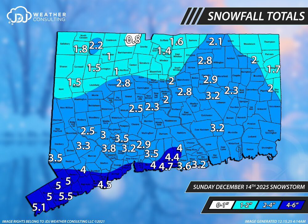
This is a preliminary first pass snowfall totals for CT. Once i get the totals from cocorahs/coop today ill update the map and be doing a full SNE one and Tri-State. I tried to include all the reports from here as well as filter out all the old reports. If anyone has any corrections, concerns or violent reactions let me know and ill take a look into it. There were a lot of reports from the same town or very close to each other so i had to leave some out. Thanks to everyone who sent me a report. I might change the ranges from 0-1/1-2/2-4/4-6 to 0-1/1-3/3-6 for the final map to make things a little easier and because there are a lot of 2"+ reports mixed in around the 1-2" reports. This is also the second 3"+ event of the season so it will make it into the WS Archive with radar/sfc/h5/snowfall maps when they come available. BDR-4.5, BDL-1.4, ORH-1.6, PVD-1.6, BOS-1.3 The forecast overall was pretty good albeit a little conservative. I'll give it a B+. We did highlight the possibility of 4"+ on the extreme S coast so that worked out well. All of the southern 4 counties verified advisory level snow with generally 3-6" and 1-3" mainly for the northern 4 counties. Lowest report was E. Hartland at 0.8" and the highest 5.5" in Norwalk. @Sey-Mour Snow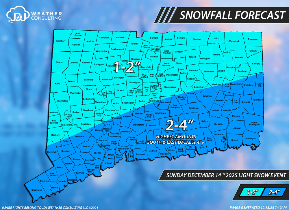
-

Moderate snowfall 12/14/2025 WWA up for most of the area
snowman19 replied to WeatherGeek2025's topic in New York City Metro
Yep. I was wrong, will gladly admit it. I never thought the trough would end up going neutral tilt. Congrats on the snow everyone - Today
-

2025-2026 Fall/Winter Mountain Thread
Buckethead replied to Buckethead's topic in Southeastern States
Even Mt. Mitchell is up to 20 this morning. Sent from my SM-S908U using Tapatalk -
2025-2026 Fall/Winter Mountain Thread
Buckethead replied to Buckethead's topic in Southeastern States
Nope, calm conditions. Sent from my SM-S908U using Tapatalk -

Central PA Winter 25/26 Discussion and Obs
pawatch replied to MAG5035's topic in Upstate New York/Pennsylvania
12 degrees this morning. Not as low as forecasters was calling for. Sounds like a cold blustery day….bundle up -
Mmmmm that is interesting. You still windy up there?
-
2025-2026 Fall/Winter Mountain Thread
Buckethead replied to Buckethead's topic in Southeastern States
I'm starting out at 23. I wasn't expecting that! Sent from my Pixel 10 Pro using Tapatalk -
Current temp is 6 degrees.
-
16.7, I think we will have a good winter.
-
15.1 right now still dropping. About as cold as it can get here without snowpack. If you added snow cover to this airmass here you’d see spots in central NC approaching 0. We’re a whopping 39 degrees colder than this time yesterday
-
13.3 at 4:10. My lowest this year was 10.6 on 1/22. .
-
Down to 16.9.


