All Activity
- Past hour
-
That’s just mean
-
You can be sure that if this was/turns out to be a rainer, it will verify.
-
I'm not so sure? There is something about the look of the large-scale pattern trends, medium range guidance suggestions, and some historical time frames that peaks my interest a bit more than I would normally give to 10-day Outlook. Over the years I've always liked two February periods; Feb 3-6, and Feb 12-16? If I were a betting man, I might wager on this upcoming period ( Feb 13-15) breaking our way... In no way a hard and fast forecast and a complete failure is certainly on the table, but I'd spin the storm roulette wheel on that time period. Add to the mix that I have 2 incredibly important family matters to attend on the 14th could seal the deal... Lol
-
-

February 2026 Medium/ Long Range Discussion: Buckle Up!
GreyHat replied to Weather Will's topic in Mid Atlantic
Yep, changes will happen. -

February 2026 Medium/ Long Range Discussion: Buckle Up!
psuhoffman replied to Weather Will's topic in Mid Atlantic
I know, I've said this numerous times. I actually find your performace to be entertaining...but I know some do not. The bigger problem is there are now 100 others trying to do what you do...and it's hard to moderate them when one of the board OGs is doing it. -

2025-2026 Fall/Winter Mountain Thread
Maggie Valley Steve replied to Buckethead's topic in Southeastern States
It's warmed up to 53 this afternoon and the snow melt at the Valley floor is almost done. Looks like the surface low has developed in NE Georgia, so a couple of low based thunderstorms are likely as Buckethead just posted. It looks like a dusting to an inch this evening into early Thursday morning for most of us in the Mountains with higher totals in the Northern Mountains. -

Winter 2025-26 Medium/Long Range Discussion
McHenrySnow replied to michsnowfreak's topic in Lakes/Ohio Valley
No, I agree with your overall sentiment, I'm just one of the few who wants it to snow whenever it can no matter how long it lasts. Obviously, I prefer 6" or more that stays on the ground for a few weeks, at least, but desperate times......we'll probably overperform on the Thursday night/Friday morning clipper solely because it will all melt a few hours later. That has happened twice to me this winter. Melting snow is truly one of the most depressing things for me. Everyone goes on about SAD in the winter meanwhile I have SAD from April through November. -
February 2026 Medium/ Long Range Discussion: Buckle Up!
GreyHat replied to Weather Will's topic in Mid Atlantic
Couple cutters then this one, for delmarva long range forecast has been advertising 40s through 18th with rain 12-17. -
February 2026 Medium/ Long Range Discussion: Buckle Up!
psuhoffman replied to Weather Will's topic in Mid Atlantic
The thermal profile of the storm is fine...the track is just a slight bit inside what we want...adjust track of the secondary 50 miles SE and its a huge snowstorm 95 NW. I could waste my time digging into exactly why the track is slightly inside perfect but I am not going to because we are going to see way more error adjustment than 50 miles at this range...the whole thing is going to change...timing will adjust some, the thermals could get colder and then this track could work...the track could shift 100 miles either way...and those would be considered extremely minor errors and a huge win if thats all this adjusts from 200 hours out! -

2025-2026 Fall/Winter Mountain Thread
Buckethead replied to Buckethead's topic in Southeastern States
Sitting in a decent thunderstorm just north of Burnsville currently. Sent from my Pixel 10 Pro using Tapatalk -
 Very little wind up here. Glad we here.
-
I'm so confused?? Last time I checked in we were getting no meaningful snow or precipitation until April? Isn't that what those 384 HR OP runs were showing???
-
 31 but feels colder.
 -
It's one for the books down here. I'm still at basically 100% coverage. Many side roads are still a packed glacier. Took my dog up smith mtn fire road yesterday and someone had a snowmobile up there within the last couple days lol. 100% coverage for 12 consecutive days has to be a record or close to a record in these parts. My climo kinda sucks (12"+/-) but I'm at 13"+ with 4 legitimate accum events. This winter gets a minimum grade of A- from me. If PD3 pans out or any other decent accum event it would be an A+ based on how I look at this stuff.
-

Central PA Winter 25/26 Discussion and Obs
canderson replied to MAG5035's topic in Upstate New York/Pennsylvania
Yup definitely do - I’ll hit them up. There’s an excellent hardware store down near Etters that is amazing and I tend to forget they sell everything . -
Feb Nina -PNA is serviceable here. Averages around 50% of normal (10”). Would say that weak-warm +ENSO Feb performs the best here, however. Such as in 2020, 2019, 2015, 2007.
-

E PA/NJ/DE Winter 2025-26 Obs/Discussion
RedSky replied to LVblizzard's topic in Philadelphia Region
Seasons pattern ftw -
^ Based on that, southern Wake County (and a few other bordering counties) is experiencing the longest 6+" snow drought of anywhere in the state save that sliver of brown in the SE corner of the state.
-
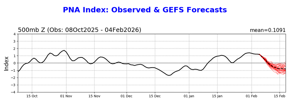
The biggest challenge for a big NC snowstorm on Val. Day is going to be the progged -PNA by the model consensus (opposite of what the last storm had) as only 10% of the 6”+ storms since 1950 that occurred at RDU and/or GSO were when the PNA was sub -0.5: Sub -0.5 PNA for 6”+ snowstorms RDU/GSO -0.8 1/22-24/1954 -0.8 3/2-3/1960 -1.1 2/12-13/2014 -0.7 1/6-7/2017 In contrast, there have been 4 times as many (16) that occurred with a PNA of +0.5+. (This analysis has nothing to do with major icestorms, which I’m assuming on average have had better results than big snows when there’s a -PNA.)
-
Nope
-
12z suite gonna make us track a system from 10 days out?! Just 40 more runs to go! LOL
-

Winter 2025-26 Medium/Long Range Discussion
Malacka11 replied to michsnowfreak's topic in Lakes/Ohio Valley
Right. And I'm sure Joe wouldn't be shocked if we reel a storm in either after all in a week or two, since he never really recanted his prior optimism in favor of remaining aloof. My point is that the second issues like sun angle and shit become a problem, I'd rather just save our year-to-year pretend climo snowfall luck for next season. If we miraculously manage to mitigate whatever warmup is locked in and we reel in a monster 10-14 days from now, great. Too bad we couldn't get it in December. Normally I'd be here excited for the DABs we've got coming but again, it's completely futile because we're completely resetting next week it seems. I understand this is a personal banter take but -
 Amazing what a little wind can do to change the tenor of the outdoor feel... Almost the same temp as yesterday right now, but with a steady 12 mph wind, gusting to 25 mph... The walk around the neighborhood was nowhere near as comfortable as it was yesterday!
 -
Another pleasant sunny day. High 29°


