All Activity
- Past hour
-
If by “horrible” you mean cool spring in the E US, good! Bring it on as I love it way down here! Actually cool April here means highs mainly 65-75 and lows 40-52 along with nice low dewpoints for great outdoor wx!
-
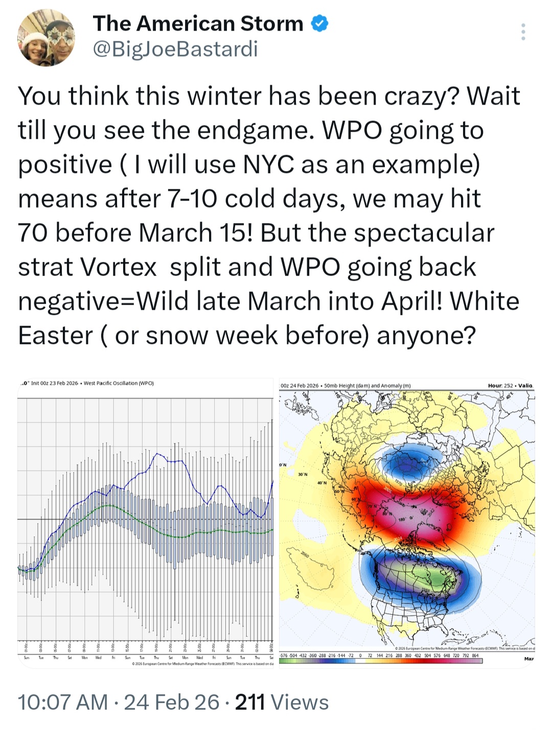
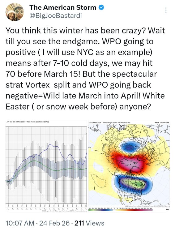
Ehhh around 3/15 more likely
-
Given the cold shelf waters, it will be a battle this spring to get any nice weather outside of a random day here and there
-
Great post, thank you. We’ll keep an eye on how the nino develops and how much it strengthens. I don’t know how we will end up categorizing the type, but I don’t think we go higher than moderate based on RONI.
-

Central PA Winter 25/26 Discussion and Obs
anotherman replied to MAG5035's topic in Upstate New York/Pennsylvania
Yeah, 2027 looks unlikely…. -
Next bit of interesting weather is some training of heavy rain cells Thurs/Friday that could lead to flash flooding concerns over a narrow stripe

-
-

"Don’t do it" 2026 Blizzard obs, updates and pictures.
OceanStWx replied to Ginx snewx's topic in New England
In a typical developing (i.e. not peak intensity) storm your frontogenesis is going to be sloped towards the cold air. 850 is farther southeast than 700 mb, and so on. Lift tends to be maximized around 700 mb, hence congrats Dendrite. This storm bombed out a little farther south, so one of the first things I noticed was the position of the forecast 700 and 850 mb frontogenesis. While still sloped a bit, it's far more collocated/vertically stacked. That signaled to me that one major band would develop. And that look at 700 mb with a secondary band farther north suggested to me that it wasn't going to be a uniform precip shield. That a subsidence zone was possible between the two. I may have sent a text about toaster baths in the LWM area to @CoastalWx and @CT Rain Sunday. I made a little gif too, so you can see how the forcing is overlaid. I do think part of the problem with the secondary band was that it was advecting so much dry air into the storm. @dendrite posted somewhere along the line the map of RH, and 50% across central NH just wasn't going to get it done for that northern extent. It was like a dry wedge in the usually CAD spots. -
Horrible Spring ?

-
Exactly.
-
That was an analog by many going into this winter.
-
Awful spring incoming

-

Clipper Fires In Wednesday Feb 25 Disco/ Obs
dryslot replied to Damage In Tolland's topic in New England
2-4" -
Not sure why the BOS and ORH totals are wrong there, but BOS is over 60" now and ORH is actually 75.4" and not 77.5"
-
Another day of crazy winds
-
Fixed your post. You're welcome
-

Central PA Winter 25/26 Discussion and Obs
Itstrainingtime replied to MAG5035's topic in Upstate New York/Pennsylvania
My Orioles and Phillies tickets were uploaded to my MLB Ballpark App last week. Let's go! We better enjoy this season... -
Almost all models have a little refresher for late tonight and early tomorrow. Anywhere from 0.5" - 2.0" seems likely for most. Obs here.
-
14" in Trumbull. To paraphrase Frank Costanza at the airing of grievances, "I have a lot of problems with the way snow is measured these days". Let's look at BDR: On 2/22 they recorded 5", but never more than 2" on the ground. What? On 2/23 they recorded 15" with 18" on the ground. So, tons of settling on the 22cnd, but none under a load of snow on the 23rd? Also, they show 1.5" LE on the 23rd to match the 15" of snow. This reeks of "I don't feel like going out and measuring, let's just use 10:1 and call it 15". As my kids used to say, "we call shenanigans". They called it shenanigans; I call it bullshit.
-

2025-2026 ENSO
PhiEaglesfan712 replied to 40/70 Benchmark's topic in Weather Forecasting and Discussion
I knew I should have stuck to my gut and kept 2013-14 as a top analog. We were in a solar max/-PDO heading towards neutral/2nd year near neutral ENSO. -
Did TF Green not get anymore snow after 7pm yesterday. That is the last report I can find for them.
-
13” in Southington. South central part of town.
-
I may be incorrect however I feel like whenever we torch in March we have a horrific cold and rainy April (well more than usual).
-
Even yesterdays 36 degrees mushafied some areas. We'll see if the 3/3 storm adds to this
-

E PA/NJ/DE Winter 2025-26 Obs/Discussion
MJO812 replied to LVblizzard's topic in Philadelphia Region
Thats our last shot for the winter.