All Activity
- Past hour
-

E PA/NJ/DE Autumn 2025 Obs/Discussion
Albedoman replied to PhiEaglesfan712's topic in Philadelphia Region
I agree. The low pressure shortwave ejecting from the Tenn Valley(GOA) has got to have some decent moisture for us to get some decent overrunning. For many years now, the these ejecting lows have been bone dry. Lets hope the mosture gets involved this time before the dry air wins out. Literal crap shoot until 48 hours before the event. -
Yes, absolutely it looks like most of the month will be pretty cold for much of the northern tier, from the northern Rockies through the Great Lakes and over to northern New England. But it seems like there will be a temperature battle zone across the rest of the northeast, the mid Atlantic, and the lower Midwest. Anywhere south of there looks to be pretty above average for most of December. In terms of storms and snows, it is bad to straddle the gradient in December because the average temperature for December is usually pretty conducive for snowfall, so being right around the average mark is not a bad place to be in. However, With a fast pacific jet, it becomes likelier that storms will either cut or become too suppressed. But in terms of strictly discussing temperature anomalies, our area seems to be in an average or slightly colder than average December.
-
GFS is gonna scrape us with the storm on the 30th. Can’t see totals yet but some wintry precipitation in the area. T-1” if you are lucky
-
Going to be ripping when the cold front blasts thru. If we were to pop 70-75 it would be Mega Front action of 40 degree drop in 24 hours
-
when we closed for Hurricane Isabel back in 2003, the joke was UVA didn't even close for the Civil War etc. They've gone soft!!
-
SPC Snow mesoscale discussion wind gusts to 40mph off the lake at Superior WI with snow
-
High of 76 today. Just picked up .19" in the last hour.
-

Central PA Fall Discussions and Obs
Blizzard of 93 replied to ChescoWx's topic in Upstate New York/Pennsylvania
.44 rain today in Marysville. -
We made the drive out to the cabin in Swanton this afternoon. Drove through heavy rain for several hours, it was a mess. 50F here now with misty rain but we're supposed to get well into the teens with snow showers by the end of the week. Hopefully my first flakes of the season in person.
-
When I was a sophomore (2000 I think) at college in Flint,MI the night before my Digitals 2 and Calculus 4 final exams we got 16" of snow. Whole college shut down and all the finals were canceled! I can't remember how they ultimately calculated our grades but we were all pretty stoked about it.
-

December 2025 Short/Medium Range Forecast Thread
Matthew70 replied to John1122's topic in Tennessee Valley
December is coming out onto the stage saying hold my beer. -
Looking at the McHenry extended forecast temps look good for snow making once we get to Thursday. Hopefully Wisp can get going in the next couple of weeks
-

2025-2026 ENSO
so_whats_happening replied to 40/70 Benchmark's topic in Weather Forecasting and Discussion
I would put the warm up around the week of christmas (unfortunately) and into the new year as of now. The MJO is in no real hurry so we may not get into 1/2 until January but start the warm up process at the tail-end of the potential phase 8. Going to be a tough forecast for December in the temp anomaly contest thread. -
rain about to taper off but that was a good soaker
-
Same should be said about doom and gloom posts about D15-30 patterns.
-
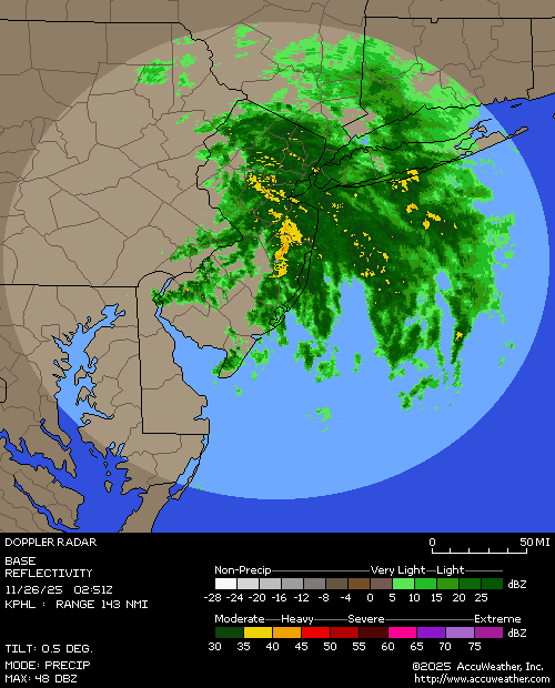
Heavy rain here
-

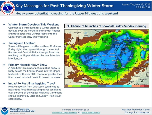
Nov 28-30th Post Turkey Day Wintry Potential
RogueWaves replied to Chicago Storm's topic in Lakes/Ohio Valley
Welcome to that 70's show -
Just flipped to snow here. Still thinking 3-4” with a solid ice/slush base from the 0.36” of rain earlier
-
I’ve seen rug pulls happen even closer to the event than 3 days before.
-

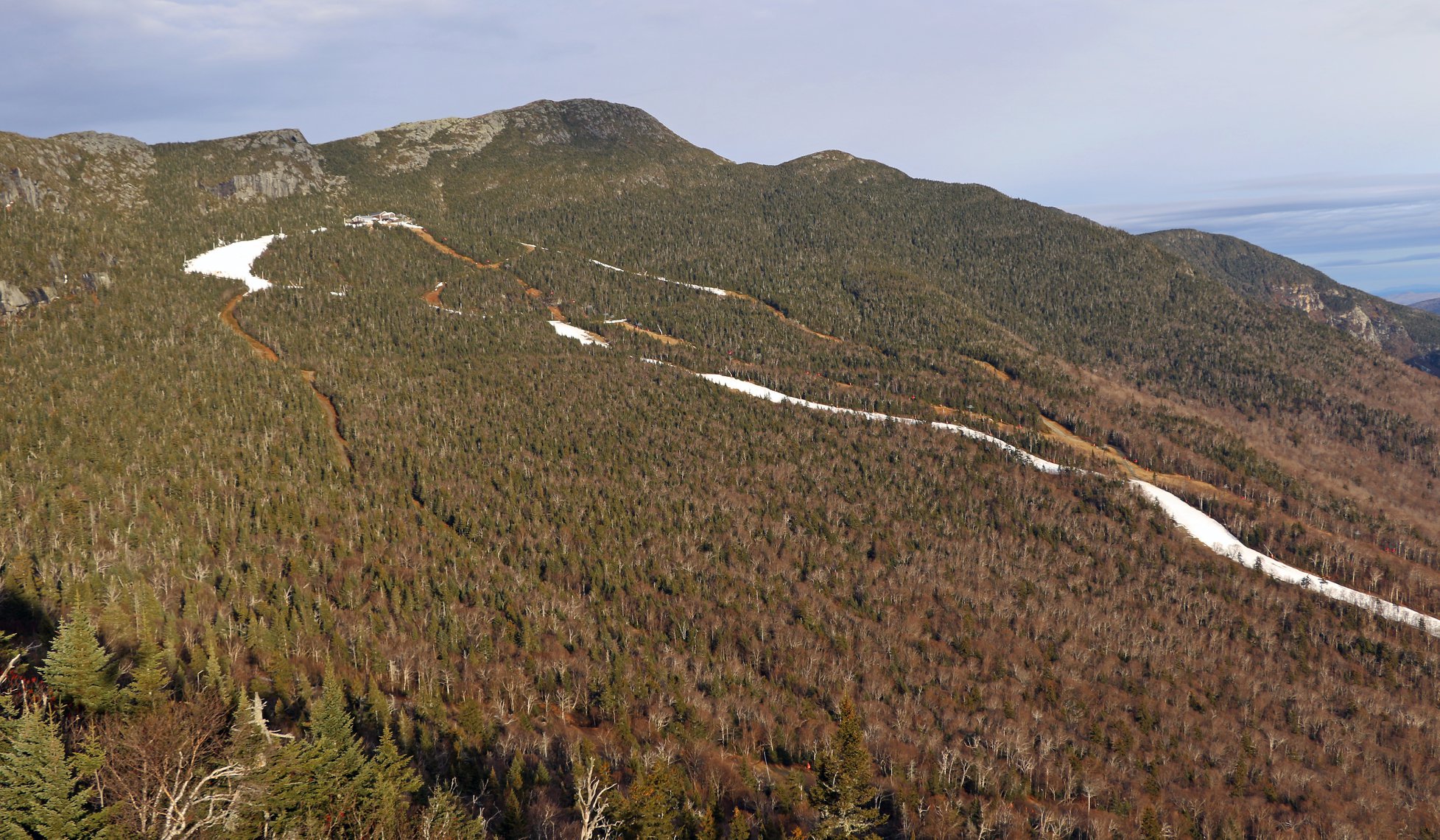
December 2025 regional war/obs/disco thread
powderfreak replied to Torch Tiger's topic in New England
That is a crazy sequence of events in the final week to Christmas. Is it better to have loved and lost, than not have at all? This was 2015 Stowe/Mansfield on Christmas Day. Only Xmas Day since 1954 with no snow on the ground at the Co-Op stake. This November reached a higher snow depth than was seen at any point during that 2015-16 winter.
- Today
-
Nov 28-30th Post Turkey Day Wintry Potential
snowman33 replied to Chicago Storm's topic in Lakes/Ohio Valley
Climo wise, this time of year you'd expect these systems to cut hard and drop heavier snows across the Great Plains. I can't recall seeing a setup just like this in a long time with the antecedent trough over the Great Lakes. -

Nov 28-30th Post Turkey Day Wintry Potential
sbnwx85 replied to Chicago Storm's topic in Lakes/Ohio Valley
-

Fall/Winter Banter - Football, Basketball, Snowball?
John1122 replied to John1122's topic in Tennessee Valley
Looks like we may play Kansas in the 3rd place game, due to the margin of victory metric in play. -
0.36 so far