All Activity
- Past hour
-
For those interested in space weather, G3 conditions possible late Tuesday night into early morning Wednesday with KP index forecasted as 7+. Not unlike the most recent snow event, a lot of variables at play to determine visibility of aurora. And we won’t really know a lot until game time. But nonetheless, potential is there.
-
According to future radar if we are going to see a chance for a period of light snow it will be between 3-430am
-
Have gotten 2" so far, with 1.7" of that last night into this morning. This event has been pretty whelming if not on the underwhelming side. A few spots did ok, it looks like Geauga County did decently this evening. However, the carpet bomb winter storm watch for 5-10" did not work out.
-
Returns starting to blossom north of Greensboro
-

Central PA Fall Discussions and Obs
canderson replied to ChescoWx's topic in Upstate New York/Pennsylvania
Already 31 at 10:30. -
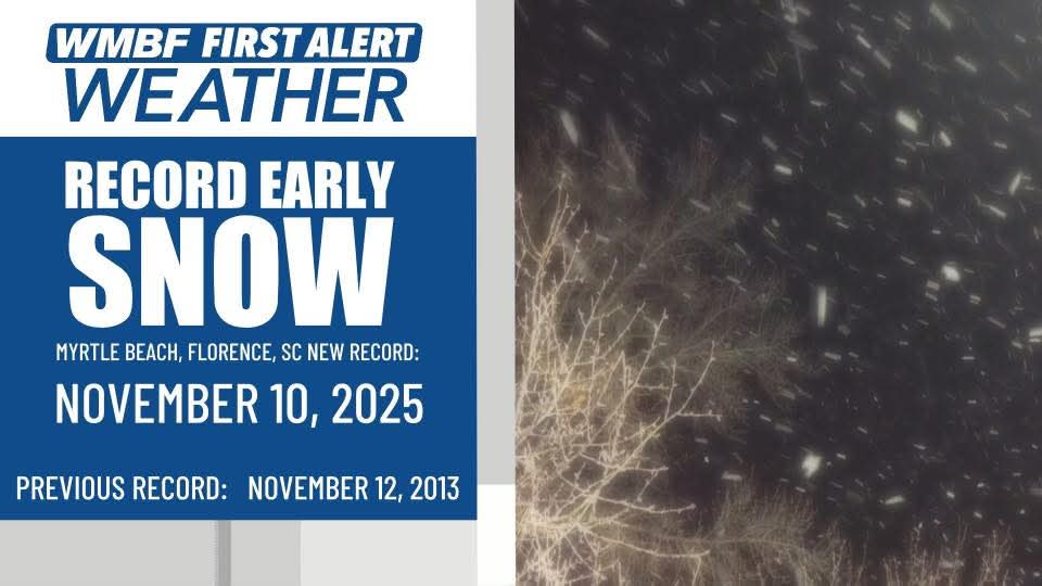
Snowing in...myrtle beach
-
Wow! I have 7.5 inches (at least) and drifts to 15 inches at my house in the Roan highlands. I am just under 3800 feet in elevation but we do well in NW flow. its still absolutely ripping.
-
A few flakes --- small, here now. Wind is whipping pretty good.
-
Accumulating snow south of Charlotte on November 10 is beyond rare
-

Central PA Fall Discussions and Obs
mahantango#1 replied to ChescoWx's topic in Upstate New York/Pennsylvania
SNOW SQUALL WARNING NWS STATE COLLEGE PA 959 PM EST MON NOV 10 2025 PAC027-033-110400- /O.NEW.KCTP.SQ.W.0019.251111T0259Z-251111T0400Z/ 959 PM EST MON NOV 10 2025 Centre County-Clearfield County- The National Weather Service in State College PA has issued a * Snow Squall Warning for... Southwestern Centre County in central Pennsylvania... Central Clearfield County in central Pennsylvania... * Until 1100 PM EST. * At 958 PM EST, a dangerous snow squall was located along a line extending from Brockport to Lecontes Mills to Stormstown, moving east at 5 to 10 mph. HAZARD...Intense bursts of heavy snow. Gusty winds leading to blowing snow and visibility rapidly falling to less than one-quarter mile. Wind gusts up to 35 mph. SOURCE...Radar and webcams. IMPACT...Travel will become difficult and potentially dangerous within minutes. For those driving on Interstate 80, this includes areas between the Dubois and Milesburg exits, specifically from mile markers 97 to 148. This includes Interstate 99 between mile markers 58 and 80, and near mile marker 84. Locations impacted include... State College, DuBois, Clearfield, Bellefonte, Sandy, Park Forest Village, Philipsburg, Woodland, Curwensville, Stormstown, Lemont, and Houserville. PRECAUTIONARY/PREPAREDNESS ACTIONS... Reduce speed and turn on your hazard lights! During snow squalls, the visibility may suddenly drop to near zero in whiteout conditions. Serious injuries and deaths may result from people exiting their vehicles during a snow squall. Drivers may not be able to see you or stop! If you have been involved in an accident or pulled to the side of the roadway, quickly exit your vehicle and move as far away from the roadway as possible ONLY when it is safe to do so. Do not stand along or near the roadway, since approaching vehicles may be unable to maintain control. LAT...LON 4120 7872 4122 7865 4125 7863 4115 7815 4093 7773 4074 7783 4069 7795 4106 7879 4114 7880 4120 7872 SNOW SQUALL...OBSERVED -
Several flakes have fallen.
-
Great song!!!!
-
 Essex County…NY?
 -
Flurries in North Myrtle Beach
-
-
-

Pittsburgh PA Fall 2025 Thread
blackngoldrules replied to TheClimateChanger's topic in Upstate New York/Pennsylvania
And, so far, the models seemed to be right. Had a hole over the Pittsburgh area, and looking at the radar, that's where it is. Lol Sent from my SM-S931U using Tapatalk -

November 2025 general discussions and probable topic derailings ...
tavwtby replied to Typhoon Tip's topic in New England
basically had a flash freeze here after a pleasant temp day, saw first flakes, just a couple randos, but has a good cold feel out there...on a side note, my anemometer intermittently has stopped working so I don't know what speed gusts are etc, sucks I can't afford another station.
-
-
4” reported NW of SLK.
-
I grew up in NW Ohio. Heard this song a lot.
-
MPing reports almost to MYR too.
-
Not thinking more than a coating is possible here, but boy has it turned chilly! Currently 25.8/14.9 with a NW wind 15 gusting to 27. That makes the WC 14/10. There are still a few flurries flying about.
-
-
 You mean the Deep South seeing flakes before SNE doesn’t do it for you? it’s easier at this point to just accept it’s not going to snow, and if it happens, be pleasantly surprised