All Activity
- Past hour
-

July 2025 Obs/Disco ... possible historic month for heat
weathafella replied to Typhoon Tip's topic in New England
That’s cranky. -

July 2025 Obs/Disco ... possible historic month for heat
Typhoon Tip replied to Typhoon Tip's topic in New England
Other than he should be looking at the wave frequency along the interface latitudes of the HC's termination into the westerlies, and not above the polar jet at this time of year ... , sure -

July 2025 Obs/Disco ... possible historic month for heat
Torch Tiger replied to Typhoon Tip's topic in New England
Ha I saw that, how unlucky -

July 2025 Obs/Disco ... possible historic month for heat
Sn0waddict replied to Typhoon Tip's topic in New England
A random cell is just training over me right now. So much for mowing the yard today, wtf. -

July 2025 Obs/Disco ... possible historic month for heat
Baroclinic Zone replied to Typhoon Tip's topic in New England
89F -

2025-2026 ENSO
CP_WinterStorm replied to 40/70 Benchmark's topic in Weather Forecasting and Discussion
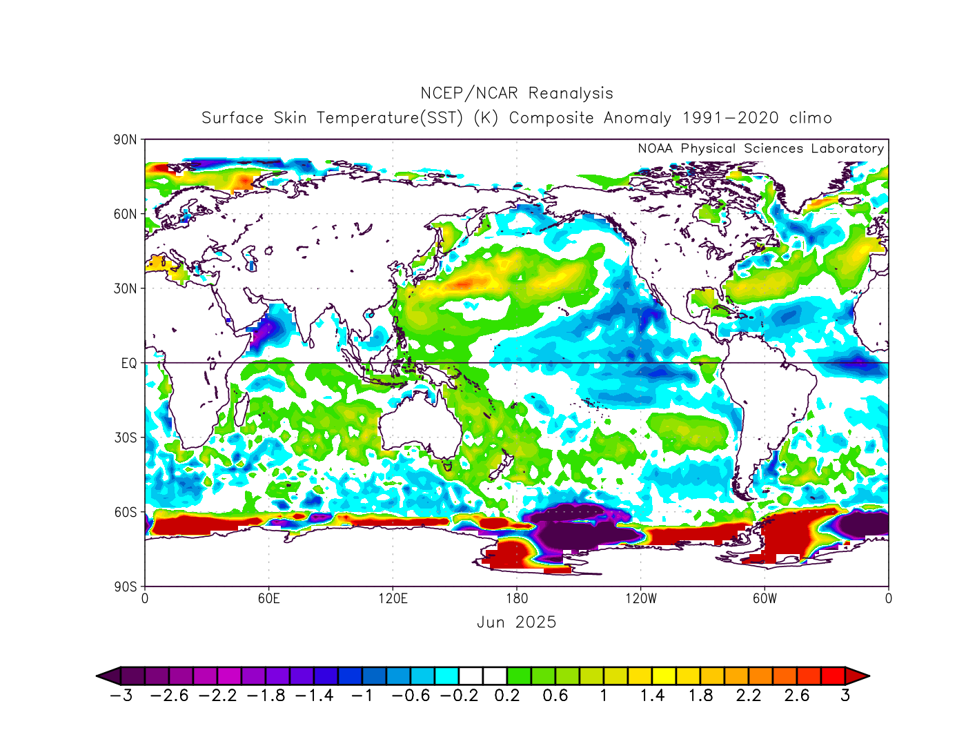
For those who are smarter than I, does the setup of the PDO make a difference? What I mean by this is, the current event seems to be driven more by the western Pacific anomalies than the eastern Pacific... June 2025: June 2011: Does the fact that this -PDO is being driven largely by the strength of the warm anomalies make any difference compared to -PDOs like 2011 where it's the cold anomalies? Anyone know?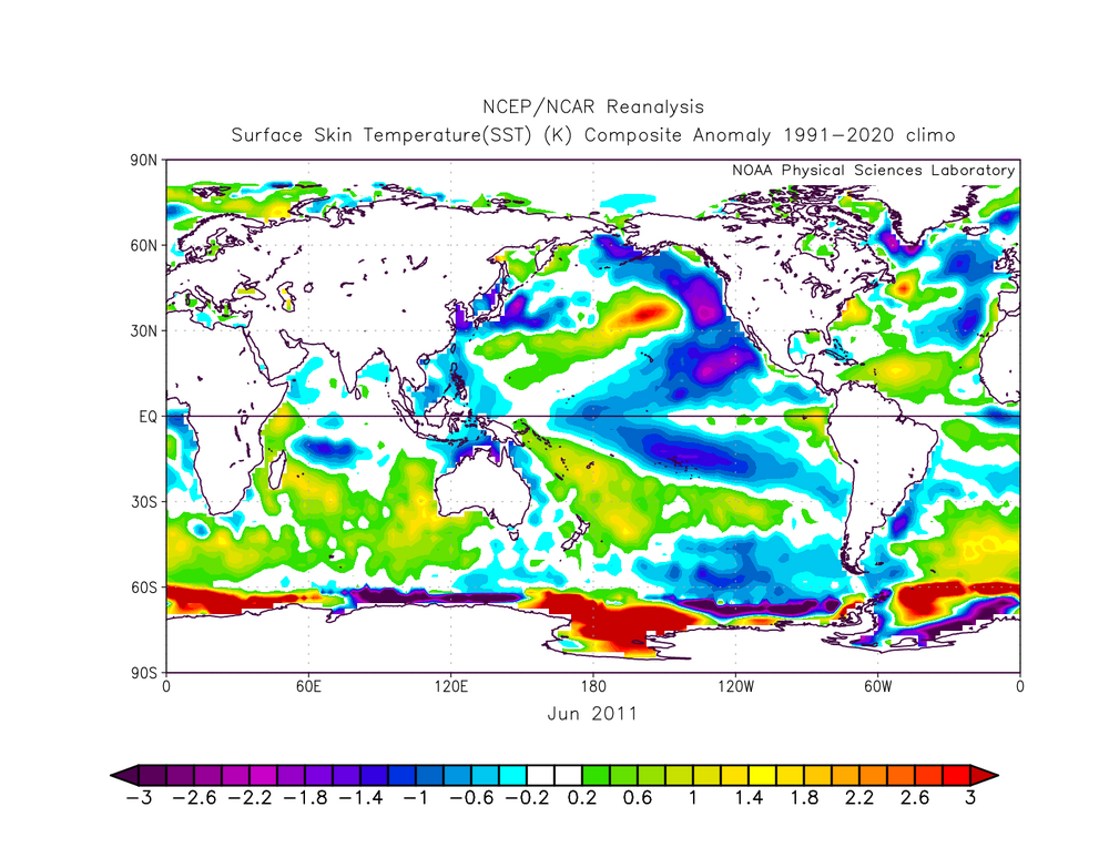

-

July 2025 Discussion-OBS - seasonable summer variability
donsutherland1 replied to wdrag's topic in New York City Metro
Generally warm weather will prevail through Saturday. New York City will see highs in the middle to perhaps upper 80s during this stretch. Parts of the region could experience some thunderstorms tomorrow afternoon or evening. After that, the next rainfall will likely occur during a frontal passage early next week. Excessive heat does not appear likely to return through at least the first week of July. There remains some potential for a shot of more significant heat during the July 6-8 period. The worst of the heat, should it develop, will likely occur away from the coastal plain. The ENSO Region 1+2 anomaly was +1.0°C and the Region 3.4 anomaly was 0.2°C for the week centered around June 18. For the past six weeks, the ENSO Region 1+2 anomaly has averaged +0.47°C and the ENSO Region 3.4 anomaly has averaged -0.03°C. Neutral ENSO conditions will likely continue through at least late summer. The SOI was +7.32 today. The preliminary Arctic Oscillation (AO) was +1.176 today. -
85/71 is so much better for softball than 95/77 like last week
-

July 2025 Discussion-OBS - seasonable summer variability
bluewave replied to wdrag's topic in New York City Metro
Tree ring studies suggest that the 1960s were rated as a 500 year drought. Something that hasn’t been able to repeat in this much warmer climate with increased moisture. So we have been spared peak highs in the 110° to 115° range which would occur here with the much warmer climate of today and 1960s drought and westerly flow. https://ocp.ldeo.columbia.edu/res/div/ocp/glodech/PDFs/Pederson_etal_NYCdrought_revised.pdf -
The lack of rain is getting tiresome.
-

2025-2026 ENSO
brooklynwx99 replied to 40/70 Benchmark's topic in Weather Forecasting and Discussion
wouldn't be surprising if we had another -EPO dominant winter with intervals of blocking. still some -PNA, obviously. likely AN temps in the mean, but we'll probably have some colder intervals with blocking... overall, doesn't seem like too much of a deviation from last winter's vibe, which I would run back and see if the dice can roll a bit better - Today
-
All packed up to head up to the cabin early tomorrow morning. Highs in the 70s, lows in the upper 50s, low DP...gonna feel like October. Spent all day down here putting out moth eggs and lost about 5lbs in sweat. At least I don't get mosquito bites.
-

July 2025 Obs/Disco ... possible historic month for heat
metagraphica replied to Typhoon Tip's topic in New England

-
I wound up having 3 storms roll over my house and got 3.12" yesterday. That is more than I received during the entire month of June (2.72"). My yard was starting to bake in the Summer heat but this should help it out for at least a week.
-

July 2025 Obs/Disco ... possible historic month for heat
kdxken replied to Typhoon Tip's topic in New England
It's over... -
You're gonna love what's coming this fall and winter.
-
Wanted to say that it was really nice to finally meet @Ellinwood the other day. Hopefully you don't sleep through any more big storms!
-

July 2025 Obs/Disco ... possible historic month for heat
Chrisrotary12 replied to Typhoon Tip's topic in New England
Disgusting outside. Every article of clothing stuck. Sweating dripping everywhere. Can’t hold on to the golf club. Where’s the dry heat? -
0.53 in Fuquay Varina. Grass really needed it! 80.4 the high so far. Thanks to sun the last hour.
-

July 2025 Discussion-OBS - seasonable summer variability
JonClaw replied to wdrag's topic in New York City Metro
SPC has NYC square in the center of slight risk tomorrow. 12z NAM has a line coming through around 7pm.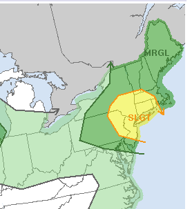
-
Don't know if anyone noticed or if it's been posted previously, but cyclonicwx.com now offers some decent OISST worldwide SST and SSTA graphs for the last 10 years that make for easy reference with each area broken down separately. https://cyclonicwx.com/sst/ Click on "OISST" in the banner near the top.
-

July 2025 Obs/Disco ... possible historic month for heat
weatherwiz replied to Typhoon Tip's topic in New England
Not entirely shocked at the slight risk designation. We've had some worse setups get a slight risk designation That is a really well-defined s/w trough moving into the region with good height fields and increasing dynamics with cooling aloft. I would be shocked if storms aren't numerous tomorrow and evolve into multiple short-line segments or clusters -
July 2025 Obs/Disco ... possible historic month for heat
metagraphica replied to Typhoon Tip's topic in New England
Had a few rumbles in January? February? but nothing since then. Yesterday was just intermittent light rain over 12+ hours. Want a nice gully washer. 1 or 2 inches in 30 minutes type of storm!! -

July 2025 Obs/Disco ... possible historic month for heat
DavisStraight replied to Typhoon Tip's topic in New England
Like last night? I wasn't expecting anything yesterday and the minute I walked outside with the dog the skies opened up and heard a loud boom, dog went back in quickly. -
July 2025 Obs/Disco ... possible historic month for heat
metagraphica replied to Typhoon Tip's topic in New England
Let's dew it. Doesn't have to be severe imby. Just some good heavy rainers with a few rumbles would be great.