All Activity
- Past hour
-

Richmond Metro/Hampton Roads Area Discussion
jlewis1111 replied to RIC Airport's topic in Mid Atlantic
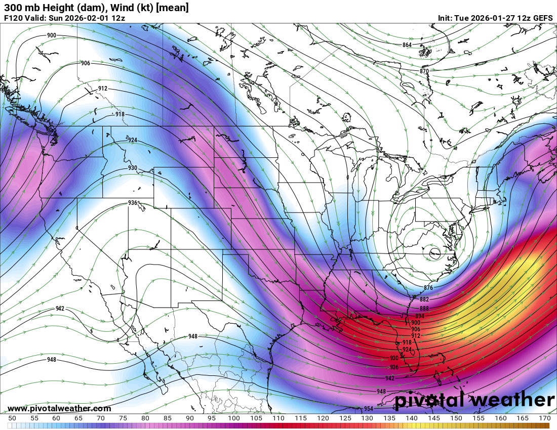
I disagree I think oddly enough that the NAM did the best as it sniffed out the north jump first -

The “I bring the mojo” Jan 30-Feb 1 potential winter storm
wncsnow replied to lilj4425's topic in Southeastern States
Fine you asked for it.thumb.png.8a27c05139a8d4d0dfc62082db5f9ec3.png)
-
27 here, wondering if we get above freezing today
-
Does it usually set up where you have greater difference aloft?
-
Noon
-

Possible coastal storm centered on Feb 1 2026.
Wxbear25 replied to Typhoon Tip's topic in New England
Yup! Now overlay that with the surface low and you’ll see how well it correlates with the left-exit of that powerful streak -
The suffering is half the fun!
-
Agreed. I just think its tough because we know it's an estimate and not an actual measurement. Thus the range that really doesn't exist in certain events. I think they were 13-20" for this storm (10-14" and 3-6"). Count the 20" in the season total.
-
It really only won it on thermals not much else, lol
-
-

The “I bring the mojo” Jan 30-Feb 1 potential winter storm
StantonParkHoya replied to lilj4425's topic in Southeastern States
Can someone post the UKMET? For what some call OTS means coastal/ENC snow. -

Pittsburgh/Western PA WINTER ‘25/‘26
colonel717 replied to Burghblizz's topic in Upstate New York/Pennsylvania
Hope this doesn't move through quickly. Mod/heavy now -
Lol "new" way?
-
Complicated might be the new way we get snow now. I’m in.
-

Possible coastal storm centered on Feb 1 2026.
Ginx snewx replied to Typhoon Tip's topic in New England

-
Edits for the next storm.
-

E PA/NJ/DE Winter 2025-26 Obs/Discussion
Chadzachadam replied to LVblizzard's topic in Philadelphia Region
13/30 GFS ensemble members were a big hit for SEPA. think this is kind of an all or nothing deal with the complex dynamics, although it is possible we could pick up a couple fluffy inches in some of the OTS scenarios. random question but any chance we get dry enough for some of the existing snowpack to sublimate this week? -
I have watched different movies with those last 3 words.
-
If the last system shifted north, we are due this one shifting more to the west by Thursday.
-
 Do you harangue them from the derelict driveway?
 -

Possible coastal storm centered on Feb 1 2026.
dryslot replied to Typhoon Tip's topic in New England
Yup, That's why i had mentioned the delmarva give or take. -
NAM sorta kinda won the last storm maybe we are working our way up from the bottom as far as winners for each storm. GFS is next up!!
-
GFS first taketh and wrongeth, then GFS giveth
-
Out to hour 6, we are cooked. Well that was fast
.png.71f119cfc4e659a10d3d2bf9d9fe2712.png)