All Activity
- Past hour
-
It rained so close I could smell the petrichor but nothing fell here.
-
Garden variety heavy rain in Odenton.
-
Yeah hoping for some dry nw wind heaters!
-
18Z NAM and RRFS-A (I know, I know, but they're the only mesoscale models that go out that far) edged a little bit north with the warm sector for Wednesday evening.
-
Looks like a cape special late. 3-6am?
-
Today's Highs EWR: 94 PHL: 93 BLM: 92 TEB: 91 New Brnswck: 91 TTN: 91 LGA: 90 ACY: 89 ISP: 87 NYC: 87 JFK: 86
-
A spectacular rainbow this evening. Sent from my SM-G998U using Tapatalk


-

2026 Mid-Atlantic Severe Storm General Discussion
wxmeddler replied to Kmlwx's topic in Mid Atlantic
Poppin off. Sunset magic hour. Boundary layer decouples and you get a stray gust front (La Plata storm) or subtle s/w aloft and go time.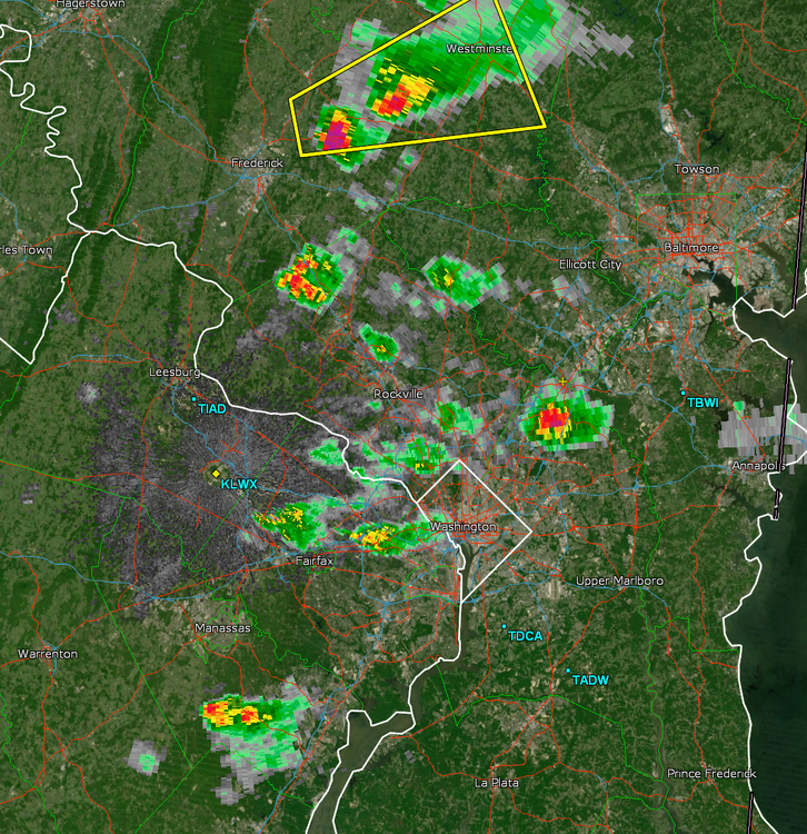
- 724 replies
-
- 1
-

-
- severe
- thunderstorms
- (and 7 more)
-
I was rummaging through the NWS surface forecast map page, wanted a primer on the symbols and this is what they link for that: https://www.wpc.ncep.noaa.gov/html/fntcodes2.shtml
-

2026 Mid-Atlantic Severe Storm General Discussion
NorthArlington101 replied to Kmlwx's topic in Mid Atlantic
Yep, trying to pop off a bit. Wouldn’t mind a little storm tonight to end the weekend.- 724 replies
-
- 1
-

-
- severe
- thunderstorms
- (and 7 more)
-
Today's Highs EWR: 94 PHL: 93 BLM: 92 TEB: 91 New Brnswck: 91 TTN: 91 LGA: 90 ACY: 89 ISP: 87 NYC: 87 JFK: 86
-

2026 Mid-Atlantic Severe Storm General Discussion
MN Transplant replied to Kmlwx's topic in Mid Atlantic
Bit of initiation happening west of DC from the outflow from the earlier southern storms.- 724 replies
-
- 1
-
-
- severe
- thunderstorms
- (and 7 more)
-
Played golf in Lakeville Ma today. Heard a lot of " Mother effers!" "I got one in my eye!" " "Pffft pffft pfft spit"
-
Daily red flag warnings incoming?
-
Is that your point of view?
-

2026 Mid-Atlantic Severe Storm General Discussion
Eskimo Joe replied to Kmlwx's topic in Mid Atlantic
Impressive LSR out of Grafton, WV for that western line "Sustained 35 mph for 5 minutes with gusts to 62 mph."- 724 replies
-
- 1
-
-
- severe
- thunderstorms
- (and 7 more)
-
2026 Mid-Atlantic Severe Storm General Discussion
wxmeddler replied to Kmlwx's topic in Mid Atlantic
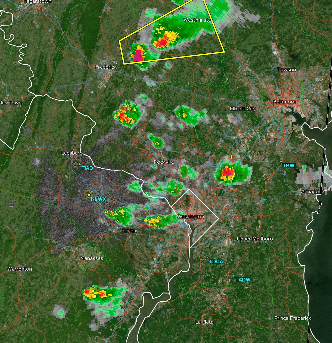
BWER on the E Frederick / W Carroll Cell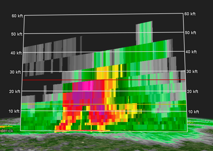
- 724 replies
-
- 2
-
-
- severe
- thunderstorms
- (and 7 more)
-
2026 Mid-Atlantic Severe Storm General Discussion
wxmeddler replied to Kmlwx's topic in Mid Atlantic
There's nothing nearby, it's just the sfc parameters are still juiced. I think the lack of convection SW of DC is due to earlier showers in SW VA that had the area in cloudcover most of the afternoon. The sfc never quite destabilized enough down that way for sfc based convection to take hold.- 724 replies
-
- 1
-
-
- severe
- thunderstorms
- (and 7 more)
-
2026 Mid-Atlantic Severe Storm General Discussion
Eskimo Joe replied to Kmlwx's topic in Mid Atlantic
There's gotta be something nearby. That cell in York County went nuts in like 3 frames. -
Now a total of 49 (unfiltered) or 44 (filtered) tornado reports are on the list for 6/11
-
2026 Mid-Atlantic Severe Storm General Discussion
wxmeddler replied to Kmlwx's topic in Mid Atlantic
The CAM's really gusted out / crashed the surface parameters by this time and by looking at surface obs, that is just not the case. We have not overturned at all in the DC Metro. There's a lot of sfc energy still bouncing around. -
I'm with you. It cant rain here anymore, You must be in downtown Raleigh and pts north and east and south to get rain I guess.
-
Once again Upton overdid the forecast here for rain. Same as on Thursday and Friday.
-
2026 Mid-Atlantic Severe Storm General Discussion
Eskimo Joe replied to Kmlwx's topic in Mid Atlantic
Interesting little cell near Walkersville in Frederick County.


.thumb.gif.f92b16c631a1d15d405ed77b33f0710d.gif)