All Activity
- Past hour
-

Central PA Winter 25/26 Discussion and Obs
GrandmasterB replied to MAG5035's topic in Upstate New York/Pennsylvania
I remember the modeling really hitting the sharp cutoff in the lead up to that event. It pretty much verified just a bit further north. This one is not currently modeled as extreme a cutoff as that event. Another positive that’s already been mentioned is the ratios will help us up here too. So I’ll be trying not to live and die with the QPF output, but will end up doing just that anyway. Will be a long week for sure. -

January 2026 regional war/obs/disco thread
UnitedWx replied to Baroclinic Zone's topic in New England
1/2" in Sims and Westfield -
I learned from DT way back when that you don't go against the E/E rule.
-
100% yes. The movement north is not a big concern like stated. it will be the upper level warmth base on strength of the LP moving through. Lots to be ironed out for sure.
-
21.1" here for the season.
-
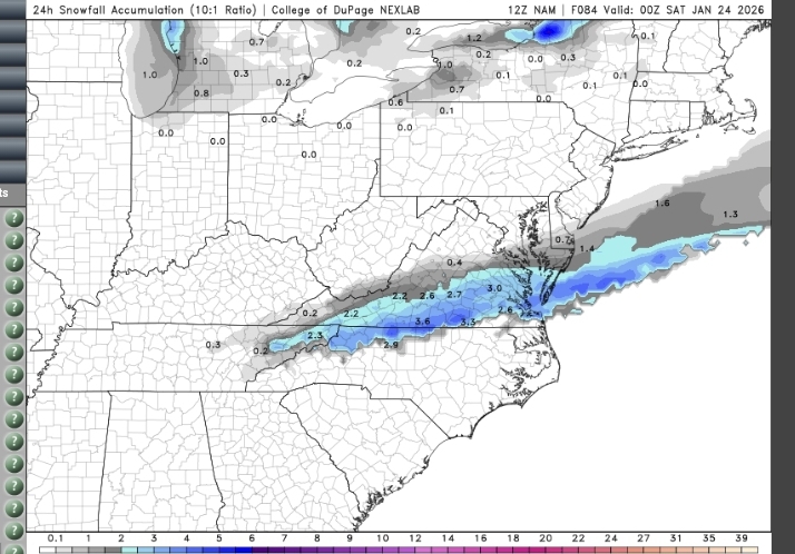
Let's keep it right where it is ... Although there's something to be said for sleet, in that it keeps snowpack around for a while. I got 4" snow and sleet in Jan 2022, and it stuck around for two weeks. Also the last two runs of the (fantasy range) NAM have shown a weak disturbance bringing some snow to the VA/NC border and north on Friday. There was some support for the idea on the Euro, otherwise I wouldn't be talking about it @BornAgain13

-
2F with wind chills hovering at -15 to -20 at DTW this morning. Looks tundra-like outside with the frozen, drifted landscape and the weak looking sun.
-
E/E rule!
-

Possible Record Breaking Cold + Snow 1/25 - 1/26
CPcantmeasuresnow replied to TriPol's topic in New York City Metro
A lot of family in north Georgia Alpharetta area. As depicted this would be catastrophic. Doubt it reaches these levels but... -
Sorry to hear that man. 8 years is a long time and there are many other companies that will value you and what you bring to the table.
-

Possible Record Breaking Cold + Snow 1/25 - 1/26
vegan_edible replied to TriPol's topic in New York City Metro
if this verified i can't fathom the level of disaster this would cause for anyone who cares (no one) i changed my flight to saturday. while you are all *potentially* seeing our first major storm in a long time, i will be in the warm embrace of southern californias never ending sunshine. will be watching the board to see how we make out. lets hope we get some snow and more comes in feb! -

January 2026 regional war/obs/disco thread
Cyclone-68 replied to Baroclinic Zone's topic in New England
Is it correct to assume whoever ends up getting nailed with this that the “B” word will be used? -

January 25/26 Jimbo Back Surgery Storm
NorthHillsWx replied to Jimbo!'s topic in Southeastern States
Fact that is EPS inside 4 days and not some random 300 hour GFS run is absurd -
Awesome trip down memory lane - this was the 10-year anniversary thread, some potential similarities, though I think the cold air we are working with in January is much denser than December. The changeover is inevitable with this powerful a system, and I personally believe the freezing rain line will be somewhere in Greenwood, SC. I just can't see these more northern ZR numbers verifying, not in January with this strong of a high. But it's a SE winter storm, so all cards are always on the table.
-

Richmond Metro/Hampton Roads Area Discussion
wasnow215 replied to RIC Airport's topic in Mid Atlantic
I remember the 2016 storm-I was working that evening the day it started in Hopewell. Started as all snow, then it went to sleet for several hours and then back to all snow and like another 8" where I lived in Glen Allen. Could happen this way again -

January 2026 regional war/obs/disco thread
Sugarloaf1989 replied to Baroclinic Zone's topic in New England
Two coldest days were at Sugarloaf. December 1989 about -40F and January 2009 with my son. -27F on the car thermometer at Stratton Maine and -35F at Sugarloaf Summit. Skiing with any speed caused chest pain from the cold. -

Central PA Winter 25/26 Discussion and Obs
Eskimo Joe replied to MAG5035's topic in Upstate New York/Pennsylvania
Saw a couple questions about blizzard potential. We'd need a coastal to rapidly deepen as it pulls away. None of the guidance currently suggests that, so it looks like that is off the table with this event. -
January 25/26 Jimbo Back Surgery Storm
NorthHillsWx replied to Jimbo!'s topic in Southeastern States
This is literally the type of storm the NAM was built for. NAM will be the most watched model starting tomorrow night -

Winter cancelled/uncancelled banter 25/26
Tar Heel Snow replied to Rjay's topic in New York City Metro
Well that’s straight up concerning. I do not like where we are rn. Know better than to overreact to where things stand at D3+, but with how relatively steady most models have been, I’d like to start seeing more movement in our favor soon. Parents back in central NC might get their most snow since January 2000 -

January 2026 regional war/obs/disco thread
weatherwiz replied to Baroclinic Zone's topic in New England
Which I don't think should have been a big surprise. That's how these setups tend to typically evolve. This is a setup in which I am very curious how the AI camp would perform...there is alot of physics at play here and even the traditional modeling can struggle in that sense...not to the fault of the models but more of a product of just a lack of more powerful computing (que quantum computing). If I had to guess, I think we continue seeing more bumps...I don't see a whole lot arguing for keeping this too far south (big change from what I was thinking a day or two ago). -

E PA/NJ/DE Winter 2025-26 Obs/Discussion
zenmsav6810 replied to LVblizzard's topic in Philadelphia Region
I'm thinking that the high pressure is a bit overdone. I personally think this is more of a blend between PDII and Dec 2000. Plenty still can go wrong. A few days ago I thought the GFS was showing more of a Miller C setup but now it shows more of a Miller B look. PDII had a pretty organized precip shield but we still ended up with a bit of a dry slot about 2/3rds of the way through the storm even as NW as berks county. I think the QPF was a bit higher with PDII overall too. -
Yeah, we will all be sleeping downstairs during this event, unless the expected mix line ends up way south of us.
-

Possible Record Breaking Cold + Snow 1/25 - 1/26
kat5hurricane replied to TriPol's topic in New York City Metro
PDII was a two part system but, yes, it's rare to get a two part wallop at the coast especially -

Central PA Winter 25/26 Discussion and Obs
mahantango#1 replied to MAG5035's topic in Upstate New York/Pennsylvania
another good video. there are a lot of answers to be determined yet https://x.com/AccuRayno/status/2013605353305317530?s=20 -
Richmond Metro/Hampton Roads Area Discussion
Ephesians2 replied to RIC Airport's topic in Mid Atlantic
Last two runs of the (FANTASY RANGE) NAM have shown a disturbance to our south on Friday. There was some support for the idea on the Euro too.