All Activity
- Past hour
-
It has been kinda dry. I biked over at Little Bennett yesterday and aside from two spots in a sort of valley part of the trail, it was actually really nice riding conditions. Just got a little shower moving through here. Kind of annoying because I have off today...hoping it clears up a bit this afternoon.
-
Sun breaking through and we’re up to 64 already.
-
2002 was a very warm summer, but the 02-03 event was a moderate, as it didn't quite peak at above 1.5 on the ONI/RONI. 2009 wasn't warm, and in fact, one of the coldest June/July. 2015 was slightly warmer than normal, but 2016 was much warmer. 2014 was the cool summer, and you could technically count that as the pre-nino summer if you consider 14-15 (borderline warm neutral/weak el nino) as part of the el nino event. Almost all 1.5+ peak seasons have warmer post-nino summers than pre-nino summers, with the exception of the Pinatubo case in 91-92.
-
If you don't get a shower today, maybe you will get lucky on Friday. WB 6Z EURO.

-

2026-2027 El Nino
michsnowfreak replied to Stormchaserchuck1's topic in Weather Forecasting and Discussion
Other than that one article that is shared over and over by the same people, we have no idea what went into measuring at every location pre-1950. I think actually 1948 is when the 6 hr started at airports. That is also when they started rounding up daily snow depth to nearest inch. I have done plenty of local research on past weather events and while human error was there in 1880 and is there in 2026, I am pretty confident in the snow record at Detroit (and most other 1st order stations) being quite accurate. Now, coops and NON first order, who knows and there are undoubtedly tons of error. Back in the 1800s and very early 1900s they would always say "10 inches of snow fell on the level" or something like that. They applied a 10-1 ratio usually. But it would make more sense to apply a 10-1 ratio to what you measured than to melt snow down for a liquid and apply the ratio to snow. Its a hell of a lot easier measuring snow than it is melting it down for liquid equivalent. -
Sun beginning to peek out here.
-
Yep! Nothing structural was damaged. Only charred up some brush and wooded sections.
-
97 was not bad, but that was probably because relative to 96 it had way more 90 degree days, but it was at least normal. Most of the El Nino summers though were not mild. 2002/2009/2015 I don't believe were either.
-
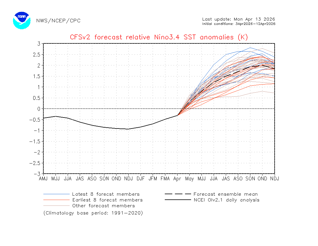
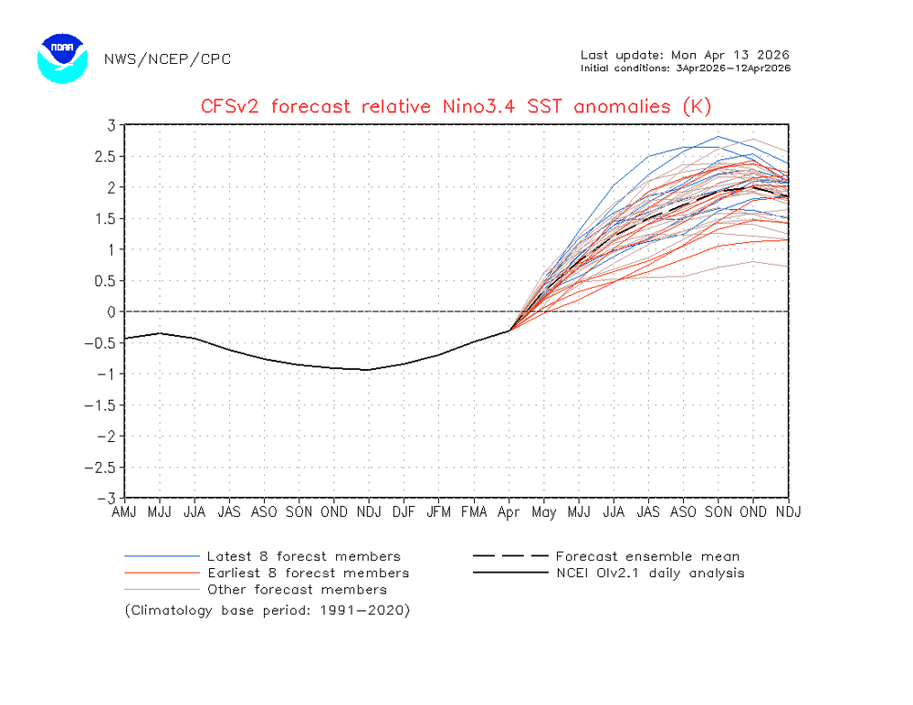
Latest 10 day CFSv2 ensemble mean forecast of RONI: +2.0 peak OND. Note that unlike the BoM’s nearly impossible +0.6 for April, this has a much more sensible -0.3:
-
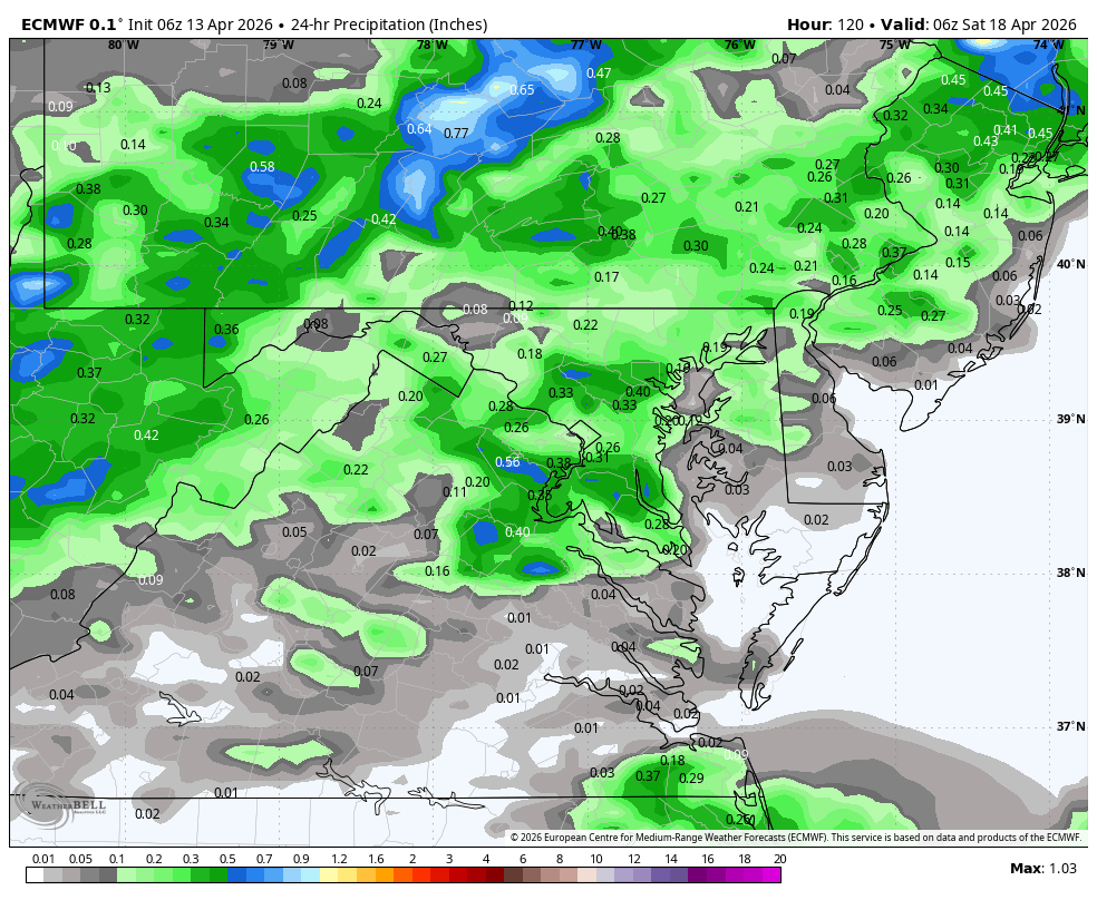
Most of that QPF comes in the 11-15 day period, which is of course the least accurate. I've seen so many CPC 8-14 day heavy rain outlooks bust. True they are mostly slight risk, which don't even make the composite chart, but the SER just won't break.
-
riding ^
-
And no sign of a breakdown in this pattern for the next 2 weeks. It's one thing to experience summer onset drought after planting and growing season but during planrting and growing season is disastrous. Feel for the farmers in my area...
-
Yeah the models are already backing off. Sigh.
-
Yeah, it had to have either been 96 or 97. Both were really cool summers (followed 3 very hot summers). JJA averages (PHL) 1993: 78.2 1994: 78.4 1995: 78.6 1996: 74.0 1997: 74.2
-
Severe season in the South is captured in the classic John Candy Vacation quip. Sorry folks park's closed. Cannot find the GIF on any source. Must be licensing BS. Anyway the cancellation is good news for those with storm anxiety. CFS wants to get into more active phases, but the EC and GEFS weeklies don't seem interested. We'll see.
-
Boring, allergy-laden weather, lovely…fire danger increasing too
-
May get some decent hailers today in this area.
-
Strange light droplets falling out of the sky....anyone know what it is?
-

2026-2027 El Nino
40/70 Benchmark replied to Stormchaserchuck1's topic in Weather Forecasting and Discussion
I see your point, but I have a couple counters that you neglect to consider. I know for a fact that modern snowfall measuring techniques are not homogeneous....secondly, while I do agree that the 6 hourly method does increase totals on average because it's actually measuring snowfall, which is different from to snow depth, there are some mixed precipitation events in which it will not. -
43F. Maybe 70 tomorrow, otherwise 50s to low 60s with lots of clouds/shwrs this week.
-
2026-2027 El Nino
40/70 Benchmark replied to Stormchaserchuck1's topic in Weather Forecasting and Discussion
It's because the warming of the western Pacific has outpaced eastern Pacific, which fosters a cool ENSO paradigm. -
Clearing to our west we'll jump once that comes in
-
2026-2027 El Nino
40/70 Benchmark replied to Stormchaserchuck1's topic in Weather Forecasting and Discussion
Weak-moderate is absolutely better than strong in my region. -

Let’s talk winter!! Ohio and surrounding states!! 24'-25'
buckeye replied to buckeye's topic in Lakes/Ohio Valley
Looks like we wrap up 2025-2026 with official CMH snowfall 33.9. Not bad, first above normal in awhile...and maybe for awhile longer if all these super nino predictions come to fruition. Back to the miserable winters of the late 90's. -
95 was pretty brutal maybe you're thinking of 96?