
All Activity
- Past hour
-

2026-2027 Super El Nino
Terpeast replied to Stormchaserchuck1's topic in Weather Forecasting and Discussion
Likely has something to do with that warm blob south of the aleutians. Not a typical pattern in a growing el nino, but as the NH season cools, that blob should get slowly shunted east as the north pac jet strengthens. We’ve seen the PDO dive in the spring and summer, and then slowly climb in the fall and winter, time and again and this year probably will be no exception. We may even break positive this time with the super nino.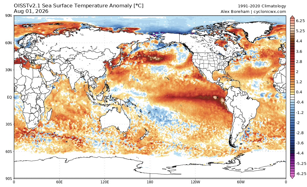
-
Yeah my station isn’t capturing the full amount for sure
-

Augdewst 2026: Summer's Last Stand
Supernovice replied to Prismshine Productions's topic in New England
Don’t give our resident moron the oxygen he needs. Just ignore his ‘weather related’ posts like everyone else and he will slowly….ever so slowly, go away. -
I had to leave town for it to finally rain. My station says 1.24”. Radar seems to think that there is upwards of 3” in spots between my house and DCA.
-
My July rain total is 6.75". My June-July rain total is 15.79".
-

2026-2027 Super El Nino
GaWx replied to Stormchaserchuck1's topic in Weather Forecasting and Discussion
The latest WCS daily PDO has fallen to -2.19, which is the lowest since way back on 8/29/25! This plunge was not predicted AFAIK: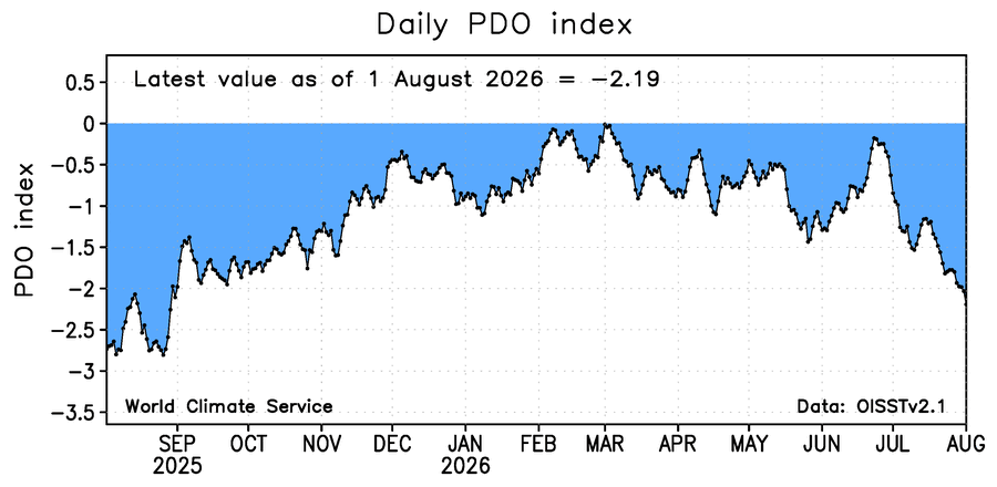
-
Touched 90 again today here in Phila. as well!
-
Feels like maybe Tuesday broke the seal for the city - getting slammed.
-
Thunder in Columbia with the start of this batch
-
Picked up .17" with this passing cell. Dew now at 81. I don't even want to take the garbage out.
-

E PA/NJ/DE Summer 2026 Obs/Discussion
JTA66 replied to PhiEaglesfan712's topic in Philadelphia Region
Been getting nickel & dimed here with rain as well the last few weeks. I’m not interested in flooding, but the lawn could use a good soaker. Kicked up a lot of dust mowing yesterday and the grass is starting to brown up again. Hit 88F today. Probably would have reached 90F both days this weekend if we had full sun. 83F/DP 67F -
Did touch 90 before more clouds came in around 4:15 or so. I see others in NJ did could be some places with a little/mini heatwave this weekend/Friday.
-
Deluge in takoma park - been a while
-
2026 Severe Wx - General Thread
CheeselandSkies replied to largetornado's topic in Lakes/Ohio Valley
500mb pattern recognition via GFS/NAM suggests something may happen Wednesday although runs differ where/if significant instability may develop given ample/persistent convection. At least could be another good soak for NW parts of the sub. -

Central PA Summer 2026 Discussion/Obs Thread
Itstrainingtime replied to Voyager's topic in Upstate New York/Pennsylvania
.03". Can't recall the last good rain here. -

2026-2027 Super El Nino
EasternLI replied to Stormchaserchuck1's topic in Weather Forecasting and Discussion
Today's run shows it well too. -
 Sildenafil 100mg price: Order Viagra 50 mg online - Generic Viagra online
 -
NAM failure
-

Central PA Summer 2026 Discussion/Obs Thread
mahantango#1 replied to Voyager's topic in Upstate New York/Pennsylvania
.89 rain today so far. -
Dumping for the second time today in silver spring. Could end up with over 2" on the day. Niño time finally here?
-
Yeah, this winter we will either hit one out of the park, or strike out spectacularly.
-
best price for viagra 100mg [url=http://medmennews.com/#]Viagra generic over the counter[/url] Viagra online price
-
Just got home after driving through heavy rain all the way through Calvert county. My rain gauge has 1.1" in it from the storms today so far. Solid drought remediation. Seems like more to come too.
-
Let’s just use pure math for now to set expectations. If we use Ninos that reached > +1.5 during winter 5/9 or 56% had a HECS. If we use years that reached > +2 during winter 2/3 or 66% had a HECS. Clearly we have a significantly elevated probability of a HECS this winter. But yes for the DEBs the caution is the years in that analog set that didn’t have an HECS were really really really awful winters for the most part.
-
Biblically the wettest start to August ever here. A harbinger of what's to come for the entire month, perhaps? 000 SXUS71 KILN 021040 RERDAY RECORD EVENT REPORT NATIONAL WEATHER SERVICE WILMINGTON OH 1039 AM EDT SUN AUG 02 2026 ...RECORD DAILY MAXIMUM RAINFALL SET AT DAYTON OH... A RECORD RAINFALL OF 2.20 INCHES WAS SET AT DAYTON OH YESTERDAY. THIS BREAKS THE OLD RECORD OF 2.19 INCHES SET IN 1953. $$
















