All Activity
- Past hour
-
Blizzard warning issued for many a week ago today
-
If we have seen the last snowfall for CPK this season, the average snowfall for this decade so far would be 20.43 The average for the 30 year period of 1970 through 1999 was 21.91 CPK is behind by 1.47 inches. The 1970s avg was 21.25. CPK is behind by 0.82 The # of above average snowfall winters from 1970 through 1999 was 4 (including 78/79 which was 29.4). CPK has already received 2 above average snowfall winters in 6 seasons this decade, well ahead of the pace. We have seen 3 <50% snowfall winters this decade. The 1970 through 1999 total was 11, CPK is ahead of that pace. Will continue to monitor.
-

"Don’t do it" 2026 Blizzard obs, updates and pictures.
MJO812 replied to Ginx snewx's topic in New England
Blizzard warning issued for many a week ago today -
(002).thumb.png.6e3d9d46bca5fe41aab7a74871dd8af8.png)
Central PA Winter 25/26 Discussion and Obs
ChescoWx replied to MAG5035's topic in Upstate New York/Pennsylvania
Today will be the warmest day of the year with highs into the mid 50's. The warmest day so far this year was 51.4 degrees on January 7th. Today will be our warmest day since the 56.6 degree reading on December 19th. To put a fine point on how unusually cold this winter has been since December 1st today will be only the 6th day to reach 50 degrees or higher. During the winter months of December through February 60 of those 90 winter days featured below normal temperatures. The warmth will be short lived as a cold front crosses the area overnight tonight. We could also see some wintry precipitation by tomorrow morning as light rain looks to transition to some freezing drizzle as temperatures fall below freezing by 7am. The freezing drizzle could end as a little light snow before ending by noon. Very cold on Monday with temperatures remaining below freezing and more snow arriving by Tuesday morning. This should change to rain by Tuesday afternoon with warmer and wet conditions through much of the upcoming work week.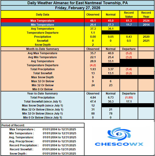
-
E PA/NJ/DE Winter 2025-26 Obs/Discussion
ChescoWx replied to LVblizzard's topic in Philadelphia Region
Today will be the warmest day of the year with highs into the mid 50's. The warmest day so far this year was 51.4 degrees on January 7th. Today will be our warmest day since the 56.6 degree reading on December 19th. To put a fine point on how unusually cold this winter has been since December 1st today will be only the 6th day to reach 50 degrees or higher. During the winter months of December through February 60 of those 90 winter days featured below normal temperatures. The warmth will be short lived as a cold front crosses the area overnight tonight. We could also see some wintry precipitation by tomorrow morning as light rain looks to transition to some freezing drizzle as temperatures fall below freezing by 7am. The freezing drizzle could end as a little light snow before ending by noon. Very cold on Monday with temperatures remaining below freezing and more snow arriving by Tuesday morning. This should change to rain by Tuesday afternoon with warmer and wet conditions through much of the upcoming work week.
-
EWR snowfall nearly double mine
-
E PA/NJ/DE Winter 2025-26 Obs/Discussion
ChescoWx replied to LVblizzard's topic in Philadelphia Region
Cyclical pattern FTW!!! -

E PA/NJ/DE Winter 2025-26 Obs/Discussion
Birds~69 replied to LVblizzard's topic in Philadelphia Region
Congrats! You will be held to a higher standard now. The peanut gallery will be on the lookout... 48F already, 10:55am, Sunny as can be... -
If we can ease out of winter would be most preferred —keep the lawn pack protected until climo eliminates risk of a hard freeze. Should that happen could make for a most beautiful April… One could wish.
-

E PA/NJ/DE Winter 2025-26 Obs/Discussion
The Iceman replied to LVblizzard's topic in Philadelphia Region
Next winter will be normal and we’ll have to hear how much it sucks all year -
Effff even the big snow potentials at this point. 10 types a gawge out there now.
-
-sd's (some -10's) around the area this morning. Cold day in the teens with another cold one to start March tomorrow.
-
Glad this fizzled...traveling to Saddleback tomorrow.
-
very light snow just started here
-
I think the first map is mislabeled. I believe the date was March 22, 2018, not March 29.
-

Is we back? February discussion thread
RUNNAWAYICEBERG replied to mahk_webstah's topic in New England
Torch -
February 28 1981: Ice is out on Lake Minnetonka. Boats are enjoying the early thaw. For Saturday, February 28, 2026 1900 - A massive storm spread record snows from Kansas to New York State. Snowfall totals ranged up to 17.5 inches at Springfield IL and 43 inches at Rochester NY, with up to 60 inches in the Adirondack Mountains of New York State. (David Ludlum) 1952 - An intense storm brought coastal sections of southeastern Massachusetts to a halt, stranding 3000 motorists on Lower Cape, and leaving ten thousand homes on the Cape without electricity. Winds gusting to 72 mph created mountainous snowdrifts of the 18 inches of snow which buried Nantucket and Hyannis. A barometric pressure reading of 29.02 inches was reported at the center of the storm. (The Weather Channel) 1987 - A powerful storm produced severe thunderstorms in Louisiana and Mississippi early in the day. About mid morning a monstrous tornado touched down near Moselle MS and grew to a width of two miles as it passed near Laurel MS. The tornado traveled a distance of 40 miles killing six persons, injuring 350 others, and causing 28.5 million dollars damage. The tornado swept homes right off their foundations, and tossed eighteen wheel trucks about like toys. Strong straight line winds associated with the powerful storm system gusted to 70 mph at Jonesboro AR and Carbondale IL. (The National Weather Summary) (Storm Data) 1988 - Thunderstorms in California produced severe weather during the early morning hours. Strong thunderstorm winds, gusting to 74 mph, downed trees in the Sacramento area. Unseasonably mild weather prevailed in the northwestern U.S. The afternoon high of 71 degrees at Portland OR was a February record. (The National Weather Summary) (Storm Data) 1989 - Thunderstorms in the southeast corner of the nation produced winds gusts to 58 mph at Fort Lauderdale FL, and a total of seven inches of rain. Heavy snow whitened parts of the Northern Plateau and the Northern Rockies, with ten inches reported at Marion MT. (The National Weather Summary) (Storm Data) 1990 - Showers and thunderstorms over the Southern Plains Region capped a record wet February for parts of Oklahoma. Totals for the month ranged up to 9.11 inches at McCurtain, with 4.63 inches reported at Oklahoma City. Snow and sleet fell across northern Oklahoma, with four inches reported at Freedom and Jefferson. Snow also spread across southern Kansas into Missouri and Arkansas, with six inches of snow reported at Harrison AR. In Alaska, February temperatures at Nome averaged 21 degrees below normal, ranging from -38 degrees to 29 degrees during the month. (The National Weather Summary) (Storm Data) 2012 - The first confirmed February tornado in Nebraska state history struck Lincoln and Logan Counties shortly after 4PM. The EF-0 tornado was on the ground intermittently for up to six minutes and traveled 3 miles before dissipating in southwest Logan County. The path of the tornado was over open rangeland and cropland where limited damage occurred. Patches of snow were still on the ground at the time. (NWS North Platte)
-
Glad to help @The 4 Seasons! You could vectorize those images using QGIS (free software). It'd be incredibly tedious though. You'd have to geo-reference the images, then trace the contours. I think it'd be worth it
-
Almost 47⁰ here already and we have had more clouds than sun so far...will feel great once they move out
-

E PA/NJ/DE Winter 2025-26 Obs/Discussion
Voyager replied to LVblizzard's topic in Philadelphia Region
Congrats! -

Central PA Winter 25/26 Discussion and Obs
WmsptWx replied to MAG5035's topic in Upstate New York/Pennsylvania
My kid's birthday party is today otherwise we'd be at the closest playground. -

E PA/NJ/DE Winter 2025-26 Obs/Discussion
Albedoman replied to LVblizzard's topic in Philadelphia Region
Friends, the drought guy here has shown my experience now. I finally had enought time the last few weeks to gather my educational background information to provide the board with earning my met tag. Thanks guys -
I don't remember this one. How much did area locations get?
-

"Don’t do it" 2026 Blizzard obs, updates and pictures.
tamarack replied to Ginx snewx's topic in New England
In Fort Kent we had 27" at the stake on April 6, 1982. 24 hours of temps in the low-mid teens and 15" later, we had 26". Also had a bit of wind. -
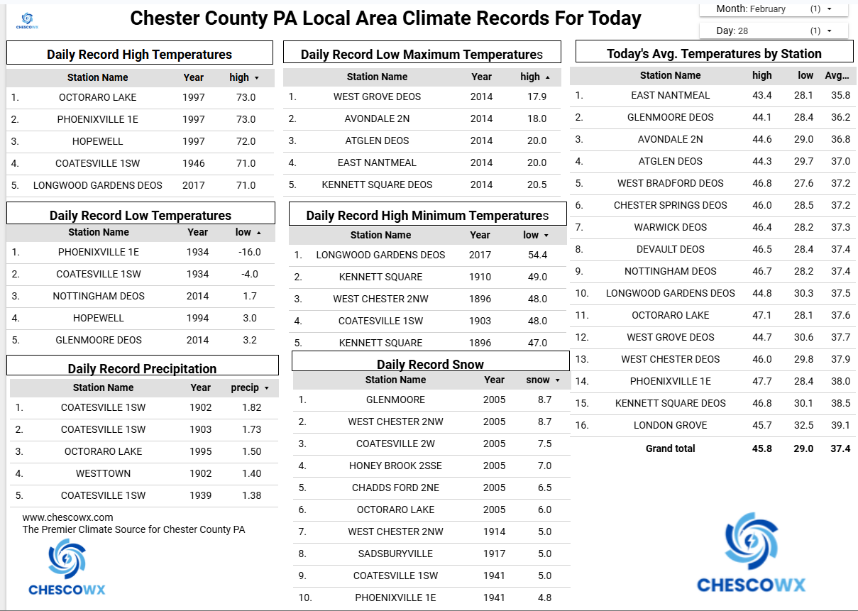
Feb EWR: 3.31 LE / EWR: 29.3 (snow)