All Activity
- Past hour
-
Was just about to post that.
-
The HRRR is an outlier with focusing on the period around dinner time. Multiple other CAMs say that the period of interest for a good part of the area is much earlier. I recommend looking at the experimental RRFS on Pivotal It really crushes the DC/PG/Howard crew fairly early.
-

July 2025 Discussion-OBS - seasonable summer variability
Jersey Andrew replied to wdrag's topic in New York City Metro
Thanks Don. I knew DC humidity was worse than anything I experienced growing up here in 1980s and 1990s. August will be a refreshing start but don’t know what second half will bring. -
RAH has really backed off rain chances for triangle north today. 80% to 40%. Really need a good soaking 2 weeks without rain with daily temps around 100 has turned it extremely dry in a hurry. Went from not watering the first 3 weeks of the month to barely able to keep the zoysia happy with daily watering
-
Yeah been saying this all July, I can’t remember this many days of 75+ dews. Normally that’s a high end type humidity day not every day of July.
-

E PA/NJ/DE Summer 2025 Obs/Discussion
LVblizzard replied to Hurricane Agnes's topic in Philadelphia Region
Bunch of storms popping up across central and eastern PA. A few hours earlier than modeled. Hopefully this keeps temperatures down today. -

July 2025 Discussion-OBS - seasonable summer variability
jm1220 replied to wdrag's topic in New York City Metro
NWS could’ve kept the heat advisory. JFK is 88/75/98 at 11am. Feels like a swamp outside. -

July 2025 Obs/Disco ... possible historic month for heat
dendrite replied to Typhoon Tip's topic in New England
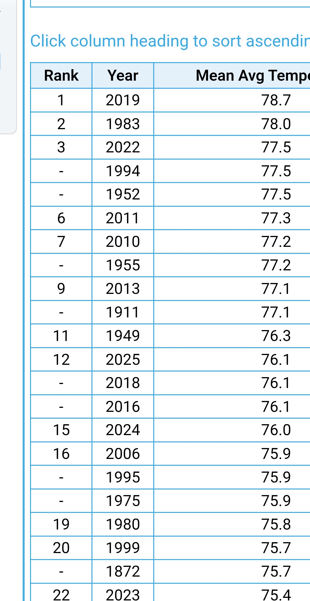
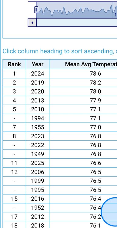
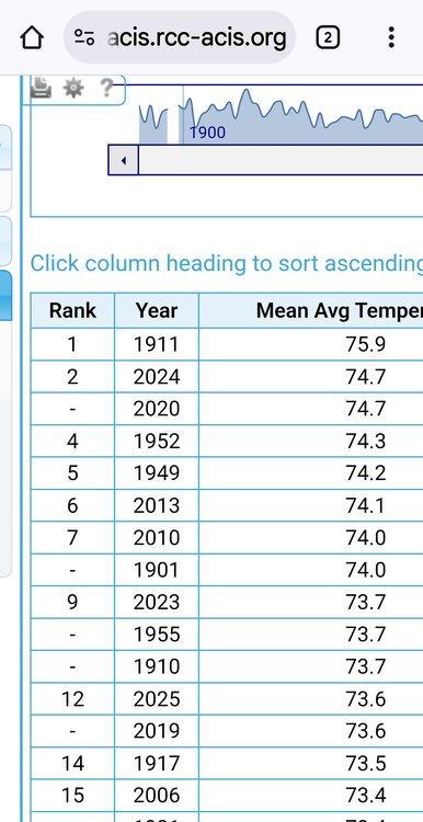
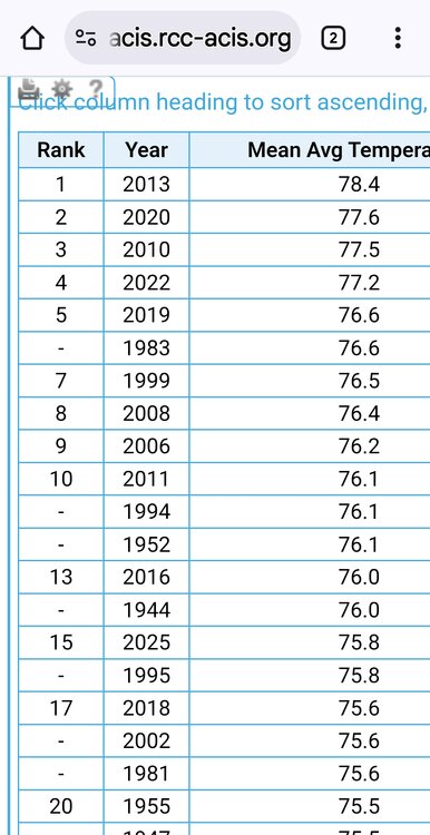
I already listed rankings. Thanks. ORH is 9 or 10 if you take out the low elevation site. -
TH ends at 7.53" for July. 8th wettest. The lack of stms last weekend, that was forecast to be robust, had potential to bring me up into the top 5, but that's ok, a good rain for the month really helped us back to near avg on the YTD 18.38" (17.94" avg). Max avg 73 (75.1)/ Min avg 57.4 (54.5). 7am time adj will bump up the min by about 0.5. Max will be about the same. Cooler max/warmer min. Hmmm, where have I heard that before. (OK OK just sayin lol)
-

July 2025 Discussion-OBS - seasonable summer variability
Brian5671 replied to wdrag's topic in New York City Metro
alot sunnier than expected...most places will overperform temp wise-also more fuel for storms later -

July 2025 Obs/Disco ... possible historic month for heat
weatherwiz replied to Typhoon Tip's topic in New England
Humidity needs to be factored in as well, especially considering how humid it has been this summer and how often we had oppressive dewpoints. Not dismissing the temperature data and what the rankings are but in terms of capturing the entire picture, humidity needs to be factored in to provide full context and perspective. -
July 2025 Discussion-OBS - seasonable summer variability
jm1220 replied to wdrag's topic in New York City Metro
Some 90s showing up in N Wantagh/Massapequa. -

July 2025 Obs/Disco ... possible historic month for heat
Ginx snewx replied to Typhoon Tip's topic in New England
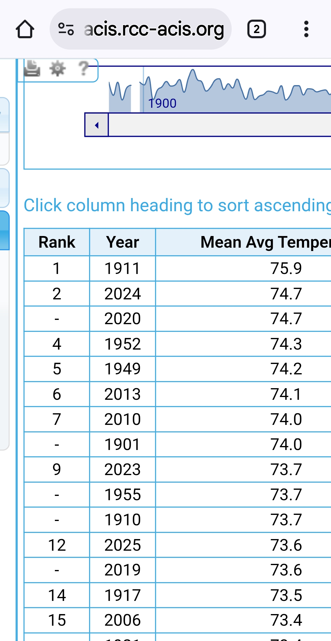
Average lows didn't crack top ten lowest in SNE except HFD area was number 9. Lots of hype -

July 2025 Obs/Disco ... possible historic month for heat
TauntonBlizzard2013 replied to Typhoon Tip's topic in New England
Another missed rain event today. It’s so dry -

July 2025 Discussion-OBS - seasonable summer variability
donsutherland1 replied to wdrag's topic in New York City Metro
Here's a gift link so that anyone can read the article: https://wapo.st/4mdOi2m -
Storms are already rapidly developing east of the river currently. https://weather.cod.edu/satrad/nexrad/?parms=CCX-N0B-1-24-100-usa-rad
-
This makes you wonder what it feels like when places have hit rare super high dew points of 88 or 90.
-

July 2025 Obs/Disco ... possible historic month for heat
Modfan2 replied to Typhoon Tip's topic in New England
Looking like a I-84 NW rain event so far -
Another note - a lot has been said about flooding/rainfall totals (rightly so) but Elliott is really hyping severe weather this afternoon. He said that CAPE is as high as it ever gets in these parts and he fears that storms will pack winds of 60-70 mph. That concerns me.
-
July 2025 Obs/Disco ... possible historic month for heat
Ginx snewx replied to Typhoon Tip's topic in New England
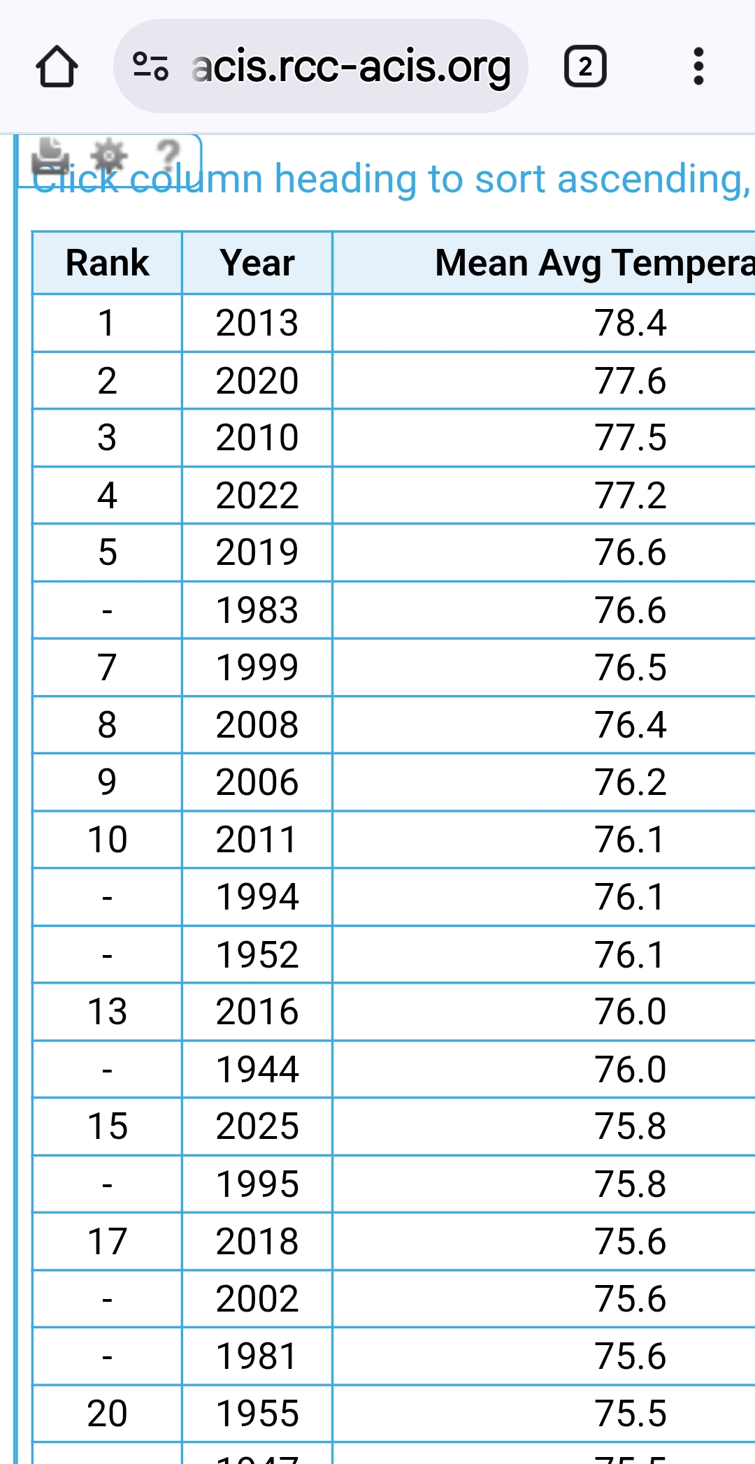
Boston, Hartford, PVD, ORH Not even top ten hottest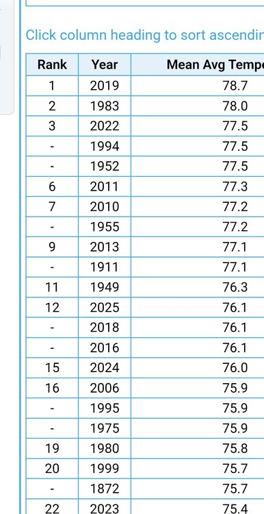
-
Haha, wunderground now has all of Cumberland county and Harrisburg city proper getting less than 0.10" of rain today Sent from my SM-G970U1 using Tapatalk
-
Saw my first baby furry caterpillar today, severe winter upcoming is a lock!!!
-
 Carteret put out a message that we could be in the bull’s-eye, could be 5 to 7 inches of rain, expect flooding, stay off the road, etc. I don’t want anyone to see that much water! At least they’re being more proactive than usual, because it’s damn near a guarantee we’re going to flood, it’s just a matter of how badly. I wish everyone good luck and safety.
 -
Stuffing popping up in northern Balt Co.
-

July 2025 Discussion-OBS - seasonable summer variability
SACRUS replied to wdrag's topic in New York City Metro
https://www.washingtonpost.com/weather/2025/07/31/record-humidity-july-maps/