All Activity
- Past hour
-
Most spots should finish warmer tha average but the cooler spots like LGA, BDR, amd NYC could finish a little below. EWR….+2.5 NYC…..+1.4 JFK……+1.8 LGA……+0.8 HPN……+2.9 ISP……..+3.3 BDR…..+0.4 New Haven….+3.8 New Brunswick…+2.3
-
Insane. Stalled at 42 and never went further.
-
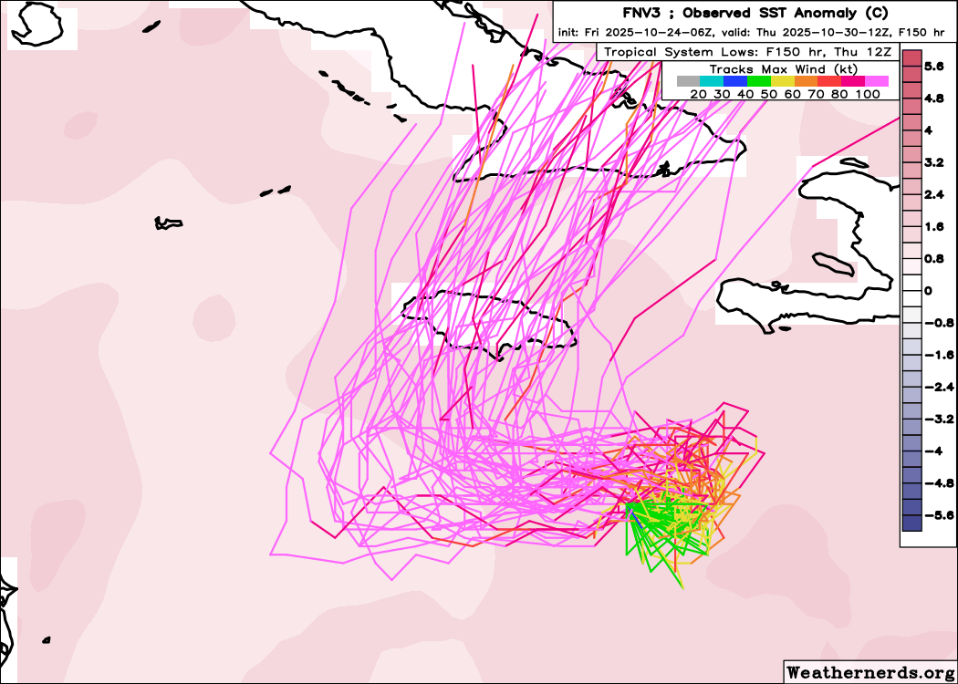
06z Google.... almost all tracks now over Jamaica.

-
Hi all, MD Climate Bulletin for September 2025 follows: "We are pleased to share the Maryland Climate Bulletin for September2025, which includes sea surface temperatures for the Chesapeake Bayand the state's coastal waters. However, due to the ongoing federalgovernment shutdown, the availability of the main data source we usefor the Bulletin has been affected. The regular production of thebulletin is only possible thanks to the hard work and data provided byour friends at NOAA National Centers for Environmental Information,the CoastWatch East Coast Node, the Institutions involved in the U.S.Drought Monitor, and the U.S. Geological Survey's Water Watch.You can access the Bulletin from the following link:https://mdsco.umd.edu/Bulletin/bulletin_mdsco_current.pdfPoints to highlight are:1) Statewide averages indicate that September 2025 was warmer anddrier than normal (i.e., 1991-2020 averages).2) Regionally, the mean temperature was warmer than normal over themajority of the state. Warmer-than-normal anomalies appeared over thenorthern half of the state, especially over parts of Carroll,Frederick, and Washington counties (around 1.0°F). Colder-than-normalconditions appeared over the southern counties to both sides of theBay, particularly over Charles County (around 1.0°F below).3) Precipitation was below normal for the majority of the state,notably over Frederick and Washington counties (2.0 to 3.0 inchesdeficit), and over Garrett, Allegany, Carroll, Montgomery, Howard,Baltimore, Harford, Cecil, Charles, and Prince George’s counties (1.0to 2.0 inches deficit). Above normal precipitation appeared over someareas in the Eastern Shore, over Queen Anne’s, Kent, and Worcestercounties (larger than 2 inches), as well as over portions ofDorchester and Wicomico counties (1.0 to 2.0 inches). The first ofthese regions, over the western states, received 25 to 50% lessprecipitation than normal, while the regions in the Eastern Shore got25 to 50% more precipitation than normal for the month.4) Drought conditions intensified in September, primarily in thewestern counties. While the extent of the state affected by droughtdiminished from 70% to 50%, Moderate Drought conditions affectedGarrett, Allegany, and Washington counties along the limits with WestVirginia, as well as western and central Montgomery County. SevereDrought conditions also developed over the western counties, and evenExtreme Drought conditions started to creep over the southern tip ofGarrett County. The rest of these counties were under Abnormally Dryconditions, which also affected Frederick, Carroll, Baltimore, Howard,Prince George’s, Charles, Calvert, Saint Mary’s, and Caroline. Severalstreams and rivers in the Piedmont and western Maryland hadBelow-normal streamflow, with a few experiencing Much-below-normalstreamflow.5) The Chesapeake Bay sea surface temperatures (SST) in September 2025ranged between 73 and 78°F, marking the second consecutive month theyremained below their 2007–2020 mean across the entire region. Adistinct north-to-south gradient defined the magnitude of the coldanomalies. The most significant deficit (3–4°F below average) wasrecorded in the southeastern Lower Bay, encompassing Tangier Soundwaters off Somerset, Wicomico, and Dorchester counties. Movingnorthward, along the coasts of Talbot and Queen Ann counties up toEastern Bay, the anomalies lessened to 2–3°F below the mean. Thewaters off Kent and Baltimore counties and farther northward in theUpper Bay, showed the smallest cold anomalies (1–2°F below).Chincoteague Bay temperatures were also notably colder than normal(2–3°F below). The all-basin mean temperature of 74.0°F was stillwarmer than the coldest September in the 19-year dataset (2007-2025),which recorded 72.8°F in 2009.Please refer to the bulletin for more details. The bulletin is issuedonce per month and shows the state's recent monthly surfacetemperature and precipitation conditions in a simple format, helpingMarylanders better understand regional climate variations.Please help disseminate this bulletin.Thanks,Alfredo.............................................Alfredo Ruiz-Barradas, PhDAssociate Research ProfessorMaryland State Climatologist"
-
No. The long-duration block should provide just enough cool weather to result in a modest cool anomaly for October.
-

Spooky Season (October Disco Thread)
CT Valley Snowman replied to Prismshine Productions's topic in New England
Down to 33 this morning with areas of frost. -
33.5. More light frost. Ready for the first freeze. Maybe in about 7-10 days.
-
30 at MSP. First official freeze at the airport.
-
Interesting comparison of positive/negative AMO winters with this ENSO state. For sensible outcomes, the -AMO list is snowier for us I think than the +AMO outside the 95-96 fluke.
-
Low 35
-
are we still forecasted to have an above normal october?
-

Spooky Season (October Disco Thread)
amarshall replied to Prismshine Productions's topic in New England
110 % oaks still left south shore. -

Spooky Season (October Disco Thread)
SJonesWX replied to Prismshine Productions's topic in New England
I’m with Dendy. most maples and birches are bare, oaks browning but still have ~90% of their leaves. It’s ok, they will all fall down right after I do leaf cleanup tomorrow -
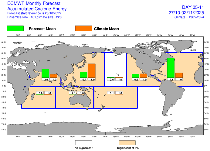
IF the NHC forecast were to play out, Melissa could end up having the 3rd highest ACE on record for so late in the season of the last 100 years behind only Mitch of 1998 and the Nov Cuba H of 1932! Wilma wouldn’t qualify because it dissipated too early (10/25). Going back further to 1851 on the record, only storm #6 of 1896 would appear to quite possibly have higher ACE later than Melissa again assuming NHC forecasts verify. So, Melissa could very well end up in rare company regarding the lateness of a very large ACE for a single storm on record. ———— Edit: This from yesterday’s Euro Weeklies illustrates well how high the ACE potential is: this shows 4.1 the normal ACE or ~15, which is near the normal for the peak week climo centered around Sept. 11th! That is almost entirely from Melissa. But that is only for Mon (10/27) through Sun (11/2). So, that doesn’t even include today through Sun.
-

Central PA Fall Discussions and Obs
Superstorm replied to ChescoWx's topic in Upstate New York/Pennsylvania
Much respect. This is the way it needs to be done! -

Central PA Fall Discussions and Obs
canderson replied to ChescoWx's topic in Upstate New York/Pennsylvania
36 here too. -
46 this morning
-

Central PA Fall Discussions and Obs
Mount Joy Snowman replied to ChescoWx's topic in Upstate New York/Pennsylvania
Low of 36. Brought the big palm tree into the house for the season yesterday, guy's been with us for a few years now, doing well. The seasons, they are a changin'. -

Central PA Fall Discussions and Obs
mahantango#1 replied to ChescoWx's topic in Upstate New York/Pennsylvania
Your old school for sure. -
34 for the low here
-
It’s way too early to pop any champagne but it looks promising at least.
-
Only got down to 45.5 here
- Today
-
36.6 this morning.
-

Central PA Fall Discussions and Obs
Itstrainingtime replied to ChescoWx's topic in Upstate New York/Pennsylvania
Coldest temp of the season this morning here in Maytown, checking in at 33.4 degrees First frost of the season here at my house, and it was a doozy. Solid blanket of white. Interestingly, I saw no other frost outside of Maytown on my way to work. It's been the exact opposite several times over the past few weeks. Had to scrape my car windows before leaving for work. No, I do not start my car and go back in the house. I like to be out and scrape. (with the engine defrosting) -
Central PA Fall Discussions and Obs
Itstrainingtime replied to ChescoWx's topic in Upstate New York/Pennsylvania
Yeah, that's unacceptable. It was a comfortable 61 in our house this morning.