All Activity
- Past hour
-
Like Oprah says “speak it into existence”.
-
Yeah thanks for the tip, I think I'm gonna end up out to the east in the Concord area, a little bit cheaper, and not in the city, and short commute heading away from the sun.
-
4.0” here.
-

December 14th - Snow showers or Plowable snow?
FlashFreeze replied to Sey-Mour Snow's topic in New England
He is a little down the road from me -
The normal 8” snowfall with no warning lol. Everyone out here caught off guard
-
Euro has a snowstorm Christmas night
-
Plus the indicator benchmark actually has worked better for 3” (15 out of 15) than for 4” (14 out of 15). Considering what you said (although I think the indicator has value if used correctly…this storm should more than be enough) and that 3” actually has worked better, I feel that this should already be more than enough (and we still have half the month to go, besides) to consider this a bullish indicator for NYC’s coming Jan+ snowfall to be in the vicinity of or above the 30 year normal of 24” for Jan+. Thus, I’m now predicting NYC will have at the very least 21” from Jan onward on top of whatever the Dec total ends up at: Season…Dec NYC SN...Jan+ NYC SN 20-21…..10.5”….28.1” 17-18……7.7”……33.2” 16-17……3.2”……27.0” 10-11…..20.1”…..41.8” 08-09…..6.0”…..21.6” 05-06…..9.7”…..30.3” 00-01…..13.4”…..21.6” 95-96…..11.5”……64.1” @bluewave@donsutherland1
-

Pittsburgh/Western PA WINTER ‘25/‘26
Gordo74 replied to Burghblizz's topic in Upstate New York/Pennsylvania
Ended up at 8.25" after 3 rounds of lake effect this morning. Now the cold really setting in. Feels a ton like winter. Couldn't be happier. -
Picked up 1.5” from the lake. Still getting occasional snow showers but it’s compacting faster than it can accumulate. 4” snow depth. Savoring it before the torch.
-

December 14th - Snow showers or Plowable snow?
WxWatcher007 replied to Sey-Mour Snow's topic in New England
Congrats to everyone that got on the board. -

December 14th - Snow showers or Plowable snow?
dryslot replied to Sey-Mour Snow's topic in New England
I think you're in a great spot for this. -

December 14th - Snow showers or Plowable snow?
Damage In Tolland replied to Sey-Mour Snow's topic in New England
2.8” as it winds down -

December 14th - Snow showers or Plowable snow?
DavisStraight replied to Sey-Mour Snow's topic in New England
Looks centered in the greater Portland area but nice and steady here. -
Agreed - take a look at the 12Z GFS - cold shot after cold shot after the milder period later this week and signals of another snowstorm brewing the last week of December
-

Central PA Winter 25/26 Discussion and Obs
Jns2183 replied to MAG5035's topic in Upstate New York/Pennsylvania
Miler b always increase risk of heartache in this area Sent from my SM-X210 using Tapatalk -
We just had a legit wicked snow squall roll through. I couldn’t see more than 150ft ahead of me at one point. A quick .7”. Taken right before all hell broke loose.
-
The 12z GEFS shows an interesting evolution of the Scandinavian ridge. Its retrogrades west quickly, establishing a strong -NAO, which then pumps the cold air over Quebec down the east coast while our death ridge gets beaten into oblivion. Despite that, there’s enough of a gradient that one has to think it would open the opportunity for either a miller b or an overrunning setup that would favor the upper southeast and yes, east of the apps for once.
-
December 14th - Snow showers or Plowable snow?
dryslot replied to Sey-Mour Snow's topic in New England
I had written it off actually, A couple models showed some snow getting up here but not enough for me to get onboard. -
Roughly 7.3” here, highest amount was 8” even, lowest was 6” even. Still some very light snow but it’s much brighter now with the sun starting to peak through.
-

Mid to long range discussion- 2025
WinstonSalemArlington replied to wncsnow's topic in Southeastern States
Just for the record, for today’s I-95 corridor event, the Euro AI was supreme to just about everything from nearly 6 days out -

December 14th - Snow showers or Plowable snow?
TauntonBlizzard2013 replied to Sey-Mour Snow's topic in New England
Amazing how you crapped on this event for days and you’ll end up with more than me lol. Classic -
Got approximately 6.5" here in Brick.
-

December 14th - Snow showers or Plowable snow?
CoastalWx replied to Sey-Mour Snow's topic in New England
Cape is gonna look awesome tomorrow with all this wet snow. -
December 14th - Snow showers or Plowable snow?
CoastalWx replied to Sey-Mour Snow's topic in New England
Let’s snake that to Weymouth -

December 14th - Snow showers or Plowable snow?
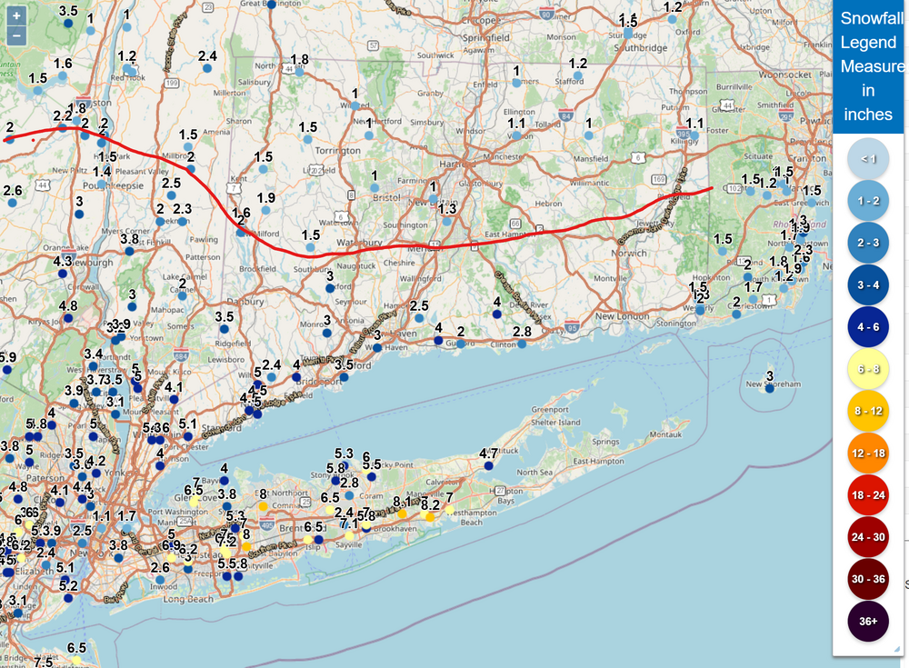
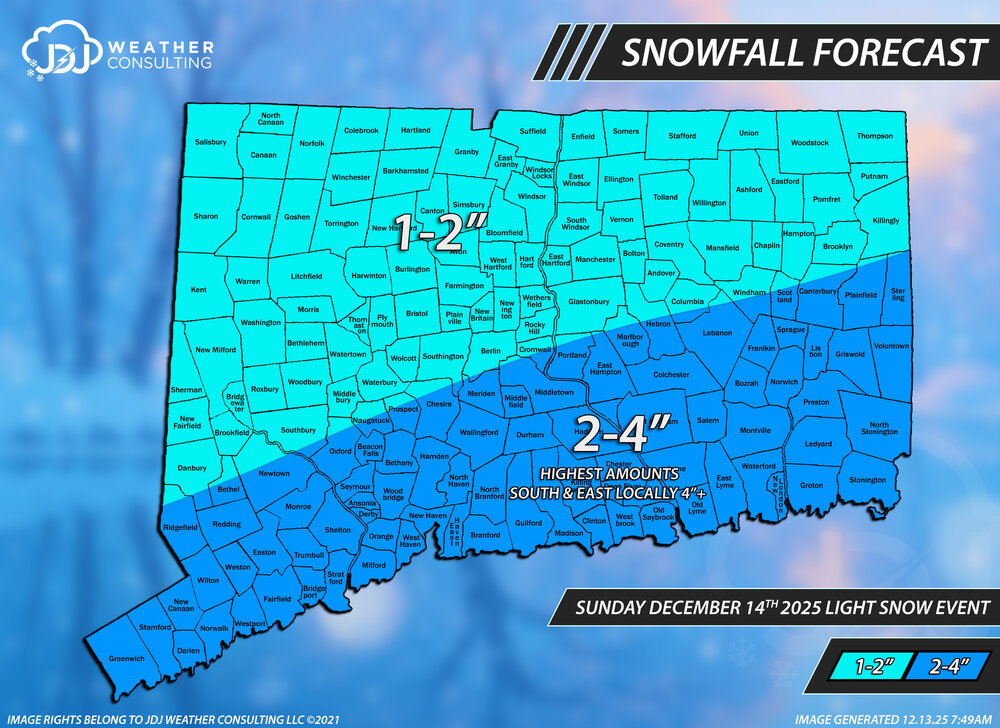
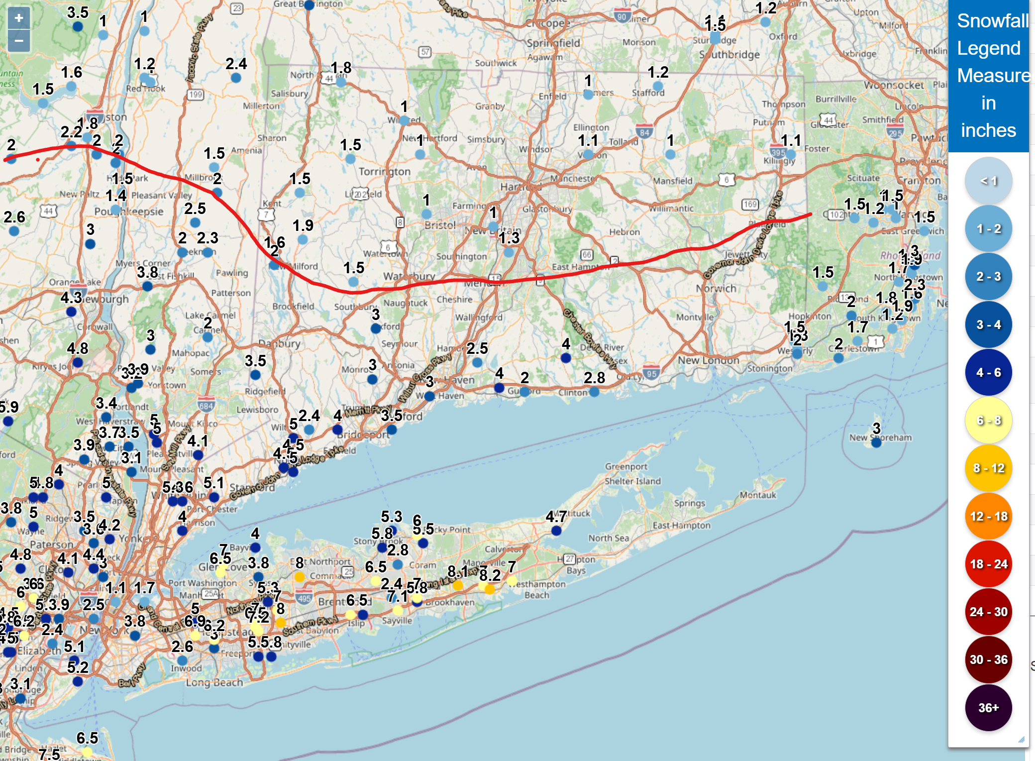
The 4 Seasons replied to Sey-Mour Snow's topic in New England
Most of the southern 4 counties of CT will be falling in the 2-4" range and 1-2 north of there. Keep in mind a lot of these reports aren't final so theyll be higher than this. this approximates the 2-5" line in CT. ill know tommorrow morning after i get cocorahs reports, coop and NWS PNS releases. Where i drew the line is pretty close to actuality but just tilted a bit more flat and then goes up through nrn fairfield cty.