All Activity
- Past hour
-

Possible Record Breaking Cold + Snow 1/25 - 1/26
wthrmn654 replied to TriPol's topic in New York City Metro
It clearly well miss, missing us -

Possible Record Breaking Cold + Snow 1/25 - 1/26
eduggs replied to TriPol's topic in New York City Metro
Get the arc of significant overrunning to OH and PA inside 84 hours on the CMC, AIGFS, and EPS-AI, and I'll be a believer in a big event. Until then I'm on guard for wave interference and a non-ejecting ULL. -
You're not a deb, you're raising several legitimate issues. As others have said, this event has ingredients incorporated that other storms have not had: favorable MJO phase, southern stream energy, strong boundary. Caution is certainly advised, but this is the best snow setup we've had in years.
-

January 2026 regional war/obs/disco thread
Snowcrazed71 replied to Baroclinic Zone's topic in New England
Wait a minute, maybe he's the Pope!!!?? Lol -

January 25-26 Winter Storm Potential
PhiEaglesfan712 replied to Ralph Wiggum's topic in Philadelphia Region
-
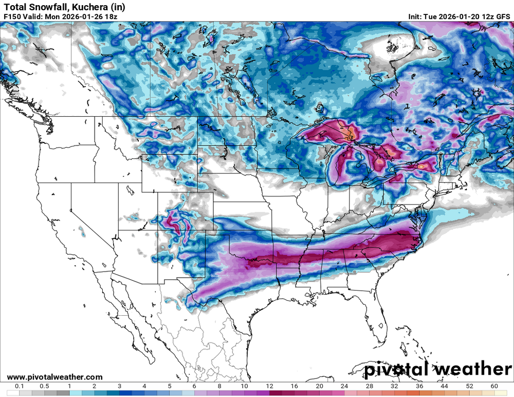
The UKIE did run on Pivotal but somehow crashed off after I'd seen it already. 12+ over the midstate. The pivotal map may include sleet on the 10:1, not sure.
-
Being in the foothills is so fun. I’ll literally take anything at this point. But, we’re so close to historic territory. We need the Baja low to beef up the precipitation but not too much interaction because it leads to mixed precipitation. But, if we tend weaker, we lose the precipitation and the cutoff becomes too close for comfort
-
You’re not wrong, but I have a hunch the cold air is overdone. The better gfs runs show ~1040 high instead of near 1050. Chicken egg thing…is that causing the Baja low to spin itself out or is the low shearing out allowing the hp to overwhelm. I’ll let you know next Monday.
-
Damn, you're worse than me. I get annoyed when the GFS is on board, but I ain't crashing out about it. *but yeah, the GEFS does make me feel better. Shhh
-
Completely understand but at some point dry streaks end. Perhaps this is it
-
This is not a northern stream event so no. If it kicks out that energy it’s game on.
-
We haven't had the MJO shift to Niño phases until now.
-
The trend today has been to slow the timing down. Friday night start time here has turned into Saturday afternoon on most modeling
-

Appreciating Each Other/Poster Compliments
RodneyS replied to SnowenOutThere's topic in Mid Atlantic
And I also agree with @PrinceFrederickWxabout @Roger Smith, who has put more effort into running contests and compiling statistics than anyone I know. -
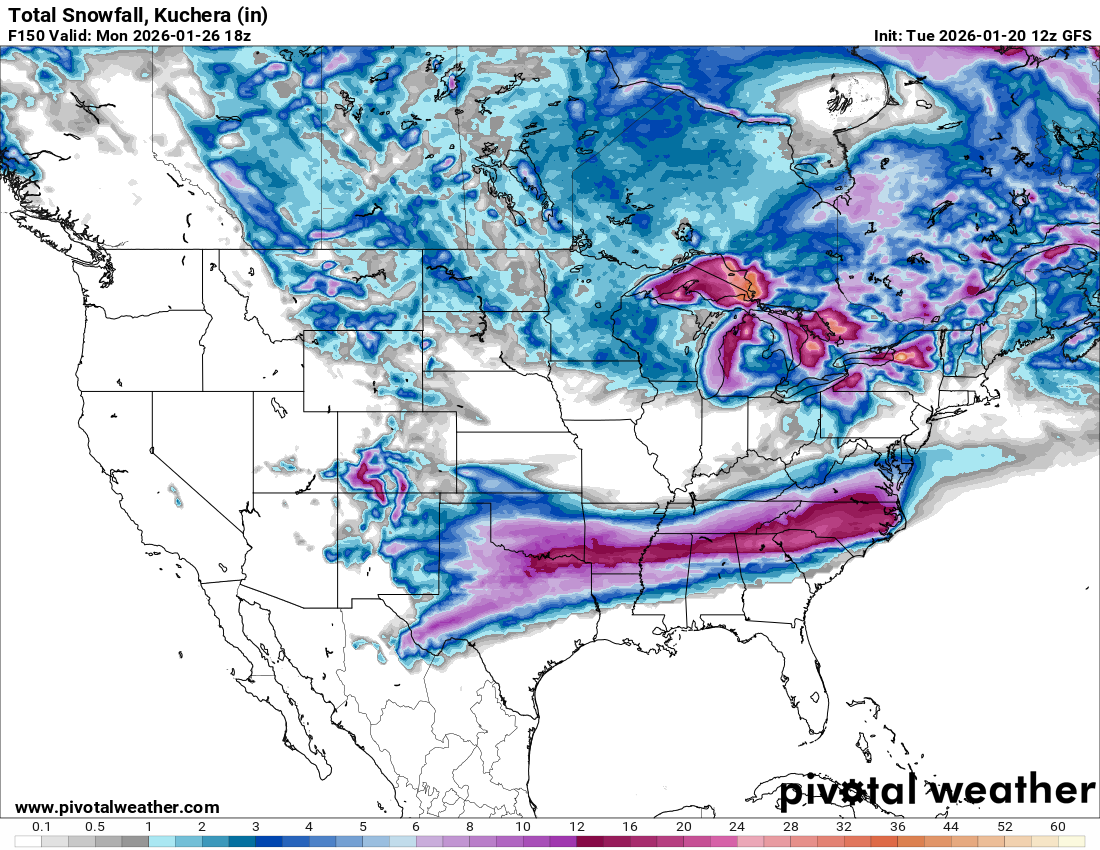
This map from Pivotal must include sleet and ice unlike the WxBell maps. It's significantly higher, and probably more realistic given the likelihood of significant sleet accums on the southern end of the snow band.
-

January 25-26 Winter Storm Potential
Mikeymac5306 replied to Ralph Wiggum's topic in Philadelphia Region
So it's basically GFS vs the world again? Got it. -

Pittsburgh/Western PA WINTER ‘25/‘26
colonel717 replied to Burghblizz's topic in Upstate New York/Pennsylvania
I agree if something like the ICON is the end result, more than satisfied. -

Possible Record Breaking Cold + Snow 1/25 - 1/26
jm1220 replied to TriPol's topic in New York City Metro
If I see “it’s going to miss” or “it won’t snow up here” type posts I’m just deleting them. Grow up, take it to banter or better yet just don’t post. It’s a storm 4-5 days away and there will be changes based on a complex evolution. -
I remember Dec 2019 brought around 19” IMBY and then Feb 6 2010 dropped 25”. The latter storm felt much bigger and more of a beast. Not to downplay the December storm but Feb 2010 (even the first storm) was just a different league.
-
Possible Record Breaking Cold + Snow 1/25 - 1/26
eduggs replied to TriPol's topic in New York City Metro
Good signs: - Relatively stable solutions run-to-run on the UKMET and CMC. - 12z ICON adjusted towards the ECM/UK/CMC solution - Storm evolution has trended towards a longer duration event in recent cycles - EPS, EPS-ICON, GEPS have trended north with QPF in recent cycles Not great signs: - The AIGFS has moved away from a big storm idea over the past few days - 12z GFS reversed a multi-cycle positive trend with a sudden shift towards wave-interference - EPS, GEPS still relatively dry (though that's typical considering ensemble spread at this lead time) -
I can't remember a storm here in HKY where we were in the upper teens with zr my suspicion would be mostly IP over ZR, but again depends on where you are.
-
Euro run will be fascinating.
-
26 years to the day of Jan 25, 2000 Ninja'd by double d
-
12ZGFS was SOLID. Now's the time we want to see it creep south a bit. And the duration of this storm is just incredible! Canadian to a jog south too.
-

2025-2026 New England Snow Recordkeeping Thread
SouthCoastMA replied to bristolri_wx's topic in New England
@The 4 Seasons17.5" - Sandwich, MA ESandwich Coop might have slightly more