All Activity
- Past hour
-
The Euro will catch on as soon as we get Jebman on board.
-

Jan 24-26 Weekend Snow and Sleetfest Model Thread Part Tres
bncho replied to H2O's topic in Mid Atlantic
Quick question--was the Jan 6 2025 event progged to jack DC/Baltimore and places north 3 days out before slowly correcting and eventually jacking Fredericksburg? or am I imagining? -

January 25-26 Winter Storm Potential
Ralph Wiggum replied to Ralph Wiggum's topic in Philadelphia Region
But 20 years ago this setup would never have pushed the mix line that far N and W as this one. And I understand this is more 700-800 mb layer stuff, but still. Yes, climo always N and W i agree. But when did i78 become the line? This is 4th or 5th time since 2018. -

Possible Record Breaking Cold + Snow Sunday 1/25 - Tuesday 1/27
lee59 replied to TriPol's topic in New York City Metro
They actually just changed it to 8-12 on Sunday and 1-3 on Sunday night. -
In the timbers of FennarioThe wolves are runnin' 'roundThe winter was so hard and coldFroze ten feet 'neath the ground
-

Jan 24-26 Weekend Snow and Sleetfest Model Thread Part Tres
Solution Man replied to H2O's topic in Mid Atlantic
What about NOVA -

Possible Record Breaking Cold + Snow Sunday 1/25 - Tuesday 1/27
MJO812 replied to TriPol's topic in New York City Metro
Nice 10-14 inches Lets go ! -

Possible Record Breaking Cold + Snow Sunday 1/25 - Tuesday 1/27
TriPol replied to TriPol's topic in New York City Metro
*clears throat* It's time for the obligatory... It's nowcasting time. -

January 25-26 Winter Storm Potential
The Iceman replied to Ralph Wiggum's topic in Philadelphia Region
I think the 2000's/early 2010's really shifted perspectives to how climo actually is in this region... Philadelphia itself has only gotten a 10" or more snowstorm 31 times since 1883. Averages out to like 1 every 5 years. It really isn't a common occurrence. -
-

Jan 24-26 Weekend Snow and Sleetfest Model Thread Part Tres
balltermen replied to H2O's topic in Mid Atlantic
It's not good. Especially at this range. I would maybe use it closer in, in conjunction with other models. But weigh it very little and toss if an outlier. -
Just got back from Portsmouth and Dover. It's a madhouse out there with all the pre-storm bread and milk gathering going on
-

Pittsburgh/Western PA WINTER ‘25/‘26
colonel717 replied to Burghblizz's topic in Upstate New York/Pennsylvania
This looks much better http://www.meteor.iastate.edu/~ckarsten/bufkit/image_loader.phtml?site=kpit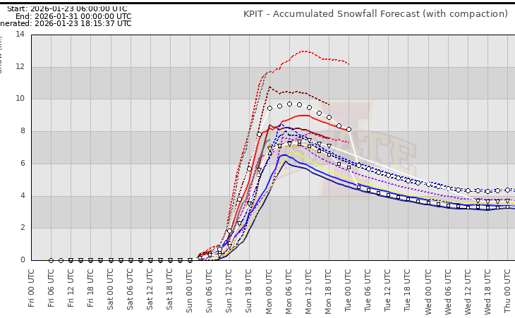
-

MO/KS/AR/OK 2025-2026 Winter Discussion
MoWeatherguy replied to stormdragonwx's topic in Central/Western States
Crazy stuff. Maybe this is gonna be a wallop this time. -

“Cory’s in LA! Let’s MECS!” Jan. 24-26 Disco
Cyclone-68 replied to TheSnowman's topic in New England
You know you’re doing well when you can assume at least a foot before it starts lol -

Jan 24-26 Weekend Snow and Sleetfest Model Thread Part Tres
WEATHER53 replied to H2O's topic in Mid Atlantic
It’s been my contention all week that a flat and fresh very cold 1035 high in a great position just does not get bullied and give it up -
Funny you sent this. I’m headed there in like 15 min to pick up some of my buddy’s favorites.
-
That's why I wasn't hating on the suppressed looks early in the week. My weenie eyes have seen this movie too many times.
-

Pittsburgh/Western PA WINTER ‘25/‘26
MikeB_01 replied to Burghblizz's topic in Upstate New York/Pennsylvania
Sorry about the bad quality. But thought this was pretty insightful . -
Bigger problem for North Georgia. In spring (when I wanna chase) it curls around and stabilizes everything. In winter the warm nose usually wins. Hey @jaxjagmanwe do have Day 3 Marginal in South Bama and text mentions tornadoes!
-
JMA gives the Triangle to the NW 1.5-1.8" qpf it's quiet in here
-

Pittsburgh/Western PA WINTER ‘25/‘26
Rd9108 replied to Burghblizz's topic in Upstate New York/Pennsylvania
Met from other forum Trends overall today were for a slightly weaker primary which is good. We don't want it too weak for our area though or we will lose the precip max in SW PA showing up on some models. -
What’s the sleet/ice potential like for Austin? It seems like we avoid the worst of the effects overall but could still see some ice/sleet?
-

Mid-Long Range Discussion 2026
WinstonSalemArlington replied to BooneWX's topic in Southeastern States
That’s good news for now. Suppressed -
Day 2 Convective Outlook NWS Storm Prediction Center Norman OK 1059 AM CST Fri Jan 23 2026 Valid 241200Z - 251200Z ...NO SEVERE THUNDERSTORM AREAS FORECAST... ...SUMMARY... The risk for severe thunderstorms appears negligible across the U.S. Saturday through Saturday night. ...Discussion... Downstream of amplified split flow across the Pacific into western North America, it still appears that several short wave troughs will gradually consolidate into larger-scale mid-level troughing across the Rockies and Great Plains into Mississippi Valley through this period. This is likely to include at least a couple of merging perturbations of Canadian Arctic origin digging across the international border through the northern U.S. Rockies and Great Plains, and another emerging from the northern mid-latitude Pacific before digging inland across the Pacific Northwest coast through the southern Great Basin. Yet another impulse, emerging from the southern mid-latitude eastern Pacific, and currently in the form of a mid-level low as it digs toward Baja, is forecast to undergo considerable deformation while being forced eastward, then northeastward, across the northern Mexican Plateau into the southern Great Plains by late Saturday night. This is being preceded by the southeastward development of an expansive cold surface ridge across much of the nation to the east of the Rockies, as far south as the Gulf coast vicinity. While highest surface pressures centered across the Upper Midwest, Ohio Valley and Great Lakes at the outset of the period are forecast to continue to fall while shifting northeastward, it appears that the residual Arctic air mass will impede significant inland surface cyclogenesis. Models do still indicate modest deepening of surface troughing in one corridor across the lower Mississippi Valley toward the lower Ohio Valley (as well as in another near/offshore of the Carolina coast) by late Saturday through Saturday night. Elevated moisture return above the cold air to the north and northwest of this feature appears likely to be accompanied by weak destabilization. However, appreciable boundary-layer destabilization along the surface trough axis, inland across southeastern Louisiana through southeastern/east central Mississippi and adjacent western Alabama by 12Z Sunday, appears unlikely. This is expected to minimize the risk for severe weather. ...Southern Great Plains/Lower Mississippi Valley... Convection allowing output and other guidance suggest that the most substantive potential for thunderstorm development will largely focus just to the cool side of the surface frontal zone, near/inland of mid/upper Texas Gulf coastal areas through Louisiana and central/southwestern Mississippi Saturday through Saturday night.. Layers of developing weak conditional and convective instability further aloft, and to the west through north, might become supportive of convective development capable of producing lightning, anywhere from the Texas South Plains and Big Country into the Mid South. The extent of this potential remains a bit unclear due to spread evident in the model output. However, further adjustments to the 10 percent thunder line may be needed in subsequent outlooks for this period. ..Kerr.. 01/23/2026