All Activity
- Past hour
-
.thumb.png.4150b06c63a21f61052e47a612bf1818.png)
First Winter Storm to kickoff 2025-26 Winter season
HIPPYVALLEY replied to Baroclinic Zone's topic in New England
Sane and realistic. -

Central PA Fall Discussions and Obs
Blizzard of 93 replied to ChescoWx's topic in Upstate New York/Pennsylvania
I’d sign for that to get on the official board for the season. -

First Winter Storm to kickoff 2025-26 Winter season
ORH_wxman replied to Baroclinic Zone's topic in New England
I’m hedging on the lower end here at the moment. I’m not convinced of some of these rates but we’ll see. If we can get a temporary bombing low scenario which isn’t impossible for a few hours, then we might be able to rip if we stay on the cold side. Id feel a lot better on winter hill, lol -

Central PA Fall Discussions and Obs
canderson replied to ChescoWx's topic in Upstate New York/Pennsylvania
Ego batteries charged up. Going with 2.5” for MDT. -
below freezing and above freezing, almost like 31.8f vs 32.3f
-
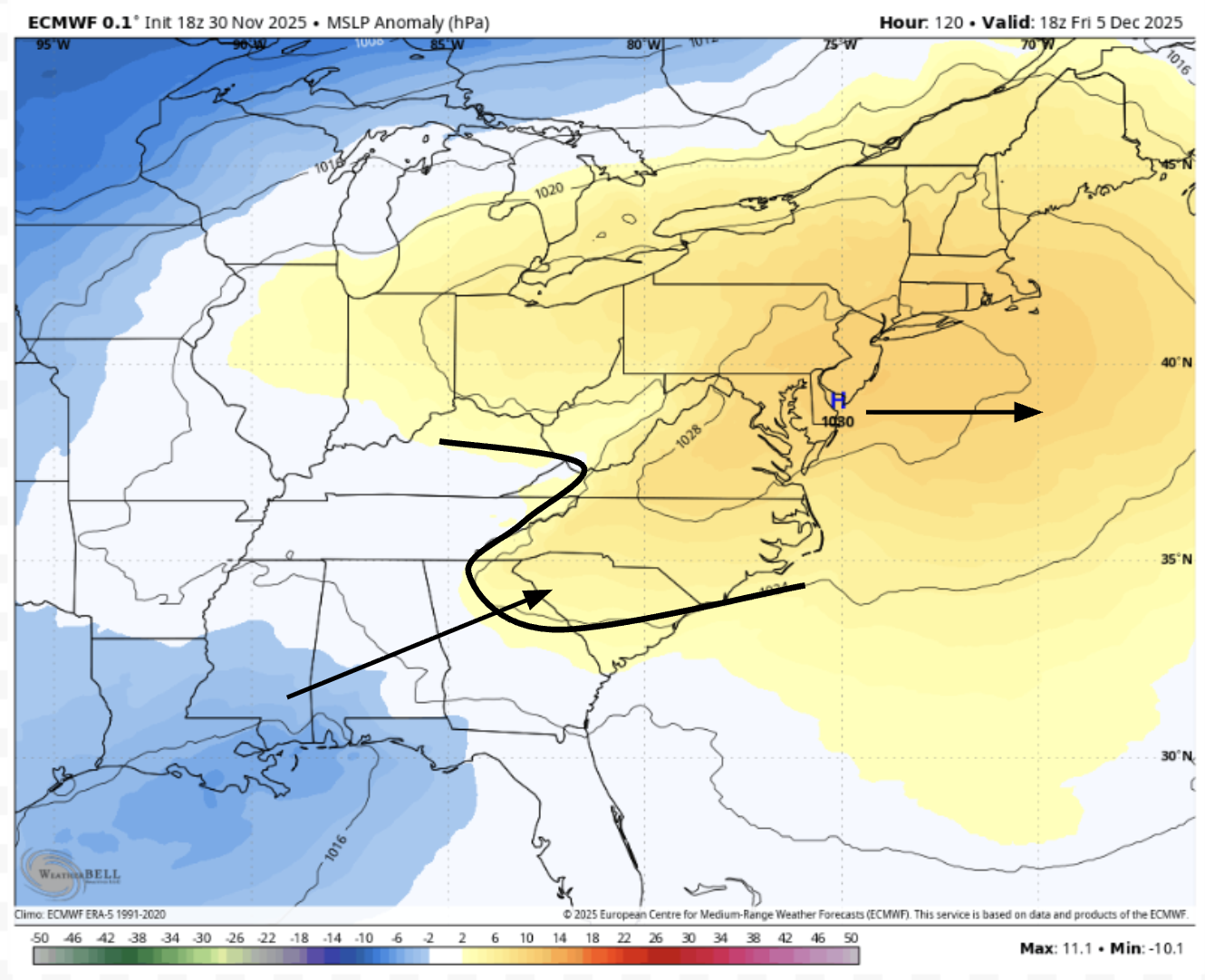
There are some things to like about Dec 5-6 and there are some things not to like about Dec 5-6. The -NAO certainly helps that cold high-pressure in that location, which will promote CAD. However, as modeled, the high is weak, isn't in a great spot, and will retreat east. Therefore, we lose the CAD, hence the flip from snow/ice to ice/rain. Perhaps this will trend colder as models start to take MJO 8 into consideration. It's probably a better overall setup and we've got more things going for this than Dec 2, and there's a decent signal on the EPS. We shall wait and see.

-
Still looking good locally for 2-4”. Hopefully someone cashes in on some fgen magic. These smaller events are fun in their own way.
-
First Winter Storm to kickoff 2025-26 Winter season
ORH_wxman replied to Baroclinic Zone's topic in New England
These early runs have a been a little flaccid on dynamics. But some of these mesos were also pretty bonkers to begin with. The massive 1-1.5 QPf getting well inland never looked that realistic. -
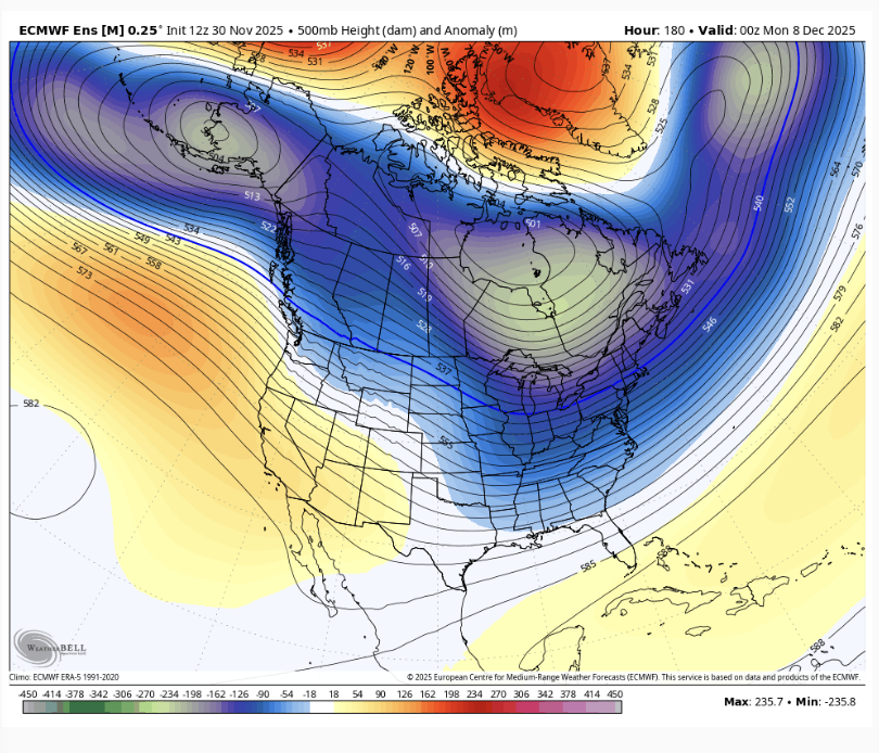
Canadian update continues to insist on El Nino conditions developing in February at the surface. Likely by January below the surface. Fairly cold winter nationally. Has the cold look for the North-Central US I've been getting from analogs since Aug/Sept. My blend from Oct - (2013 x4, 2024 x4, 2018, 2022). Hasn't broken yet. I am expecting a pretty widespread warm up after a cold first 10 days or so - we'll see if that pans out.
-
What’s the difference between a purple zero and a white zero?
-

First Winter Storm to kickoff 2025-26 Winter season
moneypitmike replied to Baroclinic Zone's topic in New England
Looks like qpf is getting reduced on the NAM (no suprise) and ICON. At least in Maine. Alas. -

12/3 Snow/Sleet/Mix Bag of Everything Discussion/OBS
LVblizzard replied to Mikeymac5306's topic in Philadelphia Region
Ahhh the classic snow to rain event in Allentown while the Poconos get hammered. I’m just glad we’re getting something this early in the season. -
This is bothering me a lot, as the NAMs are usually the colder solutions. I think we're still in the range where the NAM could be having synoptic issues, but if it continues on Monday to keep the accumulations further northwest of the I-95 corridor, I'm going to guess it's right. The faster onset, shown by the GFS and its hi-res HiResW FV3, would help a ton here, although even where it shows snow, the thermal profile has pretty much zero margin for error.
-
High of 52 after a morning low of 34. Was quite raw this afternoon, picked up .24” of rain and temps dropped to mid 40s
-
 TEMP _________DCA _ NYC _ BOS __ ORD _ ATL _ IAH __ DEN _ PHX _ SEA -4.0 -3.8 -4.5 -5.9 -3.3 -1.5 -3.6 -2.9 -2.4 SNOW _______ DCA _ NYC _ BOS ___ ORD ____DTW ___ BUF __ DEN _ SEA _ BTV 12.8" 25.6" 50.7" 57.3" 61.5" 115.7" 70.0" 12.5" 88.8"
 -

December 2025 regional war/obs/disco thread
Snowcrazed71 replied to Torch Tiger's topic in New England
It's not worth your time for some of these guys.... Their here every year pulling the same crap. It's comical. -
looks like a -AO/NAO to me
-

First Winter Storm to kickoff 2025-26 Winter season
powderfreak replied to Baroclinic Zone's topic in New England
Your area is probably the most interesting of anyone on the forum. That southern Middlesex County zone has been consistently modeled as the battle ground on all guidance. Like could certainly be 8-12" of paste, or like 2-4" of 4:1 slop. -
High not running off coast as fast
-
This is a better setup IF the EPS is right. Just a tad too far north and east
-
This thread should actually be extended to December 2nd (Tuesday) since it would last through at least that said morning. Not much on the 12z Euro: A bit juicy on the 00z NAM: So-so on the 18z GFS:
-
Thursday night looks very cold. Teens for many.
-

First Winter Storm to kickoff 2025-26 Winter season
Ginx snewx replied to Baroclinic Zone's topic in New England
True -

First Winter Storm to kickoff 2025-26 Winter season
CoastalWx replied to Baroclinic Zone's topic in New England
Can we get a Euro track with Nam dynamics? lol. -
Adding to the list!! Thanks Mappy