All Activity
- Past hour
-
OK.. So for all facing a potential ice storm - I'm sure you have prepared but if you have not: a few things to consider. 1) It is going to be BRUTALLY cold following the conclusion of this storm. If you do not have heat, your house will become cold, and quickly. Make sure you have plenty of layers. If you have a wooden fireplace, be stocked. If you have gas, even without electricity, you can use gas for some things. Sometimes an oven can turn on as well, depending on type. 2) Downed power lines must be treated as live at all times. Even if all power is out, an improperly installed generator can back feed the grid and when it hits a transformer, it can be stepped up to relatively high voltages. 3) Refrigerated foods can last to around 36 hours once the power is out and the refrigerator is not opened much. HOWEVER, if you can put ice in the refrigerator, the air tight seal combined with adding ice will help keep the refrigerator cold. Of course store ice is best, but if you can get some sleet, or even some chips of ice, it can help. Make sure food is covered and outside bins washed off before using or cooking to ensure against contamination. Also use judgement about where you take ice/snow/sleet from. But last resorts are last resorts 4) IF we obtain a crippling amount of ice then expect impacts to linger for weeks, including potential loss of power, diminished or absent emergency services and impassable roads. 5) If you have no heat whatsoever, you can use a vehicle to sit in. Some things to keep in mind, trees and power lines can fall at any time. Keep mind of where the vehicle is In relation. Use your judgement. Also, if in a garage, ensure the door is open if you are going to run the vehicle. If possible, have the tail pipe pointing out of where the garage door opens (ie don't back the vehicle in for this storm). In case anyone forgets, garage doors always have manual releases. Be mindful of your gas and ration as necessary. Turn the vehicle on, let it get warm and then stop running. As it gets colder, turn it back on. Again, judgement. Be safe out there. Hopefully we find a miracle way to warm up and/or miss the ice. Assuming not however, this storm must be treated as if we are going to get the worst of the potential impacts and prepare as such. If we don't, then good. If we do, at least be prepared as much as possible.
-

“Cory’s in LA! Let’s MECS!” Jan. 24-26 Disco
VivaManchVegas replied to TheSnowman's topic in New England
The sheer volume of this storm is incredible. I have never seen such a large scale even gradient of snow. -
Probably waiting since guidance isn't looking like it will be much and there seems to be more changes.
-

Central PA Winter 25/26 Discussion and Obs
Jns2183 replied to MAG5035's topic in Upstate New York/Pennsylvania
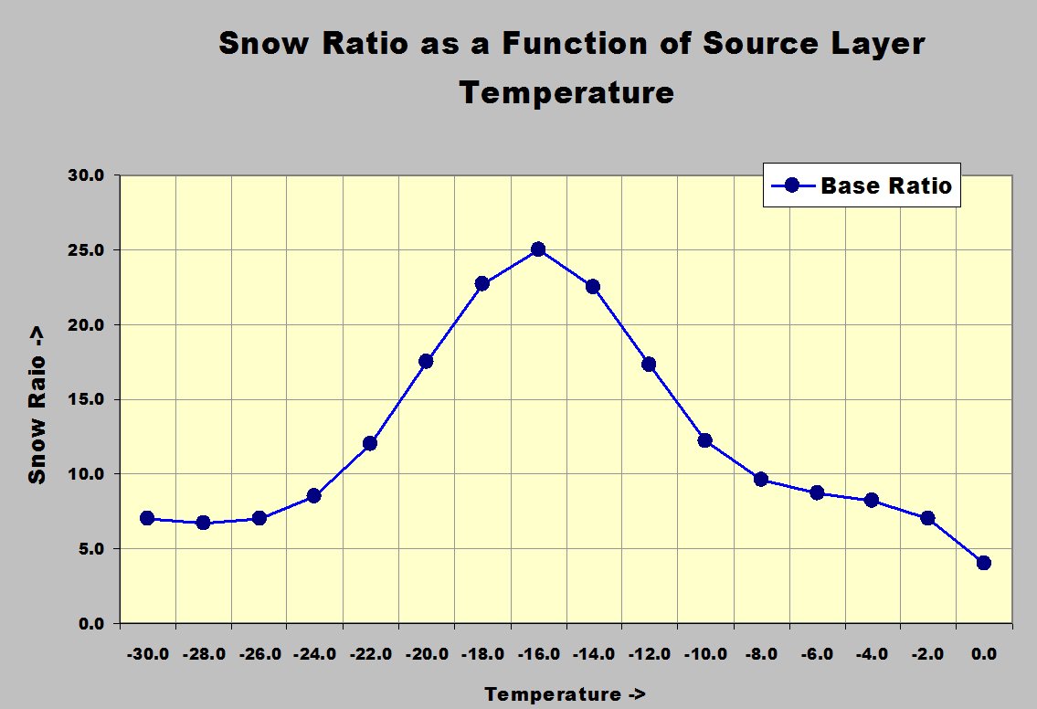
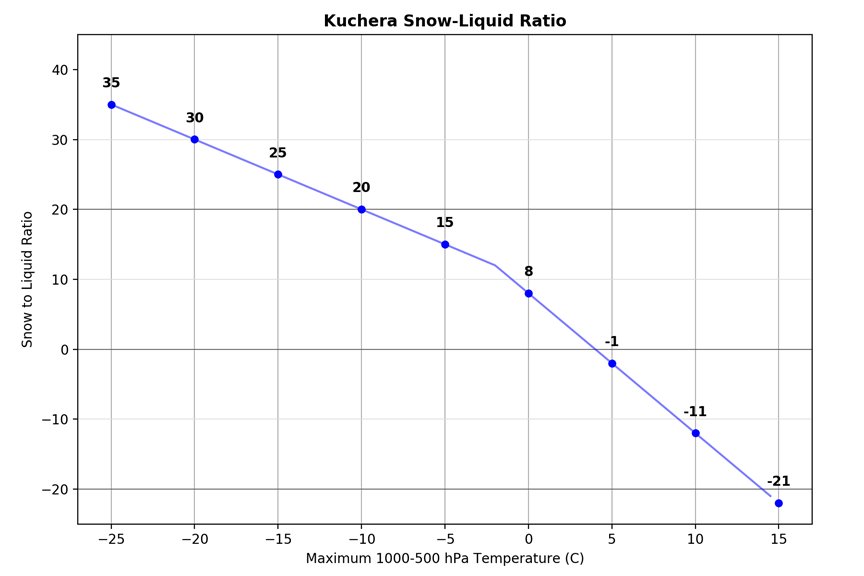
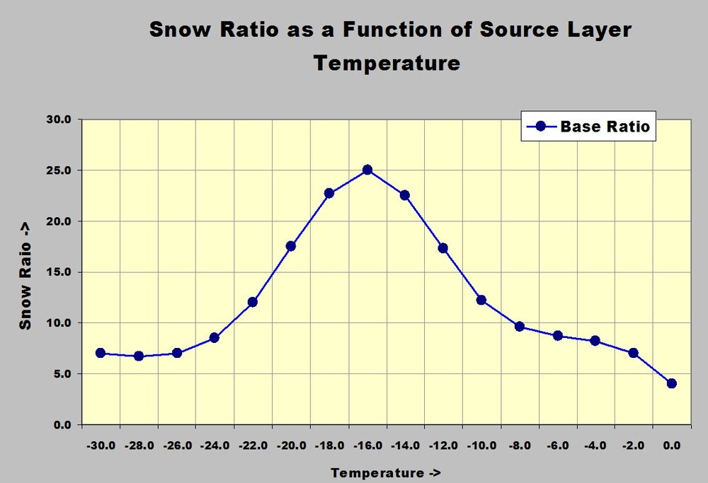
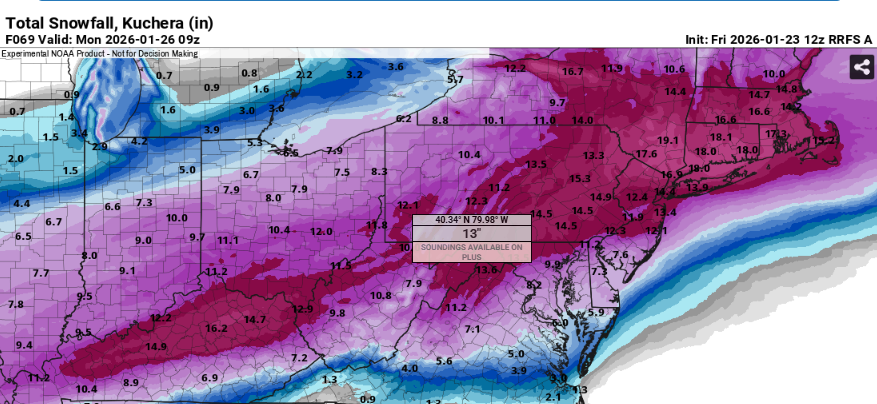
Great summary Im definitely leaning towards a 50/50 blend right now When we're staring at model snowfall maps for the next storm, you'll often see options like the plain old 10:1 ratio (10 inches of snow per 1 inch of liquid) or the Kuchera method, which a lot of sites use because it's supposed to be smarter. The Kuchera approach looks at the warmest temperature anywhere in the atmospheric column (usually up to about 18,000 feet) and plugs it into a formula to tweak the ratio. If that max temp is really cold (say below about -2°C or 28°F), it can spit out fluffy ratios well above 10:1—sometimes 20:1 or more—while warmer columns drop it down toward 5:1 or even lower to account for denser, wetter snow or partial melting. It's a quick way to adjust totals without needing super detailed soundings, and it often gives higher accumulations than straight 10:1 in cold-air setups.But here's the catch that a lot of amateurs (and even some pros) overlook: Kuchera basically ignores the dendritic growth zone (DGZ), that magic layer between roughly -12°C and -18°C where those big, starry, branching snowflakes form best. Those dendrites trap tons of air and stack up super fluffy (high ratios like 15:1–30:1+), especially when the whole layer stays saturated and deep. Kuchera just keys off the single warmest temp in the column, so it can seriously underestimate snowfall in setups with a nice, cold, deep DGZ even if the column max isn't ultra-frigid, or overestimate in marginal/warm cases. Next time you're comparing maps, check model soundings for how beefy that -12° to -18°C layer looks Sent from my SM-S731U using Tapatalk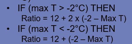
-

“Cory’s in LA! Let’s MECS!” Jan. 24-26 Disco
40/70 Benchmark replied to TheSnowman's topic in New England
Yea, I'm perfectly content with 12-18".....more is a welcome bonus. -
Gonna suck when they have to make some of that up. Back in the day, we had a bad year, and Spring vacation got cut short. Schools are required to have so many days in a year. Unless they have an online set up that qualifies.
-
[emoji817]….. that’s a great point about the rain rates. Some of the worst road conditions I’ve ever been in was freezing fog. .
-

January 24-26: Miracle or Mirage JV/Banter Thread!
clskinsfan replied to SnowenOutThere's topic in Mid Atlantic
I dont know that I have ever seen this much of the country covered by a WSW at the same time before. Nuts. -

“Cory’s in LA! Let’s MECS!” Jan. 24-26 Disco
Baroclinic Zone replied to TheSnowman's topic in New England
We take down this way. Pound town -

“Cory’s in LA! Let’s MECS!” Jan. 24-26 Disco
Kitz Craver replied to TheSnowman's topic in New England
What’s way? -
I noticed they got small craft advisorys for you and down the bay for gusts if 30 mph that combined with low visibility makes me wonder if that approaches blizzard criteria
-
That would be just like PDII, have had that feeling since the get go.
-
I think a changeover for everyone Baltimore and south is pretty much guaranteed. Backend isn't out of the question with a better transfer. But to get the sort of transfer that keeps us snowing the whole time feels nearly impossible. I'm hoping I'm wrong of course but all snow is not in my mind anymore. Still think with a wet thump and a slight adjustment to temps, we can get double digits in the metros or maybe even a foot (better chances in Baltimore) before mixing but that's at best like an upper quintile outcome.
-
1/24-1/25 Major Winter Storm - S. IL, IN, MI and OH
TimChgo9 replied to A-L-E-K's topic in Lakes/Ohio Valley
I was living in Fort Worth, TX for the 2021 storm. They had planned "rolling blackouts" to conserve the grid. First rolling blackout came at about 3am, there was nothing rolling about it. It was off for 12 hours, came back on long enough to get the house warmed up a little, and then go out again. I don't wish prolonged power outages on anyone. -

January 2026 regional war/obs/disco thread
Prismshine Productions replied to Baroclinic Zone's topic in New England
32 degree line down to freaking Tampa Sent from my SM-S166V using Tapatalk -

Pittsburgh/Western PA WINTER ‘25/‘26
jwilson replied to Burghblizz's topic in Upstate New York/Pennsylvania
If you look at thermal profiles, you have the EURO/Canadian/NAM in one camp and the GFS in the other. The 6Z Euro was a slight step colder to a bunch of previous runs, as were the 12Z NAM and 12Z RGEM. Most of the models bring the 850s and surface temps above freezing up to Morgantown, while the GFS remains the most progressive with the transfer. Really, that transfer to the coastal low taking over as the primary is the key element regarding our thermal progression. If the primary low inland continues to dominate longer and maintains a northward push, that's how we get the warm tongue. The depth of the antecedent cold air should give us an advantage. The overall blocking is limited, though, which is why we're even talking about this. I guess you'd typically take a blend and cut the middle road, which should still keep PIT and most of the surrounding areas snow, but with the GFS kind of on an island, you'd take a bit less of it. I think Morgantown is a much trickier forecast. They could end up with 6" of pure snow and then a mix to rain. Either way, NWS will have to revise totals down for some of West Virginia, I think. GFS is the only model that keeps the state fully frozen. I don't think I'll be totally comfortable until we get most of the high-res models in range. It's a very delicate microclimate feature for our area. Those of you north of the city proper have nothing to worry about, though. The only other question is snowfall enhancement with the passing of the upper level trough after the main vort is through. Next weekend has potential, too, but it's a bridge too far right now. -
 12Z NAM looked way better for NYC, RGEM slightly worse, expect some wobbling, going to be close in terms of mainly snow vs several hours of sleet but I think we are narrowing the borderline area to 30 miles north and south of the I80 corridor.
 -

January 24-26: Miracle or Mirage JV/Banter Thread!
caviman2201 replied to SnowenOutThere's topic in Mid Atlantic
at least I meltdown in banter -

January 24-26: Miracle or Mirage JV/Banter Thread!
wxdude64 replied to SnowenOutThere's topic in Mid Atlantic
So true, many, many days I loaded up onto the bus as the snow was falling and roads had been covered for a couple hours. Can't remember the year (but I was in elementary, so pre 1976) and the older teens got off the bus and helped the driver put the chains on the bus, going TO school. Our route picked everyone up in neighborhood and dropped the youngsters off at elementary before taking HS kids on to school. That is a no-no nowadays, as is the fact that 90% of the time the last stop or two STOOD in the isle because the seats were full. -

“Cory’s in LA! Let’s MECS!” Jan. 24-26 Disco
SouthCoastMA replied to TheSnowman's topic in New England
Should change to sleet/snizzle here, but still looking like 10-12" - maybe we can start ticking south a few miles. -
They haven’t issued yet there still under a watch
-
Can't text and drive lol
-

Pittsburgh/Western PA WINTER ‘25/‘26
colonel717 replied to Burghblizz's topic in Upstate New York/Pennsylvania
-
Rufus way south
-

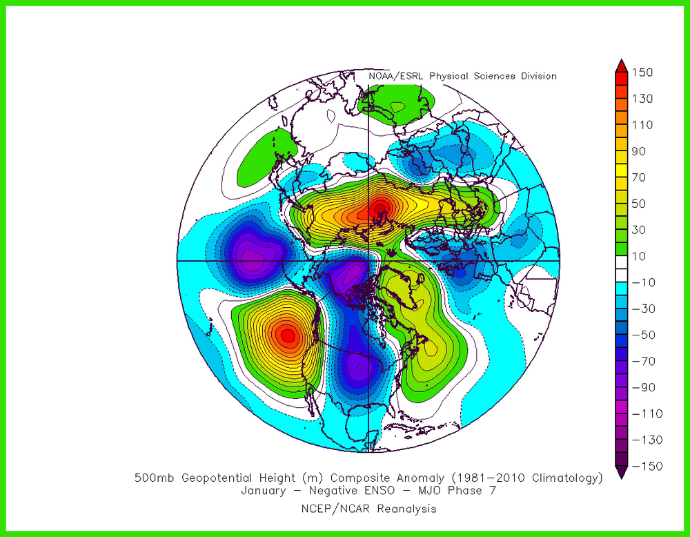
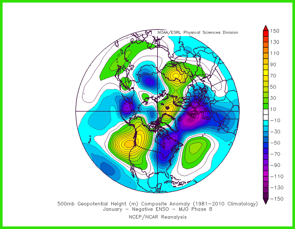
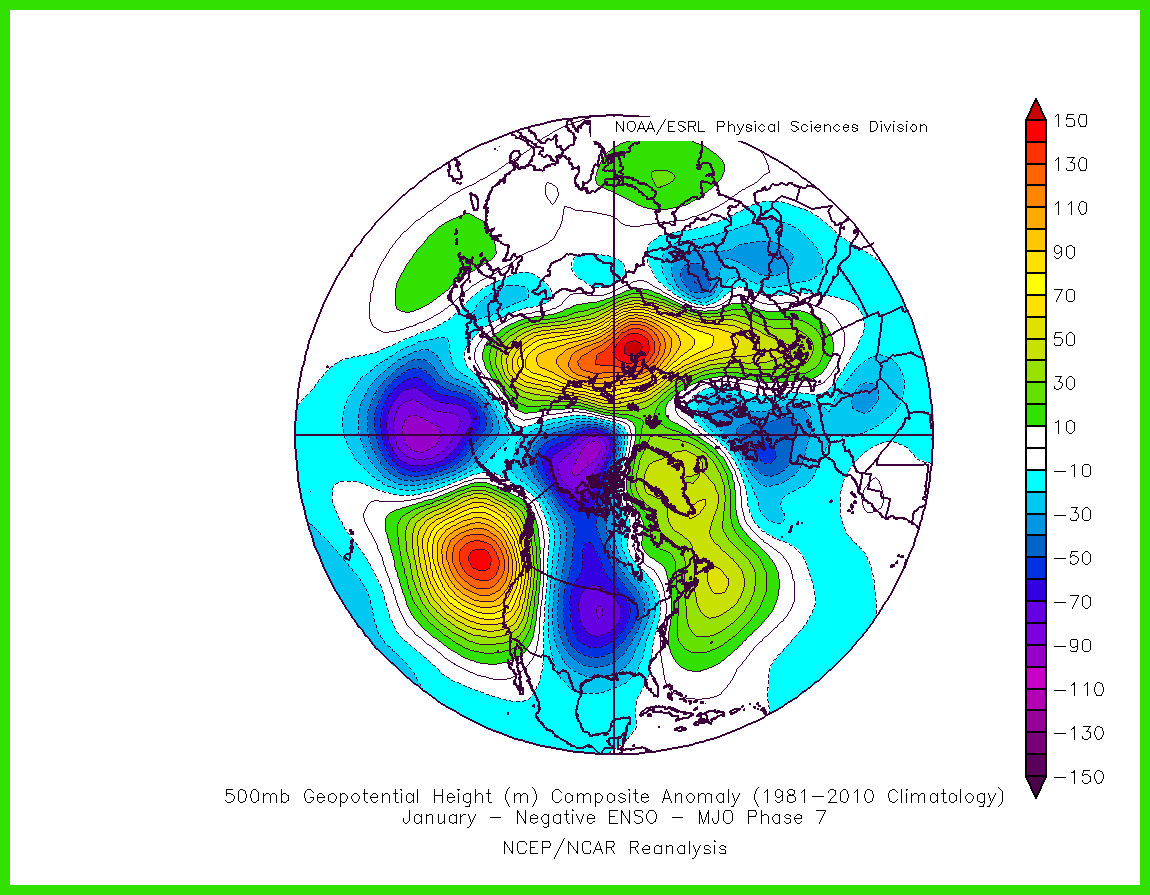
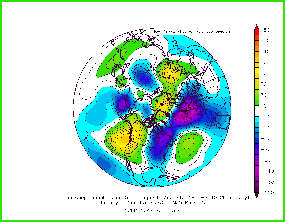
2025-2026 ENSO
so_whats_happening replied to 40/70 Benchmark's topic in Weather Forecasting and Discussion
Phase 8 in February starts to get ok but phase 1 in February in Nina is a large warm up. If we have more of a neutral state rather than La Nina by then with a passage through phase 1 in February it is a bit more muted of a warm up. Looks fun though coming up for at least the next maybe 10 days. https://www.meteonetwork.it/models/mjo/