All Activity
- Past hour
-
oh yeah ... clocks go ahead an hour this Sunday. Finally getting models in the middle of the night - thank god
-

Late February/Early March 2026 Mid-Long Range
stormtracker replied to WxUSAF's topic in Mid Atlantic
1 got one more in us. Mark my words. Enjoy the warmth while you can. I’m not yielding until I have to. We gotta stop this nonsense of giving up on March. -
Neck and neck between you and Central Park. Badhow just that north central portion of the county was scrooed so far. Even the northwest sections I believe are all in the 50's @snywx . Lets see what we can squeak out tomorrow. As long as it doesn't mess with my flight out of Newark tomorrow afternoon. Looks like we @Juliancoltonpicked a good week to leave. No fears of much winter weather to be missed the 3-10 period.
-
Spring Discussion Thread has been posted....
-
Sure looks like a severe signal showing up between 200-240 hours.
-
69”
-

Outta gas and Outta Time: Early March Winter Storm finale
yoda replied to Ji's topic in Mid Atlantic
Special Weather Statement National Weather Service Baltimore MD/Washington DC 930 AM EST Mon Mar 2 2026 DCZ001-MDZ013-014-503>506-VAZ039-040-051-053-054-501-502-505-506- 526-527-022030- District of Columbia-Prince Georges-Anne Arundel- Northwest Montgomery-Central and Southeast Montgomery- Northwest Howard-Central and Southeast Howard-Madison- Rappahannock-Culpeper-Fairfax-Arlington/Falls Church/Alexandria- Northern Fauquier-Southern Fauquier-Western Loudoun- Eastern Loudoun-Northwest Prince William- Central and Southeast Prince William/Manassas/Manassas Park- Including the cities of Washington, Bowie, Suitland-Silver Hill, Clinton, College Park, Greenbelt, Laurel, Camp Springs, Glen Burnie, Annapolis, Severn, South Gate, Severna Park, Arnold, Odenton, Germantown, Damascus, Bethesda, Rockville, Gaithersburg, Silver Spring, Lisbon, Columbia, Ellicott City, Madison, Culpeper, Reston, Herndon, Annandale, Centreville, Chantilly, McLean, Franconia, Arlington, Alexandria, Falls Church, Warrenton, Turnbull, Purcellville, Leesburg, Ashburn, Sterling, Haymarket, Dale City, Manassas, Woodbridge, Lake Ridge, and Montclair 930 AM EST Mon Mar 2 2026 ...LIGHT SNOW EXPECTED MIDDAY AND AFTERNOON... * WHAT...Snow midday and afternoon, accumulating around an inch on unpaved surfaces. Some slushy accumulation on paved surfaces possible. * WHERE...The Washington Metropolitan area, northern Virginia, and central Maryland. * WHEN...The steadiest snow is expected between noon and 5 PM this afternoon. * IMPACTS...In bands of heavier snow, road surfaces may become slushy or even snow covered for a brief period this afternoon. For this evening, any standing water or slush may freeze with temperatures around 30 to 32 degrees. -

Outta gas and Outta Time: Early March Winter Storm finale
EastCoast NPZ replied to Ji's topic in Mid Atlantic
Already above freezing here. Another nothingburger on tap. Fitting end to this winter. -

E PA/NJ/DE Spring 2026 Obs/Discussion
JTA66 replied to PhiEaglesfan712's topic in Philadelphia Region
September is only 6 months away, 189 days until Labor Day! Kids will be back in school, the NFL will be getting underway and Lowe's & Home Depot will have Christmas decorations out! We'll be tracking again before long! -
Didn't realize LGA changed their number from 22.5 to 23.4. I'll have to fix that in the map
-
This year’s El Niño will very likely become a strong event. Yet another series of strong westerly wind bursts over the central Pacific will trigger a new downwelling Kelvin wave that further suppresses the thermocline in the East Pacific a few months now. https://x.com/webberweather/status/2028468392550924638?
-
Guaranteeing something that will probably happen
-
you have a season to date total 65.25 on the sig is right? @Damage In Tolland as well
-

Outta gas and Outta Time: Early March Winter Storm finale
paulythegun replied to Ji's topic in Mid Atlantic
Early radar hallucinations show a VIOLENT VIRGABAND setting up right over the city of DC. The band is being enhanced by a RICH MOISTURE FETCH out of Kansas -

Central PA Spring 2026 Discussion/Obs Thread
Mount Joy Snowman replied to Voyager's topic in Upstate New York/Pennsylvania
Totally missed the spring thread, hello all! My low was a chilling 21 last night and I continue to think tomorrow morning's commute could be quite problematic with a pre-dawn arrival of the precip. 12z Hi-res guidance seems to be coming it a bit colder on average and some are insistent on a good inch-plus of snowfall. Even if not, I think ice accretion will be quite efficient. While yes, the system looks a bit moisture starved, freezing rain accumulates the best at light rates. With last night dipping so low, if today stays mostly cloudy and mid 30s and tonight drops back into 20s I don't think we have any temp issues whatsoever. If it starts as snow I think we get almost immediate stickage. I just think this is one of those classic events that is getting little attention and no one thinks anything of until everyone goes to pile in their cars between 6-8am tomorrow morning and realizes "oh crap". I could be wrong and this could end as mostly a nothing burger, but I think the timing and temps will be in place to make this an impactful event. -
Trace
-
Yeah he said after lol. Everybody knows it's gonna get warm this is an easy forecast. Looks like it gets cold after though that's what he's talking about
-
Looks like its snow here.
-
Good God I hope not
-
Fast moving TX Panhandle to Detroit cutters seem like an option in that baseline pattern, too.
-

Central PA Spring 2026 Discussion/Obs Thread
Itstrainingtime replied to Voyager's topic in Upstate New York/Pennsylvania
I think (?) we should all be posting in the same thread to avoid confusion and lack of continuity - some are posting in one thread, some in the other, and some are posting in both. Messages/thoughts are going to be missed this way. -
I hope we get a surprise inch or two of snow to make up for yesterday's nothing burger This can't be it for the season....as bad as it is in this death valley there's got to be a little more to squeeze out of Mother Nature. End of the week looks horrible
-
tracking heat
-
Wild
-
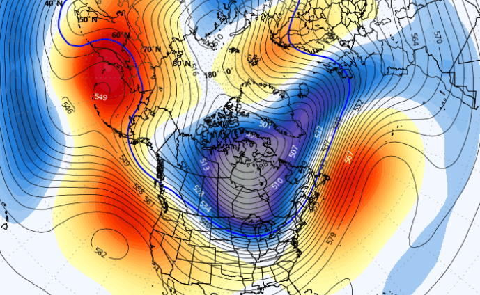
It's poor timing on the season, really This hemispheric super synoptic layout/behavior could have very well set up in Dec or Jan or early in Feb, but instead by happenstance does so in March, when the climate clock and solar recovery are not only ticking... but, time seems like it is speeding up to Old Man Winter. Just sayn' This pattern doesn't scream "end" to me though - all three major ens systems hitting this hard. Overnight EPS for 300 hours PV on our side of the hemisphere with -2 SD anomalies anchoring over the Canadian archipelago means that cold is aplenty. Whether it delivers in the right times and spaces to be involved in events at our latitude? It won't be because winter has intrinsically ended, it means being bent over and sore butted by chance ... those are different predicaments to suffer. LOL. Either can certainly happen in March. My suggestion is just to keep your "expectations" sufficiently lubed at all times such that when chance invades your dignity it won't be as painful. I will say though .. part of keeping expectations in check, notice that this PV is underpinned by modest +anomalies? Those anomalies are actually "potentially" much higher, but the PV being of greater magnitude is compressing the heights to the point where it masks that potential. But that potential is going somewhere and it is converted into velocity (U component) of the westerlies... consequentially being higher than normal. Speed isn't an auto 86er on chances... but it does cause needle threading this, as well as sheer reductions in amplitude that.