All Activity
- Past hour
-

December 2025 regional war/obs/disco thread
moneypitmike replied to Torch Tiger's topic in New England
good luck. -

December 2025 regional war/obs/disco thread
Sey-Mour Snow replied to Torch Tiger's topic in New England
I like 2-4” for ct as of now as a ceiling, hoping we start locking in and mid levels produce some good growth and fluff. But we really can’t afford a gfs euro compromise if so it’s a coating to 2” type deal. -

Winter 2025-26 Medium/Long Range Discussion
Baum replied to michsnowfreak's topic in Lakes/Ohio Valley
Yes. It was. -
Winter 2025-26 Short Range Discussion
Baum replied to SchaumburgStormer's topic in Lakes/Ohio Valley
Ground zero -

December 2025 regional war/obs/disco thread
Baroclinic Zone replied to Torch Tiger's topic in New England
Yeah, this thing is hauling ass and our trough just does not amplify enough. I see at most a 1-3” type deal. Will still make for a festive mood and raise those ‘s spirits. I’m not sure we see a full whiff. -
GFS mid to upper 70s Christmas Day. Euro gets a small front through on Christmas but 70s on Christmas Eve. Yuck
-

December 2025 regional war/obs/disco thread
Damage In Tolland replied to Torch Tiger's topic in New England
I’m fully expecting 3-5” inch type deal of fluff . Small chance it amps more , but as of now that’s what it looks like -
I was thinking the opposite. Imo it has some boom potential, especially from AA County NE towards South NJ. It doesn't look great for the snow drought areas.
-
Santa got his shorts for Christmas?
-

December 2025 Short/Medium Range Forecast Thread
Carvers Gap replied to John1122's topic in Tennessee Valley
That post was from November 21st as an example of how quickly things changed(back to cold) in modeling. I was commenting at the time about a standing wave which never materialized in reality. I will have some comments hopefully this morning about the possible upcoming pattern change to a ridge over the East. And yes, I do think it is probably a pattern change which will last through the last ten days of December and through most of January....but that isn't a slam dunk just yet, but more of a strong likelihood. -

Minor snow possible sunday 12/14/25
MJO812 replied to WeatherGeek2025's topic in New York City Metro
Euro shifted slightly north with the precip. 1-3 inches is a good call. Nice little event before it warms up -

Central PA Winter 25/26 Discussion and Obs
Superstorm replied to MAG5035's topic in Upstate New York/Pennsylvania
I feel the weekend we will see a snow event marking the start of the pattern change to warmer weather. . -

December 2025 regional war/obs/disco thread
Snowcrazed71 replied to Torch Tiger's topic in New England
Do like I did with him and a few others. I just blocked him. He won't stop and he will not be flagged. J -

Minor snow possible sunday 12/14/25
BxEngine replied to WeatherGeek2025's topic in New York City Metro
Regionwide in the next region south of us…. -
Troll should be 1 posted
-
Sign me up as well.
-

Central PA Winter 25/26 Discussion and Obs
mahantango#1 replied to MAG5035's topic in Upstate New York/Pennsylvania
Took this pic yesterday afternoon when it was snowing. The creek is freezing over. Imperssive for this time of year. -
06z euro improved again after the regression at 00z. I don’t think this one has a high ceiling though. There’s just not enough room. But it could be a solid advisory event maybe.
-
Still looks good for DC
-
December 2025 regional war/obs/disco thread
Snowcrazed71 replied to Torch Tiger's topic in New England
Well, I guess things went south overnight. Sucks. -

Winter 2025-26 Medium/Long Range Discussion
A-L-E-K replied to michsnowfreak's topic in Lakes/Ohio Valley
looking at the eps this morning -

December 2025 Short/Medium Range Forecast Thread
Holston_River_Rambler replied to John1122's topic in Tennessee Valley
URGENT - WINTER WEATHER MESSAGE, HOLSTON'S WEATHER EMPORIUM, Mossy Grove, TN 6:30 AM EST ****YE OLEN CLIPPER WARNING*** * WHAT...Light to occasionally moderate snow. Snow accumulations 1 to 4 inches, greatest across higher terrain. Winds gusting as high as 7 mph will produce pretty sights. * WHERE...Eastern KY, SW VA, and possibly Bristol, TN and Mountain City, TN The greatest additional accumulations will focus across the higher terrain of the High Knob and peaks on the KY and NA border above 2500 feet. * WHEN...Starting late this evening * IMPACTS...Plan on some snow covered and slippery road conditions as well as the comfortable ease of a clipper's accumulations. Hot chocolate is recommended for these trying times. SUMMARY...SW VA and eastern KY is in danger of getting hit by the first traditional clipper to hold together all the way to the southern Apps region in what seems to me like 7.5 million years. Some of the Hi Res models clip extreme NE TN too. Pretty much all the Hi Res models show the same thing, even the ever stingy NBM. -
The 6z Euro is perfect for my backyard
-
Gusty winds and flurries here this morning. Peak gust was 41. Saw that Camp David gusted to 53 overnight. 32°
-
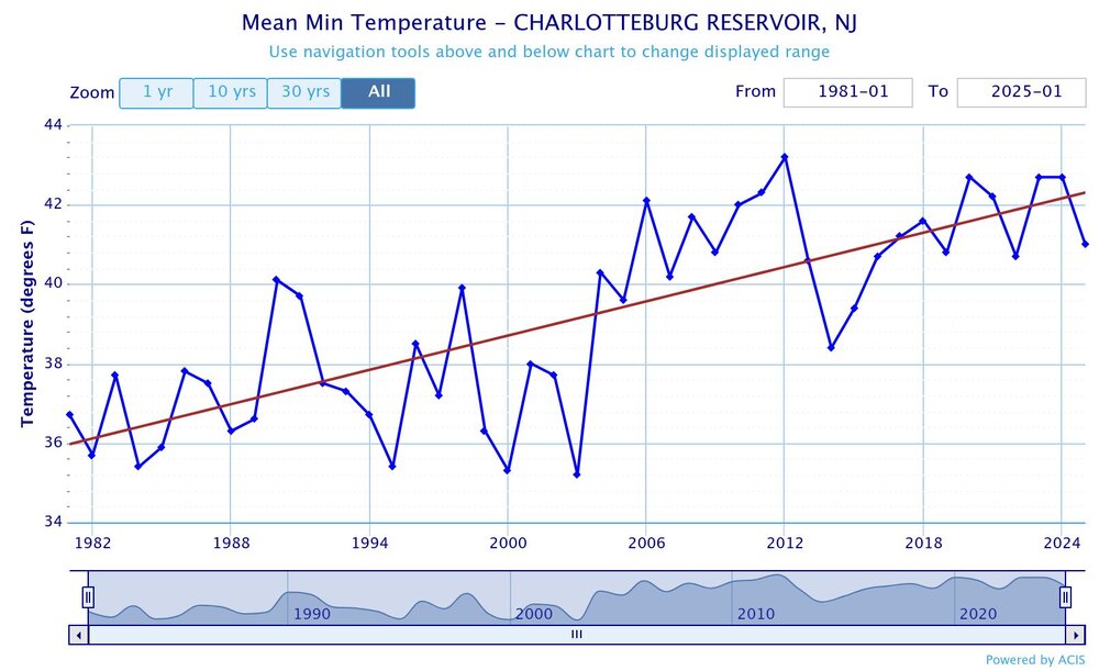
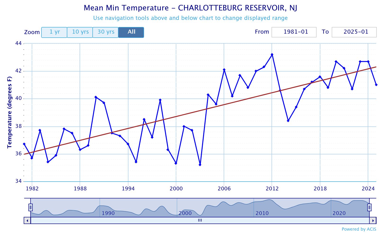
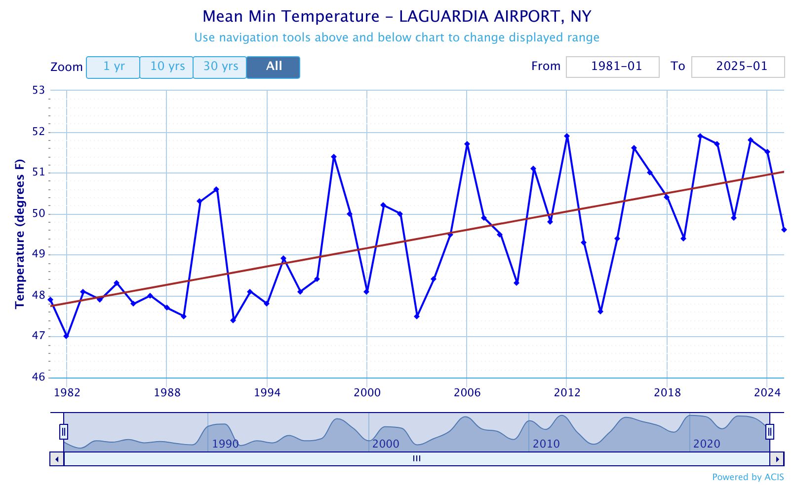
I grew up in Long Beach on the South Shore and we only needed the AC a handful of times back in the 1970s. First for the August 1973 heatwave and then the July 1977 heatwave. We gradually increased the AC usage during the 1980s and especially the early 1990s. By the time we reached 2010, we had three ACs running much of the time compared to only one in the 1970s. Plus there was a rapid expansion of central AC even in Long Beach when it was a rarity near the shore in the 1970s. This is one of the reasons that HVAC is such a good career opportunity for people due to the increased demand in a warming world. As for the UHI issue, there was a 10°+ difference between NYC during 1896 heatwave and the surrounding countryside. This mostly occurs with summer heatwaves where the city absorbs more heat during the day. It also occurs during calm and clear nights with radiational cooling. The growth of skyscrapers in Western Brooklyn and Queens certainly changes the character of the neighborhood and of course you can see the change in the skyline since around 2004. But prior to that that area had densely packed lower rise buildings built of bricks. These new high rises are mainly glass and steel which absorb significantly less solar energy than bricks do. Plus a cluster of tall buildings will create a big area of shade which prevents the streets and sidewalks from absorbing as much heat as they did with smaller buildings with less shadows. The warmest parts of NYC are in Queens near spots like Corona were small to medium size brick structures dominate. So changing from lower rise brick and concrete structures to skyscrapers may not change the UHI much in Western Brooklyn and Queens to really be noticeable to residents there. That’s why I said a drop in the bucket to what was already one of the largest UHI zones in North America. The rural and suburban areas have warmed at a similar rate to places like Corona Queens over the years. So this is why both areas require more summer AC usage than they did during the 1970s. My guess is that the higher dewpoints and maybe stronger winds are probably why a rural spot like the Charlotteburg Reservoir has seen a steeper increase in low temperatures than LGA since 1981.