All Activity
- Past hour
-

Central PA Winter 25/26 Discussion and Obs
Superstorm replied to MAG5035's topic in Upstate New York/Pennsylvania
It shows the better CAD signature you want to see. . -

Possible Record Breaking Cold + Snow Sunday 1/25 - Tuesday 1/27
SACRUS replied to TriPol's topic in New York City Metro
ICOn 12z Total QPF storm -

Possible Record Breaking Cold + Snow Sunday 1/25 - Tuesday 1/27
MJO812 replied to TriPol's topic in New York City Metro
Icon.thumb.png.209ed6527ace1ad77c2d3cfeb16270cd.png)
.thumb.png.75f05eaa34c6c1514f2e92a0868ab4ee.png)
-
PREACH
-
All those people that were talking about tearing down the mountains last month should take note.
-
I'll be happy when the warm nose is down near kings dominion and riding the fucking berzerker
-

January 2026 regional war/obs/disco thread
JKEisMan replied to Baroclinic Zone's topic in New England

-
Pretty sure that was rather delightful sarcasm from WxUSAF
-
Gonna need a salt washer soon but it may be a while. It’s the next best thing to snow.
-
They always are. Not exactly the model to look at for that stuff.
-

Central PA Winter 25/26 Discussion and Obs
pasnownut replied to MAG5035's topic in Upstate New York/Pennsylvania
Icon at 84 slightly north of 6z -
Frankly I think the ICON was close to being way better, am I crazy? It left a lot of energy behind from the Baja piece but still amped more than prior runs. I’m sure it’s possible to get that but with this Arctic front and a messier phase as depicted I think the progression could end up better. I guess I’m just wishcasting
-
.thumb.png.4150b06c63a21f61052e47a612bf1818.png)
January 2026 regional war/obs/disco thread
HIPPYVALLEY replied to Baroclinic Zone's topic in New England
Maybe he moved from Lowell to Ayer? -
Long time lurker first time poster. ICON a looks a little better with regards to the phasing out west. IMO thats our biggest player at the moment. HP is here and even though it’s a bit transient at the end, still cold enough. We just need the storm to phase less/slower out west. Little differences out there make big differences here.
-

January 2026 regional war/obs/disco thread
CoastalWx replied to Baroclinic Zone's topic in New England
Icon looks nice -
I mean I don’t want sleet either but not gonna let it ruin it for me. Yall do yall tho
-

Central PA Winter 25/26 Discussion and Obs
GrandmasterB replied to MAG5035's topic in Upstate New York/Pennsylvania
That’s a thing of beauty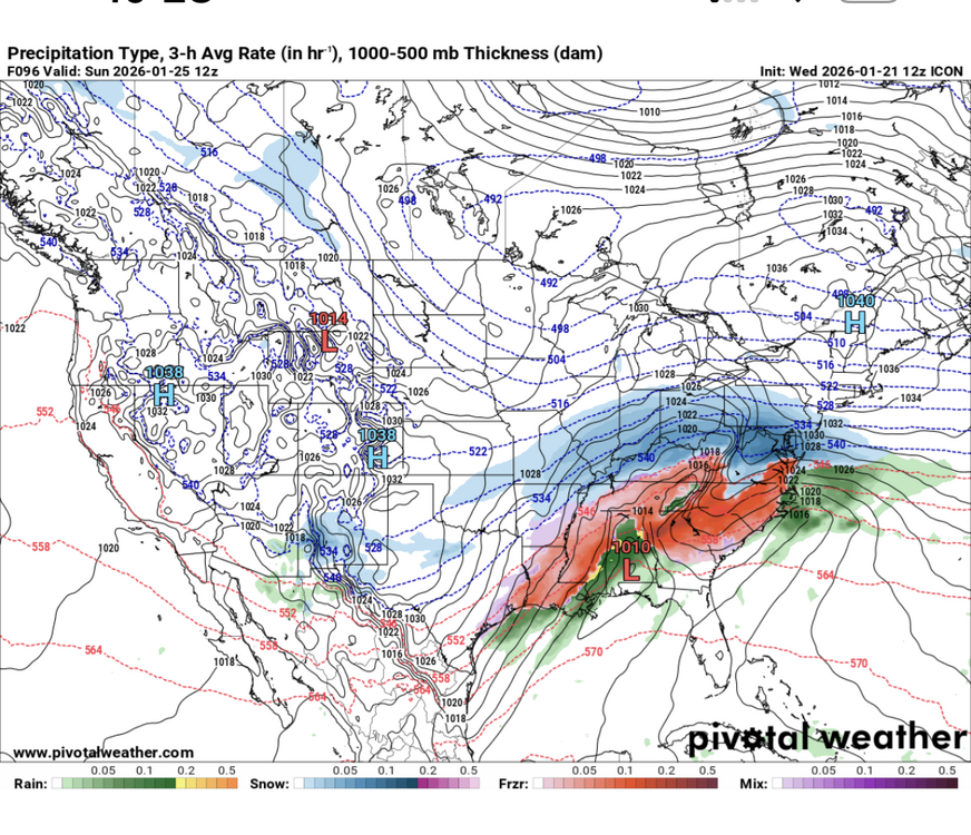
-
The 12z ICON has a low in the Panhandle at 96 w/ a faint reflection west of the Apps. Looks icy...very icy for most of the forum area. It does try to form a Miller A, and that must be watched w/ a slp in the Panhandle, but it just isn't organized enough. Not a textbook cut, but some energy transfer is evident. Main low stays along the Panhandle into souther Georgia. The reflection into the Tennessee Valley causes thermals to get wrecked...and it produces ice.
-
January 2026 regional war/obs/disco thread
CoastalWx replied to Baroclinic Zone's topic in New England
I’ll likely be wrong in that regard. I admit. -
Altho the ICON snowfall maps are a little underwhelming considering. **Let me clarify! Underwhelming relative to what it appeared to be from the sfc maps...10 inches of snow is not underwhelming.
-
My thoughts exactly. West of 95 is looking pretty solid for 90+% snow. Our area should be all snow
-
I’m on your side man and I hope that’s the case. We’ve certainly seen suppression win the past few years. Hope I didn’t seem argumentative. I just wanted to support what I was saying and not just come across as a Debbie downer.
-
I hate the word decent. What if I said your work performance was decent. It’s like insulting Right lol
-
Seems like this could turn into a classic sleet slop fest for I-70. Seen it too many times
-
The last few days have been crazy busy for me and I have not had time to scroll through 75 pages to get caught up so I apologize if any of this is redundant but some thoughts on where we are right now after looking at everything 1) I was never concerned with suppression, and frankly I never thought anything actually showed that...the runs that were south were because the energy got stuck out west and only weak waves ejected which of course would slide east under the cold dome. That's not suppression. There was never anything showing some wall of immovable confluence with the typical sharp northern cutoff of precip you see in true suppression. The greenland block is centered north of ideal actually, up over northern Greenland...not Baffin, and the 50/50 is ideal...and relaxing as the wave approaches not some vortex over Maine like we see when a storm gets suppressed. This never looked like that was the issue. 2) However, I am also not overly concerned this turns into some non event from a north trend. While the greenland block is north of ideal, there is one of the most impressive ridge bridges to a poleward EPO ridge that I have ever seen and a strong 50/50 feature. There is an arctic high in the way. And the low and mid level cold starts out really far south. This system has a lot of similarities to the February 2007 storm but the mid level cold is penetrating about 100 miles further south in this storm. That system I was always worried leading in because the cold really wasn't set up far enough to our south as the WAA started. This time...there is a limit IMO to how far north this can go because the low and mid level cold is really pressing ahead of it. I do think we might mix, but the worst case scenario would be a result for DC and Baltimore similar to 2007 but displaced about 75-100 miles south...meaning DC could experience what Harrisburg PA got during that 2007 storm, which was about 4-6" of snow followed by 4-5" of sleet and freezing rain and in the end had 10" of a concrete glacier OTG and a major impact event. I know everyone would prefer 2 feet of cold smoke powder, and a ton of snow is still possible, I'm just saying I don't think this can turn into some predominantly rain event...this is either a huge snowstorm, or at worst a decent snow turning into a prolific sleet/ice event. Right now I would lean somewhere in between, with the most likely outcome being a big snow before mixing with sleet in the cities.
.png.92680efc58684594e38dced0bb4f35c6.png)


