All Activity
- Past hour
-

2026-2027 Super El Nino
snowman19 replied to Stormchaserchuck1's topic in Weather Forecasting and Discussion
Which super El Niños were cold winters (Dec-Mar)? 72-73: warm, 82-83: warm, 97-98: warm, 15-16: warm -
About a tenth overnight, about that much since the 7 am report. MUGGY, MUGGY, MUGGY! 71.2/70.0 currently with light rain at 9:30 am.
-

2026 Mid-Atlantic Severe Storm General Discussion
SnowenOutThere replied to Kmlwx's topic in Mid Atlantic
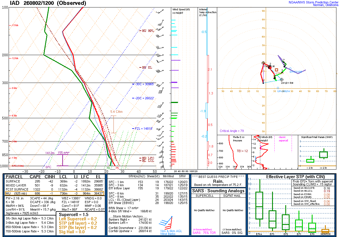
The 12z sounding from IAD seems pretty juiced. Nearly saturated atmosphere all the way up. I think the most interesting thing is how convective temp is only 81 degrees.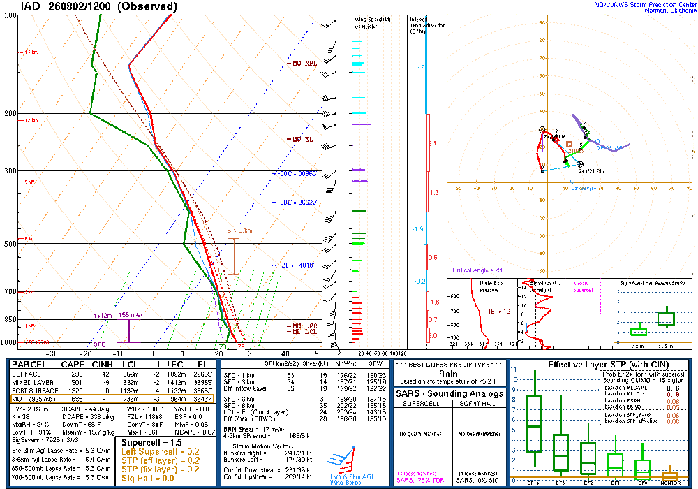
-

2026-2027 Super El Nino
PhiEaglesfan712 replied to Stormchaserchuck1's topic in Weather Forecasting and Discussion
Yeah, I will always point out that the coldest winter CONUS in the 21st century was during a strong la nina. Strong/super el ninos generally mean warmth, but not always. It's too early to tell whether this upcoming winter is going to be warm, but if the models are still showing a cold signal in September, then people need to accept that it will probably be colder (and possibly snowier) winter. -

2026-2027 Super El Nino
bluewave replied to Stormchaserchuck1's topic in Weather Forecasting and Discussion
-

Central PA Summer 2026 Discussion/Obs Thread
Mount Joy Snowman replied to Voyager's topic in Upstate New York/Pennsylvania
Low of only 73 to go along with .01” of rain. -
2026-2027 Super El Nino
bluewave replied to Stormchaserchuck1's topic in Weather Forecasting and Discussion
-
True. It basically never has anything prior to an event. It certainly feels juicy out here.
-
Light rain at the little Bennett trailhead (biked a different loop this time). Perfectly timed…started to rain right at the last stretch. Humidity is thick…the atmosphere no longer wants this area to be in a drought.
-

2026-2027 Super El Nino
GaWx replied to Stormchaserchuck1's topic in Weather Forecasting and Discussion
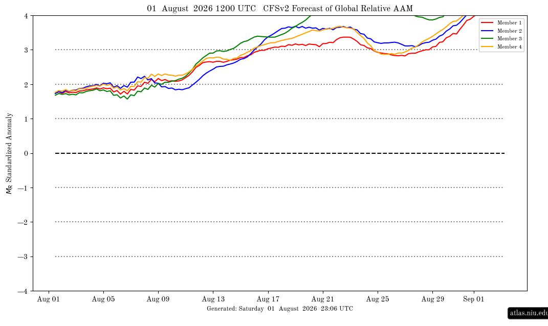
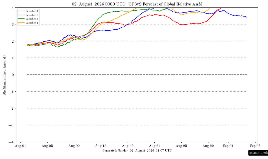
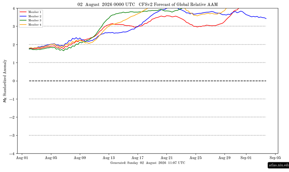
Amazingly, the very next CFSv2 run of AAM (0Z on 8/2/26) is even more extreme overall than the posted prior run making it the most extreme I’ve ever seen although this one never quite gets all 4 at 4+ simultaneously (so the first week and last few days are only parts not more extreme): this one already has two at 4+ at day 20! @snowman19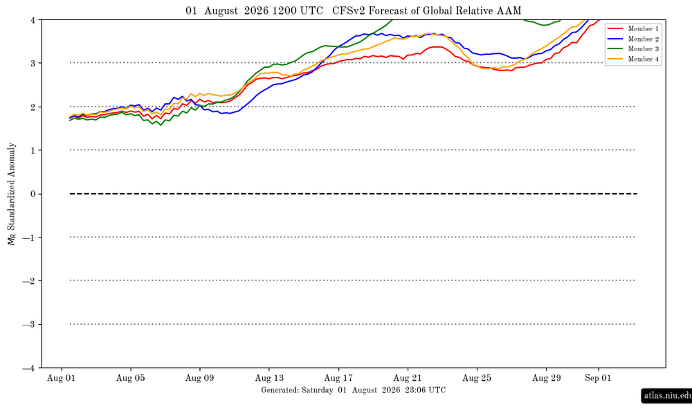
-
Isn't it retiring soon for the RRFS?
-
Picked up 1.02 overnight
-

Augdewst 2026: Summer's Last Stand
CoastalWx replied to Prismshine Productions's topic in New England
Congrats on a soaker. -

2026-2027 Super El Nino
mitchnick replied to Stormchaserchuck1's topic in Weather Forecasting and Discussion
Oh, the "not me, it's you" defense. Lol If you call trying to get to the bottom line of a post/position an attack, I can't help you. But the bottom line is, you haven't denied my synopsis of your post/position because it's accurate. Which is fine. You can take whatever position you want. But clarity matters, that's all. -
 order viagra: generic sildenafil - viagra without prescription
 -
0.26 so far
-
Maybe it’s correct but the NAM has been awful this warm season
-
The NAM says what rain today or tonight for DC and east. The storm to the west just goes north and hits the same ole flooded areas of NY.
-
2026-2027 Super El Nino
bluewave replied to Stormchaserchuck1's topic in Weather Forecasting and Discussion
You posted recently how you don’t care about the weather patterns beyond your own local area. This isn’t a cheap shot since I am simply pointing out your stated stance. You are the main person in this thread taking cheap shots at others. -

2026-2027 Super El Nino
MJO812 replied to Stormchaserchuck1's topic in Weather Forecasting and Discussion
Dude nothing is set in stone this early. Some of you haven't learned a thing about long range forecasting. -
2026-2027 Super El Nino
MJO812 replied to Stormchaserchuck1's topic in Weather Forecasting and Discussion
Many forecasts are for warmth but they are just going by enso. Many other factors to consider. -
2026-2027 Super El Nino
mitchnick replied to Stormchaserchuck1's topic in Weather Forecasting and Discussion
Oh, the need for a cheap shot can't escape you can it? You've shown your true colors. That was easy. -

2026-2027 Super El Nino
qg_omega replied to Stormchaserchuck1's topic in Weather Forecasting and Discussion
We have the strongest east based Nino on record, it’s going to be an historic warm winter. This is not difficult -
2026-2027 Super El Nino
snowman19 replied to Stormchaserchuck1's topic in Weather Forecasting and Discussion
Here is a very interesting recent study on positive (westerly) QBO’s with El Niños Link: https://agupubs.onlinelibrary.wiley.com/doi/full/10.1029/2024GL112854 Key Points: Westerly Phase Impact: The westerly phase of the QBO suppresses tropical convection in the western Pacific, accentuating the weakening of the Walker circulation typical during El Niño. Observational and model evidence show that the QBO modulates upper-tropospheric divergence, with reduced outflow over the Maritime Continent during the westerly phase. It can also impact the warm phase of ENSO, El Niño, characterized by a weakened Walker circulation. These results suggest that considering the QBO state could improve El Niño prediction and projection, particularly for extreme events. @LakePaste25 @EasternLI @GaWx @donsutherland1 @40/70 Benchmark @Stormchaserchuck1 -
Records: Highs: EWR: 100 (2006) NYC: 100 (1955) LGA: 102 (2006) JFK: 98 (1975) Lows: EWR: 53 (1940) NYC: 57 (1875) LGA: 59 (1953) JFK: 59 (1985) Historical: 1944: A hurricane formed in the Bahamas and came ashore at the North Carolina/South Carolina border. It moved north as a tropical storm, then curved to the northeast, passing across the lower Delaware Bay on its way out to sea. Philadelphia, PA received 2.39 inches of rain and 0.22 inches on the 3rd. This was the first of three tropical systems to affect the Mid Atlantic states in 1944. (Ref. Wilson Wx. History) 1945: Washington, DC had 3.39 inches rain in 3 hours, 4.26 inches in 6 hours and 5.18 inches in 12 hours. (Ref. Washington Weather Records - KDCA) 1954 - Severe thunderstorms produced golf ball size hail for thirty minutes in north central Kansas. One drift measured 200 feet long, seventy feet wide and three feet deep. (The Weather Channel) 1964: Muskegon, Michigan records its hottest day ever with a reading of 99 °F. (Ref. WxDoctor) 1970: At least eight people drowned on Florida Panhandle beaches due to the effects of Hurricane Celia which passed hundreds of miles to the south and made landfall near Corpus Christi, TX. Rip tides and heavy surf with waves up to 10 feet pounded the beaches of Escambia, Okaloosa and Santa Rosa Counties. The Escambia County Sheriff reported 25-30 emergency calls with lifeguards rescuing at least 12 people. (Ref. Wilson Wx. History) 1974: 25 miles east of Buffalo, Wyo.--Lightning struck a party of fishermen, killing one and injuring four others. (Ref. Lightning-The Underrated Killer.pdf) 1975 - Record heat gripped New England. Highs of 104 degrees at Providence, RI, and 107 degrees at Chester and New Bedford, MA, established state records. The heat along the coast of Maine was unprecedented, with afternoon highs of 101 degrees at Bar Harbor and 104 degrees at Jonesboro. (The Weather Channel) Boston, Massachusetts had a 102 °F temperature the warmest temperature for August. (Ref. NOAA Boston Weather Events) 1978: Very heavy rains of 12 to 14 inches fell across the Texas Hill Country during the nighttime and early morning hours causing severe flooding on the Guadalupe River. Up to 30 inches of rain fell during the 3-day period from the 1st through the 3rd. 27 people died in the Hill Country flooding along with tens of millions of dollars in damage. More flooding occurred during the early evening near Abilene, where six people were killed. (Ref. Wilson Wx. History) 1980: The intense heat wave continued in Texas. Dallas had their 41st consecutive day of 100° readings. The streak eventually reached 42 days. Abilene, TX was on their 41st consecutive day of 98° or higher, tying a record that dated back to 1952. El Paso, TX was on their 51st consecutive day of 100°+ temperatures. Other record highs included: Oklahoma City, OK: 110°, Tulsa, OK: 108° and Springfield, MO: 102°. (Ref. Wilson Wx. History) 1985: A strong and sudden wind gusts cause a plane crash at the Dallas/Fort Worth Airport in Texas that kills 135 people. The rapid and unexpected formation of a supercell, an incredibly powerful form of a thunderstorm, led to the tragedy. 1987 - Hot weather continued in the central U.S. Fifteen cities reported record high temperatures for the date, including Concordia KS with a reading of 106 degrees, and Downtown Kansas City, MO, with a high of 105 degrees. Evening thunderstorms produced severe weather in the Ohio Valley and the north central U.S. Thunder- storms in South Dakota produced wind gusts to 70 mph at Philip, and hail two inches in diameter at Faulkton. (Storm Data) (The National Weather Summary) 1988 - Searing heat continued from the Middle and Upper Mississippi Valley to the Middle and Northern Atlantic Coast States. Twenty- six cities reported record high temperatures for the date. Chicago IL reported a record seven days of 100 degree heat for the year. (The National Weather Summary) 1989 - Low pressure representing the remains of Hurricane Chantal deluged north central Texas with heavy rain. Up to 6.50 inches drenched Stephens County, and Wichita Falls reported 2.22 inches of rain in just one hour. Bismarck, ND, reported a record warm morning low of 75 degrees, and record hot afternoon high of 101 degrees, and evening thunderstorms in North Dakota produced wind gusts to 78 mph at Lakota. Early evening thunderstorms in Florida produced high winds which downed trees at Christmas. (Storm Data) (The National Weather Summary) 1995: Hurricane Erin made landfall near Sebastian Inlet in southern Brevard County during the early morning hours. Brevard County bore the brunt of the storm with wind gusts to 100 mph between Melbourne Beach and Cocoa Beach knocking down trees on houses, cars, and power lines. As Erin moved through Orlando during the morning wind gusts to 60 mph downed trees on power lines, houses and cars. About one-half million people were without power initially, several thousand were without power for more than five days. Heavy rains of up to 8 inches in three hours on the backside of Erin hit Brevard County again during the afternoon causing widespread flooding of low lying areas. Erin moved into the Gulf of Mexico during the afternoon as a tropical storm, but regained hurricane strength. Erin then made a second Florida landfall near Pensacola on the morning of the 4th with sustained winds of 95 mph gusting to 110 mph. Damage in the Pensacola area was estimated at $300 million dollars. (Ref. Wilson Wx. History) 1996: Powerful thunderstorms moved across southwest and south central Kansas during the evening hours. In Pratt county eight train cars were blown off the tracks while the train was moving. This occurred one mile west of Cullison. One family was nearly run over by the derailing train cars. One boxcar ended up about 10 feet away from their vehicle. From three miles south of Lewis to Belpre, very strong thunderstorm winds killed calves, blew cars off the highway and blew down 60 power poles. There were unofficial and unconfirmed reports of 125 mph winds recorded on home stations (Ref. Wilson Wx. History) 2000: Massive downburst winds estimated at 90 to 110 mph hit areas from eight miles west of Spearfish, SD to several miles east of Spearfish. Hail, to golf ball size accompanied the high winds and damaged roofs and siding throughout the region, although the winds caused the worst damage. The airport at Spearfish had 27 planes damaged, and seven of those were destroyed beyond repair. Seven hangers at the airport were also damaged or destroyed. Roofing material sliced through an oxygen valve at the Spearfish Trout Farm and killed 100,000 out of 120,000 trout that the family raised. In the Spearfish city campground, more than 150 campers were there, in anticipation of the 60th Annual Sturgis Motorcycle Rally the following week. None of the trees fell on occupied tents, although several fell within inches of where people were sleeping in their tents. In Rapid City, the National Weather Service office measured wind gusts of 70 mph. The storm weakened as it moved southeast of Rapid City, but was still at severe limits as it passed over the Badlands National Park and went southward into Bennett County. Observers in Martin reported 60 mph wind gusts. (Ref. Wilson Wx. History) 2001: Chicago Illinois was pounded by up to 3.50 inches of rain in one hour in the a.m. rush; some interstate expressways were under 8 feet deep water. Some 228 stalled vehicles had to be towed. 10,000 homes had water damage; 50,000 customers without power at the peak of the storm. (Weather Guide Calendar with Phenomenal Weather Events 2007 Accord Publishing, USA) (Ref. WxDoctor) 2008: Denver, Colorado: A 130-year-old high-temperature record falls in Denver, when the mercury hit 103 °F. (Ref. WxDoctor)