
All Activity
- Past hour
-
I'd be willing to bet he was on this forum but packed it in for saner pastures.
-

Augdewst 2026: Summer's Last Stand
Damage In Tolland replied to Prismshine Productions's topic in New England
If 25 days are humid meaning dews 64 or higher .. does that make it a humid month? -
Augdewst 2026: Summer's Last Stand
Damage In Tolland replied to Prismshine Productions's topic in New England
I’d be willing to bet he’s on this forum -
(002).thumb.png.6e3d9d46bca5fe41aab7a74871dd8af8.png)
Central PA Summer 2026 Discussion/Obs Thread
ChescoWx replied to Voyager's topic in Upstate New York/Pennsylvania
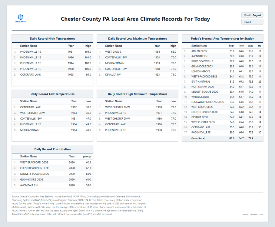
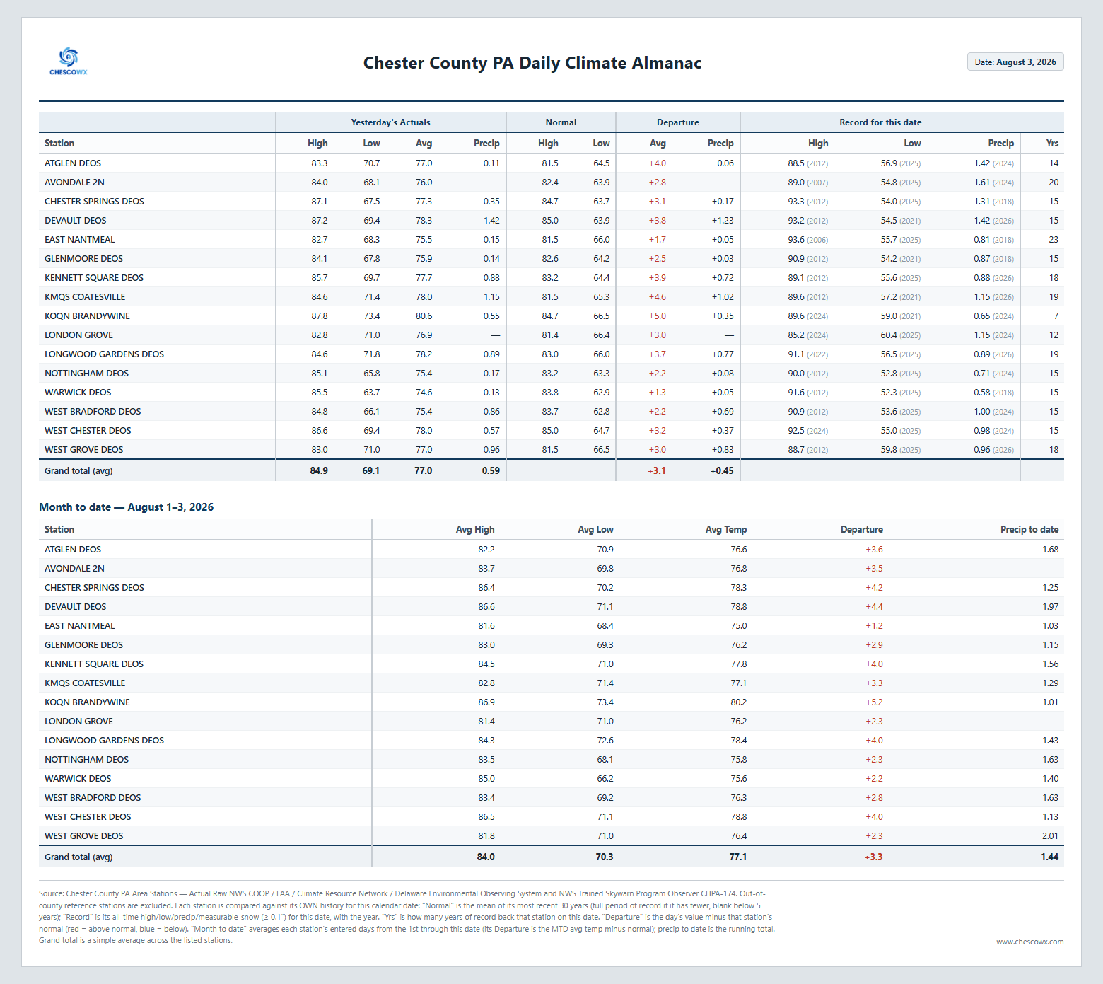
Today will be the most pleasant day of the week with low relative humidity and temperatures not too far from normal for early August. Shower chances increase again later tomorrow and additional chances remain for the rest of the work week. No total washouts but plenty of shower chances.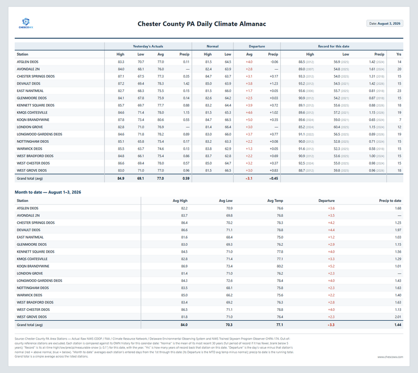
-
E PA/NJ/DE Summer 2026 Obs/Discussion
ChescoWx replied to PhiEaglesfan712's topic in Philadelphia Region
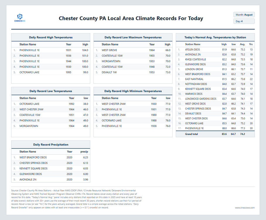
Today will be the most pleasant day of the week with low relative humidity and temperatures not too far from normal for early August. Shower chances increase again later tomorrow and additional chances remain for the rest of the work week. No total washouts but plenty of shower chances.
-

Augdewst 2026: Summer's Last Stand
weatherwiz replied to Prismshine Productions's topic in New England
I enjoy his posts and discussions. Extremely knowledgeable and doesn't try to hype things up...just tells it exactly the way it is. -

2026-2027 Super El Nino
bluewave replied to Stormchaserchuck1's topic in Weather Forecasting and Discussion
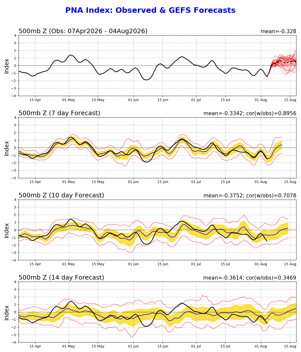
Yeah, that has been the seasonal PDO pattern during the 2020s. Steep summer decline followed by rebound back closer to neutral during the winter. Most summers the 500mb driving influence for the -PDO has been the ridge to the east of Japan. This July the ridge north of Hawaii had a much greater influence. More like what we saw during a more Niña-like July 2012. While the seasonal models have been missing this pattern since May, a rebound to a more +PNA and -EPO from August on is what they have been forecasting. So at least this element of the forecast may be in the early stages of developing. But we are still getting very strong ridge amplifications off the East Coast and in the Southwest in early August which appears to be the lingering La Niña -PDO 500 mb pattern influence. If even a small amount of-PDO influence at 500 mb continues into the winter, then it could mean a weaker or displaced Aleutian low complex relative to 1997-1998. The exact locations of the low pressure would help determine where the Nino ridge axis focuses over North America. Any -PDO 500 mb influence could result in higher heights located south or potentially east of 1998 which when the main 500 mb ridge was centered south of Hudson Bay. -

Augdewst 2026: Summer's Last Stand
ineedsnow replied to Prismshine Productions's topic in New England
Average to slightly below just like last month.. how humid it was? The whole month won't be humid.. 10 days doesnt determine a whole month.. just look at July -

2026-2027 Super El Nino
Terpeast replied to Stormchaserchuck1's topic in Weather Forecasting and Discussion
I think there has been a repeated pattern of the -PDO diving in the warm season with the marine heat wave off Japan through south of Aleutians as a result of the 500mb pattern, and then it abates through the fall and early winter as the NH cools. It will be very interesting to see if the NH atmosphere fully couples with the El Nino once the NH cools, or if the -PDO remains deeply negative. I would not be surprised if the PDO rises to near-neutral levels, but if it doesn't, then we would enter uncharted waters with super nino + super negative PDO. I'm not sure that's ever happened before, at least not at this level. -

Mountain West Discussion
mayjawintastawm replied to mayjawintastawm's topic in Central/Western States
102 to 53 here in about 26 hours... nice!! Uncommon to see such a big temp drop in the summer. -
2026-2027 Super El Nino
bluewave replied to Stormchaserchuck1's topic in Weather Forecasting and Discussion
At least the PNA is trying to match the usual August El Niño expectations. But the other areas still have the lingering -PDO or La Niña influence. So maybe this is the start of the El Niño having of more 500 mb influence on our pattern.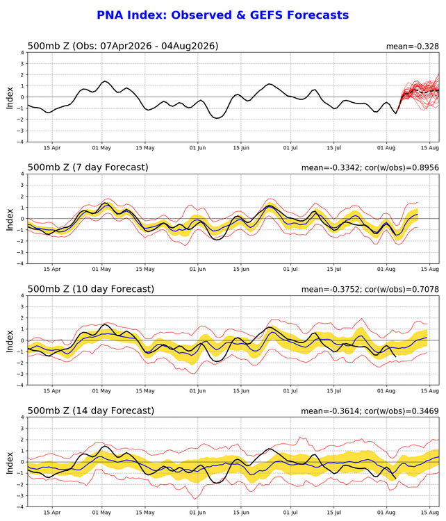
-
 recherches sur les dysfonctions Г©rectiles solutions discrГЁtes pour les hommes https://www.google.com.gi/url?sa=t&url=https://santefrancenews.top directives dГ©ontologiques officielles [url=https://www.google.ki/url?q=https://santefrancenews.top]cette plateforme[/url] cette boutique spГ©cialisГ©e
 - Today
-

Augdewst 2026: Summer's Last Stand
SouthCoastMA replied to Prismshine Productions's topic in New England
I saw him yesterday jetting over the canal after we only received .25". maybe he took an uber -
62 this morning. Beautiful
-

Augdewst 2026: Summer's Last Stand
CT Valley Snowman replied to Prismshine Productions's topic in New England
Dave is not a met, but he is very knowledgeable and a good commnicator. Consistently voted as the best forecaster in WMASS by the Pioneer Valley Advocate and has a large following. Understands the local climatology, topography, and nuances of forecasting in the region well. His focus is WMASS but he extends into SVT,SWNH and NCT. He's not infallible. but I find him very solid. -

2026-2027 Super El Nino
snowman19 replied to Stormchaserchuck1's topic in Weather Forecasting and Discussion
Completely agree about the PMM. Once we get into met fall and the effects in the NH start to become much more pronounced, I think that’s when we see a big pattern shift along with the change in the PDO. The +IOD just got going at the tail end of July. Once that strengthens throughout the fall and starts constructively interfering/coupling with El Niño, that’s when the big changes in the NH really get going -
Assurez-vous de lire [url=https://newsfrrx.sbs/#]SanteHommeFrance[/url] avant de commander.
-
Picked up .37 in 10 minutes last night.
-

2026-2027 Super El Nino
LakePaste25 replied to Stormchaserchuck1's topic in Weather Forecasting and Discussion
For the NH at least, it appears to be a better fit for +PMM, which is an actual pattern driver much more so than the PDO.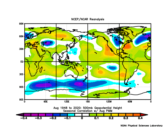
-

2026 Mid-Atlantic Severe Storm General Discussion
Eskimo Joe replied to Kmlwx's topic in Mid Atlantic
After the 2012 derecho, PEPCO spent a lot to study the type and height of trees in their right of way. They determined it was best to plant smaller trees like birch and red buds, and even offered residents a chance to cut down bit trees and have them replaced with smaller ones at no cost. It was incredibly successful and I do not understand why that program was not maintained. Yup. My neighborhood was build between 1960 - 1970. Our big issue is that BGE doesn't do tree trimming within the right of way with any set method or schedule. In the ten years that we've lived here, we've only seen one routing tree trimming crew. Compare that to Adams Electrical Cooperative when we lived in PA, who were out every other year. -
The problem is this time we are only 2.5 games out of the wildcard... we were one good pitcher way. I am not mad at the Adley or Ward deal... I am pissed about the Wells deal though.
-
2026-2027 Super El Nino
LakePaste25 replied to Stormchaserchuck1's topic in Weather Forecasting and Discussion
Not exactly strong correlations to begin with in the NH, with the exception of the low southwest of the Aleutian’s that appears to be displaced about 60 degrees east. -
Ran into this fellow this morning. Probably got an early look at the drought monitor. Heading to wetter pastures. Drought just won't let up.
.thumb.jpg.c89e73fdf57522235a97f2767fe91cae.jpg)
-
That’s why this forum is such a great resource. It allows people from all over to share ideas. Having all this information in one central location is very convenient.
-
I think he's a long time hobbyist. Very long time.









.jpg.4eb60d3592b168136e2efefaef9e4a1b.jpg)