All Activity
- Past hour
-
 If Chuck is right, I’m going to go all Allen Iverson up in here.
 -

Feb 10-11 Mid Week Minor Event - Ride the hot hand?
CoastalWx replied to HoarfrostHubb's topic in New England
Coastal Maine looks good. -
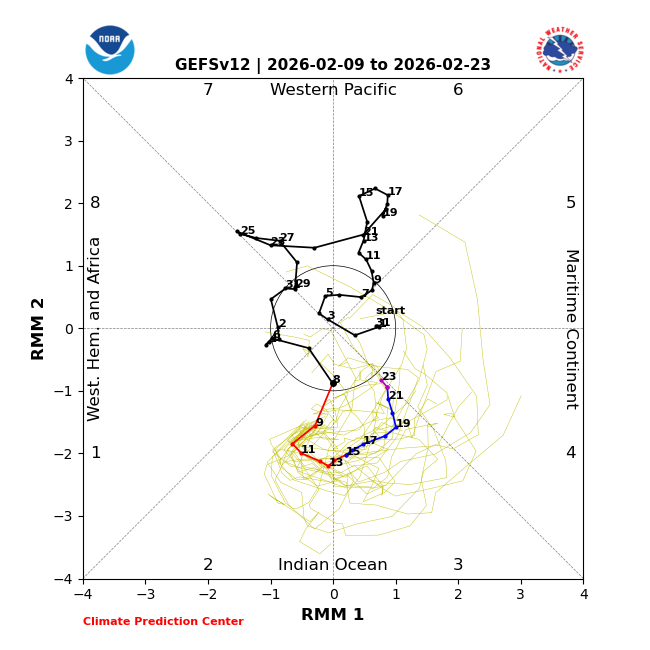
MJO....
-
Yeah that’s my point, it’s marginal if it does come. I look at that setup and jsut go blech. Not for me. Anyways, could be fun after the warm up.
-

E PA/NJ/DE Winter 2025-26 Obs/Discussion
Birds~69 replied to LVblizzard's topic in Philadelphia Region
Looks too warm from my eyes…. -

Feb 10-11 Mid Week Minor Event - Ride the hot hand?
dryslot replied to HoarfrostHubb's topic in New England
Been out of the loop and looked at a model for the first time in several days, Looks like accumulating snow with the clipper and wherever the trough sets up along the coast for tues night-weds, 3-5" first call. -
 Everything looks a bit warm for this weekend, EPS and GEFS both return us to near average or below average temps after a brief warm up so perhaps some more chances, but I'm getting that feeling like I'm almost ready for spring. One more window around Feb 20 then I'm rooting for 60 every day.
 -
9.3
-
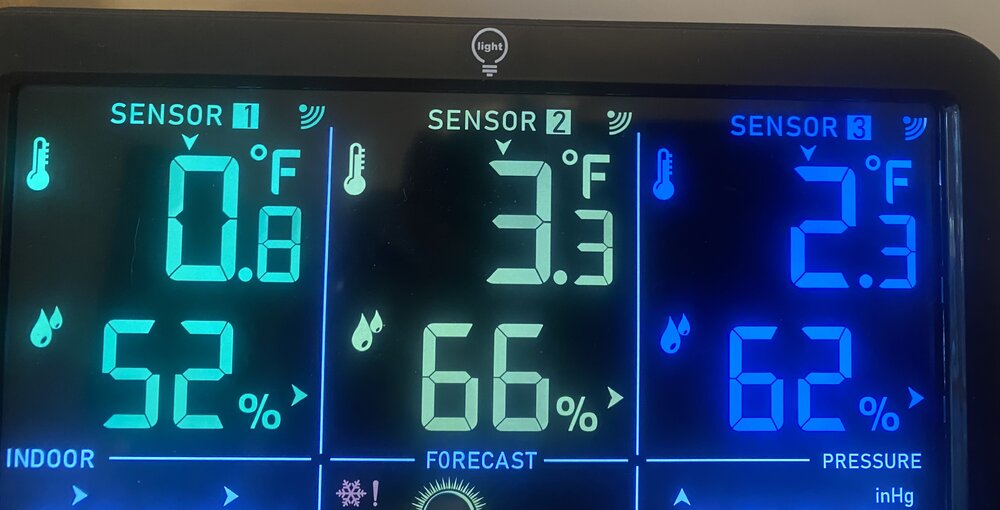
-6° for the low. Coldest night of the year for me
-

February 2026 OBS & Discussion
hudsonvalley21 replied to Stormlover74's topic in New York City Metro
-6 was the low here, currently-4. -
Only got down to 4, weird. The amount of debris wedged into my icefields….i mean front yard, is nuts.
-

Central PA Winter 25/26 Discussion and Obs
mahantango#1 replied to MAG5035's topic in Upstate New York/Pennsylvania
-
-6 was the low here. Currently-4
-
 Yeah, but still we’re about to exit the peak snow window for our regional climo. Sun angle season and all that.
 -
Feb 10-11 Mid Week Minor Event - Ride the hot hand?
CoastalWx replied to HoarfrostHubb's topic in New England
Not sure what to say. That’s not emotions, the the modeled setup. That’s for the other thread. -
Really cool to see all the young kids playing hockey on the ponds.
-

Feb 10-11 Mid Week Minor Event - Ride the hot hand?
dendrite replied to HoarfrostHubb's topic in New England
3k was pretty interesting for SW ME -

Pittsburgh/Western PA WINTER ‘25/‘26
RitualOfTheTrout replied to Burghblizz's topic in Upstate New York/Pennsylvania
Those are the key words. It looks likely we see some sort of storm somewhere in the east. The pattern is in transition this week though, so that's going to add even more uncertainty. Depending on timing and track, there may be enough residual cold and blocking left for snow. After the 15th though, I think we probably see a "real" thaw and stack at least a couple days above average in a row. -
If it's a real event, it's in a marginal atmosphere. About 15 or so years ago ... I began noticing that our "flop direction" is more wet than it used to be. We seemed to more and more so need a direct cold supply into/as a prerequisite, or systems tended to rain will less blue snow types ( winter). It's kind of dilemma, because if we do have the direct cold sourcing, the N/stream is active ...but the catch 22 there is that the flow is sped up and compressing, which is a canvas negative interference. I've been wondering since these models recently began to pull the N/stream away, if we might see this and there it is... The event profiles are going back to more marginal temperature. We snap back to a reality that we've been enabled for the past several months ... not to face. Also, this snow pack - at least around here ... - does not contain a huge load of water content. It's fluffy yet still since the bigger event on Jan 26. If we get a 40 F raining coastal followed by +2 850 mb during transition season solar irradiance on d-slope backside flow, we will be bear ground probably faster the some might think. Cross that bridge I guess... The GEFs aren't yet interested and keep thing progressive and weak through that period. It's coming from midland strength southern streamer coming through the SW. It's actually similar to what led the big even on Jan 26, only this time ...no N/stream. But it may not be coming from a very densely sampled atmosphere. Lot to consider -
-
Feb 10-11 Mid Week Minor Event - Ride the hot hand?
dendrite replied to HoarfrostHubb's topic in New England
You need ticks S. It’s a quick band of WAA precip down there and then slot before the CAA right now. -
I see Transylvania Co schools are out today because of snowfall from this morning? Thats wild, looks like a small bit of moisture worked in at like 4-5am.
-
Well that was a good run of cold temps, but sayonara, bon voyage, don’t forget to write. Let’s finish winter off more like Valdez instead of Fairbanks.
-
Richmond Metro/Hampton Roads Area Discussion
snowchill replied to RIC Airport's topic in Mid Atlantic
-

Feb 10-11 Mid Week Minor Event - Ride the hot hand?
Damage In Tolland replied to HoarfrostHubb's topic in New England
I didn’t say there was any that were heavy snow but there’s plenty of possibilities on the ensembles . Why not post that instead of emotional posts about rain and losing snow pack


