All Activity
- Past hour
-
Euro is a Mark MoreGarbage back broken to winter.
-

January 30th- Feb 1st ULL and coastal storm obs
donsutherland1 replied to JoshM's topic in Southeastern States
651 NOUS42 KILM 011754 PNSILM NCZ087-096-099-105>110-SCZ017-023-024-032-033-039-054>056-058-059-020554- Public Information Statement National Weather Service Wilmington NC 1254 PM EST Sun Feb 1 2026 ...SNOWFALL TOTALS FOR JANUARY 31 - FEBRUARY 1 WINTER STORM... Location Amount Time/Date Lat/Lon ...North Carolina... ...Bladen County... Bladenboro 9.0 in 0740 AM 02/01 34.54N/78.80W Jerome 6.0 in 1014 AM 02/01 34.83N/78.73W White Lake 6.0 in 0542 AM 02/01 34.64N/78.50W ...Brunswick County... Longwood 17.7 in 0730 AM 02/01 34.00N/78.55W Ocean Isle Beach 15.0 in 0540 AM 02/01 33.89N/78.43W 4 NE Calabash 14.6 in 0740 AM 02/01 33.94N/78.54W 2 NNE Calabash 13.8 in 0700 AM 02/01 33.92N/78.57W 1 NW Ocean Isle Beach 12.0 in 0443 AM 02/01 33.90N/78.45W 1 SW Holden Beach 10.0 in 0857 AM 02/01 33.91N/78.31W Bolivia 9.0 in 0859 AM 02/01 34.07N/78.15W Southport 9.0 in 0920 AM 02/01 33.93N/78.02W 4 ESE Supply 9.0 in 0800 AM 02/01 34.00N/78.21W Calabash 8.5 in 1000 AM 02/01 33.90N/78.58W 2 NE Oak Island 8.1 in 0700 AM 02/01 33.94N/78.14W Boiling Spring Lake 8.0 in 0855 AM 02/01 34.03N/78.07W 1 N Calabash 8.0 in 0856 AM 02/01 33.91N/78.58W Oak Island 8.0 in 0857 AM 02/01 33.92N/78.17W 3 N Varnamtown 8.0 in 0739 AM 02/01 33.98N/78.24W Shallotte 7.5 in 0931 AM 02/01 33.98N/78.39W 2 WNW Calabash 7.4 in 0700 AM 02/01 33.91N/78.61W Leland 7.0 in 0700 AM 02/01 34.24N/78.01W Winnabow 7.0 in 0730 AM 02/01 34.15N/78.10W 1 NE Southport 6.5 in 0700 AM 02/01 33.93N/78.01W 4 SSW Belville 6.0 in 0923 AM 02/01 34.18N/78.00W ...Columbus County... Tabor City 16.0 in 0900 AM 02/01 34.15N/78.87W Cerro Gordo 14.0 in 0557 AM 02/01 34.32N/78.93W Evergreen 12.0 in 0745 AM 02/01 34.42N/78.90W Nakina 11.0 in 1000 AM 02/01 34.13N/78.67W Chadbourn 10.0 in 0850 AM 02/01 34.32N/78.83W 2 N Whiteville 9.0 in 0800 AM 02/01 34.37N/78.71W ...New Hanover County... 1 WNW Seagate 9.5 in 0943 AM 02/01 34.21N/77.86W 1 N Carolina Beach 9.0 in 0910 AM 02/01 34.05N/77.90W 3 N Carolina Beach 9.0 in 1020 AM 02/01 34.08N/77.89W 1 ENE Bayshore 8.5 in 0910 AM 02/01 34.29N/77.77W 2 NE Windemere 8.5 in 1000 AM 02/01 34.26N/77.83W Bayshore 8.0 in 0718 AM 02/01 34.29N/77.79W Masonboro 7.6 in 0700 AM 02/01 34.17N/77.87W 1 NW Silver Lake 7.6 in 0807 AM 02/01 34.16N/77.93W 1 NNE Myrtle Grove 6.6 in 1000 AM 02/01 34.14N/77.87W 1 NE Bayshore 6.0 in 0900 AM 02/01 34.30N/77.78W Myrtle Grove 6.0 in 0854 AM 02/01 34.12N/77.89W Wrightsville Beach 6.0 in 0700 AM 02/01 34.21N/77.79W Wilmington 5.8 in 0800 AM 02/01 34.21N/77.91W 2 SSW Wilmington 5.5 in 0639 AM 02/01 34.19N/77.92W ...Pender County... 2 SW Maple Hill 12.5 in 0611 AM 02/01 34.65N/77.75W 2 NNW Hampstead 12.0 in 0430 AM 02/01 34.40N/77.71W 6 E Saint Helena 10.0 in 0800 AM 02/01 34.52N/77.81W Surf City 10.0 in 0500 AM 02/01 34.42N/77.56W Watha 9.2 in 0800 AM 02/01 34.64N/77.96W Burgaw 7.0 in 0930 AM 02/01 34.55N/77.93W 3 SSW Watha 6.5 in 0730 AM 02/01 34.60N/77.98W 3 NW Castle Hayne 5.1 in 0700 AM 02/01 34.38N/77.93W ...Robeson County... Fairmont 12.7 in 0700 AM 02/01 34.50N/79.12W 1 WSW Lumberton 10.0 in 0740 AM 02/01 34.63N/79.03W 1 WSW Lumberton 10.0 in 0741 AM 02/01 34.63N/79.02W 5 S Orrum 9.6 in 0830 AM 02/01 34.39N/79.00W Parkton 4.5 in 0830 AM 02/01 34.90N/79.01W ...South Carolina... ...Darlington County... 2 NE Clyde 6.0 in 0700 AM 02/01 34.40N/80.16W 5 NNE Timmonsville 5.0 in 0850 AM 02/01 34.21N/79.91W ...Dillon County... Lake View 12.0 in 0551 AM 02/01 34.34N/79.17W 2 ENE Dillon 9.2 in 0700 AM 02/01 34.43N/79.33W 1 SSW Little Rock 8.0 in 0700 AM 02/01 34.46N/79.41W ...Florence County... Florence 6.0 in 0545 AM 02/01 34.18N/79.78W Scranton 5.5 in 0700 AM 02/01 33.92N/79.74W 2 WSW Effingham 3.5 in 0500 AM 02/01 34.06N/79.79W ...Georgetown County... Pawleys Island 2.0 in 0820 AM 02/01 33.42N/79.13W 5 NNE Georgetown 1.4 in 0800 AM 02/01 33.43N/79.25W ...Horry County... 2 ENE Little River 8.0 in 1129 AM 02/01 33.89N/78.60W North Myrtle Beach 8.0 in 0548 AM 02/01 33.83N/78.67W Longs 7.7 in 0900 AM 02/01 33.93N/78.73W Aynor 7.5 in 1148 AM 02/01 34.00N/79.20W Bayboro 7.0 in 0900 AM 02/01 34.02N/79.02W Socastee 6.0 in 0850 AM 02/01 33.69N/79.01W 3 SE Longs 5.3 in 0700 AM 02/01 33.89N/78.69W Myrtle Beach 5.0 in 0700 AM 02/01 33.70N/78.89W 3 SSW Socastee 4.5 in 0800 AM 02/01 33.64N/79.03W 3 S Red Hill 2.9 in 0700 AM 02/01 33.75N/79.02W ...Marion County... 1 SSE Mullins 8.0 in 0740 AM 02/01 34.19N/79.25W Marion 5.0 in 0940 AM 02/01 34.18N/79.40W ...Marlboro County... Wallace 6.0 in 0109 AM 02/01 34.72N/79.84W && -
January 30th- Feb 1st ULL and coastal storm obs
donsutherland1 replied to JoshM's topic in Southeastern States
083 NOUS42 KMHX 011814 PNSMHX NCZ029-044>047-079>081-090>092-094-193>196-198-199-203>205-020614- Public Information Statement National Weather Service Newport/Morehead City NC 114 PM EST Sun Feb 1 2026 ...Total SNOWFALL REPORTS Through Noon... Location Amount Time/Date Provider ...North Carolina... ...Beaufort County... 1 ESE Bath 17.0 in 1043 AM 02/01 Public 1 ESE Bayview 15.0 in 0947 AM 02/01 Public 3 S Old Ford 13.5 in 1015 AM 02/01 Public 3 E Belhaven 13.0 in 0939 AM 02/01 Public 1 NNW Belhaven 13.0 in 0947 AM 02/01 Public 4 N Cox Crossing 13.0 in 1133 AM 02/01 Public 2 SW Long Acre VFD 11.9 in 0900 AM 02/01 Trained Spotter 1 SW Washington 11.0 in 0850 AM 02/01 Public 3 SSE Blounts Creek 11.0 in 0943 AM 02/01 Public 5 SW Aurora 11.0 in 1000 AM 02/01 Fire Dept/Rescue ...Carteret County... 1 SE Peletier 19.5 in 1004 AM 02/01 Public Cedar Point 0.9 WSW 16.0 in 0500 AM 02/01 COCORAHS 2 ENE Broad Creek 16.0 in 0631 AM 02/01 Public 1 SW Newport 15.2 in 0700 AM 02/01 Official NWS Obs Otway 15.0 in 0827 AM 02/01 Public 1 WSW Broad Creek 15.0 in 0900 AM 02/01 NWS Employee Beaufort 15.0 in 0900 AM 02/01 Public 2 SSE Newport 14.5 in 0944 AM 02/01 Public 2 ESE Stella 14.2 in 1140 AM 02/01 NWS Employee 2 E Stella 14.0 in 1055 AM 02/01 Public 1 WNW Harkers Island 14.0 in 1123 AM 02/01 Public 1 SSE North River 14.0 in 1140 AM 02/01 Public Cape Carteret 1.5 NE 13.6 in 0700 AM 02/01 COOP Morehead City 13.0 in 0456 AM 02/01 Public Morehead City 2.9 WNW 13.0 in 0750 AM 02/01 COCORAHS 1 S Otway 13.0 in 0923 AM 02/01 Public 1 E Harkers Island 13.0 in 1020 AM 02/01 Trained Spotter Morehead City 5.7 W 12.5 in 0700 AM 02/01 COCORAHS Emerald Isle 2.1 E 10.0 in 0700 AM 02/01 COCORAHS 1 W Mitchell Village 10.0 in 0800 AM 02/01 Trained Spotter 1 W North River 10.0 in 0845 AM 02/01 NWS Employee Beaufort 3.8 N 8.5 in 0700 AM 02/01 COCORAHS ...Craven County... James City 2.5 S 18.0 in 0700 AM 02/01 COCORAHS 4 E James City 17.5 in 1104 AM 02/01 Public New Bern 7.3 ESE 17.0 in 0730 AM 02/01 COCORAHS 5 SSE Minnesott Beach 16.0 in 1049 AM 02/01 Public Trent Woods 1.2 ENE 15.5 in 0600 AM 02/01 COCORAHS 1 S New Bern 15.0 in 0918 AM 02/01 Public Bridgeton 14.2 in 0909 AM 02/01 Trained Spotter 1 ENE Trent Woods 14.0 in 0629 AM 02/01 Public 3 NNW Riverdale 14.0 in 0804 AM 02/01 Public Vanceboro 14.0 in 1120 AM 02/01 Public 1 SE Riverdale 13.5 in 0952 AM 02/01 Public 2 NNW Riverdale 13.5 in 1050 AM 02/01 Public New Bern 1.3 NNE 13.0 in 0700 AM 02/01 COCORAHS Trent Woods 1.3 WNW 13.0 in 0725 AM 02/01 COCORAHS 1 WNW Coastal Carolina Regio 12.5 in 0700 AM 02/01 COCORAHS Havelock 1.9 SSE 12.2 in 0800 AM 02/01 COCORAHS ...Dare County... 1 SSW Southern Shores 11.0 in 0730 AM 02/01 COCORAHS Duck 7.0 in 0730 AM 02/01 Trained Spotter 1 SSE Wright Brothers Nation 6.0 in 0929 AM 02/01 Trained Spotter Wanchese 2.8 in 0730 AM 02/01 COCORAHS Frisco 2.0 in 1140 AM 02/01 Public ...Duplin County... Beulaville 13.0 in 0700 AM 02/01 Broadcast Media Potters Hill 12.0 in 0823 AM 02/01 Public 1 WNW Albertson 12.0 in 0925 AM 02/01 Broadcast Media Potters Hill 12.0 in 0942 AM 02/01 Trained Spotter Wallace 14.8 E 11.0 in 0700 AM 02/01 COCORAHS Faison 3.3 SSE 11.0 in 0900 AM 02/01 COCORAHS 1 E Rose Hill 10.0 in 1044 AM 02/01 Public Rose Hill 10.0 in 1135 AM 02/01 Public Magnolia 7.0 in 0715 AM 02/01 Trained Spotter ...Hyde County... Scranton 5.6 SW 12.0 in 0700 AM 02/01 COCORAHS Sladesville 12.0 in 0957 AM 02/01 Trained Spotter Ocracoke 0.2 ESE 3.0 in 0800 AM 02/01 COCORAHS ...Jones County... Trenton 16.5 in 0706 AM 02/01 Public Trenton 15.0 in 0839 AM 02/01 Broadcast Media Wise Forks 13.0 in 0930 AM 02/01 Public ...Lenoir County... Pink Hill 16.0 in 0648 AM 02/01 Public Kinston 5.1 WNW 15.0 in 0700 AM 02/01 COCORAHS Kinston 14.0 in 0703 AM 02/01 Trained Spotter 4 ENE Sandy Bottom 13.5 in 0728 AM 02/01 Trained Spotter 1 NE Kinston 13.0 in 0820 AM 02/01 Kinston 4.6 ESE 11.5 in 0700 AM 02/01 COCORAHS La Grange 5.5 NE 10.5 in 0720 AM 02/01 COCORAHS Pink Hill 2.5 NE 10.0 in 0810 AM 02/01 COCORAHS ...Martin County... 3 W Williamston 13.0 in 0951 AM 02/01 Public Williamston 9.5 in 0741 AM 02/01 Public Williamston 8.9 SSE 6.5 in 0741 AM 02/01 COCORAHS ...Onslow County... Swansboro 17.0 in 0718 AM 02/01 Public 2 NW Hammocks Beach State Pa 16.0 in 0730 AM 02/01 Public 3 S Silverdale 16.0 in 0900 AM 02/01 NWS Employee Half Moon 14.0 in 0922 AM 02/01 Public 1 SSW Holly Ridge 13.0 in 0646 AM 02/01 Public 2 NW Midway Park 13.0 in 0720 AM 02/01 Public Jacksonville 3.3 W 13.0 in 0800 AM 02/01 COCORAHS 3 NW Half Moon 13.0 in 1021 AM 02/01 Public 1 S Camp Lejeune Center 13.0 in 1121 AM 02/01 Public Holly Ridge 3.7 E 12.5 in 0700 AM 02/01 COCORAHS Richlands 12.5 in 1119 AM 02/01 Public 4 SE Cypress Creek 12.5 in 1201 PM 02/01 Trained Spotter 2 SE Jacksonville 12.3 in 0630 AM 02/01 Trained Spotter 2 SSE Pumpkin Center 12.0 in 0907 AM 02/01 Trained Spotter Kellum 11.0 in 0700 AM 02/01 Trained Spotter ...Pamlico County... Reelsboro 19.0 in 0727 AM 02/01 Public Grantsboro 18.0 in 0639 AM 02/01 Public 1 SE Minnesott Beach 17.0 in 0631 AM 02/01 Public Bayboro 14.0 in 0728 AM 02/01 Public Bayboro 3 SW 13.0 in 0700 AM 02/01 COOP Merritt 1.5 WSW 13.0 in 0700 AM 02/01 COCORAHS ...Pitt County... 4 WSW Greenville 15.0 in 0830 AM 02/01 Public 4 WNW Falkland 14.0 in 0956 AM 02/01 Trained Spotter Grifton 13.5 in 0923 AM 02/01 Public 1 W Shelmerdine 12.5 in 0730 AM 02/01 Public 1 SE Winterville 12.2 in 0900 AM 02/01 Public 1 SE Winterville 12.1 in 0921 AM 02/01 Public Greenville 5.7 NW 12.0 in 0700 AM 02/01 COCORAHS 1 S Dowdy Ficklen Stadium 12.0 in 0729 AM 02/01 Public Farmville 0.8 ESE 11.7 in 0700 AM 02/01 COCORAHS 1 NNE Bell Arthur 11.5 in 0755 AM 02/01 Public 1 N Ayden 11.0 in 0912 AM 02/01 Greenville 5.0 SE 10.5 in 0800 AM 02/01 COCORAHS 2 N Winterville 10.0 in 1031 AM 02/01 Public 4 SE Winterville 9.0 in 0914 AM 02/01 Public 2 NNE Winterville 7.5 in 1025 AM 02/01 Trained Spotter ...Tyrrell County... Gum Neck (COOP) 16.1 in 0700 AM 02/01 COOP Columbia 4.9 W 11.0 in 0700 AM 02/01 COCORAHS 1 NNW Alligator 10.0 in 0554 AM 02/01 Public && -
I'm tired of cold.
-
Bears watching. I wouldn't buy into the mainly Rain Depiction most our spitting out. Thermals mighty close. Euro and RGEM may score again here.
-
Can we also start a Friday thread. We’re going to get hammered with .5”
-
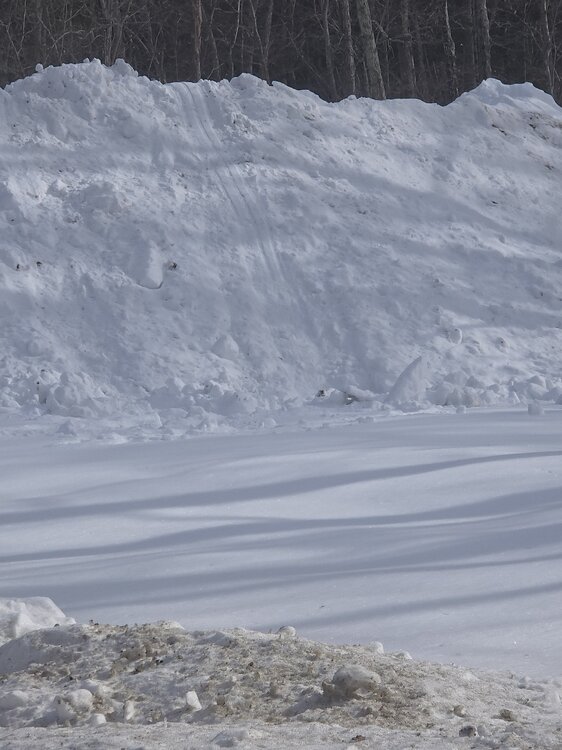
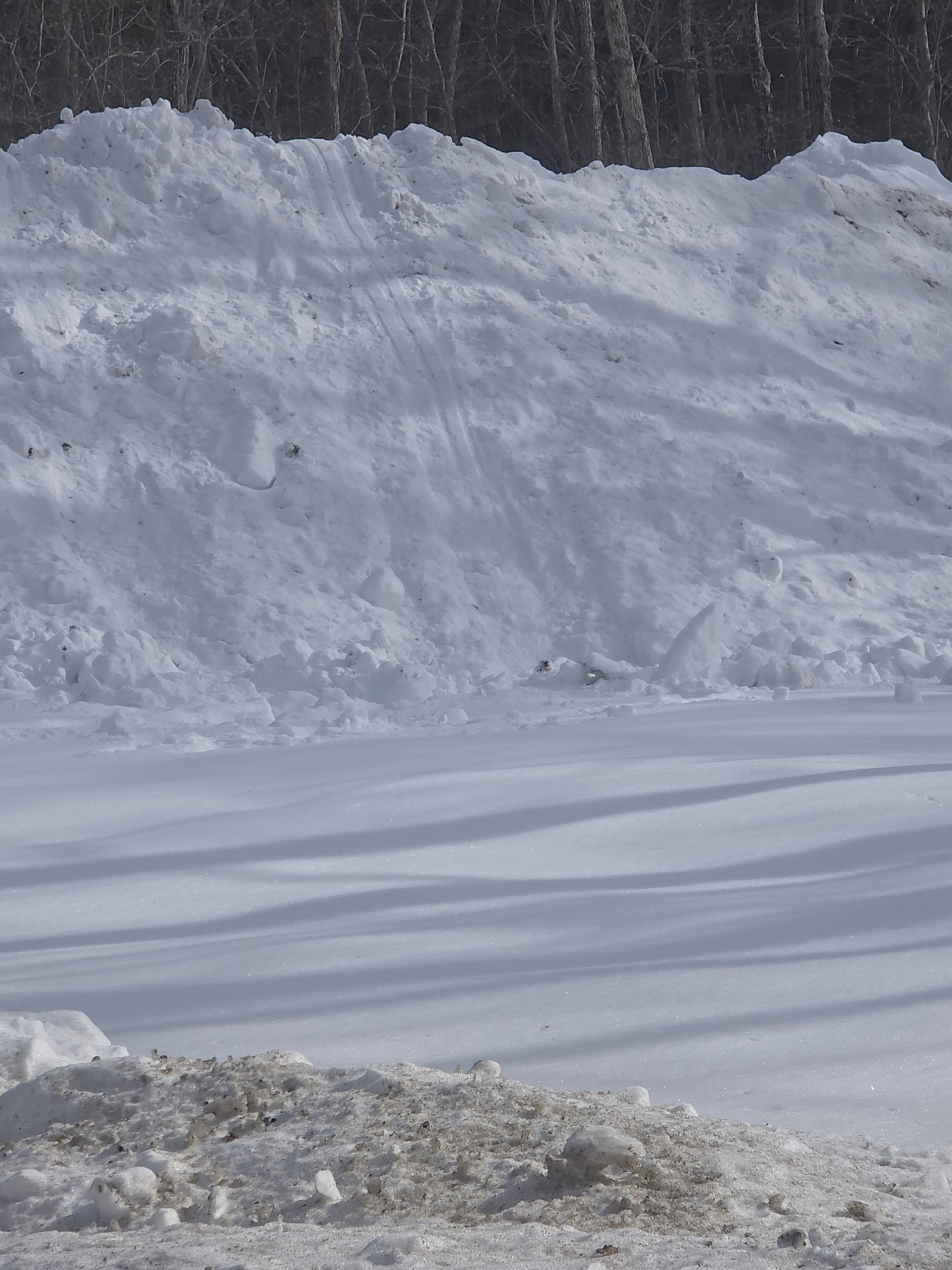
Neighbors kids made good out of the driveway piles.
-
Euro close to that. Wouldn't surprise me at all.
-
I'll take this sunny/frigid weather any day over 35 and overcast. If you can stay out of the wind, the sun feels great. Feels like a true winter.
-
Oh I know what you were saying. But the complaining around Lewisville on FB and otherwise is entertaining (sometimes depressing). Do they not teach that ice does not melt until it reaches 32 degrees anymore? People don't seem to trust that science or understand it.
-

January 30th- Feb 1st ULL and coastal storm obs
Stebaney replied to JoshM's topic in Southeastern States
Knightdale ended up with 6” imby.
-
JenkinsJinxie?
-
https://pickerwheel.com/?id=wNm5D
-

Possible coastal storm centered on Feb 1 2026.
amarshall replied to Typhoon Tip's topic in New England
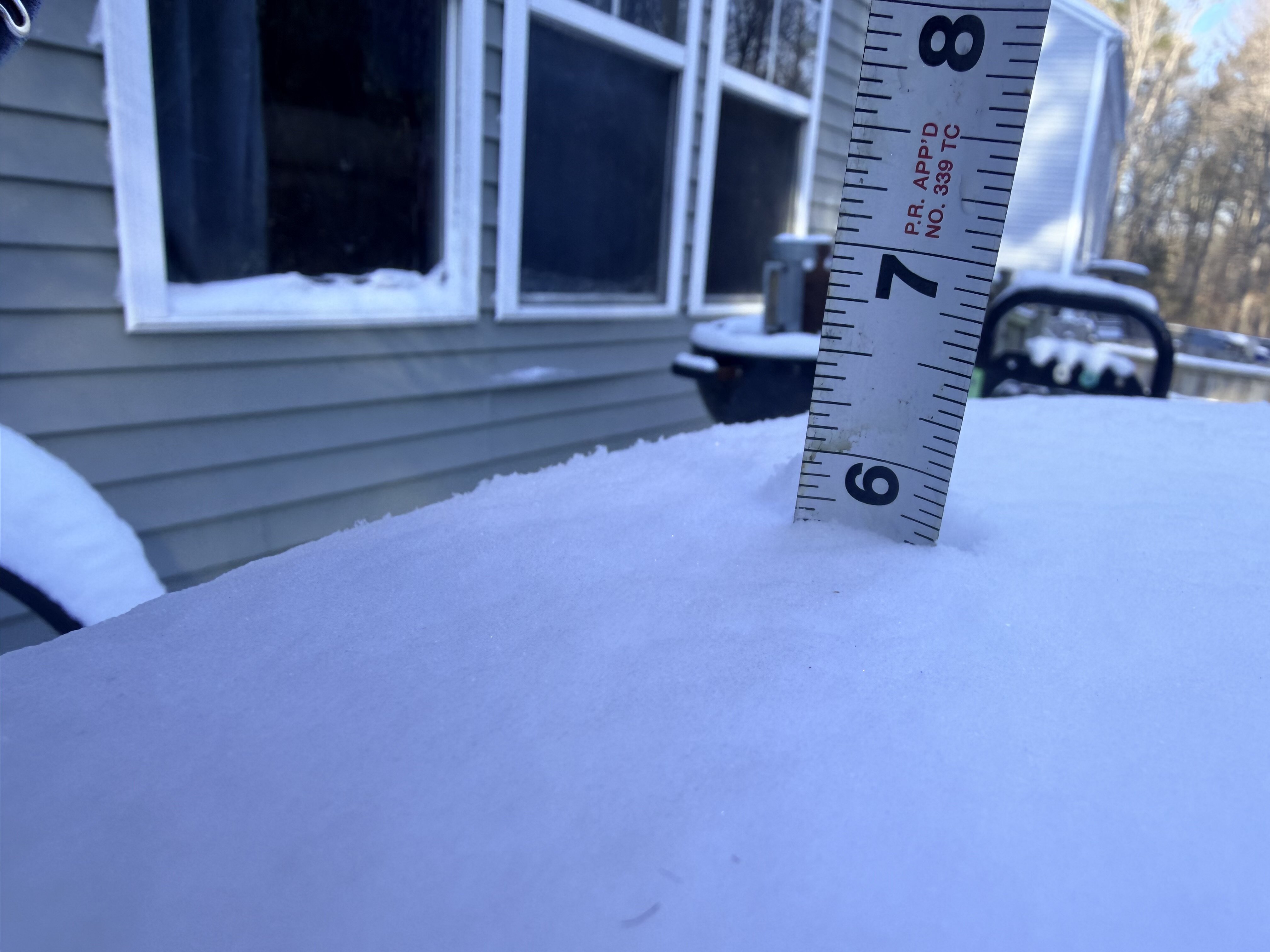
2" fluff Duxbury. Nice refresher . -
Thanks for the info! I was assuming that the ULL was acting like the primary low of a Miller B and that the low of the coast was the secondary. I guess that is not the case? Were the ULL and coastal low just coincidental to each other?
-
It's a widespread dusting to a half inch. Read the thread title- A weak ass mutha fucking POS. Don't come in here expecting more than an inch, because the shitty GFS depicts it lol.
-
Last night Orlando FLA saw temps fall to 27°F, while Juneau was @ 33°F, parts of southeastern U.S. was colder than parts of Southeast Alaska.
-
Agree Steve. Looking pretty decent going forward…we’ll have quite a few chances this second half. Not every one will hit. Or will be good for everybody, but we’ll have opportunities. All you can ask for. No complaints here so far.
-
Exactly. This is a no Fs to give event. Lighthearted entertainment. Thread in right spirit, lfg
-
I noticed the Wilmington NC area was dry slotting yesterday. Oh, the pain...
-
Interesting. I'd be curious to know how the latest warm season water temp ranked. Was the starting point significantly higher this cold season, coming off the dry and sunny August/Sept? If so, does that even matter (you'd think a persistent NW flow generates more mixing snd upwelling)?
-
Title is LOL.
-
-
Possible coastal storm centered on Feb 1 2026.
rnaude241 replied to Typhoon Tip's topic in New England
2 fluffy inches so far in Plymouth. Coming down decently. -
Man I feel bad for the plains westward; total dud winter for them.


.thumb.jpeg.f5c6ba9d911ec96b3b124f8606aee58e.jpeg)