All Activity
- Past hour
-
May 18 1980: Mt. St. Helens erupts. The smoke plume eventually rises to 80,000 feet, circling the earth in 19 days. Brilliant sunsets due to the smoke are seen over Minnesota for days afterward. 1933: Tornadoes hit McLeod and Mower counties. For Monday, May 18, 2026 1825 - A tornado said to have crossed all of the state of Ohio smashed into the log cabin settlement of Burlington, northeast of Columbus. (David Ludlum) 1960 - Salt Lake City UT received an inch of snow. It marked their latest measurable snowfall of record. (The Weather Channel) 1980 - Mount Saint Helens in Washington State erupted spewing ash and smoke sixty-three thousand feet into the air. Heavy ash covered the ground to the immediate northwest, and small particles were carried to the Atlantic coast. (David Ludlum) 1987 - Thunderstorms in Kansas, developing along a cold front, spawned tornadoes at Emporia and Toledo, produced wind gusts to 65 mph at Fort Scott, and produced golf ball size hail in the Kansas City area. Unseasonably hot weather prevailed ahead of the cold front. Pomona NJ reported a record high of 93 degrees, and Altus, OK, hit 100 degrees. (The National Weather Summary) (Storm Data) 1988 - Low pressure anchored over eastern Virginia kept showers and thunderstorms over the Middle Atlantic Coast Region. Flash flooding was reported in Pennsylvania. Up to five inches of rain drenched Franklin County PA in 24 hours. (The National Weather Summary) 1989 - Thunderstorms developing ahead of a cold front produced severe weather from the Central Gulf Coast States to the Lower Missouri Valley during the day and evening. Thunderstorms spawned sixteen tornadoes, and there were 74 reports of large hail and damaging winds. (The National Weather Summary) (Storm Data) 1990 - Thunderstorms produced severe weather in the central U.S. spawning a sixteen tornadoes, including a dozen in Nebraska. Thunderstorms also produced hail four inches in diameter at Perryton TX, wind gusts to 84 mph at Ellis KS, and high winds which caused nearly two million dollars damage at Sutherland NE. Thunderstorms deluged Sioux City IA with up to eight inches of rain, resulting in a record flood crest on Perry Creek and at least 4.5 million dollars damage. (The National Weather Summary) (Storm Data)
-
par for the course. also makes me wonder if the weekend ends up drier
-
snow reported at the cities in central/southern Wyoming and also here at RMNP:
-
Looking at NYC and other (somewhat shorter record) sites, I'd put the mid-60s as the driest in a century or more.
-
Ho man. The wonder of weather, snuffed out. we joke but there will be a weather modification future. It's just too intuitively easy to see that. Quantum Computing is basically going to expose at some point, how to force "the quantum computing of the cosmos" - so to speak. That is, in any future where human tech does not stop the the future from taking place before getting there - oh yeah..that. I mean just recall synoptic II and learning how/why chaos will never allow modeling to be very precise beyond whenever. Can't stop the spontaneity of emerging future feedbacks blah blah the prediction unavoidably corrupted. Well, the easy antidote is ...don't try to predict that then. Control it. It seems quantum scale perturbation is a realm where actual Quantum Computing might be uniquely situated to control. Seems that way anywho
-
0.19" of rain last night. Very meager from what was expected. Cool, drizzly, foggy morning. Fire is 62% contained with 34 structures destroyed. Should be about done by tomorrow.
-
Is the severe threat for late Tuesday and Wednesday not worth mentioning?
-
(002).thumb.png.6e3d9d46bca5fe41aab7a74871dd8af8.png)
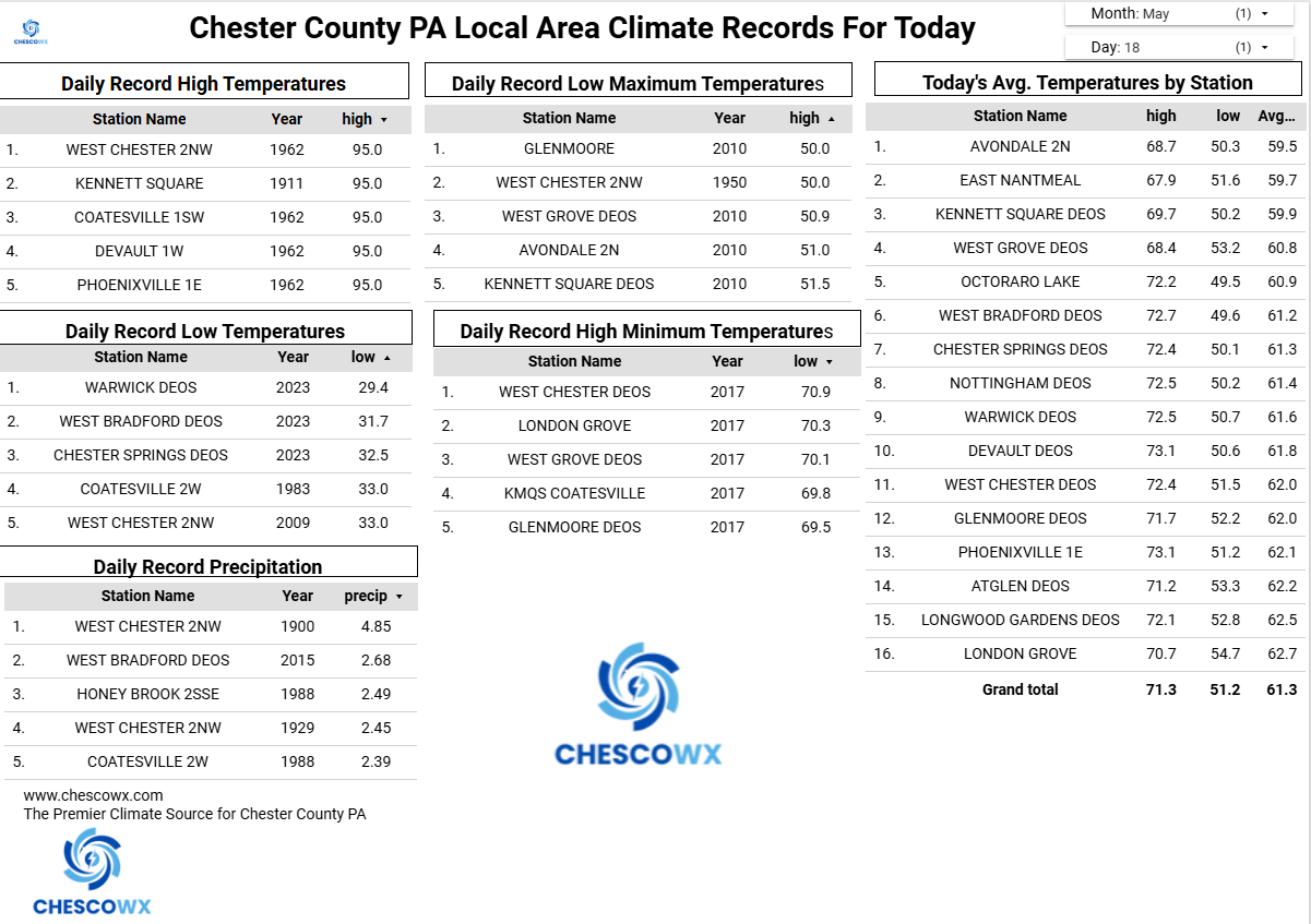
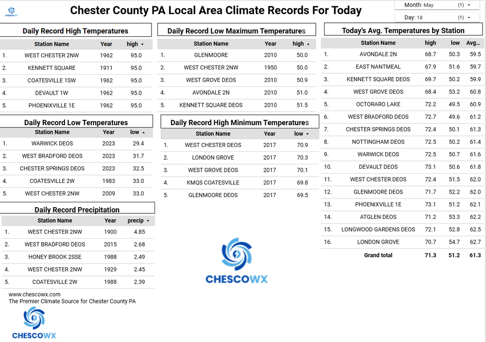
Central PA Spring 2026 Discussion/Obs Thread
ChescoWx replied to Voyager's topic in Upstate New York/Pennsylvania
A hot start to the week with our warmest day tomorrow before a sharp chill down by Memorial Day weekend. Many valley locations could touch 90 degrees both today and for sure tomorrow. Some higher ridges may fall a bit short of 90 both days. By Thursday temperatures should be at least 20 degrees cooler than Wednesday. In fact, while the current NWS forecast has highs in the mid 60's both Friday and Saturday I suspect much of Chester County will struggle to get out of the chilly 50's both Friday and Saturday. Shower chances increase on Wednesday with shower chances continuing through the weekend.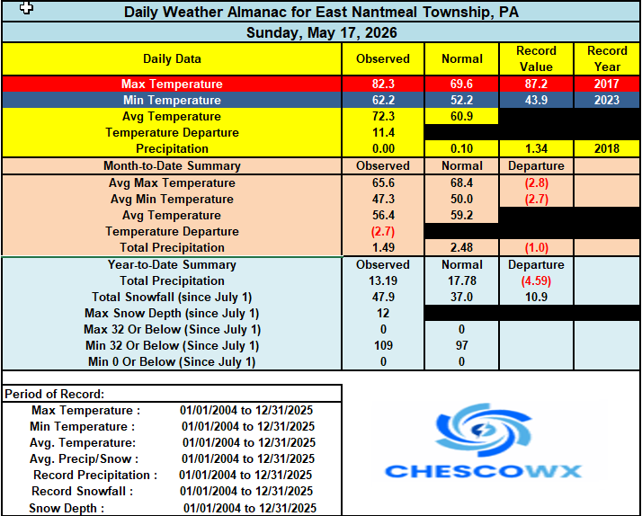
-
E PA/NJ/DE Spring 2026 Obs/Discussion
ChescoWx replied to PhiEaglesfan712's topic in Philadelphia Region
A hot start to the week with our warmest day tomorrow before a sharp chill down by Memorial Day weekend. Many valley locations could touch 90 degrees both today and for sure tomorrow. Some higher ridges may fall a bit short of 90 both days. By Thursday temperatures should be at least 20 degrees cooler than Wednesday. In fact, while the current NWS forecast has highs in the mid 60's both Friday and Saturday I suspect much of Chester County will struggle to get out of the chilly 50's both Friday and Saturday. Shower chances increase on Wednesday with shower chances continuing through the weekend.
-

2026-2027 Strong/Super El Nino
PhiEaglesfan712 replied to Stormchaserchuck1's topic in Weather Forecasting and Discussion
Yeah, that 2018-20 period was a disjointed at best. We didn't really have a definitive ENSO or PDO state during those years (the PDO was near neutral for the greater part of almost 4 years after the mid-2010s el nino dissipated), until we got to 2020-21, which was a solid la nina and -PDO. -
60° every Christmas morning for safe travel!
-
Already 74° with a projected high of 74.
-
Central MD special Now if only I trusted the RGEM at this range more.
-
Wednesday's front not looking like it will have much rain with it
-
i’ll take whatever rain we can get whenever we can get it at this point
-
It's like a yearly tradition. But it is still May and Memorial day is early this year.
-
It isn’t going to happen, but the Euro and HRRR have DC at 100 on Tuesday.
-
About as many times as it actually happens j/k. yeah who knows. There's nothing wrong with commiserating the modles
-
...that'd be an interesting war -tech. Imagine a distant future world where weather modification replaced forecasting. Other than ruining this pastime ... maybe such a realm would include the WMD, Weather Machine of Destruction that throws big storm bombs at enemies. I dunno, where the hell is the end goal of Quantum Computing and what does that look like?
-
How many times do we see this ? People freak and wring hands in consternation over a rainy weekend 5 days out and come verification time it’s one day or part of a day wet and the rest of the time is fine . And then you see posts like .. well this wasn’t bad at all … where’s the rainy weekend etc . Same will happen with MDW
-
Since Sunday afternoon thru overnight I have picked up 0.59”. About half of that from thunderstorms yesterday, and the rest thru snow showers early this morning. The temp is 35 degrees, and it will be interesting to see whether we get to the 4-5” of accumulation today. Regardless, it is good moisture.
-
Got another 0.47" overnight into this morning, so at least we are getting something from each round. My weekend total is 1.22". Models are still suggesting almost everything will be down in Missouri later today.
-
Yeah, that EC-AIFS frontal stall isn’t pretty. Let’s hope the front at least clears the area by Memorial Day. But the slow moving front and easterly winds signal is there for rain at least one day out of the three from Saturday to Monday.
-
Not that you asked 'how' but what's happening in those guidance formulations is something more akin to the 00z GFS' aggressively suppressed version overall. BN, but dry results. Which ...I'd take that as a compromise over a wet dildo flogging as though the Canadian and European forecast offices conspired and directly parameterized their models to specifically target and destroy Mem Weekend for joy destruction. haha I guess for now... solace in the notion that it's 120+ hours away so maybe the shits models runs'll change.
-

Central PA Spring 2026 Discussion/Obs Thread
Mount Joy Snowman replied to Voyager's topic in Upstate New York/Pennsylvania
Low of 63. Record highs for the next three days are 94/95/94, wonder if we can challenge any of 'em. In any case, we should more than erase our -3 degree monthly departure. Baseball practice for 4-6 year olds should be fun tonight ha. Onward.