All Activity
- Past hour
-
I havent been over here in years. No wonder why you have such a range of temps, forgot how much the elevation changes in short distances over here. Sorry in advance about your kitchen window, i tend to slice the ball. Lol
-
Hey there! Long time no chat, shame! Although I think my wife and your SO still follow each other on instagram . Congrats on the new-ish position! I've been pulling out my hair for the past 2 years getting this network up and running, although I think @Eskimo Joe beats me in sleep lost. We're working on the datafeeds! We're currently in the process of hiring a developer to create / manage some of that stuff. Congrats on the break-up though! I think you all will do well. Happy to work on a piece if Jason is up for it.
-
That had been us last year. I am not counting my chickens before they hatch just yet up here though. Last summer July and August was bone dry. So will take what I can get now. We love having ours. Have been up since 2013. We just added an EV to the car line up. Put in a portable charger and utilizing the sun to “fill” it up is a good bit of satisfaction.
-

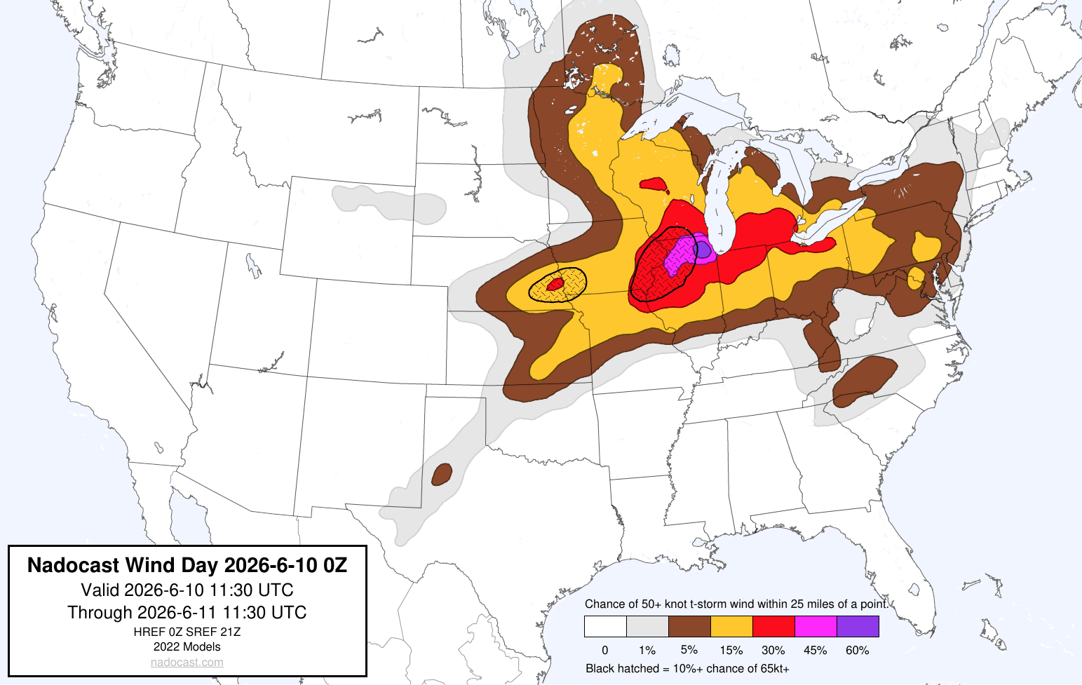
2026 Mid-Atlantic Severe Storm General Discussion
Eskimo Joe replied to Kmlwx's topic in Mid Atlantic
Saw that. Looks like some summer showers and storms. Would be very beneficial. -
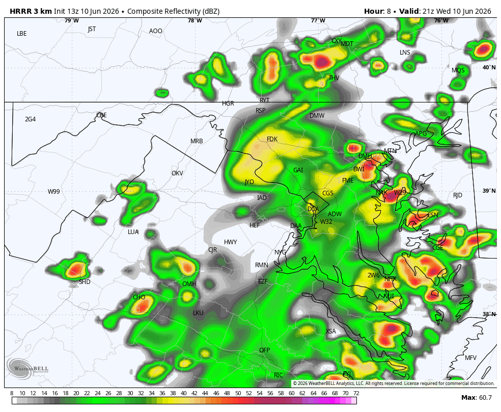
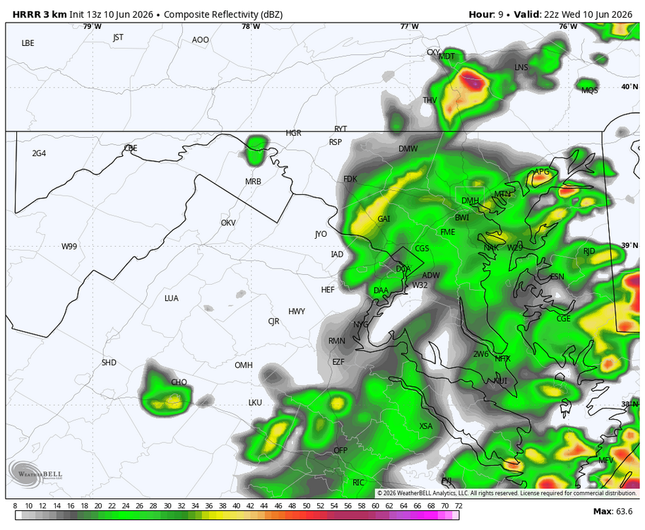
HRRR actually has something coming through Central Maryland this afternoon.
-
A soupy 72.8/69.9 here with rain falling. Decent thunderstorm moving thru, only a 28 mph gust, but will take ALL the rain that wants to fall! About .30" in 25-30 minutes.
-

-
2026 Mid-Atlantic Severe Storm General Discussion
Eskimo Joe replied to Kmlwx's topic in Mid Atlantic
Nice little swirl over West Virginia. If we can get enough sunshine today, we might get some decent storms south of I-70. Might be a DC to EZF special. -
2026 Mid-Atlantic Severe Storm General Discussion
Eskimo Joe replied to Kmlwx's topic in Mid Atlantic
Got a graphic? -

2026-2027 Super El Nino
snowman19 replied to Stormchaserchuck1's topic in Weather Forecasting and Discussion
100%. 1997-98 peaked the final week of November then steadily weakened right through the end of March. 2015 also peaked the last week of November then steadily weakened throughout the entire winter. Twitter kept wishcasting that the weakening was going to somehow “save” that winter and it was going to turn into an arctic cold tundra with mountains of snow the rest of the way. It also didn’t help that JB was hyping nonstop that it was a super “migrating Modoki” El Niño and said the analogs were 1957-58, 1965-66, 1976-77, 1977-78, 2002-03, 2009-10 and 2014-15 for months on end in the fall and beginning of winter. The weenies bought right into that and the DT “it’s weakening” argument hook, line and sinker -
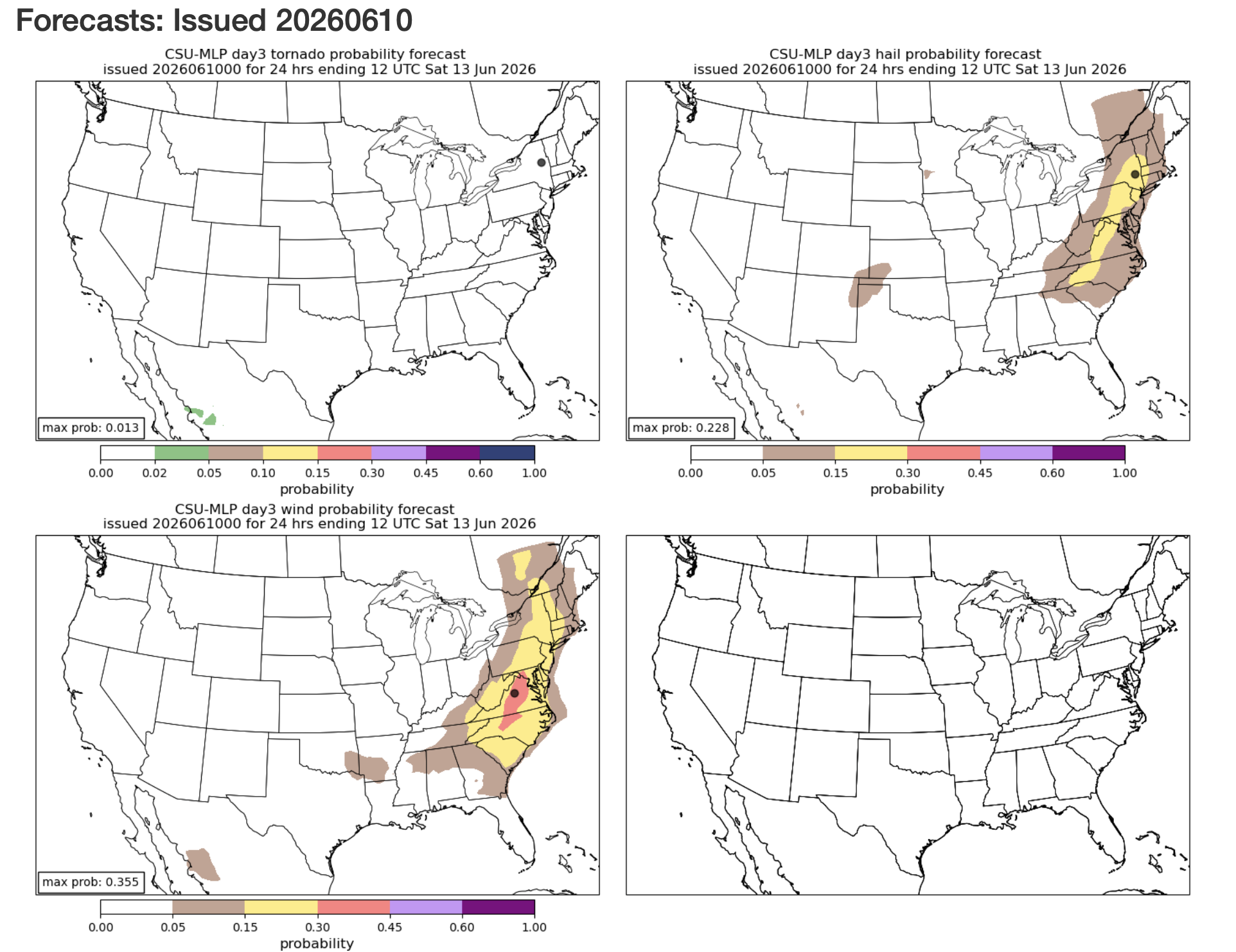
Tomorrows updated outlook from SPC comes out in a few hours, will see if they get a little more bullish. Day 2 Convective Outlook NWS Storm Prediction Center Norman OK 1245 AM CDT Wed Jun 10 2026 ...Mid-Atlantic into central Appalachians... Daytime heating coupled with dewpoints in the 60s to low 70s are expected to yield a weakly capped and moderate to strongly unstable afternoon air mass. Forcing for ascent associated with the disturbances mentioned in the synopsis are expected to foster multiple clusters of thunderstorms capable of damaging winds, especially if organized cold pools can develop. There is some model signal that a corridor of slightly stronger low-level and deep-layer shear will materialize across the lower Hudson Valley Thursday afternoon, which would support some potential for supercells capable of large hail and perhaps a brief tornado. ..Mead.. 06/10/2026
-
There are no flood watches out, yet, but the CAMs are all dumping several inches of rain across parts of the se IA, n IL, ne MO area.
-
Managed a robust .6 out in the sticks before everything fizzled to my east
-
RIP Sycamore IL
-
That's probably a reference to the heat index.
-
79 / 66 DT are coming up. Dealing with clouds and scattered storms/ showers today otherswise warm/muggy low - mid 80s. Hazy Hot Humid Thu - Sun with storms chances focused on Thu pm - Friday but chances for isolated storms each of those days. It'll be interesting to see how much rain can fall fro these storms in the 4 day period thu - sunday. Moderate Mon - Tue before trough into the Midwest / Northeast 6/17 - 6/21. Beyond there warmer - we'll see how much heat can build in the period ahead of next month.
-
About 0.13” for the morning round. Let’s go hrrrr!
-
Short range models seem to be playing catchup with the potential intensity/development this afternoon....it will be interesting to see what happens.
-
It does weaken but still some rain between 5-6.
-
Looks like 3 days of severe potential starting tomorrow
-
Raining going poof here as it moves East.
-
@Ian was always overrated - meh. All kidding - missed you, dude!
-
Does it take it all the way East, even if it were to happen?
-
I joined up. Love the great email summary I get every day. Good luck to all.