All Activity
- Past hour
-

September 2025 OBS-Discussion centered NYC subforum
bluewave replied to wdrag's topic in New York City Metro
This was still the warmest last week of September for many across the region. Time Series Summary for SOMERSET AIRPORT, NJ Click column heading to sort ascending, click again to sort descending. 1 2025-09-30 71.2 1 2 2011-09-30 70.3 0 3 2017-09-30 69.4 0 4 2010-09-30 69.3 0 5 2015-09-30 67.0 0 6 2007-09-30 66.8 0 7 2020-09-30 66.5 0 8 2024-09-30 66.1 0 - 2019-09-30 66.1 0 9 2004-09-30 65.0 0 10 2014-09-30 64.4 0 Time Series Summary for SUSSEX AIRPORT, NJ Click column heading to sort ascending, click again to sort descending. 1 2025-09-30 69.4 1 2 2011-09-30 68.6 0 3 2010-09-30 66.9 0 4 2017-09-30 66.3 0 5 2020-09-30 65.1 0 6 2007-09-30 64.8 0 7 2024-09-30 64.5 0 8 2014-09-30 64.3 0 9 2015-09-30 63.5 0 10 2019-09-30 62.6 0 Time Series Summary for New Brunswick Area, NJ (ThreadEx) Click column heading to sort ascending, click again to sort descending. 1 2025-09-30 73.2 1 2 2017-09-30 72.0 0 3 2011-09-30 71.8 0 4 1959-09-30 71.6 0 - 1920-09-30 71.6 0 5 2010-09-30 71.2 0 6 1945-09-30 71.0 0 7 1933-09-30 70.5 0 8 1923-09-30 69.9 0 9 1910-09-30 69.8 2 10 1970-09-30 69.5 0 Time Series Summary for NEWARK LIBERTY INTL AP, NJ Click column heading to sort ascending, click again to sort descending. 1 1881-09-30 77.5 0 2 2025-09-30 75.0 1 3 1959-09-30 73.3 0 4 2011-09-30 73.1 0 5 2010-09-30 72.6 0 6 1986-09-30 72.1 0 7 2017-09-30 72.0 0 8 1920-09-30 71.1 1 9 2007-09-30 70.5 0 10 2019-09-30 70.4 0 - 1968-09-30 70.4 0 - 1933-09-30 70.4 0 Time Series Summary for WESTCHESTER CO AP, NY Click column heading to sort ascending, click again to sort descending. 1 2025-09-30 71.0 1 2 1959-09-30 70.9 0 3 2011-09-30 69.5 0 4 2017-09-30 69.1 0 5 1970-09-30 69.0 0 6 2010-09-30 68.7 0 7 2007-09-30 67.6 0 8 1986-09-30 66.9 0 9 1968-09-30 66.7 0 10 2020-09-30 66.6 0 Time Series Summary for JFK INTERNATIONAL AIRPORT, NY Click column heading to sort ascending, click again to sort descending. 1 2025-09-30 72.5 1 2 1959-09-30 72.4 0 3 2011-09-30 71.7 0 4 2010-09-30 71.6 0 5 2017-09-30 70.9 0 6 1986-09-30 69.8 0 7 1968-09-30 69.6 0 8 2007-09-30 69.2 0 9 2015-09-30 69.1 0 10 2020-09-30 68.9 0 Time Series Summary for LAGUARDIA AIRPORT, NY Click column heading to sort ascending, click again to sort descending. 1 2025-09-30 74.5 1 2 1959-09-30 74.3 0 3 2007-09-30 73.8 0 4 2010-09-30 73.7 0 5 2011-09-30 72.1 0 6 2017-09-30 72.0 0 7 2020-09-30 71.9 0 8 1986-09-30 71.7 0 9 2019-09-30 71.4 0 10 1968-09-30 69.7 0 - 1945-09-30 69.7 0 Time Series Summary for ISLIP-LI MACARTHUR AP, NY Click column heading to sort ascending, click again to sort descending. 1 2025-09-30 74.0 1 2 2010-09-30 71.1 0 3 2011-09-30 70.7 0 4 2017-09-30 69.6 0 5 2007-09-30 68.1 0 6 2020-09-30 68.0 0 - 1986-09-30 68.0 0 8 2015-09-30 66.9 0 9 1972-09-30 66.4 0 10 2019-09-30 66.3 0 11 2014-09-30 65.9 0 Time Series Summary for NEW HAVEN TWEED AP, CT Click column heading to sort ascending, click again to sort descending. 1 2025-09-30 72.1 1 2 2011-09-30 71.5 0 3 2010-09-30 71.2 0 4 1970-09-30 70.4 2 5 1959-09-30 69.9 0 6 2020-09-30 69.1 0 7 2017-09-30 67.9 0 8 2019-09-30 67.0 0 - 2007-09-30 67.0 0 10 2024-09-30 66.1 0 11 2014-09-30 65.5 0 -
It’s been a real long time since we’ve seen a true predominant +EPO winter. Honestly since 11-12. Ever since then we default to -EPO several times during the winter and haven’t really seen a +EPO “lock in” like that since
-
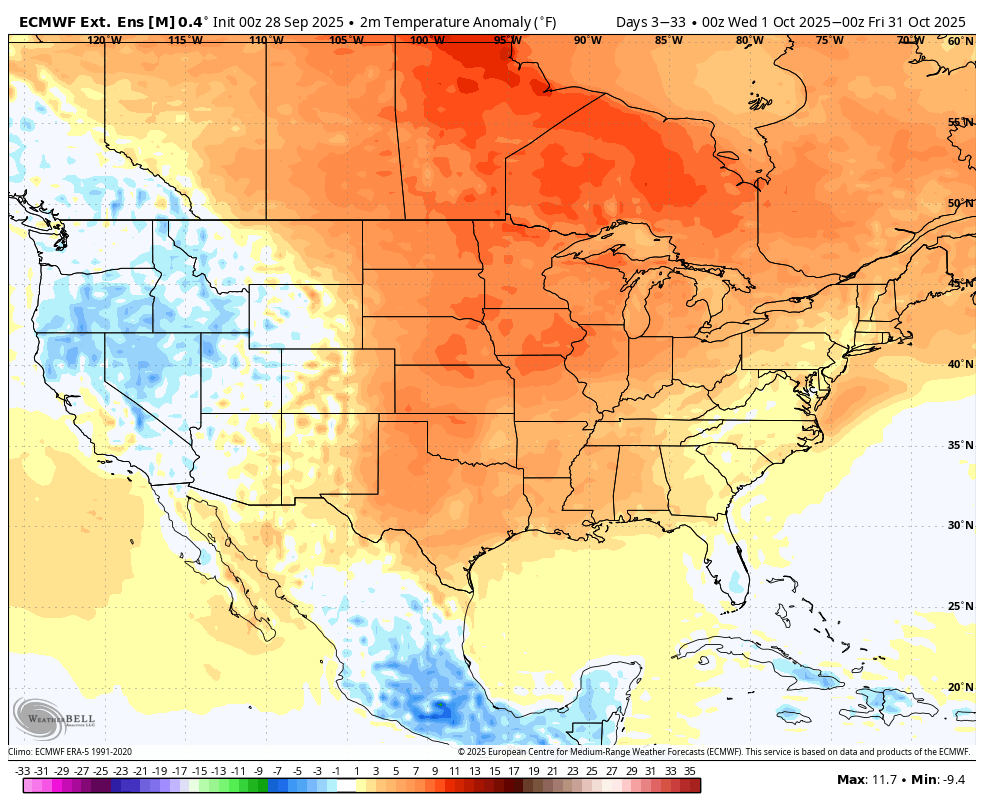
The “warm blob” has been taking a big hit over the last few weeks. Now the question becomes does it come back by December (i.e. 2013)? Or do we see a classic “cold horseshoe” negative PDO alignment develop like Paul Roundy thinks is going to happen?
- Today
-
Downtown Brattleboro was also spectacular, but I didn't dig out my camera. I was on my way to an appointment. I just soaked it in.
-
 DCA _NYC _BOS _ ORD _ATL _IAH __ DEN _PHX _SEA 2.3 2.4 2.5 2.0 1.8 2.3 1.0 0.7 0.4
 -
0.53” for the event so far, 0.78” MTD
-

E PA/NJ/DE Autumn 2025 Obs/Discussion
LVblizzard replied to PhiEaglesfan712's topic in Philadelphia Region
Aurora is out tonight…too bad it’s freaking cloudy. Ugh. -

Fall/Winter Banter - Football, Basketball, Snowball?
John1122 replied to John1122's topic in Tennessee Valley
These overtime games are stressing me to the max, but it's not as bad as it was a few years ago now that you have basically two losses to play with each season. That said, even though Miss State is much improved, we would have won probably be 3 scores if the calls were correct on the pi's and we could catch a football while wide open. -
I mean, I wouldn't bet on the Ravens https://www.cbssports.com/nfl/news/nfl-super-bowl-odds-updates-how-much-did-ravens-move-after-1-3-start-lamar-jackson-injury/ 3 Good WR's, 2 good TE's, Henry and Lamar though.. Justice Hill, Mitchell. it seems to be clicking too. I guess Vegas likes highly powered offenses. High betting odds also means that Lamar's injury probably isn't serious
-
I've heard that towns that were just east of the eye fared the worst in Gloria, so probably places from Bay Shore out to the Hamptons had a lot of trees down. West side of the storm got the most rain, over 5.5 inches in NYC.
-

September 2025 OBS-Discussion centered NYC subforum
winterwarlock replied to wdrag's topic in New York City Metro
80 for a high 7th day in a row of 80 and above -
Funny you say that. We definitely had the 'eye' and I had remembered the warnings from the elders (lol) that once that eye went through it was going to be just as bad again, but the skies pretty much stayed blue as you say. Still the best sustained winds I've ever witnessed, but as years go by I wonder if Sandy was worse, simply because so many more trees went down, even given so many had already been culled by Gloria, the 2010 extended heavy rain/wind event, and Irene leading up to it. What towns do you think fared the worst on LI w/Gloria? I'd always heard it was Massapequa/Amityville. Tobay Beach right on the Nassau Suffolk border seemed like it lost half its sand when we returned the next summer. Went from an endless beach to one where there was little room in spots between the shore and the dunes. It was never the same. To me that was the biggest impact of the storm.
-
JB has been pushing the idea of warm Oct/cold Dec. @snowman19i know you’re shocked lol.
-
What a worthless piece of fake long range forecasting... If it were as simple as using sst anomalies to predict the winter jet stream pattern, every winter forecast would be perfect! It's all modelology with no meteorology. All click bait; headline stating a brutal winter lies ahead, but almost zero support discussed in the video. So typical of today's social media driven weather industry.
-
Thanks Humberto
-

2025-2026 ENSO
so_whats_happening replied to 40/70 Benchmark's topic in Weather Forecasting and Discussion
We peaked earlier this year with the extreme -PDO so the runway is a little bit better.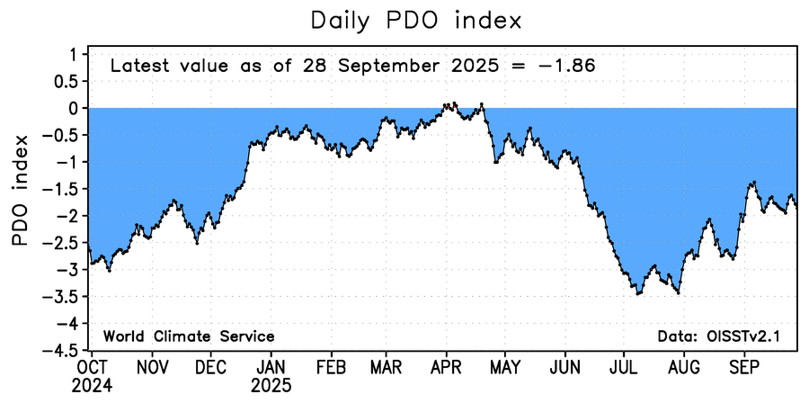
-

-
I'm sure the models will be right but I hope they're wrong.
-

September 2025 OBS-Discussion centered NYC subforum
LibertyBell replied to wdrag's topic in New York City Metro
The gradation is even finer than that. Many times the sea breeze never makes it north of the barrier islands and the south shore is the hottest place. This is what happened in late June. -

2025-2026 Fall/Winter Mountain Thread
Maggie Valley Steve replied to Buckethead's topic in Southeastern States
We've been in the clouds all day with the Wedge firmly established. Drizzle has returned in earnest this evening in the Valley. I had a high of 69 today and a low this morning of 58. Thanks for sharing your amazing pictures Timm! I always look forward to you sharing! -

September 2025 OBS-Discussion centered NYC subforum
jm1220 replied to wdrag's topic in New York City Metro
This time of year after the water warms up the south shore isn't much cooler anymore if at all. Also the last few summers the seabreeze just brought more humidity even if temp went down a few degrees, so no relief. You're also still well away from the barrier islands. -

September 2025 OBS-Discussion centered NYC subforum
psv88 replied to wdrag's topic in New York City Metro
That plus north winds which make the north shore cooler. I have a cool app for the boat called predict wind. Micro level wind forecasts which show how in the summer three general wind zones. North shore, mid island and south shore. Mid island bounces back and forth between north shore and south shore wind directions, when the other 2 can remain steady -
Here's a couple from my game camera in the wood yard. The deer were loving the rain . Not me...
-
Yeah not nearly as crisp a satellite presentation as even a few hours ago. FL winds continue to increase however.
-
Youtubers gone wild....