All Activity
- Past hour
-

Central PA Winter 25/26 Discussion and Obs
mahantango#1 replied to MAG5035's topic in Upstate New York/Pennsylvania
Nice to start seeing the sun at 8:31am instead of 9:12am at my place. Glad to see the days are getting longer. -

The “I bring the mojo” Jan 30-Feb 1 potential winter storm
PeeDeeWx replied to lilj4425's topic in Southeastern States
At this point, is it fair to say that most only need to worry about the dreaded dry slot set ups? -
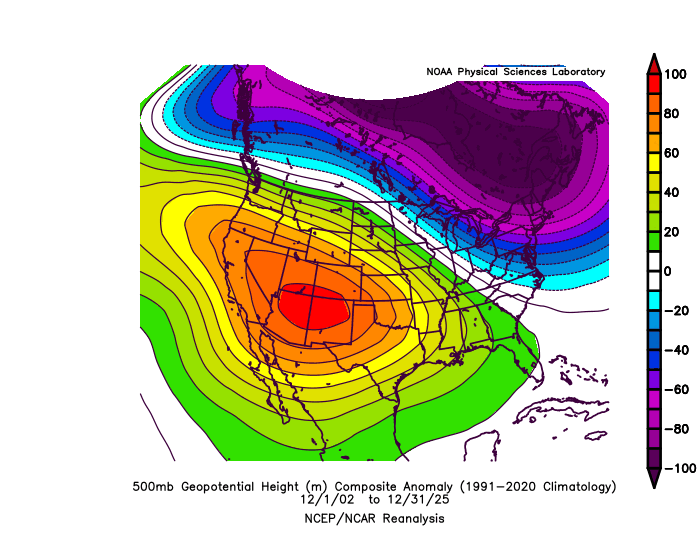
This is one of those rare times that a November 500mb pattern locked in for the winter.


-
The “I bring the mojo” Jan 30-Feb 1 potential winter storm
GunBlade replied to lilj4425's topic in Southeastern States
Getting more negative tilt too would help throw more moisture back that way and setup some great totals. -
Had a few random questions that I figured would fit best in this thread if anyone has knowledge about it: Was curious if snowguns/snowmaking equipment can be dialed in for water content if needed. Or, is it simply air pressure and water forced through a nozzle? Is there a standard water content for man-made snow? Is there a prime percentage resorts go for when making snow? i.e.: 10:1, 15:1, etc Is there any core data from man-made snow? Do resorts ever have a need to check that?
-

The “I bring the mojo” Jan 30-Feb 1 potential winter storm
olafminesaw replied to lilj4425's topic in Southeastern States
Looks good for Raleigh to the coast, drier for the NW Piedmont -

Possible coastal storm centered on Feb 1 2026.
SouthCoastMA replied to Typhoon Tip's topic in New England
At least get me close to warning. Thanks in advance. -

The “I bring the mojo” Jan 30-Feb 1 potential winter storm
mstr4j replied to lilj4425's topic in Southeastern States
It's just one run - but this run is a killer heartbreak for the Upstate of sc - I mean absolute killer. Losing around 0.4 qpf is a ton, considering at least 0.1 of what's there will be virga. Ouch!! I need @lilj4425 to bring us back some MOJO! Lets go baby!!!! -

January 30th- Feb 1st ULL and coastal storm obs
kvegas-wx replied to JoshM's topic in Southeastern States
Anyone have experience with Starlink panels being covered in snow? How quickly does the signal degrade or fail? -

February 2026 Medium/ Long Range Discussion: Buckle Up!
anotherman replied to Weather Will's topic in Mid Atlantic
Sounds familiar. -
HRRR looks like it will be an improvement
-

February 2026 Medium/ Long Range Discussion: Buckle Up!
SomeguyfromTakomaPark replied to Weather Will's topic in Mid Atlantic
Yeah def major, the piles of ice make it look like we had 18 inches. This stuff doesn’t compact or melt in this weather at all. -

February 2026 Medium/ Long Range Discussion: Buckle Up!
stormtracker replied to Weather Will's topic in Mid Atlantic
Come on man. How can you blame us after this week's fiasco? If that didn't happen, I def wouldn't be skeptical. We got snake bit and I'm just weary as hell. And it all started this exact same way. -
The “I bring the mojo” Jan 30-Feb 1 potential winter storm
olafminesaw replied to lilj4425's topic in Southeastern States
The biggest thing that will help Raleigh is if the stall of the coastal occurs south of cape lookout. Will give a chance for banding to build in. Of course, the closer to the coast the better -

The “I bring the mojo” Jan 30-Feb 1 potential winter storm
Rsheely88 replied to lilj4425's topic in Southeastern States
12z HRR not looking as juicy as the 6z did . -

February 2026 Medium/ Long Range Discussion: Buckle Up!
Kmlwx replied to Weather Will's topic in Mid Atlantic
I would argue that the sleet glacier might have nudged the impact of this past storm to major. I know the amounts won't echo that - but the impacts relating to the bitter cold after I think edge this upwards. -
The deep cold and persistent snowpack has been nice, but I also wouldn’t mind getting back in on the action here on the I-90 great lakes corridor. We’ll see how it goes.
-

Possible coastal storm centered on Feb 1 2026.
Cyclone-68 replied to Typhoon Tip's topic in New England
It sucks but I suppose it would have been 100x more awful had we missed the last storm -
(002).thumb.png.6e3d9d46bca5fe41aab7a74871dd8af8.png)
Central PA Winter 25/26 Discussion and Obs
ChescoWx replied to MAG5035's topic in Upstate New York/Pennsylvania
It looks like all stations across the area remained in the single digits above zero with Warwick Twp. our normal cold spot at 2.0 above and of note here in East Nantmeal our low this AM was 3.3 above - this is my coldest reading here since the 3.0 degrees last January 22nd. Today and tonight looks to be a couple of degrees colder than yesterday. We stay in the teens for highs both today and tomorrow before we finally crack the 20-degree mark on Sunday. We see a slight moderating trend through the middle of next week with highs possibly approaching 30 degrees by Tuesday. We could see some snow chances by next Wednesday into Wednesday night. We may turn even colder again by next weekend. The long-range models continue to think while we might get close for a couple of days....they have no days reaching the 32-degree mark through at least mid-February!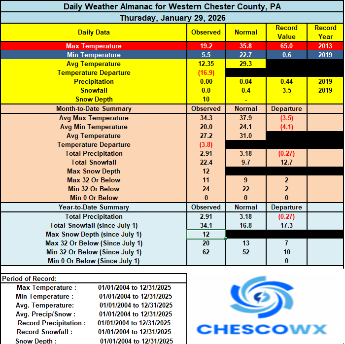
-
E PA/NJ/DE Winter 2025-26 Obs/Discussion
ChescoWx replied to LVblizzard's topic in Philadelphia Region
It looks like all stations across the area remained in the single digits above zero with Warwick Twp. our normal cold spot at 2.0 above and of note here in East Nantmeal our low this AM was 3.3 above - this is my coldest reading here since the 3.0 degrees last January 22nd. Today and tonight looks to be a couple of degrees colder than yesterday. We stay in the teens for highs both today and tomorrow before we finally crack the 20-degree mark on Sunday. We see a slight moderating trend through the middle of next week with highs possibly approaching 30 degrees by Tuesday. We could see some snow chances by next Wednesday into Wednesday night. We may turn even colder again by next weekend. The long-range models continue to think while we might get close for a couple of days....they have no days reaching the 32-degree mark through at least mid-February!
-
That's crazy. Got down to -13 imby.
-

E PA/NJ/DE Winter 2025-26 Obs/Discussion
mattinpa replied to LVblizzard's topic in Philadelphia Region
Thanks! I also wanted to know. -

Winter 2025-26 Medium/Long Range Discussion
DocATL replied to michsnowfreak's topic in Lakes/Ohio Valley
At least we get some good looks even if they fade away in the near term. Can’t wait for a warm April. . -

Central PA Winter 25/26 Discussion and Obs
Superstorm replied to MAG5035's topic in Upstate New York/Pennsylvania
Too much breeze. Tonight may be best chance to get below zero in the southlands. -

The “I bring the mojo” Jan 30-Feb 1 potential winter storm
neverSnowsLCSC replied to lilj4425's topic in Southeastern States
More and more QPF starting to slowly trickle into the lowcountry. NAM 3km shows 6-7" around here. Expecting 1-3, so I'll be pleasantly surprised if we get any more than that. Good luck everyone!


