All Activity
- Past hour
-
GFS still has it at 162. Let’s see how she handles from there
-

“Cory’s in LA! Let’s MECS!” Jan. 24-26 Disco
HoarfrostHubb replied to TheSnowman's topic in New England
I’m not worried. Steady as she goes here -

Jan 24-26 Weekend Snow and Sleetfest Model Thread Part Tres
mitchnick replied to H2O's topic in Mid Atlantic
Purchase at your own risk..thumb.png.9e4a9397866c076008da424224c83930.png)
-

Jan 24-26 Weekend Snow and Sleetfest Model Thread Part Tres
Amped replied to H2O's topic in Mid Atlantic
The rgem solution is what Im hoping for. You get a death band over I95 before the changeover. Thats our best hope getting higher totals to verify. -

January 25/26 Jimbo Back Surgery Storm
Brick Tamland replied to Jimbo!'s topic in Southeastern States
-

MO/KS/AR/OK 2025-2026 Winter Discussion
MUWX replied to stormdragonwx's topic in Central/Western States
I dont think this storm will bring strong enough sustained winds to see blizzard warnings, but could see some blizzardlike conditions. -
-
18z NAM has TYS topping out at 48 degrees Sunday evening. At the same time it's hi-res version and GFS are 34.
-

Possible Record Breaking Cold + Snow Sunday 1/25 - Tuesday 1/27
SACRUS replied to TriPol's topic in New York City Metro
1/23 18z UKMET total QPF Total Snowfall / Sleet: -
January 25/26 Jimbo Back Surgery Storm
Brick Tamland replied to Jimbo!'s topic in Southeastern States
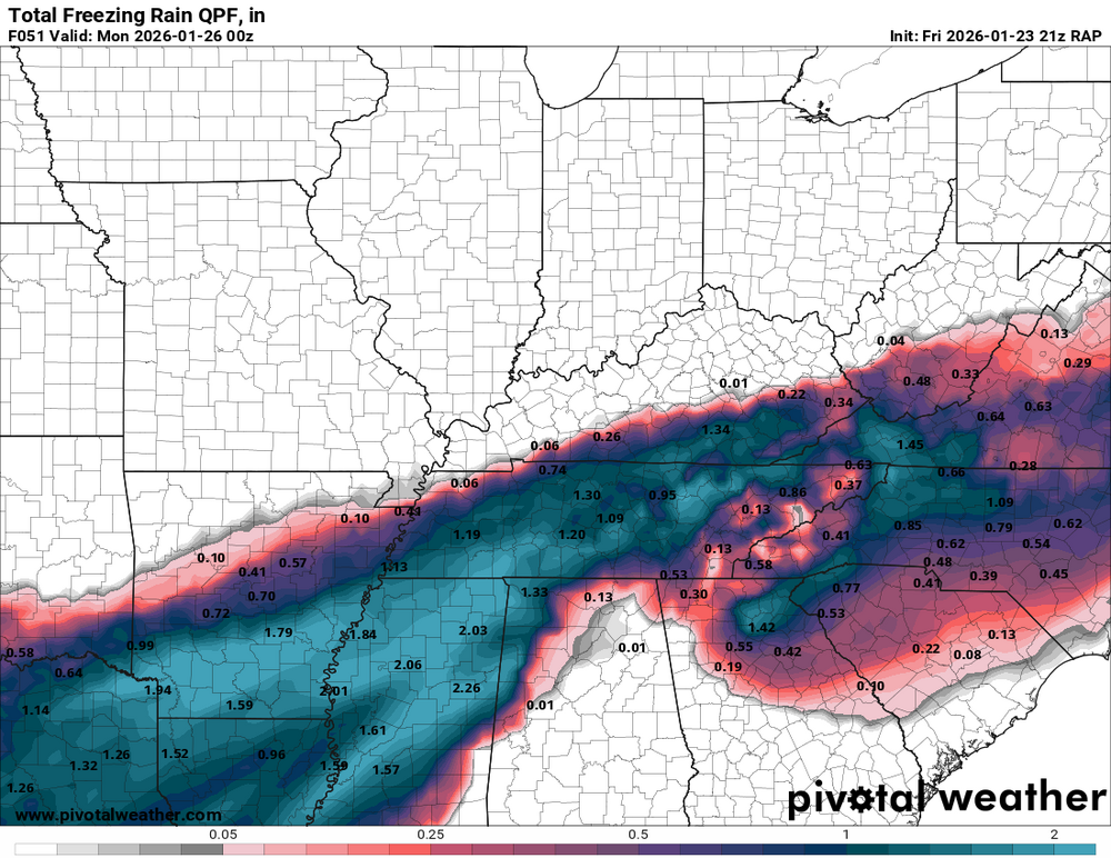
RAP -

Texas 2026 Discussion/Observations
Stx_Thunder replied to Stx_Thunder's topic in Central/Western States
Was there also CG lightning going on up there back then that night? It was just incredible when I saw 2 simultaneous CG strikes (likely positive-charged because they were pretty thick bolts), in just over 35 F wx about a mile from my backyard down here. -
@Matthew70refused to concede that winter was over during the December chinook. Looks like he paid his bill. This is a nice receipt!!! 45/50 states have winter weather products issued.
-

Snow Contest January 25th-26th
Roger Smith replied to WeatherGeek2025's topic in New York City Metro
Good, I was just starting to think about a contest location and format and spotted this ... thanks. NYC: 6.8" (NYC) maybe 8-10 at other locations in the city Boston: 20.4" Philly: 3.7" (lots of sleet) DC: 4.5" (DCA) maybe 7" IAD Hartford: 17.5" Albany: 18.8" Me: As I live outside the storm zone I will add ORH 22.7" and ABE 14.5" -
-
That seems to lock in the cold behind it for the weekend system
-

Pittsburgh/Western PA WINTER ‘25/‘26
colonel717 replied to Burghblizz's topic in Upstate New York/Pennsylvania
This one is in the bag... Time to focus on reeling in next weekend potential. We will most likely be a western edge hit if anything. I wonder how the snow pack after this storm will affect the next one. How will snow pack baroclinic zone set up. -

1/24-1/25 Major Winter Storm - S. IL, IN, and OH
Jackstraw replied to A-L-E-K's topic in Lakes/Ohio Valley
`Still think my call for 7 is still in play. Chance of hitting double digits have diminished some but getting close to a nowcast and subtle changes in QPF can make a BIG difference with these SLR's approaching 25-1, especially on the N/NW side. As OHWeather pointed out the drivers the limiter on "our" side of this thing is going to be how long it takes the DGZ and that dry NE flow at the surface to get juiced and the amount of forcing we can get before it shunts E. As a note, not in our forum but I have a lot of connections in the NC mnt's. A lot of focus has been on deep south ice but I cannot emphasize enough how much more devastating ice in the those mnts just due to limited infrastructure and emergency access. I have been watching the models and every 25-50 years we get a setup like this that could be setting up for the NC/SC mnts. More and more its looking like a strong CAD trapped on the eastern slopes setting up a wedge where the surface low, instead of shunting E through the Chattanooga plateau where they usually do in winter (sad for us), and instead is going to ride up to the Shenandoah valley and shunt E (better for us) there. When this happens you have that warm moist area lifting over the mnts and falling down through that CAD as freezing rain. The setup has to be perfect and this one is as you can see it in the contour fields on the surface maps. Ice storms of this ones potential magnitude there can shut the mnts down for MONTHS. The locals there that have been there a long time are very aware of the devastation a massive ice storm can bring in the mnt's. They actually fear those more than a flooding hurricane remnant. I've seen it myself and it looks like an area the size of Vermont was hit by a bomb. Sorry for the off topic but a lot of concern for them right now. -
 Qpf cut on gfs moving to euro
 -
GFS H5 map has players on the field for next potential...let's see where it goes
-

Possible Record Breaking Cold + Snow Sunday 1/25 - Tuesday 1/27
Stormlover74 replied to TriPol's topic in New York City Metro
Ukie held serve i guess. Its a mess...drier and has snow to Delaware with 552 thickness -

January 25-26 Winter Storm Potential
CoolHandMike replied to Ralph Wiggum's topic in Philadelphia Region
What NAM are you guys looking at? Still seeing double digits region-wide over at TT... What am I missing? -

Jan 24-26 Weekend Snow and Sleetfest Model Thread Part Tres
balltermen replied to H2O's topic in Mid Atlantic
The GFS has trouble with east coast snowstorms. especially with a tricky northern stream Some people have drawn similarities to 2/12/14. The GFS wasn't on board until like 12 hours out. Which is to say. i think its too cold -
 URGENT WEATHER STATEMENTNATIONAL WEATHER SERVICE – WINTER DISAPPOINTMENT DESKISSUED: Immediately, because hope is fragileSUMMARY:A significant winter storm is expected to impact the region. Forecast confidence remains high for heavy snow potential, followed by a dangerous transition to sleet, freezing rain, or the ultimate betrayal: plain rain.⸻HAZARDS:• Initial excitement from model runs showing 18–30 inches• Rapid emotional destabilization as warm nose appears• Keyboard smashing, doom posting, and refresh-induced psychosis• Statements such as “this storm is dead” at T-72 hours⸻SUICIDE WATCH (METEOROLOGICAL): IN EFFECTA Snowlover Emotional Crisis Watch is in effect for the duration of the event.Residents are advised:• Do not do anything rash based on one model run• Step away from social media during the sleet phase• Remember: one band can still save the storm• Refrain from declaring winter “over” before March⸻TIMING:• Snow: Hope Phase• Sleet/Freezing Rain: Anger Phase• Rain: Acceptance (or complete meltdown)• Post-storm: “Next system looks promising” Phase⸻PRECAUTIONARY/PREPAREDNESS ACTIONS:• Touch grass (or snow, if available)• Hydrate• Do not fight family members over 850 mb temps• Seek professional help if you start trusting the GFS blindly⸻FORECAST CONFIDENCE:Low on precipitation typeHigh on emotional damage
 -
Not that. Comes in from PA. Can see it on MSLP and 700 VV.
-
(002).thumb.png.6e3d9d46bca5fe41aab7a74871dd8af8.png)
January 25-26 Winter Storm Potential
ChescoWx replied to Ralph Wiggum's topic in Philadelphia Region
Above is only thru 1pm

.png.1bb011ca582a74e21fe0f88c3ef7f324.png)


