All Activity
- Past hour
-

2025-2026 ENSO
40/70 Benchmark replied to 40/70 Benchmark's topic in Weather Forecasting and Discussion
All 6 of those seasons finished with a mean DM -WPO, so this season should, too....though we could have a month or two average +WPO, as was the case in 1990. Looks like I am going to be off on the WPO again...it's so tough to forecast. At least I didn't go strongly positive.... -

E PA/NJ/DE Winter 2025-26 Obs/Discussion
Mikeymac5306 replied to LVblizzard's topic in Philadelphia Region
Had 14F on the way into work. I'm already done with this weather lol. Unless you like 45 degrees and rain, nothing sexy at all long range. -
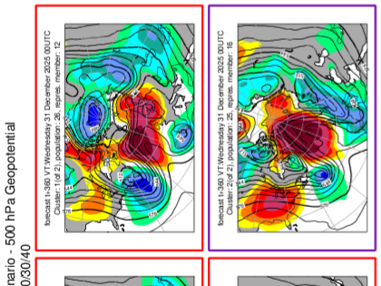
Two clusters on eps cluster analysis in the long range last night. -NAO of unknown impact the general idea. There is a road in some analogs where we start January with a -NAO and as we lose that, the PNA goes positive. Could we take that road this year?
-
18 here
-

December 2025 Short/Medium Range Forecast Thread
Carvers Gap replied to John1122's topic in Tennessee Valley
One thing to watch is how wx modeling responds to potential negatives from the NAO/AO couplet. I highly doubt those details are worked out. Now, an NAO during mid-December is pretty meh in my book, but later in December...it could help. Evidently, I cropped the model information from some of these. The first is the GFS 6z AO plot. The second is the NAO for the 6z GFS. The third is the 0z EPS for the WPO. The fourth is the EPS 0z NAO. The fifth is the AO for the 0z EPS. Those are not bad teleconnections for us. Let's see how modeling builds those into their looks for the medium and LR. -
That was a good watch, thanks for posting it.
-

December 2025 regional war/obs/disco thread
moneypitmike replied to Torch Tiger's topic in New England
If the number of posts reflects the amount of enthusiasm of what the models show, today is about as exciting as Kevin tracking dew points in July. -
December 2025 Short/Medium Range Forecast Thread
Carvers Gap replied to John1122's topic in Tennessee Valley
I also agree the WPO has been a key driver so far this winter. JB has mentioned it a lot. It has been extremely fickle to predict out past two weeks. -
Quite a few single digit readings in central Maryland this morning looking at weather underground observations
-

Central PA Winter 25/26 Discussion and Obs
Voyager replied to MAG5035's topic in Upstate New York/Pennsylvania
Dropped into the singles if you don't do the official round up/down. 9.9 at 7am. -

Central PA Winter 25/26 Discussion and Obs
mahantango#1 replied to MAG5035's topic in Upstate New York/Pennsylvania
4.3 this morning. -
December 2025 Short/Medium Range Forecast Thread
Carvers Gap replied to John1122's topic in Tennessee Valley
The 6z GFS, right on cue, again cuts into the chinook look. The CMC is now on board with this as well. One thing I am noticing in modeling is that across the board it is greatly modifying the warmth as it draws closer. We have seen this happen(in reverse) when advertised cold air masses(which are supposed to last for days....modify and are merely a frontal passage. Right now, the 20th and 22nd look ripe for decent cold fronts. Is it possible the deterministic models were to quick in bringing in the chinook and it still may materialize? Maybe. The chinook pattern has been pushed back by at least 10 days by my count so far. I think it likely we see some chinooks, and some inevitable warm days. I mean, we are due some warm days. TRI has been BN since Nov 26 - every, single day. That is a stretch of nearly three weeks without a single day AN. We live in the sub tropics - it is going to try to get warm in a multitude of ways. TRI has recorded a trace or more of snowfall seven days this month. IMBY, that probably adds up to maybe a couple of inches. The number of days(not the total) with a trace or more is way AN. Right now, TRI is -6.8 to start the month. As for 84-85, JB mentioned it last week. I didn't bring it to the forum with much discussion, because that is a landmark winter. I did mention it to one poster on a sidebar to record the thought, and see what they thought. I pulled the 500 pattern to look at it - made the map myself. The 500 pattern looks exactly the same as the next four weeks on LR ext modeling at 500. It is another reason I have been saying to be careful not to cancel winters. And hey, we may go the way of dreaded '89, or we may score like 95-96 or we may chart an entirely new course (more likely). With so much cold available, all it would take is a decent NAO or EPO(even temporary)...and it discharges. I don't think we go 84-85...but 95-96(light) would be the ceiling in my book. But I think the hand wringing over an inevitable warm-up after three weeks of cold is not something this forum has traditionally taken part in, and hasn't this time. We pride ourselves in not devolving into group think. I also think it very important to look at model biases, and learn to factor those into thinking. The Pac NW feedback is real, and it likely caused erroneous solutions at least for the dates Dec 15-22. The repetitive Baja lows never materialized earlier this month - feedback error. Let's see if that continues. Infinite loops are real problems in computer programming, and wx models are not immune. There is one other winter where this feedback occurred. I will try to dig that winter up today. Our conversations were almost identical as now. I have noted many times. In the IDF(Israeli Defense Forces), if everyone agrees...one person is required to take the other side. It prevents mistakes. I am thankful this forum doesn't try to drown out opposing viewpoints. I think we do a pretty good job of that. That is what makes our forum strong. -

Central PA Winter 25/26 Discussion and Obs
Mount Joy Snowman replied to MAG5035's topic in Upstate New York/Pennsylvania
10 when I left the house but hit 1 on the car therm through the rurals. Also .2” of daily snowfall. -

E PA/NJ/DE Winter 2025-26 Obs/Discussion
Birds~69 replied to LVblizzard's topic in Philadelphia Region
14F at 6:30am. Colder than yesterday at this time which was 16F... -

Winter 2025-26 Medium/Long Range Discussion
A-L-E-K replied to michsnowfreak's topic in Lakes/Ohio Valley
looks mild and boring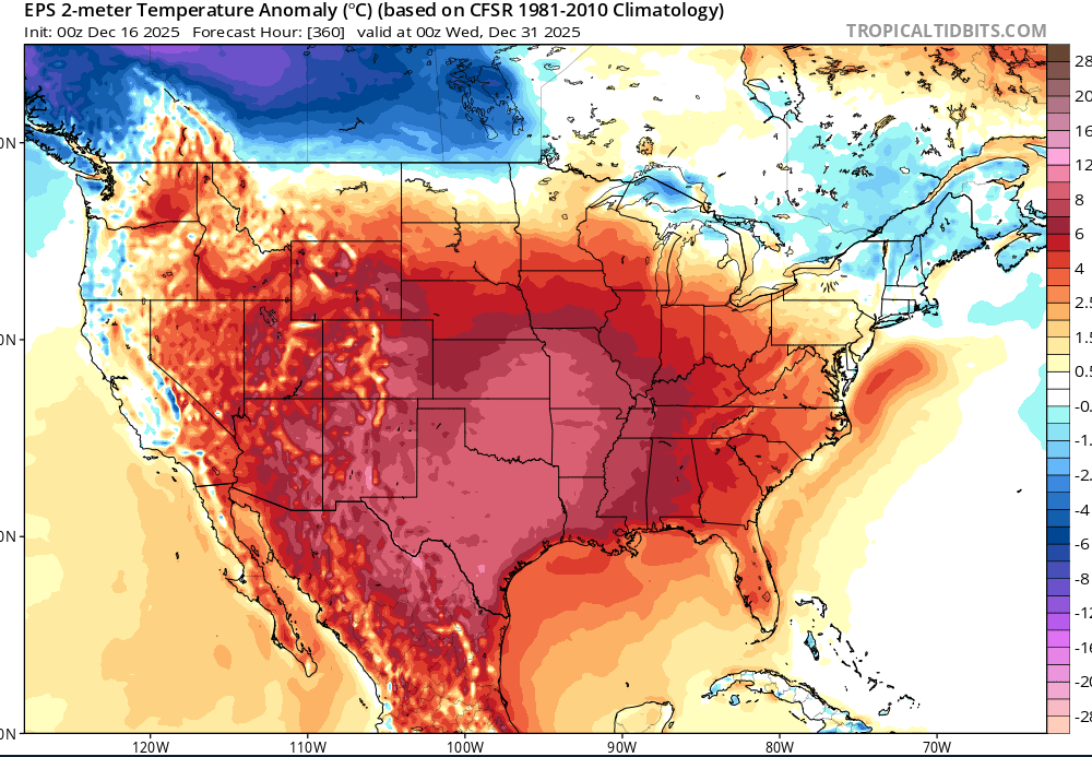
-

2025-2026 Fall/Winter Mountain Thread
franklin NCwx replied to Buckethead's topic in Southeastern States
16 this morning! -
The 1989-90 winter saw what was probably the biggest complete pattern flip in the last 50+ years. We went from a record cold arctic ice box from November through the end of December, then there was a big cutter on New Year’s Eve and a light switch flip to a full on torch for all of January and February
-
insane amounts of snow in British Columbia.. found a 397 amount.. https://www.pivotalweather.com/model.php?m=gfs&p=snku_acc-imp&rh=2025121606&fh=384&r=conus&dpdt=&mc=
-
Central PA Winter 25/26 Discussion and Obs
mahantango#1 replied to MAG5035's topic in Upstate New York/Pennsylvania
COLDEST DECEMBER 1-15 SINCE 2005 Every single day of December 2025 has been cooler than average so far. The last day with above normal temperatures was November 26th (almost 3 weeks ago)! Fear not - the warm up starts today & continues through Thursday. -
You have a great eye for photography and video like Don. I used to be much more active in photography years ago. Enjoyed walking around and taking photos in Manhattan. I would shoot rolls of Kodachrome 64 color snd Tri-x 400 black film. There was an old place that rented darkrooms by the hour at 20W 20th street to develop the black and white. It’s much more convent these days with mobile photography and software.
-
Wasn’t on the euro
-
Currently 9° coldest of the season.
-
I got six inches of snow, followed by many hours of freezing drizzle. Felt like a bust, with how much the TV mets were hyping it up.